Canyoneering Route Description
Pipe Spring Canyon - 3A III
Zion National Park, Utah.
08-03-12, 4 people, 1 Day (Travel time in route 8 hours)

07-18-20, 3 people, 1 Day (Travel time in route 7.75 hours)
Time Required - 7 to 9 hours
Distance - 4.9 miles Total, 0.2 miles Technical
Rappels - 8 Rappels, Longest Rappel 180 feet.
Elevation Range - 7470 - 5890 Feet
Shuttle Required - No Vehicle - Passenger
Permit Required - No
Rappelling and anchor gear, Ropes and or pull cords for rappels up
to 180 feet and 90 feet of 1 inch webbing for sling placement.
Part way up the infamous MIA Exit, the route goes by the bottom
of a side canyon sometimes referred to as the MIA slot. Pipe Spring
Canyon is that MIA Slot. Exiting Pipe Springs Canyon uses the last
portion of the standard MIA Exit.
The hike into the top of Pipe Springs Canyon and the
hike out after going up the steep hill of the MIA Exit uses a web of roads
weaving through the area. There are multiple ways through these roads.
The route described here is the most direct.
Pipe Spring Canyon has some amazingly beautiful narrow
slots sections that are very worth checking out. If you are in need of
a semi-short day and want to see some great deep narrow slot slots, Pipe
Springs is the ticket. Wet suits are not needed but you may have
thigh deep water in a few spots.
To get to the Trailhead
From the South Gate of Zion National Park, drive about 14 miles
west on highway 9 to the turn off for the Kolob Reservoir Road.
Follow the Kolob Reservoir Road 20.1 miles to the turn off for
Lava Point (extLavaPoint). Turn right and follow Lava Point
Road 2.2 miles to the West Rim Trailhead (tWestRimN). There are
few roads around Lava Point which may mislead but there are
signs that will point you toward the West Rim Trailhead at Lava
Point where your route will begin.
To leave the Exit Vehicle / Escape Pod
No exit vehicle is needed. This is done as a loop route.
GPS coordinate information listed at the bottom. For information about waypoint naming and map symbols, refer to the
Glossary page.

Click the links for maps of the route.
Map of the entire route.
Map Zoomed in to show tech section and first half of exit.
The Approach:
From the West Rim Trailhead at Lava Point (tWestRimN), do not follow
the West Rim Trail. Instead walk east along a dirt road about
180 feet to a gate (wMIAgate).
Do not drive past this
gate. You may find the
gate locked on your
return. Continue walking east along the
dirt road.
About 0.8 miles farther is a faint old logging road (wBoundaryRP-01)
that branches off to the left (north) which can be followed into
Boundary Canyon. This road will likely be passed un-noticed as
you go into Pipe Spring Canyon. Pass this old logging road
staying on the main dirt road.
About 0.3 miles
farther is a junction in the road (wMIA-RP-15), stay left at this
fork continuing east.
About 500 feet farther is a tee in the road (wMIA-RP-14),
turn right at this tee and continue southeast.
About 0.22 miles farther is a gate nailed to a tree with Top King
welded into it (wMIA-RP-13Gate), continue southeast down the road.
Note: This gate also marks
the park boundary. To the
west toward the West Rim
Trailhead is in the park.
About 0.2 miles farther is a junction (wMIA-RP-12),
stay straight (left) and continue down the road to the southeast. Do
not turn right onto the side road going south.
About 0.2 miles farther is a fork in the road (wMIA-RP-11),
stay straight (left) and continue down the road to the southeast as
the road becomes less traveled. Do not turn right onto the side road
going south.
About 500 feet farther
is a bend (wMIA-RP-10)
in the road,
follow the bend to the
right and travel down
the road to the south.
About 400 feet
farther is another bend (wMIA-RP-09)
in the road,
follow the bend the left
and continue southeast
down the road.
About 200 feet farther
the faint road you are
on meets a well graded
wide dirt road (wMIA-RP-08),
turn right and follow
the well graded road
down to the southwest.
About 200 feet farther
is a junction in the
road (sPipeSpring) with
a sign for Lady Bug and
Lower Campground.
There used to be a pipe
with flowing spring
water but has since been
removed. To go to
Pipe Spring Canyon,
follow the road going
down to the southeast
for about 450 feet to
where the road becomes
less traveled and fades
to trail.
About 450 feet farther
is a small clearing in
the road where a trail (jPipeSpringCyn)
leads away from the road
down the steep slope on
the left (north) into
Pipe Spring Canyon.
There may be a picnic
table and various signs
since this is used by
the church as youth
recreation spot. Turn
left (north) and
scramble down into Pipe
Springs Canyon. As you
scramble into the canyon
you may find various
ropes, ladders and other
items placed to make
travel up and down the
steep walls easier.
At the bottom of the
scramble down you are in
Pipe Spring Canyon ready
to play (yPipeSpringTp).
The Canyoneering / Technical Section:
Once down in Pipe
Spring Canyon (yPipeSpringTp)
continue a short
distance east down
canyon through sections
of vegetation for about
80 feet to rap 1.
Rap 1 (dPipeSpR1-2)
Rap 1, anchored from
large pine tree on LDC
side and drops about 90
feet into a narrow slot.
Rap 2, at the bottom of
rap 1, anchored LDC from
2 bolted hangers head
high and drops about 100
feet.
Note: On my first visit
the bolts for rap 2 were
not present and we
combined raps 1 and 2 as
a single 190 foot rap
Down canyon of rap 2 are
a few short easy
downclimbs of 5 or 6
feet over about 150 feet
down to the next rappel.
Rap 3 (dPipeSpR3) is
anchored head high RDC
from 1 piton and one
bolted anchor and drops
about 50 feet down a
very cool fluted slot.
Down canyon of rap 3 is
a very pretty section of
slot to walk / scramble
through with lots of
small log debris in
spots. Almost 200
feet down canyon the
walls open up to a
vegetated section and a
short walk over to the
next rap.
Rap 4(dPipeSpR4) is
anchored from a tree up
on the LDC ledge and
drops about 35 feet down
a fluted chute down into
more deep feeling slot.
A short distance down
canyon is a large chock
stone in the wash that
may have webbing on it
to assist with a 20 foot
downclimb. The downclimb
is well featured but
does have slick walls so
care should be taken not
to slip. At the bottom
of the downclimb is the
top of the next rap.
Rap 5 (dPipeSpR5-6)
at the bottom of a
fluted downclimb, is
anchored LDC from 1
piton and 1 bolted
hanger and drops about
160 or 180 feet
depending on the anchor
chosen for the next
rappel. At about
160 feet is a ledge
system you can traverse
RDC to a large tree
anchor (stay on rope
while traversing the
ledge). Or you can
continue slightly LDC
down the main water
course using about 180
feet of rope to a small
pocket in the wall with
a set of two bolted
hangers.
Rap 6, at the bottom of
rap 5, drops about 110
feet if using the large
tree from the ledge or
about 95 feet if using
the bolted hangers a
farther down.
Note:
Both anchor
options for rap 5 (the
tree on the ledge or the
bolts in the rock
pocket) have room for 2
people and would be
awkward for more. Having
enough rope to have both
rappels active at the
same will help larger
groups play through this
set more fluidly.
Note:
I have not
had issues with but have
been told that some have
had their ropes from rap
5 get stuck when pulling
the ropes down from the
tree anchor for rap 6.
Shortly down canyon of
rap 6 the start of a
very pretty narrows
about 4 feet wide with a
few downclimbs before reaching rap
7.
Rap 7 (dPipeSpR7) is
anchored LDC from a
single bolted hanger and
drops about 10 feet. Can
be handlined easily.
Continuing down canyon are a couple
more quick easy
downclimbs before
reaching the next rap
about 100 feet down
canyon.
Rap 8 (dPipeSpR8) is
anchored LDC from a
single bolted anchor and
drops about 15 feet.
From here it is about
150 feet to the end of
the canyon with a couple
short downclimbs
between. The end
of the canyon is about
150 feet down canyon (yPipeSpringBt)
with a couple of
downclimbs of 6 to 8
feet along the way.
The Exit:
From the bottom
of Pipe Spring Canyon (yPipeSpringBt),
turn left and start
northwest up the
drainage.
About 200 feet farther is a fork (wMIA-RP-06) in drainage as you go
up the MIA Exit. At this fork look to the left (south) of the left fork to
find then follow up a steep use trail up to the west. The trail
roughly follows the side of the left fork of the drainage going up
steep dirt slopes through vegetation. After about 300 feet the use
trails level off slightly and become more easily traveled along the
base of the cliff wall. Once on better trail near the base of the
cliff wall, continue up about 250 more feet to where the trail
crosses over the large drainage you have been roughly following.
Note:
From this fork up to the
dirt roads above is about
650 feet of elevation gain
over about 1000 horizontal
feet.
The first 300 feet is
steep and as of 2020 is
beginning to erode
significantly into sections
of steep soft sand.
As the use trail crosses (wMIA-RP-07) a shelf in the drainage /
ravine to the other side. Looking up from here you will see the
sheer rock wall of the canyon then a prominent rock outcropping
slightly to the right up near the rim. The view may be obscured by
trees so keep an eye out. To the right of the rock out cropping is a
tall dead tree. After crossing the ravine continue west up the steep
hill in thicker vegetation and much less obvious use trail. There is
no one best way up this last 450 feet of steep loose hill side. Be
very careful of loose rock and sandy ledges.
Note: In years past there
used to be 3 tall dead trees
you could see up on the rim,
which made for a great
landmark. As of 2020 two of
the trees have fallen and
there is now just one tall
dead tree making the
landmark less noteworthy.
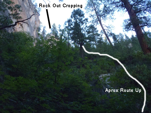
This is a view of the out cropping and the approximate route up the last part of the climb.
Once up on the large well graded dirt road (jMIA-climb/rd) turn left
walking south up the well graded dirt road for about 360 feet to
find an old no longer used road on the right (west).
Note:
There are
multiple ways through the web of roads back to the West Rim
Trailhead. The route described is the most direct route.
Once you find the old not well used road (wMIA-RP-08) going up the
hill to the right (west), turn right and leave the main dirt road
and walk west up the semi steep not well used road.
About 200 feet up the old side road is a bend in the road
(wMIA-RP-09), follow the
bend to the right and
continue north up the road.
About 425 feet farther is another bend in the road
(wMIA-RP-10), follow the bend to the left and travel up the
road to the northwest.
A little over 500 feet farther is a fork in the road (wMIA-RP-11),
stay straight (right) and continue up the road to the northwest. Do
not turn left onto the side road going south.
About 0.2 miles up the road is a junction (wMIA-RP-12),
stay straight (right) and continue up the road to the northwest. Do
not turn left onto the side road going south.
About 0.2 miles up the road is gate nailed to a tree with Top
King welded into it (wMIA-RP-13), continue northwest up the road.
Note:
This gate also
marks the park boundary. To
the west toward the West Rim
Trailhead is in the park.
Another 0.2 miles is a Tee in the road (wMIA-RP-14), turn left
at this tee and start down a hill to the west.
About 500 farther is fork in the road (wMIA-RP-15), continue
straight at this fork passing a road that joins in from the left
(south east).
Continue on the road a little over 1 mile back to the West Rim
Trailhead.
Downloadable GPX files
available at
BG-Gear Store
(easier than manual entry and a great way to support
Bluugnome).
Waypoint naming convention and map symbol information can be found on the Glossary page.
Elevations are approximate.
BEFORE
manually entering coordinates set your system to WGS84 datum and Lat/Lon hddd.ddddd° coordinate format.
Inconsistent datum's and coordinate formats will result in location errors.
Click to show / expand the list of waypoints below........
| Pipe Spring Canyon (1) - Drive into Trailhead. |
- extKolobRes
Lat/Lon (WGS84): N 37.20374
W -113.18604
Elev: NaN Feet
Turn off for Kolob Reservior Raod.
- tLftFrkNrthCk
Lat/Lon (WGS84): N 37.28480
W -113.09576
Elev: 5,070 Feet
Trailhead for the Left Fork of North Creek trail.
- tWildCatCyn
Lat/Lon (WGS84): N 37.33985
W -113.07587
Elev: 6,970 Feet
Wild Cat Canyon Trailhead.
- extLavaPoint
Lat/Lon (WGS84): N 37.39454
W -113.05287
Elev: 7,898 Feet
Turn off for Lava Point off of the Kolob Reservoir Road.
- tWestRimN
Lat/Lon (WGS84): N 37.38155
W -113.02298
Elev: 7,470 Feet
Northern trailhead for the West Rim Trail (by Lava Point).
|
| Pipe Spring Canyon (2) - Approach. |
- tWestRimN
Lat/Lon (WGS84): N 37.38155
W -113.02298
Elev: 7,470 Feet
Northern trailhead for the West Rim Trail (by Lava Point).
- wMIAgate
Lat/Lon (WGS84): N 37.38190
W -113.02256
Elev: NaN Feet
MIA Gate. Do not drive past this gate. You may find the gate locked on your return. To go to Pipe Spring or Boundary Canyons, walk east on the dirt road.
- wBoundaryRP-01
Lat/Lon (WGS84): N 37.38560
W -113.01066
Elev: 7,245 Feet
A faint old logging road leaves the MIA road here and traveling north toward Boundary Canyon.
To go to Boundary Canyon follow the old logging road north. The road is easily missed so look close. Note that if you are going to Boundary Canyon and accidentally pass this faint logging road, you will get to a major fork in the dirt road about 1600 feet past this faint road and will need to turn around.
To go to Pipe Spring Canyon, continue eastish on the main dirt road.
- wMIA-RP-15
Lat/Lon (WGS84): N 37.38435
W -113.00538
Elev: NaN Feet
Junction in the road.
To go to Pipe Springs Canyon stay left at this fork continuing east.
To go to the West Rim Trailhead, continue straight at this fork passing a road that joins in from the left (south east).
- wMIA-RP-14
Lat/Lon (WGS84): N 37.38471
W -113.00358
Elev: NaN Feet
A Tee in the Road.
To go to Pipe Springs Canyon, turn right at this tee and continue southeast.
To go to the West Rim Trailhead, turn left at this tee and start down a hill to the west.
- wMIA-RP-13Gate
Lat/Lon (WGS84): N 37.38306
W -113.00042
Elev: 7,090 Feet
Gate nailed to a tree with Top King welded into it.
To go to Pipe Springs Canyon, continue southeast down the road.
To go to the West Rim Trailhead, continue northwest up the road.
Note: This gate also marks the park boundary. To the west toward the West Rim Trailhead is in the park.
- wMIA-RP-12
Lat/Lon (WGS84): N 37.38206
W -112.99688
Elev: 6,960 Feet
Junction in the road.
To go to Pipe Spring Canyon, stay straight (left) and continue down the road to the southeast. Do not turn right onto the side road going south.
To go to the West Rim Trailhead, stay straight (right) and continue up the road to the northwest. Do not turn left onto the side road going south.
Note: The road to the south from here can be used to go down to Pipe Spring but is longer.
- wMIA-RP-11
Lat/Lon (WGS84): N 37.38123
W -112.99338
Elev: NaN Feet
Fork in the road.
To go to Pipe Spring Canyon, stay straight (left) and continue down the road to the southeast as the road becomes less traveled. Do not turn right onto the side road going south.
To go to the West Rim Trailhead, stay straight (right) and continue up the road to the northwest. Do not turn left onto the side road going south.
- wMIA-RP-10
Lat/Lon (WGS84): N 37.38083
W -112.99173
Elev: NaN Feet
Bend in the road.
To go to Pipe Spring Canyon, follow the bend to the right and travel down the road to the south.
To go to the West Rim Trailhead, follow the bend to the left and travel up the road to the northwest.
- wMIA-RP-09
Lat/Lon (WGS84): N 37.37972
W -112.99173
Elev: NaN Feet
A bend in the road.
To go to Pipe Spring Canyon, follow the bend the left and continue southeast down the road.
To go to the West Rim Trailhead, follow the bend to the right and continue north up the road.
- wMIA-RP-08
Lat/Lon (WGS84): N 37.37944
W -112.99105
Elev: NaN Feet
Very faint not well used road droppping down to the main dirt road.
To go to Pipe Spring Canyon, turn right and follow the well graded road down to the southwest.
To go to the West Rim Trailhead, leave the main dirt road and walk west up the semi steep not well used road.
- sPipeSpring
Lat/Lon (WGS84): N 37.37912
W -112.99171
Elev: NaN Feet
Junction in the road with a sign for Lady Bug and Lower Campground. There used to be a pipe with flowing spring water but has since been removed.
To go to Pipe Spring Canyon, follow the road going down to the southeast for about 450 feet to where the road becomes less traveled and fades to trail.
- jPipeSpringCyn
Lat/Lon (WGS84): N 37.37866
W -112.99038
Elev: 6,510 Feet
Small clearing in the road where a trail leads away from the road down the steep slope on the left (north) into Pipe Spring Canyon. There may be a picnic table and various signs since this is used by the church as youth recreation spot. Turn left (north) and scramble down into Pipe Springs Canyon. As you scramble into the canyon you may find various ropes, ladders and other items placed to make travel up and down the steep walls easier.
- yPipeSpringTp
Lat/Lon (WGS84): N 37.37889
W -112.99029
Elev: 6,500 Feet
Top of Pipe Spring Canyon where the trail down from the rim meets the canyon floor. Continue a short distance east down canyon through sections of vegetation for about 80 feet to rap 1.
|
| Pipe Spring Canyon (3) - The Canyon. |
- yPipeSpringTp
Lat/Lon (WGS84): N 37.37889
W -112.99029
Elev: 6,500 Feet
Top of Pipe Spring Canyon where the trail down from the rim meets the canyon floor. Continue a short distance east down canyon through sections of vegetation for about 80 feet to rap 1.
- dPipeSpR1-2
Lat/Lon (WGS84): N 37.37892
W -112.98971
Elev: NaN Feet
Raps 1 and 2 - Pipe Spring Canyon.
Rap 1, anchored from large pine tree on LDC side and drops about 90 feet into a narrow slot.
Rap 2, at the bottom of rap 1, anchored LDC from 2 bolted hangers head high and drops about 100 feet.
Note: On my first visit the bolts for rap 2 were not present and we combined raps 1 and 2 as a single 190 foot rap.
- dPipeSpR3
Lat/Lon (WGS84): N 37.37888
W -112.98917
Elev: NaN Feet
Rap 3 - Pipe Spring Canyon. Anchored head high RDC from 1 piton and one bolted anchor and drops about 50 feet down a very cool fluted slot.
Down canyon of rap 3 is a very pretty section of slot to walk / scramble through with lots of small log debris in spots. Almost 200 feet down canyon the walls open up to a vegetated section and a short walk over to the next rap.
- dPipeSpR4
Lat/Lon (WGS84): N 37.37872
W -112.98830
Elev: 6,290 Feet
Rap 4 - Pipe Spring Canyon. Anchored from a tree up on the LDC ledge and drops about 35 feet down a fluted chute down into more deep feeling slot.
A short distance down canyon is a large chock stone in the wash that may have webbing on it to assist with a 20 foot downclimb. The downclimb is well featured but does have slick walls so care should be taken not to slip. At the bottom of the downclimb is the top of the next rap.
- dPipeSpR5-6
Lat/Lon (WGS84): N 37.37871
W -112.98811
Elev: NaN Feet
Raps 5 and 6 - Pipe Spring Canyon.
Rap 5, at the bottom of a fluted downclimb, anchored LDC from 1 piton and 1 bolted hanger and drops about 160 or 180 feet depending on the anchor chosen for the next rappel. At about 160 feet is a ledge system you can traverse RDC to a large tree anchor (stay on rope while traversing the ledge). Or you can continue slightly LDC down the main water course using about 180 feet of rope to a small pocket in the wall with a set of two bolted hangers.
Rap 6, at the bottom of rap 5, drops about 110 feet if using the large tree from the ledge or about 95 feet if using the bolted hangers a farther down.
Note: Both anchor options for rap 5 (the tree on the ledge or the bolts in the rock pocket) have room for 2 people and would be awkward for more. Having enough rope to have both rappels active at the same will help larger groups play through this set more fluidly.
Note: I have not had issues with but have been told that some have had their ropes from rap 5 get stuck when pulling the ropes down from the tree anchor for rap 6.
Shortly down canyon of rap 6 the start of a very pretty narrows about 4 feet wide with a few downclimbs before reaching rap 7.
- dPipeSpR7
Lat/Lon (WGS84): N 37.37883
W -112.98763
Elev: NaN Feet
Rap 7 - Pipe Springs Canyon. Anchored LDC from a single bolted hanger and drops about 10 feet. Can be handlined easily. Continuing down canyon are a couple more quick easy downclimbs before reaching the next rap about 100 feet down canyon.
- dPipeSpR8
Lat/Lon (WGS84): N 37.37887
W -112.98728
Elev: NaN Feet
Rap 8 - Pipe Spring Canyon. Anchored LDC from a single bolted anchor and drops about 15 feet. From here it is about 150 feet to the end of the canyon with a couple short downclimbs between. The end of the canyon is about 150 feet down canyon with a couple of downclimbs of 6 to 8 feet along the way.
- yPipeSpringBt
Lat/Lon (WGS84): N 37.37914
W -112.98696
Elev: 5,890 Feet
Bottom of the Pipe Spring Canyon..
|
| Pipe Spring Canyon (4) - Exit. |
- yPipeSpringBt
Lat/Lon (WGS84): N 37.37914
W -112.98696
Elev: 5,890 Feet
Bottom of the Pipe Spring Canyon..
- wMIA-RP-06
Lat/Lon (WGS84): N 37.37942
W -112.98762
Elev: 5,984 Feet
Fork in drainage as you go up the MIA Exit. At this fork look to the left (south) of the left fork to find then follow up a steep use trail up to the west. The trail roughly follows the side of the left fork of the drainage going up steep dirt slopes through vegetation. After about 300 feet the use trails level off slightly and become more easily traveled along the base of the cliff wall. Once on better trail near the base of the cliff wall, continue up about 250 more feet to where the trail crosses over the large drainage you have been roughly following.
Note:
From this fork up to the dirt roads above is about 650 feet of elevation gain over about 1000 horizontal feet.
The first 300 feet is steep and as of 2020 is beginning to erode significantly into sections of steep soft sand.
- wMIA-RP-07
Lat/Lon (WGS84): N 37.37962
W -112.98922
Elev: 6,238 Feet
Use trail crosses a shelf in the drainage / ravine to the other side. Looking up from here you will see the sheer rock wall of the canyon then a prominent rock outcropping slightly to the right up near the rim. The view may be obscured by trees so keep an eye out. To the right of the rock out cropping is a tall dead tree. After crossing the ravine continue west up the steep hill in thicker vegetation and much less obvious use trail. There is no one best way up this last 450 feet of steep loose hill side. Be very careful of loose rock and sandy ledges.
Note: In years past there used to be 3 tall dead trees you could see up on the rim, which made for a great landmark. As of 2020 two of the trees have fallen and there is now just one tall dead tree making the landmark less noteworthy.
- jMIA-climb/rd
Lat/Lon (WGS84): N 37.38031
W -112.99060
Elev: 6,540 Feet
Junction where the climb up the MIA Exit intersects with a road.
To go to the West Rim Trailhead, turn left walking south up the well graded dirt road for about 360 feet to find an old no longer used road on the right (west).
Note: There are multiple ways through the web of roads back to the West Rim Trailhead. The route described is the most direct route.
- wMIA-RP-08
Lat/Lon (WGS84): N 37.37944
W -112.99105
Elev: NaN Feet
Very faint not well used road droppping down to the main dirt road.
To go to Pipe Spring Canyon, turn right and follow the well graded road down to the southwest.
To go to the West Rim Trailhead, leave the main dirt road and walk west up the semi steep not well used road.
- wMIA-RP-09
Lat/Lon (WGS84): N 37.37972
W -112.99173
Elev: NaN Feet
A bend in the road.
To go to Pipe Spring Canyon, follow the bend the left and continue southeast down the road.
To go to the West Rim Trailhead, follow the bend to the right and continue north up the road.
- wMIA-RP-10
Lat/Lon (WGS84): N 37.38083
W -112.99173
Elev: NaN Feet
Bend in the road.
To go to Pipe Spring Canyon, follow the bend to the right and travel down the road to the south.
To go to the West Rim Trailhead, follow the bend to the left and travel up the road to the northwest.
- wMIA-RP-11
Lat/Lon (WGS84): N 37.38123
W -112.99338
Elev: NaN Feet
Fork in the road.
To go to Pipe Spring Canyon, stay straight (left) and continue down the road to the southeast as the road becomes less traveled. Do not turn right onto the side road going south.
To go to the West Rim Trailhead, stay straight (right) and continue up the road to the northwest. Do not turn left onto the side road going south.
- wMIA-RP-12
Lat/Lon (WGS84): N 37.38206
W -112.99688
Elev: 6,960 Feet
Junction in the road.
To go to Pipe Spring Canyon, stay straight (left) and continue down the road to the southeast. Do not turn right onto the side road going south.
To go to the West Rim Trailhead, stay straight (right) and continue up the road to the northwest. Do not turn left onto the side road going south.
Note: The road to the south from here can be used to go down to Pipe Spring but is longer.
- wMIA-RP-13Gate
Lat/Lon (WGS84): N 37.38306
W -113.00042
Elev: 7,090 Feet
Gate nailed to a tree with Top King welded into it.
To go to Pipe Springs Canyon, continue southeast down the road.
To go to the West Rim Trailhead, continue northwest up the road.
Note: This gate also marks the park boundary. To the west toward the West Rim Trailhead is in the park.
- wMIA-RP-14
Lat/Lon (WGS84): N 37.38471
W -113.00358
Elev: NaN Feet
A Tee in the Road.
To go to Pipe Springs Canyon, turn right at this tee and continue southeast.
To go to the West Rim Trailhead, turn left at this tee and start down a hill to the west.
- wMIA-RP-15
Lat/Lon (WGS84): N 37.38435
W -113.00538
Elev: NaN Feet
Junction in the road.
To go to Pipe Springs Canyon stay left at this fork continuing east.
To go to the West Rim Trailhead, continue straight at this fork passing a road that joins in from the left (south east).
- wBoundaryRP-01
Lat/Lon (WGS84): N 37.38560
W -113.01066
Elev: 7,245 Feet
A faint old logging road leaves the MIA road here and traveling north toward Boundary Canyon.
To go to Boundary Canyon follow the old logging road north. The road is easily missed so look close. Note that if you are going to Boundary Canyon and accidentally pass this faint logging road, you will get to a major fork in the dirt road about 1600 feet past this faint road and will need to turn around.
To go to Pipe Spring Canyon, continue eastish on the main dirt road.
- tWestRimN
Lat/Lon (WGS84): N 37.38155
W -113.02298
Elev: 7,470 Feet
Northern trailhead for the West Rim Trail (by Lava Point).
|