Canyoneering Route Description
Boundary Canyon - 3AorC IV
Zion National Park, Utah.
07-18-10, 4 people, 1 Day (Travel time in route 11.5 hours) - MIA Exit

08-08-20, 6 people, 1 Day (Travel time in route 10.75hours) - MIA
Exit - Time includes rappel anchor maintenance.
Exiting via MIA Exit (recommended route)
Time Required - 10 to 12 hours
Distance - 6.6 miles Total, 1.1 miles Technical
Rappels - 9 Rappels, Longest Rappel 100 feet.
Elevation Range - 7540 - 5580 Feet
Shuttle Required -No Vehicle - Passenger Permit Required -
Yes - if using the MIA exit, a permit to cross that land is
required.
Rappelling and anchor gear, Ropes and or pull cords for rappels up
to 100 feet, 40 feet of 1 inch webbing for sling placement, and wet
suits. Wet suits will be needed if the canyon is flowing. There
are no swims in Boundary since the pools are no more than waist
deep. But with the canyon flowing, you will be wet while rappelling
down waterfalls and it does get chilly even in hot months.
Boundary Canyons technical section, although short, is an incredible treat.
More of a treat if water is flowing.
The approach to Boundary uses one of MANY old overgrown logging
roads running like a maze through the area. The approach route described here is one
possible
route into Boundary. I find this one to be the most direct and
easy walking route, provided you know where to turn in the maze of
trails and and old roads. When comparing
notes from multiple sources of beta for this canyon keep in mind
that a different approach route may be described.
Boundary can be rated an A or a C canyon depending on what time of
year you go. Spring runoff can create significant flow or the
canyon may be bone dry later in the year.
Before going down Boundary it is a good idea to check water flow
from the Kolob Reservoir. Flows up around 10 to 15 CFS will make
the trek from Boundary to the MIA Exit a little slower as you
navigate the swift water. Lower CFS levels will make that section a
casual walk down some of the narrows of Kolob Creek. You can check
flow rates by calling the Washington County Water Conservancy
District at 435-673-3617 and ask for the release rate of the Kolob
Reservoir.
Boundary can hold a fair amount of snow so in spring or early
summer it may be a good idea to
check with the Zion Back Country Desk about
recent descent reports.
After the last rappel is the final 0.5 mile of
Boundary Canyon to it's end where it dumps into Kolob Creek.
The exit route then continues south down kolb Creek about 1.2 miles
to the start of the MIA Exit. The MIA Exit allows Boundary
Canyon to be done in a day.
Note:
Optionally you could not use the MIA Exit and instead continue
down Kolob Creek to the Zion Narrows then down the Narrows to the
Temple of Sinawava. Exiting Via the Narrows is best done as an
overnight
trip. If this exit is of interest, check out the Kolob Canyon
route description. The route would be about another 3.2 miles to the Zion Narrows (by
camp site 7), then another 6 miles down the Zion Narrows
to the Temple of Sinawava where you can catch a shuttle back to the
visitor center. After reaching the visitor center you will
36.5 mile car trip to go get your entry vehicle.
For details on this exit route see the route description for Kolob
Creek.
Showing one exit route on one canyon and the other exit option for
the other canyon helps eliminate duplicated information on the web
site. However the GPS coordinates for both exits are listed with
both canyons.
The MIA Exit has a reputation of being difficult to locate and a
pain in the butt to climb out of. If you pay attention on the way
down Kolob Creek, the MIA Exit is not too difficult to locate since
it is the next major drainage on the right (west) downstream of
Boundary Canyon. Locating this exit at night could prove very
difficult though.
The MIA Exit definitely lives up to its name for being difficult.
The MIA Exit starts out steep and eventually gets up to a saddle
where you can view your route down then up to another steep climb. The
second climb up has about 600 feet of elevation gain over about 850
feet of horizontal distance. This does not sound too bad until you
see portions of the route are up steep loose dirt. Allow about 2 or 2.5 hours to climb up the
MIA Exit from Kolob Creek up to a dirt road. Once on the dirt road
it will be about another hour of walking, sometimes steep, dirt roads
back to the car. While walking the roads, pay
attention to the maze so you do not get lost.
To get to the Trailhead
From the South Gate of Zion National Park, drive about 14 miles
west on highway 9 to the turn off for the Kolob Reservoir Road.
Follow the Kolob Reservoir Road 20.1 miles to the turn off for
Lava Point (extLavaPoint). Turn right and follow Lava Point
Road 2.2 miles to the West Rim Trailhead (tWestRimN). There are
few roads around Lava Point which may mislead but there are
signs that will point you toward the West Rim Trailhead at Lava
Point where your route will begin.
To leave the Exit Vehicle / Escape Pod
No exit vehicle is needed if you use the MIA Exit. That route
is done as a loop.
GPS coordinate information listed at the bottom. For information about waypoint naming and map symbols, refer to the
Glossary page.

Click the links for maps of the route.
Map of the entire route.
Zoomed in map of the lower portion of the MIA Exit.
The Approach:
From the West Rim Trailhead at Lava Point (tWestRimN), do not follow
the West Rim Trail. Instead walk north east along a dirt road.
About 180 feet down the road will be a gate (wMIAgate). Even if the
gate is open do not drive down the road or you may find it locked
upon your return. Continue walking east along the MIA Road (dirt).
About 0.8 miles from the gate is a large white gravel clearing
(wBoundaryRP-01) on
the left (north) side of the road at the top of a hill in the road.
To go to Boundary Canyon, leave the road to the left (north) at the
clearing and follow a faint trail north about 250 feet to a ridge
then follow the trail down the ridge.
Note: The trail leaving the road is faint and easily missed if not
looking As the trail goes down the ridge it soon drops and joins
into an old logging road.
Note: If you get to a major fork in
the main road while hiking in then you missed spot to leave the road
and will need to turn around and walk back about 1600 feet.
About 450 feet farther the use trail meets wider portions of the old
logging road (wBoundaryRP-02). Continue following the old logging
road north.
About 400 feet farther is a small clearing (wBoundaryRP-03) where
the logging road appears to dead end in a clearing. At this clearing
turn sharp right (south) and follow a path through the bushes a
short distance until the road becomes easy to follow again as it
goes from south to east.
About 500 feet farther is a very small clearing (wBoundaryRP-04). At
this small clearing turn left following a path leading north down
hill. Do not continue straight on the path to the path continuing
slightly uphill to the east.
About 300 feet farther is a trail junction (wBoundaryRP-05). Turn
right (north east) and follow down a ravine down to the southeast.
About 1000 feet farther the route meets a trail (yBoundaryTp)
that parallels along the upper creek of Boundary Canyon. Turn right
and follow the trail east along the RDC (south) side of the creek.
The Canyon / Technical Section:
Once you are on the trail that runs along the Boundary Canyon Creek
(yBoundaryTp) turn east and follow the trail down canyon about 0.4
miles to the first rappel.
Note: About 50 feet before reaching rap 1 is a tree with a
park boundary sign where you leave the park and cross onto BLM land
just before reaching the first rappel.
Rap 1 (dBoundaryR1-3) anchored from the tree directly at the head of
the slot drops about 90 feet.
Rap 2 - at the bottom of rap 1,
anchored from 2 bolted hangers head high on the RDC side and drops
about 100 feet over 3 stages.
Rap 3 - near the bottom of
rap 2 anchored from a log across the canyon floor and drops about 35
feet.
Just after rap 3 is a downclimb of about 8 feet through a
rabbit hole under a log then just around the corner is the next rap.
If the rabbit hole fills in with debris you can just extend the rope
from rap 3 to include the small drop as part of the rappel.
Rap 4 (dBoundaryR4) anchored RDC from 1 (soon to become 2) bolted
hanger and drops about 50 feet. About 50 feet down canyon is a
narrow downclimb of about 8 feet to the anchors for the next rap.
Rap 5 (dBoundaryR5-7) anchored at the bottom of a narrow flute from
2 old bolted hangers LDC and drops about 100 feet down a deeply
fluted water fall (if there is flowing water) passing under a
natural arch near the bottom. With or without water this is a very
pretty rappel.
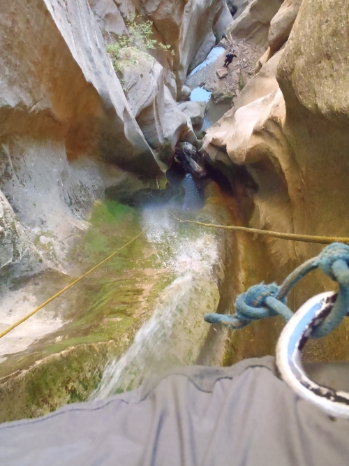
This is a view down while on rap 5. Luke's POV. Note the log and natural arch near the bottom of the rappel.
Rap 6 - near the bottom of rap 5 - anchored LDC from 3 old bolted
hangers and drops about 90 feet over 3 stages.
Rap 7 - at the bottom of rap 6 - anchored from a log and drops about
60 feet over 2 stages.
Rap 8 (dBoundaryR8) is anchored from a log across the floor and
drops about 20 feet.
The few hundred feet down canyon are 3 or 4 downclimbs of about 6 to
8 feet each before reaching the final rappel. Some of the down
climbs are made easer by logs propped up like ladders (these might
wash out one day).
Rap 9 (dBoundaryR9) anchored LDC from 2 bolted hangers (1 old and 1
new) and drops about 60 feet.
From rap 9 it is about 0.5 miles down canyon wide but deep canyon
with a lot of vegetation for about 0.5 miles to the end of Boundary
Canyon where it meets Kolob Creek (yBoundaryBt). The 0.5 miles from
the bottom of the last rappel to the end of Boundary Canyon has a
few minor scrambles over boulders and as you get closer to the end a
couple use trails going RDC up and around a couple larger drops.
The Exit:
After reaching the confluence where Boundary Canyon meets Kolob
Creek (yBoundaryBt), turn right and go south down Kolob Creek.
Travel down Kolob Creek from Boundary Canyon is much like hiking the
narrows but without the people. The walls are high and narrow and
water is flowing so plan on walking in sections of water and
possibly having to wade a couple times. About 1.2 miles down stream
is the start of the MIA Exit. Before getting to the MIA Exit you
will go through a couple sections of very high narrow scenic slots
worth admiration.
The right (west) wall from Boundary to the MIA Exit is high and
sheer. The MIA Exit drainage on the right (west) is the first
drainage you see along the sheer west wall. If you are not paying
attention it is easy to walk right on by the minor and steep looking
MIA Exit drainage. There may be cairns left on large boulders here
to help mark the MIA Exit. But do not count on them being there.
Keep an eye on the right (west) wall on the way down Kolob Creek and
you should easily be able to spot it. Finding this in the dark
would be next to impossible unless you had been there before.
Starting up the MIA Exit:
The MIA drainage joins Kolob Creek from RDC (west) (jMIA-Exit
). The start of the MIA exit leaves Kolob Creek just upstream of a
side drainage and goes up a steep dirt path along the RUC (north)
side of the side drainage. The path up has a few spots of scrambling
up steep dirt ledges.
About 150 feet from Kolob Creek is downclimb (wMIA-RP-01) of about
15 feet down from the steep dirt path and down into the side
drainage at the top of a large rock ledge. Continue west up the
drainage.
A short distance up will be an upclimb / scramble up of about 10
feet working from left to right.
A short distance farther is an impassable dry fall of about 30 feet.
Bypass this tall dry fall on the RUC (north) side up a very steep
dirt slope between bushes and the canyon wall. At the top of the
dirt slope go back down more steep dirt back down into the drainage
above the dry fall you just bypassed. For the standard MIA exit
continue west up the drainage.
At the top of the 30 foot dry fall (wMIA-RP-02) after bypassing on
the RUC (north) side. Continue up canyon between more narrow walls
and a few short easy upclimbs / scrambles before reaching the bottom
of a larger 50 foot dry fall.
Note: At the apex of a steep dirt path bypassing a 30 foot dry fall is
the start of an alternate MIA exit (not recommended but there).
About 180 feet farther is a dry sandy chute / gully (wMIA-RP-03) on
the RUC (north) side about 40 feet before reaching the bottom of a
50 foot Dry fall. If you get to the bottom of the large 50 foot dry
fall, just turn around about 40 feet to find the chute. Bypass the
50 foot dryfall by climbing up the sandy chute / gully. Near the top
is a large log you will need to climb under.
A little over 100 feet farther is the bottom of steep dirt path
(wMIA-RP-04) bypassing a 50 foot dry fall. Go up the steep path
following it for about 400 feet (horizontal feet) up onto a large
saddle.
Note: if you get to the bottom of a 50 foot dry fall, turn back
about 40 feet to the steep sandy chute.
About 300 feet farther the route tops out on a saddle (wMIA-RP-05)
with rocky out croppings on each side you have good views west over
the next section of the exit. From the saddle you can see the Pipe
Springs Canyon (aka MIA Slot) along the wall ahead and to the left
(south) about 500 feet away. To the right of Pipe Springs Canyon is
the final off trail climb of the exit. There used to be a set of 3
dead trees to help identify the top out but 2 of them have since
fallen.
From the saddle follow a path west down moderate slopes and continue
following well worn paths veering left (south) down into a larger
drainage below. Once down in that larger drainage, turn right and
follow the large drainage west along the canyon wall a few hundred
feet up to the bottom of Pipe Springs Canyon (MIA Slot).
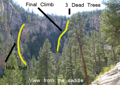
This is a view from the saddle and some labels for what you will be looking for.
NOTE:: As of 2020 there is only one large dead tree
as the other 2 have fallen over.
From the bottom of Pipe Spring Canyon (yPipeSpringBt),
turn left and start
northwest up the
drainage.
About 200 feet farther is a fork (wMIA-RP-06) in drainage as you go
up the MIA Exit. At this fork look to the left (south) of the left fork to
find then follow up a steep use trail up to the west. The trail
roughly follows the side of the left fork of the drainage going up
steep dirt slopes through vegetation. After about 300 feet the use
trails level off slightly and become more easily traveled along the
base of the cliff wall. Once on better trail near the base of the
cliff wall, continue up about 250 more feet to where the trail
crosses over the large drainage you have been roughly following.
Note:
From this fork up to the
dirt roads above is about
650 feet of elevation gain
over about 1000 horizontal
feet.
The first 300 feet is
steep and as of 2020 is
beginning to erode
significantly into sections
of steep soft sand.
As the use trail crosses (wMIA-RP-07) a shelf in the drainage /
ravine to the other side. Looking up from here you will see the
sheer rock wall of the canyon then a prominent rock outcropping
slightly to the right up near the rim. The view may be obscured by
trees so keep an eye out. To the right of the rock out cropping is a
tall dead tree. After crossing the ravine continue west up the steep
hill in thicker vegetation and much less obvious use trail. There is
no one best way up this last 450 feet of steep loose hill side. Be
very careful of loose rock and sandy ledges.
Note: In years past there
used to be 3 tall dead trees
you could see up on the rim,
which made for a great
landmark. As of 2020 two of
the trees have fallen and
there is now just one tall
dead tree making the
landmark less noteworthy.
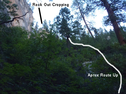
This is a view of the out cropping and the approximate route up the last part of the climb.
Once up on the large well graded dirt road (jMIA-climb/rd) turn left
walking south up the well graded dirt road for about 360 feet to
find an old no longer used road on the right (west).
Note:
There are
multiple ways through the web of roads back to the West Rim
Trailhead. The route described is the most direct route.
Once you find the old not well used road (wMIA-RP-08) going up the
hill to the right (west), turn right and leave the main dirt road
and walk west up the semi steep not well used road.
About 200 feet up the old side road is a bend in the road
(wMIA-RP-09), follow the
bend to the right and
continue north up the road.
About 425 feet farther is another bend in the road
(wMIA-RP-10), follow the bend to the left and travel up the
road to the northwest.
A little over 500 feet farther is a fork in the road (wMIA-RP-11),
stay straight (right) and continue up the road to the northwest. Do
not turn left onto the side road going south.
About 0.2 miles up the road is a junction (wMIA-RP-12),
stay straight (right) and continue up the road to the northwest. Do
not turn left onto the side road going south.
About 0.2 miles up the road is gate nailed to a tree with Top
King welded into it (wMIA-RP-13), continue northwest up the road.
Note:
This gate also
marks the park boundary. To
the west toward the West Rim
Trailhead is in the park.
Another 0.2 miles is a Tee in the road (wMIA-RP-14), turn left
at this tee and start down a hill to the west.
About 500 farther is fork in the road (wMIA-RP-15), continue
straight at this fork passing a road that joins in from the left
(south east).
Continue on the road a little over 1 mile back to the West Rim
Trailhead.
Downloadable GPX files
available at
BG-Gear Store
(easier than manual entry and a great way to support
Bluugnome).
Waypoint naming convention and map symbol information can be found on the Glossary page.
Elevations are approximate.
BEFORE
manually entering coordinates set your system to WGS84 datum and Lat/Lon hddd.ddddd° coordinate format.
Inconsistent datum's and coordinate formats will result in location errors.
Click to show / expand the list of waypoints below........
| Boundary (1) - Drive to Trailhead |
- extKolobRes
Lat/Lon (WGS84): N 37.20374
W -113.18604
Elev: NaN Feet
Turn off for Kolob Reservior Raod.
- tLftFrkNrthCk
Lat/Lon (WGS84): N 37.28480
W -113.09576
Elev: 5,070 Feet
Trailhead for the Left Fork of North Creek trail.
- tWildCatCyn
Lat/Lon (WGS84): N 37.33985
W -113.07587
Elev: 6,970 Feet
Wild Cat Canyon Trailhead.
- extLavaPoint
Lat/Lon (WGS84): N 37.39454
W -113.05287
Elev: 7,898 Feet
Turn off for Lava Point off of the Kolob Reservoir Road.
- tWestRimN
Lat/Lon (WGS84): N 37.38155
W -113.02298
Elev: 7,470 Feet
Northern trailhead for the West Rim Trail (by Lava Point).
|
| Boundary (2) - Approach |
- tWestRimN
Lat/Lon (WGS84): N 37.38155
W -113.02298
Elev: 7,470 Feet
Northern trailhead for the West Rim Trail (by Lava Point).
- wMIAgate
Lat/Lon (WGS84): N 37.38190
W -113.02256
Elev: NaN Feet
MIA Gate. Do not drive past this gate. You may find the gate locked on your return. To go to Pipe Spring or Boundary Canyons, walk east on the dirt road.
- wBoundaryRP-01
Lat/Lon (WGS84): N 37.38560
W -113.01066
Elev: 7,245 Feet
Large white gravel clearing on the left (north) side of the road at the top of a hill in the road.
To go to Pipe Spring Canyon, continue east-ish on the main dirt road.
To go to Boundary Canyon, leave the road to the left (north) at the clearing and follow a faint trail north about 250 feet to a ridge then follow the trail down the ridge.
Note: The trail leaving the road is faint and easily missed if not looking As the trail goes down the ridge it soon drops and joins into an old logging road.
Note: If you get to a major fork in the main road while hiking in then you missed spot to leave the road and will need to turn around and walk back about 1600 feet.
- wBoundaryRP-02
Lat/Lon (WGS84): N 37.38681
W -113.01083
Elev: 7,162 Feet
The use trail meets wider portions of the old logging road. Continue following the old logging road north.
- wBoundaryRP-03
Lat/Lon (WGS84): N 37.38783
W -113.01011
Elev: 7,111 Feet
Small clearing where the logging road appears to dead end in a clearing. At this clearing turn sharp right (south) and follow a path through the bushes a short distance until the road becomes easy to follow again as it goes from south to east.
- wBoundaryRP-04
Lat/Lon (WGS84): N 37.38737
W -113.00879
Elev: 7,057 Feet
Very small clearing. At this small clearing turn left following a path leading north down hill. Do not continue straight on the path to the path continuing slightly uphill to the east.
- wBoundaryRP-05
Lat/Lon (WGS84): N 37.38825
W -113.00884
Elev: 7,006 Feet
Trail junction. Turn right (north east) and follow down a ravine down to the southeast.
- yBoundaryTp
Lat/Lon (WGS84): N 37.39022
W -113.00669
Elev: 6,750 Feet
Top Entry for Boundary Canyon. This is where the route meets a trail that parallels along the upper creek of Boundary Canyon. Turn right and follow the trail east along the RDC (south) side of the creek.
|
| Boundary (3) - The Canyon, |
- yBoundaryTp
Lat/Lon (WGS84): N 37.39022
W -113.00669
Elev: 6,750 Feet
Top Entry for Boundary Canyon. This is where the route meets a trail that parallels along the upper creek of Boundary Canyon. Turn right and follow the trail east along the RDC (south) side of the creek.
- dBoundaryR1-3
Lat/Lon (WGS84): N 37.39192
W -113.00071
Elev: NaN Feet
Boundary Canyon - Raps 1 - 3
Rap 1 - anchored from the tree directly at the head of the slot drops about 90 feet.
Rap 2 - at the bottom of rap 1, anchored from 2 bolted hangers head high on the RDC side and drops about 100 feet over 3 stages.
Rap 3 - near the bottom of rap 2 anchored from a log across the canyon floor and drops about 35 feet. Just after rap 3 is a downclimb of about 8 feet through a rabbit hole under a log then just around the corner is the next rap. If the rabbit hole fills in with debris you can just extend the rope from rap 3 to include the small drop as part of the rappel.
Note: About 50 feet before reaching rap 1 is a tree with a park boundary sign where you leave the park and cross onto BLM land just before reaching the first rappel.
- dBoundaryR4
Lat/Lon (WGS84): N 37.39199
W -113.00018
Elev: NaN Feet
Boundary Canyon - Rap 4 Anchored RDC from 1 (soon to become 2) bolted hanger and drops about 50 feet. About 50 feet down canyon is a narrow downclimb of about 8 feet to the anchors for the next rap.
- dBoundaryR5-7
Lat/Lon (WGS84): N 37.39208
W -112.99994
Elev: NaN Feet
Boundary Canyon - Raps 5 - 6
Rap 5 - Anchored at the bottom of a narrow flute from 2 old bolted hangers LDC and drops about 100 feet down a deeply fluted water fall (if there is flowing water) passing under a natural arch near the bottom. With or without water this is a very pretty rappel.
Rap 6 - near the bottom of rap 5 - anchored LDC from 3 old bolted hangers and drops about 90 feet over 3 stages.
Rap 7 - at the bottom of rap 6 - anchored from a log and drops about 60 feet over 2 stages.
- dBoundaryR8
Lat/Lon (WGS84): N 37.39217
W -112.99972
Elev: NaN Feet
Boundary Canyon - Rap 8. Anchored from a log across the floor and drops about 20 feet.
The few hundred feet down canyon are 3 or 4 downclimbs of about 6 to 8 feet each before reaching the final rappel. Some of the down climbs are made easer by logs propped up like ladders (these might wash out one day).
- dBoundaryR9
Lat/Lon (WGS84): N 37.39276
W -112.99826
Elev: NaN Feet
Rap 9 - Boundary Canyon. Anchored LDC from 2 bolted hangers (1 old and 1 new) and drops about 60 feet.
From rap 9 it is about 0.5 miles down canyon wide but deep canyon with a lot of vegetation for about 0.5 miles to the end of Boundary Canyon where it meets Kolob Creek (yBoundaryBt). The 0.5 miles from the bottom of the last rappel to the end of Boundary Canyon has a few minor scrambles over boulders and as you get closer to the end a couple use trails going RDC up and around a couple larger drops.
- yBoundaryBt
Lat/Lon (WGS84): N 37.39449
W -112.98952
Elev: 5,750 Feet
Bottom exit of Boundary Canyon where it meets Kolob Creek. To go exit, turn right and go south down Kolob Creek.
Travel down Kolob Creek from Boundary Canyon is much like hiking the narrows but without the people. The walls are high and narrow and water is flowing so plan on walking in sections of water and possibly having to wade a couple times. About 1.2 miles down stream is the start of the MIA Exit. Before getting to the MIA Exit you will go through a couple sections of very high narrow scenic slots worth admiration.
The right (west) wall from Boundary to the MIA Exit is high and sheer. The MIA Exit drainage on the right (west) is the first drainage you see along the sheer west wall. If you are not paying attention it is easy to walk right on by the minor and steep looking MIA Exit drainage. There may be cairns left on large boulders here to help mark the MIA Exit. But do not count on them being there. Keep an eye on the right (west) wall on the way down Kolob Creek and you should easily be able to spot it. Finding this in the dark would be next to impossible unless you had been there before.
|
| Boundary (4) - Exit via the MIA Trail |
- yBoundaryBt
Lat/Lon (WGS84): N 37.39449
W -112.98952
Elev: 5,750 Feet
Bottom exit of Boundary Canyon where it meets Kolob Creek. To go exit, turn right and go south down Kolob Creek.
Travel down Kolob Creek from Boundary Canyon is much like hiking the narrows but without the people. The walls are high and narrow and water is flowing so plan on walking in sections of water and possibly having to wade a couple times. About 1.2 miles down stream is the start of the MIA Exit. Before getting to the MIA Exit you will go through a couple sections of very high narrow scenic slots worth admiration.
The right (west) wall from Boundary to the MIA Exit is high and sheer. The MIA Exit drainage on the right (west) is the first drainage you see along the sheer west wall. If you are not paying attention it is easy to walk right on by the minor and steep looking MIA Exit drainage. There may be cairns left on large boulders here to help mark the MIA Exit. But do not count on them being there. Keep an eye on the right (west) wall on the way down Kolob Creek and you should easily be able to spot it. Finding this in the dark would be next to impossible unless you had been there before.
- jMIA-Exit
Lat/Lon (WGS84): N 37.37983
W -112.98219
Elev: 5,590 Feet
MIA Exit leaves Kolob Creek. The start of the MIA exit leaves Kolob Creek just upstream of a side drainage and goes up a steep dirt path along the RUC (north) side of the side drainage. The path up has a few spots of scrambling up steep dirt ledges.
- wMIA-RP-01
Lat/Lon (WGS84): N 37.37929
W -112.98253
Elev: NaN Feet
Downclimb of about 15 feet down from the steep dirt path and down into the side drainage at the top of a large rock ledge. Continue west up the drainage.
A short distance up will be an upclimb / scramble up of about 10 feet working from left to right.
A short distance farther is an impassable dry fall of about 30 feet. Bypass this tall dry fall on the RUC (north) side up a very steep dirt slope between bushes and the canyon wall. At the top of the dirt slope go back down more steep dirt back down into the drainage above the dry fall you just bypassed. For the standard MIA exit continue west up the drainage.
- jMIA-Alt01
Lat/Lon (WGS84): N 37.37922
W -112.98311
Elev: NaN Feet
Apex of a steep dirt path bypassing a 30 foot dry fall.
To follow the MIA standard exit, follow steep dirt back down into the main drainage.
To follow the MIA alternate exit, go up the even steeper dirt path going up from the apex of this dirt bypass path.
- wMIA-RP-02
Lat/Lon (WGS84): N 37.37913
W -112.98319
Elev: NaN Feet
Top of the 30 foot dry fall after bypassing on the RUC (north) side. Continue up canyon between more narrow walls and a few short easy upclimbs / scrambles before reaching the bottom of a larger 50 foot dryfall.
- wMIA-RP-03
Lat/Lon (WGS84): N 37.37900
W -112.98382
Elev: NaN Feet
Dry sandy chute / gully on the RUC (north) side about 40 feet before reaching the bottom of a 50 foot Dry fall. If you get to the bottom of the large 50 foot dry fall, just turn around about 40 feet to find the chute. Bypass the 50 foot dryfall by climbing up the sandy chute / gully. Near the top is a large log you will need to climb under.
- wMIA-RP-04
Lat/Lon (WGS84): N 37.37925
W -112.98428
Elev: NaN Feet
Bottom of steep dirt path bypassing a 50 foot dry fall. Go up the steep path following it for about 400 feet (horizontal feet) up onto a large saddle.
Note: if you get to the bottom of a 50 foot dry fall, turn back about 40 feet to the steep sandy chute.
- wMIA-RP-05
Lat/Lon (WGS84): N 37.37962
W -112.98539
Elev: 5,970 Feet
Route tops out on a saddle with rocky out croppings on each side you have good views west over the next section of the exit. From the saddle you can see the Pipe Springs Canyon (aka MIA Slot) along the wall ahead and to the left (south) about 500 feet away. To the right of Pipe Springs Canyon is the final off trail climb of the exit. There used to be a set of 3 dead trees to help identify the top out but 2 of themhave since fallen.
From the saddle follow a path west down moderate slopes and continue following well worn paths veering left (south) down into a larger drainage below. Once down in that larger drainage, turn right and follow the large drainage west along the canyon wall a few hundred feet up to the bottom of Pipe Springs Canyon (MIA Slot).
- wMIA-RP-051
Lat/Lon (WGS84): N 37.37878
W -112.98579
Elev: 5,870 Feet
Route drops to a larger drainage here. Turn right and follow west up the draiange a few hundred feet to the bottom of Pipe Springs Canyon.
- yPipeSpringBt
Lat/Lon (WGS84): N 37.37914
W -112.98696
Elev: 5,890 Feet
Bottom of the Pipe Spring Canyon..
- wMIA-RP-06
Lat/Lon (WGS84): N 37.37942
W -112.98762
Elev: 5,984 Feet
Fork in drainage as you go up the MIA Exit. At this fork look to the left (south) of the left fork to find then follow up a steep use trail up to the west. The trail roughly follows the side of the left fork of the drainage going up steep dirt slopes through vegetation. After about 300 feet the use trails level off slightly and become more easily traveled along the base of the cliff wall. Once on better trail near the base of the cliff wall, continue up about 250 more feet to where the trail crosses over the large drainage you have been roughly following.
Note:
From this fork up to the dirt roads above is about 650 feet of elevation gain over about 1000 horizontal feet.
The first 300 feet is steep and as of 2020 is beginning to erode significantly into sections of steep soft sand.
- wMIA-RP-07
Lat/Lon (WGS84): N 37.37962
W -112.98922
Elev: 6,238 Feet
Use trail crosses a shelf in the drainage / ravine to the other side. Looking up from here you will see the sheer rock wall of the canyon then a prominent rock outcropping slightly to the right up near the rim. The view may be obscured by trees so keep an eye out. To the right of the rock out cropping is a tall dead tree. After crossing the ravine continue west up the steep hill in thicker vegetation and much less obvious use trail. There is no one best way up this last 450 feet of steep loose hill side. Be very careful of loose rock and sandy ledges.
Note: In years past there used to be 3 tall dead trees you could see up on the rim, which made for a great landmark. As of 2020 two of the trees have fallen and there is now just one tall dead tree making the landmark less noteworthy.
- jMIA-climb/rd
Lat/Lon (WGS84): N 37.38031
W -112.99060
Elev: 6,540 Feet
Junction where the climb up the MIA Exit intersects with a road.
To go to the West Rim Trailhead, turn left walking south up the well graded dirt road for about 360 feet to find an old no longer used road on the right (west).
Note: There are multiple ways through the web of roads back to the West Rim Trailhead. The route described is the most direct route.
- wMIA-RP-08
Lat/Lon (WGS84): N 37.37944
W -112.99105
Elev: NaN Feet
Very faint not well used road droppping down to the main dirt road.
To go to Pipe Spring Canyon, turn right and follow the well graded road down to the southwest.
To go to the West Rim Trailhead, leave the main dirt road and walk west up the semi steep not well used road.
- sPipeSpring
Lat/Lon (WGS84): N 37.37912
W -112.99171
Elev: NaN Feet
Junction in the road with a sign for Lady Bug and Lower Campground. There used to be a pipe with flowing spring water but has since been removed.
To go to Pipe Spring Canyon, follow the road going down to the southeast for about 450 feet to where the road becomes less traveled and fades to trail.
- wMIA-RP-09
Lat/Lon (WGS84): N 37.37972
W -112.99173
Elev: NaN Feet
A bend in the road.
To go to Pipe Spring Canyon, follow the bend the left and continue southeast down the road.
To go to the West Rim Trailhead, follow the bend to the right and continue north up the road.
- wMIA-RP-10
Lat/Lon (WGS84): N 37.38083
W -112.99173
Elev: NaN Feet
Bend in the road.
To go to Pipe Spring Canyon, follow the bend to the right and travel down the road to the south.
To go to the West Rim Trailhead, follow the bend to the left and travel up the road to the northwest.
- wMIA-RP-11
Lat/Lon (WGS84): N 37.38123
W -112.99338
Elev: NaN Feet
Fork in the road.
To go to Pipe Spring Canyon, stay straight (left) and continue down the road to the southeast as the road becomes less traveled. Do not turn right onto the side road going south.
To go to the West Rim Trailhead, stay straight (right) and continue up the road to the northwest. Do not turn left onto the side road going south.
- wMIA-RP-12
Lat/Lon (WGS84): N 37.38206
W -112.99688
Elev: 6,960 Feet
Junction in the road.
To go to Pipe Spring Canyon, stay straight (left) and continue down the road to the southeast. Do not turn right onto the side road going south.
To go to the West Rim Trailhead, stay straight (right) and continue up the road to the northwest. Do not turn left onto the side road going south.
Note: The road to the south from here can be used to go down to Pipe Spring but is longer.
- wMIA-RP-13Gate
Lat/Lon (WGS84): N 37.38306
W -113.00042
Elev: 7,090 Feet
Gate nailed to a tree with Top King welded into it.
To go to Pipe Springs Canyon, continue southeast down the road.
To go to the West Rim Trailhead, continue northwest up the road.
Note: This gate also marks the park boundary. To the west toward the West Rim Trailhead is in the park.
- wMIA-RP-14
Lat/Lon (WGS84): N 37.38471
W -113.00358
Elev: NaN Feet
A Tee in the Road.
To go to Pipe Springs Canyon, turn right at this tee and continue southeast.
To go to the West Rim Trailhead, turn left at this tee and start down a hill to the west.
- wMIA-RP-15
Lat/Lon (WGS84): N 37.38435
W -113.00538
Elev: NaN Feet
Junction in the road.
To go to Pipe Springs Canyon stay left at this fork continuing east.
To go to the West Rim Trailhead, continue straight at this fork passing a road that joins in from the left (south east).
- wBoundaryRP-01
Lat/Lon (WGS84): N 37.38560
W -113.01066
Elev: 7,245 Feet
Large white gravel clearing on the left (north) side of the road at the top of a hill in the road.
To go to Pipe Spring Canyon, continue east-ish on the main dirt road.
To go to Boundary Canyon, leave the road to the left (north) at the clearing and follow a faint trail north about 250 feet to a ridge then follow the trail down the ridge.
Note: The trail leaving the road is faint and easily missed if not looking As the trail goes down the ridge it soon drops and joins into an old logging road.
Note: If you get to a major fork in the main road while hiking in then you missed spot to leave the road and will need to turn around and walk back about 1600 feet.
- wMIAgate
Lat/Lon (WGS84): N 37.38190
W -113.02256
Elev: NaN Feet
MIA Gate. Do not drive past this gate. You may find the gate locked on your return. To go to Pipe Spring or Boundary Canyons, walk east on the dirt road.
- tWestRimN
Lat/Lon (WGS84): N 37.38155
W -113.02298
Elev: 7,470 Feet
Northern trailhead for the West Rim Trail (by Lava Point).
|
| Boundary (5) - Exit down Kolob then Narrows |
- yBoundaryBt
Lat/Lon (WGS84): N 37.39449
W -112.98952
Elev: 5,750 Feet
Bottom exit of Boundary Canyon where it meets Kolob Creek. To go exit, turn right and go south down Kolob Creek.
Travel down Kolob Creek from Boundary Canyon is much like hiking the narrows but without the people. The walls are high and narrow and water is flowing so plan on walking in sections of water and possibly having to wade a couple times. About 1.2 miles down stream is the start of the MIA Exit. Before getting to the MIA Exit you will go through a couple sections of very high narrow scenic slots worth admiration.
The right (west) wall from Boundary to the MIA Exit is high and sheer. The MIA Exit drainage on the right (west) is the first drainage you see along the sheer west wall. If you are not paying attention it is easy to walk right on by the minor and steep looking MIA Exit drainage. There may be cairns left on large boulders here to help mark the MIA Exit. But do not count on them being there. Keep an eye on the right (west) wall on the way down Kolob Creek and you should easily be able to spot it. Finding this in the dark would be next to impossible unless you had been there before.
- jMIA-Exit
Lat/Lon (WGS84): N 37.37983
W -112.98219
Elev: 5,590 Feet
MIA Exit leaves Kolob Creek. The start of the MIA exit leaves Kolob Creek just upstream of a side drainage and goes up a steep dirt path along the RUC (north) side of the side drainage. The path up has a few spots of scrambling up steep dirt ledges.
- dKolobR14
Lat/Lon (WGS84): N 37.37446
W -112.97633
Elev: NaN Feet
Rap 14 - Kolob Creek. Anchored at your feet near the center of the water course from a single bolted aluminum piece. Drops about 15 feet to a pool below which is a swimmer for about 40 feet.
- yKolobCreekBt
Lat/Lon (WGS84): N 37.34941
W -112.95053
Elev: 4,940 Feet
Bottom of Kolob Creek where it meets the Zion Narrows. Labeled as technical since there is one 15 foot rappel between here and the MIA Exit.
- lNarrowCmp08
Lat/Lon (WGS84): N 37.34721
W -112.95225
Elev: NaN Feet
Narrows Camp site 8. This is RDC.
- lNarrowCmp09
Lat/Lon (WGS84): N 37.34419
W -112.95145
Elev: NaN Feet
Narrows Camp site 9. This is LDC and about 60 feet down canyon of where Checkerboard joins the Narrows.
- yGooseCreekBt
Lat/Lon (WGS84): N 37.33845
W -112.95709
Elev: 4,790 Feet
North Fork Virgin River
- yCorralHlwBt
Lat/Lon (WGS84): N 37.33138
W -112.95711
Elev: 4,740 Feet
Bottom exit of Corral hollow where it meets the Narrows just above Big Springs.
- sBigSpring
Lat/Lon (WGS84): N 37.33111
W -112.95688
Elev: NaN Feet
Big Spring
- yImlayBt
Lat/Lon (WGS84): N 37.30986
W -112.94923
Elev: 4,670 Feet
Bottom of Imlay Canyoneering route where it dumps into The Zion Narrows.
- yOrdervilleBt
Lat/Lon (WGS84): N 37.30803
W -112.94661
Elev: 4,670 Feet
Bottom exit of Orderville Canyon.
Junction where Orderville Canyon meets the narrows in the North Fork of the Virgin River. Zion Ntl. Park
- yMysteryBt
Lat/Lon (WGS84): N 37.29928
W -112.94447
Elev: 4,560 Feet
Bottom exit of Mystery Canyon where it meets the Virgin River Narrows after the 120 foot Rap 11.
- jRiverWalkEnd
Lat/Lon (WGS84): N 37.29672
W -112.94818
Elev: 4,560 Feet
This is where the river walk side walk meets the river in The Narrows.
- tNarrowsBot
Lat/Lon (WGS84): N 37.28535
W -112.94785
Elev: 4,440 Feet
Bottom trailhead for the Virgin River Narrows at the Temple of Sinawava.
|