Canyoneering Route Description
Birch Hollow - 3A IV (or III)
Zion National Park, Utah.
07-26-09, 4 people, 1 Day (Travel time in route 12 hours - Exit down
Orderville) (4.6 hours - trailhead to Orderville Jct.)

06-05-10, 5 people, 1 Day (Travel time in route 7 hours - Exit up
Wild Wind Hollow) (3 hours - trailhead to Orderville Jct.)
09-04-11, 7 people, 1 Day (Travel time in route 6.1 hours - Exit up
Wild Wind Hollow) (3.4 hours - trailhead to Orderville Jct.)
10-01-11, 2 people, 1 Day (Travel time in route 4.8 hours - Exit up
Wild Wind Hollow) (2.7 hours - trailhead to Orderville Jct.)
09-24-17, 8 people, 1 Day (Travel time in route 6.5 hours - Exit up
Wild Wind Hollow)
09-12-20, 5 people, 1 Day (Travel time in route
5 hours - Exit up Orderville to Lower parking area)
Exit - - - Down Orderville and the Narrows
Time Required - 10 to 13
Distance - 10.6 miles Total, 0.8 miles Technical
Rappels - 10 Rappels, Longest Rappel 100 feet. (2 extra raps if exiting down Orderville
making a total of 12)
Elevation Range for loop option on foot - 6740
- 5510 Feet
Shuttle Required - Yes 22.1 Miles Vehicle -
Passenger. Rain may require
High Clearance or 4WD
Permit Required - Yes
Exit - - - Up Orderville then Up Wild Wind Hollow
Time Required - 5 to 8
Distance - 4.4 miles Total, 0.8 miles Technical
Rappels - 10 Rappels, Longest Rappel 100 feet.
Elevation Range for loop option on foot - 6820
- 4440 Feet
Shuttle Required - No Vehicle -
Passenger. Rain may require
High Clearance or 4WD
Permit Required - No
Exit - - - Up Orderville to the Upper Orderville
trailhead.
Time Required - xx
Distance - 5.3 miles Total, 0.8 miles Technical
Rappels - 10 Rappels, Longest Rappel 100 feet. (2 extra raps if exiting down Orderville)
Elevation Range for shuttle option - 5510 -
6400 Feet
Shuttle Required - Yes 3.2 Miles Vehicle -
Passenger. Rain may require
High Clearance or 4WD
Permit Required - No
Rappelling and anchor gear, Ropes and or pull cords for rappels up
to 100 feet and 60 feet of 1 inch webbing for sling placement. If
exiting down Orderville Canyon,
wet suits are recommended only if done during cooler months.
The technical
portion of Birch Hollow is deep, narrow and twisty! The lower
portion of Birch Hollow has 10 of the 11 rappels in quick
succession making it fun. The upper part
of the approach down from the top portion of Birch Hollow has one
rappel and could be a muddy mess if done shortly after heavy rains.
There are 3 options for exiting Birch Hollow; Down Orderville then
out the Zion Narrows, Up Orderville to the upper Orderville
trailhead or up Wild Wind Hollow (two drainage east of Birch
Hollow).
If exiting down Orderville Canyon, this
is long day but well worth the time. The lower portion of Orderville has a few treats
in store for you..
Exiting up Orderville to the Upper Orderville Trailhead is not yet included in this route description.
I will add this later when I have the opportunity.
Exiting up Wild Wind Hollow is can be a difficult and frustrating
bushwhacking experience up steep terrain if you don't find a good
route up. Most reports of the Wild Wind Hollow Exit talk about
a horrible experience with bushwhacking. On my first venture
up the Wild Wind Hollow Exit we had a lot of bushwhacking and I
decided I did not want to use the route again. A friend showed
me a route up that she and another friend had stumbled upon.
Combining parts of both our routes turned out to be a pretty easy to
follow route with a few sections of minimal bushwhacking. The
result is a route that does not beat you up (not too much anyway),
is generally easy to follow and eliminates the need for a shuttle.
The
start up Wild Wind Hollow is in a mud flow zone that could be a
complete disaster if the area were wet, so the Wild Wind Hollow exit would only be
advised in dryer months. The bottom of the Wild Wind Hollow
drainage is 0.4 miles upstream (east) in the Orderville drainage
after exiting Birch Hollow.
Note / Warning:
In spring / summer of 2011 the BLM placed a sign at the Birch Hollow
trailhead. The sign states that the recent increase in the use
of Birch Hollow has led to documented impacts to the canyon and the
Mexican Spotted Owl Habitat. The BLM asks the canyoneering
community to limit group sizes to 12 people, pack it in - pack it
out, leave what you find, don't harass the wildlife and keep the
noise down. If the negative impacts continue to effect Birch
Hollow the BLM may institute a permit system. Please try to
follow the rules to avoid Birch Hollow being included in the permit
system.
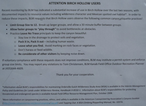
Sign posted by the BLM at the Birch Hollow trailhead.
When you get to the large drop about a mile down canyon of the
trailhead do not use the bypass on the left (southwest) side.
This is a huge negative impact we can avoid. Instead use the
rappel about 200 feet to the right ( northeast) then scramble down
to the canyon floor.
To get to the Trailhead
From the East Gate of Zion National Park, travel 2.4 miles east
on highway 9 to the turn for North Fork Road (wEngDP-01).
Turn left (north)
onto North Fork Road and drive 5.3 miles on a paved road to the
turn for the Ponderosa Ranch (wEngDP-02).
Continue past the turn for the
turn for Ponderosa
Ranch and continue on the North Fork Road a few hundred feet to
where the pavement
ends (wBirchHlwDP-01).
About 2.8 miles after the pavement ends is a large turn
out on the left (west) side of the road with a wooden kiosk. The turnout is
the trailhead for Birch Hollow (tBirchHollow).
To leave the Exit Vehicle / Escape Pod
Exiting down Orderville Canyon to the Narrows:
Leave an exit vehicle at the Zion Visitor center. After the
route take the Zion shuttle back to the visitor center to pick
up the vehicle. Then drive up to retrieve the entry vehicle.
Exiting up canyon to the upper Orderville Canyon
trailhead:
From the Birch Hollow trailhead drive and additional 3.2 miles
up the North Fork Road to the exit for the Upper Orderville
Trailhead (extOrderville). Turn left (west) and drive 0.2
miles to a large dirt parking area just before a gate.
Exiting up canyon to the upper Orderville Canyon
trailhead:
No shuttle required. the route is done as a loop
route.
GPS coordinate information listed at the bottom. For information about waypoint naming and map symbols, refer to the
Glossary page.

Click the links for maps of the route.
Map of the entire route
inc. drive to trailhead.
Map of the technical section
and WWH exit.
The Approach:
From the trailhead / turnout (tBirchHollow) drop into the wash at the north end
of the turnout. There is a well used use trail leading the way. If
the trial was not used frequently this area might involve some
serious bush whacking. The foot traffic through this area appears
to keep a clear path cut through the vegetation. Along the wash are
sections with fallen trees or other obstacles. Most of the time
there is a bypass trail that takes a quick detour up and around it.
About 0.3 miles from the trailhead is a sandy slope on the right
(north) that is white on the top and pink at the bottom. The outer
layer of white sand has washed away from the lower portion of the
slope exposing the pink earth underneath on the lower portion of the
slope (wBirchHlwRp-1).
About 0.6 miles from the trailhead is a wooden ramp made of 4X4
posts (wBirchHlwRp-2). The ramp is on the floor of the wash and has
become part of the trail. After the ramp that canyon gets a bit
wider and has better defined trails.
At 1.1 miles from the trailhead is the top of a large dry water fall
(yBirchHollowTp). The top of the water fall is on the edge of a
huge bowl shaped area and is marked as the start of the Birch Hollow
technical section.
The Canyon / Technical Section:
The drop at of the large dry water fall
(yBirchHollowTp) can be bypassed LDC (southwest). Please
refrain from bypassing the drop this way. Bypassing the route
this way is significantly adding to the erosion process.
Spring / Summer of 2011 BLM posted a sign at the trailhead noting
they were monitoring the impact of the recent increase in use of
Birch Hollow. If the negative impact continues the BLM may
institute a permit system. Please do not bypass the drop down
the social trails on the left.
Rappelling directly down the top of the dray fall is not recommended
since there are a lot of large loose rocks on the wall that can
easily be knocked loose. You may find an anchor tied to the
tree at the top of the drop used by previous parties. This is
not the safest option due to the large loose rocks on the rap.
From the top of the dry fall (yBirchHollowTp)
turn right (east) and follow the rim for about 140 feet over where a
shallow drainage. Where the shallow drainage pours off is rap
1.
Rap 1 (dBrchHlwR1) is anchored from a tree about 6 feet back and
drops about 40 feet down a vertical wall with some loose rock along
the way. From the bottom of rap 1 scramble down to the canyon
floor then continue down canyon.
Rap
2 (dBirchHlwR2) is about 0.4 miles down canyon of rap 1. Rap 2 is anchored from a log about 20 feet up stream from the
rap and drops about 50 feet down a dry fall. A few feet down
the rap is an overhang giving a short free hang section.
Shortly down canyon from rap 2 the canyon begins to narrow and take
on the twisted slot look. Along the way down the narrow sections
are a few easy down climbs before reaching rap 3.
Rap 3 (dBrchHlwR3) is anchored from a choke stone about 20 feet up stream of the
rap. Rap 3 drops about 15 feet.
Rap 4 (dBrchHlwR4-5) is about 700 feet down canyon of rap
3. Rap 4 is about 15
feet dropping down a pile of boulders. Rap 4 could be
considered a down climb by some. With the use of a hand line it is
easier to just down climb then to set up a rap.
Rap 5 is a short distance from rap
4 and is anchored from 2 bolted
hangers LDC. Rap 5 drops about 20 feet. If there have been recent
rains the pool at the bottom of rap 5 may get pretty large but
should not get deep enough to need to swim.
After rap 5 the canyon opens briefly with lots of trees along the
way. After about 500 feet of open canyon there is a sudden drop in
the water course which is rap 6.
Orderville canyon is only 350 feet away but there are still 6 more
rappels to get there. This section is short but fun as it is in a
deep, tight twisted section of canyon and feels like it is rap after
rap.
Rap 6 (dBrchHlwR6-8) is anchored from a tree LDC and drops about 100 feet down into
a tight section of canyon. Rap 6 follows down a dry water fall
along a soft round fluted wall. Rap 6 is the longest rap on the
route.
The total drop is actually about 90 feet but is a total of 11 feet
from the tree anchor over to the rim then down to the floor.
Rap 7 is only a few feet from the bottom of rap 6. Rap 7 is
anchored from 2 bolted hangers RDC and drops about 30 feet.
Rap 8 is only a few feet from the bottom of rap 7. Rap 8 is
anchored from 2 bolt and hangers RDC and drops about 40 feet.
Rap 9 (dBrchHlwR9-11) is about 300 feet down canyon of rap 8 with a
down climb over some boulders between. Rap 9 is anchored from 2 bolt
and hangers RDC and drops about 30 feet. At the top of rap 9
is a choke stone boulder. It is possible for taller people to
slide down between the boulder and the RDC wall and reach out with
their feet to the other wall allowing this rap top be down climbed.
Rap 10 is only a few feet from the bottom of rap 9. Rap 10 is
anchored from 2 bolted hangers LDC and drops about 70 feet down a
fluted wall with a large round chock stone wedge high above. From the top of rap
10 it looks like it drops into a pit with no place to go once at the
bottom. After rapping down you can look around a very tight corner
to see the continuation of the canyon. Looking up from the
bottom of rap 10 is a a scenic treat with the twisted canyon walls
and the large choke stone high overhead.
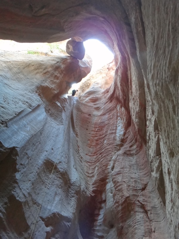
View up rap 10 with the choke stone overhead.
Rap 11 is only a few feet from the bottom of rap 10. Rap 11 is
anchored LDC from 2 bolted hangers and drops about 60 feet. While
looking up rap 11 you still have a good view of that round choke
stone way over head.
After rap 11 it is about 100 feet around a corner to the junction of Orderville Canyon (yBirchHollowBt).
The Exit:
After getting to the bottom of Birch Hollow / the junction of Birch
and Orderville (yBirchHollowBt) there are three options for exiting.
Option One - - Up Wild Wind Hollow
Exiting up Wild Wind Hollow is nice since it keeps the day short and
eliminates the need for a shuttle. The start up Wild Wind
Hollow can be a muddy mess if the area is wet.
From the junction with Orderville (yBirchHollowBt) turn right (west)
and start up Orderville Canyon.
About 0.2 miles up canyon will be a drainage joining in from the
right (south). Continue up canyon past this drainage.
About 0.25 miles farther (or 0.45 miles up canyon from the Birch
Orderville junction) is the Wild Wind Hollow Drainage (tWildWindHlwBt)
joining in from the right (south). Do not travel all the way
to the center of the drainage. Instead find a convenient place
to scramble up the mud flow on the southwest side of the Wild Wind
Hollow drainage.
There are use trails up through this mud flow area that can be
followed up the RUC (southwest) side of Wild Wind Hollow.
About 650 feet up out of Orderville the trail along the mud flow
leads up to the base of a vertical rock cliff band (w-WWH-RP-01).
Continue east on the trail as it follows along the base of the
vertical cliff band.
About 350 feet farther the rock cliff band ends (w-WWH-RP-02).
As the cliff band ends there will still be a well defined trail
traversing the slope about 200 feet up out of the center of Wild
Wind Hollow.
About 200 feet after the cliff band ends will be a junction of
trails (w-WWH-RP-03). Some trails lead down toward a large
flat area that looks like it might be inviting to camp at. Do
not follow this trail. Instead turn right (southwest) and
follow the well worn path leading up the slope away from Wild Wind
Hollow. The trail will lead up into and through a more
forested area.
A little over 300 feet farther, the trail will top out (w-WWH-RP-04)
shortly before reaching a wide shallow drainage. Walk about 50
feet over to the drainage and follow a faint path southwest up the
LUC side of the wide shallow drainage. The path is covered in
pine needles slightly camouflaging it.
Note:
There are many game trails through the area that will get you where
you want to go or lead into sections of bushwhacking. As you
follow up along side the shallow drainage here stay on the game
trails following close to the middle of the drainage. Other
trails here will veer off left (south). It is more difficult
to describe where to go on those routes. To keep the
description here simple to follow stay on the paths slightly left of
the middle of the drainage.
About 500 feet farther, the shallow drainage fades away (w-WWH-RP-05)
and you will be just traversing southwest along the a slope.
Continue southwest about 300 feet traversing up the slope to the
crest of a ridge (w-WWH-RP-06). This ride is the east rim of
the drainage between Wild Wind Hollow and Orderville.
Note:
It is possible to go from (w-WWH-RP-06) to (w-WWH-RP-11) by
traveling southeast up the ridge line. Doing this can shave
about 0.2 miles off the route but will involve heavier vegetation
and possible heavy bushwhacking if you choose your path wrong.
This short cut is too convoluted to describe so I don't try to.
If you wish to cut off some distance but possibly add a little
bushwhacking to your day the ridge between these two points does
work but you gotta push and think your way through a little.
Turn left (south) and travel up the ridge. About 150 feet up
the ridge will be a large flat area and start working over toward
the now obvious head of the large drainage.
About 500 feet after the wide spot on the ridge will be the first
(w-WWH-RP-07) of a few minor washes dropping into the head of the
large drainage.
After crossing the small wash follow the trail that travels around
the head of the large drainage and crossing over a few small washes
dropping into the large drainage. About 400 feet after
crossing the first wash look for a slope going up to the west just
after crossing one of the small washes (w-WWH-RP-08).
Continue west then southwest for about 350 feet up to a saddle
(w-WWH-RP-09). This saddle is on the east rim of Birch Hollow
and is in a forested area so you can't look down into Birch yet.
Turn left and travel southeast up the ridge. There are no well
defined paths here. You will find the occasional use trail but
none seem to go very far. You will need to route find your way
up the ridge with some very minor bush whacking in spots.
About 400 feet up the ridge is a highpoint (w-WWH-RP-10).
Continue east about 600 feet crossing a saddle then back up to
another high point (w-WWH-RP-11).
From the highpoint (w-WWH-RP-11) turn right (south) and continue up
the ridge. From this point you will begin to get intermittent
paths and travel begins to entail simpler route finding with a few
spots of minor bushwhacking. From here it is a straight shot
southeast along the ridge back to the road about 0.7 miles away.
About 0.4 miles farther will be another high point (w-WWH-RP-12) on
the ridge. Continue southwest down over a saddle then up the
ridge. As you cross the saddle there will be some easy to
follow trails leading toward the road about 0.3 miles away.
After getting to the road turn right (south) and walk about 0.3
miles back to the trailhead (tBirchHollow).
Option Two - - Down Orderville to the Virgin River Narrows
Exiting down Orderville to the Narrows is makes for a long day but
well worth the scenic treat and adds 2 short additional rappels.
Traveling down Orderville is a very scenic area, especially as you
get closer to the Zion Narrows.
To exit the canyon, turn left (west) and travel down canyon Orderville
Canyon to the Zion Narrows.
About 2 miles down canyon from Birch Hollow is rap 1 in Orderville.
Orderville Rap 1 is anchored from 2 bolted hangers RDC and drops
about 15 feet into a pool which can sometimes be a muddy mess.
After Orderville rap 1 the narrow sections become more frequent and
longer. There is also more water and frequent down climbs. I like
the lower section of Orderville more that the upper section. It is
more scenic and offers more obstacles.
About 0.3 miles down canyon of Orderville rap 1 is the
junction with Englestead Canyon which joins in from LDC.
About 1.2 miles down canyon of Englestead Canyon is the junction to
Mis-Me Canyon. This is the 3rd drainage on the LDC side after
Englestead.
About 0.9 miles down canyon of Mis-Me Canyon is Orderville Rap 2
which is about 2.4 miles down canyon of Orderville rap 1.
Rap 2 in Orderville has a huge (house sized) choke stone overhead
that has a tree and bushes growing on it. The rappel drops about 12
feet to a pool below and is anchored from 2 bolted hangers LDC.
This is one of my favorite rappels. It is short but has very high
wow factor with the huge rock over head and the pool below. It is
just very pretty.
Down canyon from rap 2 in Orderville the canyon has more and more
water. The further down canyon you go the more the water is
flowing. This is some of the best scenery in Orderville.
There are also more down climbs. One of the down climbs drops into
a pool that requires about a 30 foot swim.
About 1 mile below Orderville rap 2 is the junction with the Zion
Narrows.
From the Narrows junction turn left (south) and travel 1.4
miles down the narrows to the steps leading to the sidewalk.
Follow the sidewalk another 1 mile to the Temple of Sinawava
Shuttle stop. From there it is a shuttle ride back to the visitor
center. Pick up your vehicle there to go get the vehicle left at
the Birch Hollow trailhead.
Option Three - - Up Orderville to the Upper Orderville
Trailhead.
This route has not been added yet.
Downloadable GPX files
available at
BG-Gear Store
(easier than manual entry and a great way to support
Bluugnome).
Waypoint naming convention and map symbol information can be found on the Glossary page.
Elevations are approximate.
BEFORE
manually entering coordinates set your system to WGS84 datum and Lat/Lon hddd.ddddd° coordinate format.
Inconsistent datum's and coordinate formats will result in location errors.
Click to show / expand the list of waypoints below........
| Birch Hollow (1) - Drive to Trailhead |
- wEngDP-01
Lat/Lon (WGS84): N 37.23934
W -112.83230
Elev: 5,869 Feet
Turn to the North Fork off Highway 9.
- wEngDP-02
Lat/Lon (WGS84): N 37.27285
W -112.87304
Elev: NaN Feet
Turn left, to the Ponderosa Ranch.
- wBirchHlwDP-01
Lat/Lon (WGS84): N 37.27620
W -112.87358
Elev: NaN Feet
Paved road turns to Dirt road.
- wBirchHlwDP-02
Lat/Lon (WGS84): N 37.30654
W -112.86085
Elev: NaN Feet
Dirt road / ATV trail leaves main road. Follow this to start an alternate route into Birch Hollow.
- tBirchHollow
Lat/Lon (WGS84): N 37.30973
W -112.85655
Elev: 6,740 Feet
Trailhead for Birch Hollow. It is a very large turn out on the west side of the road.
|
| Birch Hollow (2) - Drive from trailhead to upper exit (optional). |
- tBirchHollow
Lat/Lon (WGS84): N 37.30973
W -112.85655
Elev: 6,740 Feet
Trailhead for Birch Hollow. It is a very large turn out on the west side of the road.
- extOrderville
Lat/Lon (WGS84): N 37.33710
W -112.83050
Elev: NaN Feet
Turn off for Orderville from the North Fork road. 11.4 miles from highway 9.
- tOrdervilleTp
Lat/Lon (WGS84): N 37.33527
W -112.83343
Elev: 6,400 Feet
Trailhead for upper Orderville Canyon. There is a gate here and room to camp for a few cars.
- pkOrdrvlUprAlt
Lat/Lon (WGS84): N 37.33239
W -112.86321
Elev: 5,760 Feet
A large turn out to park in IF you have 4WD to drive in. Otherwise you need to hike this portion of the Orderville route.
|
| Birch Hollow (3) - The Canyon, |
- tBirchHollow
Lat/Lon (WGS84): N 37.30973
W -112.85655
Elev: 6,740 Feet
Trailhead for Birch Hollow. It is a very large turn out on the west side of the road.
- wBirchHlwRP-1
Lat/Lon (WGS84): N 37.31139
W -112.86100
Elev: NaN Feet
Sandy slopes on the right (north) where The outer layer of white sand has washed away from the lower portion of the slope exposing the pink earth underneath on the lower portion of the slope.
- wBirchHlwRP-2
Lat/Lon (WGS84): N 37.31242
W -112.86492
Elev: 6,370 Feet
An old ramp made of 4X4's laying in the wash.
- yBirchHollowTp
Lat/Lon (WGS84): N 37.31493
W -112.87035
Elev: 6,140 Feet
Marked as the top of the technical portion of Birch Hollow.
The wash comes to a dry fall drop off. This is the edge of a huge bowl shaped area.
- dBrchHlwR1
Lat/Lon (WGS84): N 37.31526
W -112.87004
Elev: NaN Feet
Rap 1 in Birch Hollow. Anchored from a tree about 6 feet back and drops about 40 feet down a vertical wall with some loose rock.
- dBrchHlwR2
Lat/Lon (WGS84): N 37.31843
W -112.87454
Elev: NaN Feet
Rap 2 in Birch Hollow.
Anchored from a log about 20 feet upstream of the rap and drops about 50 feet.
- dBrchHlwR3
Lat/Lon (WGS84): N 37.32013
W -112.87542
Elev: NaN Feet
Rap 3 in Birch Hollow. Anchored from a choke stone about 20 feet upstream of the rap and drops about 15 feet.
- dBrchHlwR4-5
Lat/Lon (WGS84): N 37.32082
W -112.87615
Elev: NaN Feet
Raps 4 and 5 in Birch Hollow.
Rap 4 is drops about 15 feet down a pile of boulders and is easily down climbed with the use of a hand line.
Rap 3 is anchored 2 bolted hangers LDC and drops about 20 feet.
- dBrchHlwR6-8
Lat/Lon (WGS84): N 37.32242
W -112.87586
Elev: NaN Feet
Raps 6 - 8 in Birch Hollow.
Rap 6 is anchored from a tree LDC and drops about 100 feet down a fluted dry fall.
Rap 7 is at the bottom of rap 6 and is anchored from 2 bolted hangers RDC and drops about 30 feet.
Rap 8 is anchored from 2 bolt ad hangers RDC and drops about 40 feet.
- dBrchHlwR9-11
Lat/Lon (WGS84): N 37.32297
W -112.87607
Elev: NaN Feet
Raps 9 - 11 in Birch Hollow.
Rap 9 is anchored RDC from 2 bolted hangers and drops about 30 feet.
Rap 10 is anchored LDC from 2 bolted hangers and drops about 70 feet.
Rap 11 is anchored LDC from 2 bolted hangers ad drops about 60 feet.
- yBirchHollowBt
Lat/Lon (WGS84): N 37.32337
W -112.87600
Elev: 5,510 Feet
Bottom Exit of Birch Hollow where it meets Orderville Canyon / Gulch.
|
| Birch Hollow (4) - Exit - To upper Orderville option. |
- yBirchHollowBt
Lat/Lon (WGS84): N 37.32337
W -112.87600
Elev: 5,510 Feet
Bottom Exit of Birch Hollow where it meets Orderville Canyon / Gulch.
- tWildWindHlwBt
Lat/Lon (WGS84): N 37.32445
W -112.87040
Elev: 5,535 Feet
Bottom of Wild Wind Hollow. A non technical and brush filled hollow leading up out of Orederville sometimes used as a return route after Birch Hollow.
- pkOrdrvlUprAlt
Lat/Lon (WGS84): N 37.33239
W -112.86321
Elev: 5,760 Feet
A large turn out to park in IF you have 4WD to drive in. Otherwise you need to hike this portion of the Orderville route.
|
| Birch Hollow (5) - Exit - Wild Wind Hollow option |
- yBirchHollowBt
Lat/Lon (WGS84): N 37.32337
W -112.87600
Elev: 5,510 Feet
Bottom Exit of Birch Hollow where it meets Orderville Canyon / Gulch.
- tWildWindHlwBt
Lat/Lon (WGS84): N 37.32445
W -112.87040
Elev: 5,535 Feet
Bottom of Wild Wind Hollow. A non technical and brush filled hollow leading up out of Orederville sometimes used as a return route after Birch Hollow.
- w-WWH-RP-01
Lat/Lon (WGS84): N 37.32339
W -112.86858
Elev: 5,750 Feet
Trail is better defined and runs at the base of a vertical rock cliff band.
- w-WWH-RP-02
Lat/Lon (WGS84): N 37.32286
W -112.86749
Elev: NaN Feet
Social trail had been following along the base of a sandstone wall. This is the east end of the wall and is about 200 feet up out of the wash.
- w-WWH-RP-03
Lat/Lon (WGS84): N 37.32244
W -112.86703
Elev: 5,840 Feet
Use trail forks off in 3 directions. Turn right (southwest) and follow the trail going up the slope away from Wild Wind Hollow.
- w-WWH-RP-04
Lat/Lon (WGS84): N 37.32176
W -112.86751
Elev: 5,960 Feet
Trail tops out here about 50 feet before reaching a wide shallow drainage. Walk over to the shallow drainge then follow up a faint path along the LUC side.
- w-WWH-RP-05
Lat/Lon (WGS84): N 37.32107
W -112.86916
Elev: NaN Feet
Shallow drainge fades away here and you will be walking southwest traversing the slope.
- w-WWH-RP-06
Lat/Lon (WGS84): N 37.32045
W -112.86989
Elev: 6,085 Feet
Route gets to a ridge that is the east rim of the drainage between Wild Wind hollow and Orderville. Turn left and travel on faint use trails along the ridge.
- w-WWH-RP-07
Lat/Lon (WGS84): N 37.31894
W -112.86949
Elev: 6,155 Feet
First of a few small washes dropping into the head of the large drainge.
- w-WWH-RP-08
Lat/Lon (WGS84): N 37.31869
W -112.87075
Elev: 6,155 Feet
Scramble west up the slope here after crossing over one of the washes dropping into the head of the large draiange.
- w-WWH-RP-09
Lat/Lon (WGS84): N 37.31802
W -112.87146
Elev: 6,245 Feet
Saddle on the ridge. The ridge is on the east rim of Birch Hollow.
- w-WWH-RP-10
Lat/Lon (WGS84): N 37.31746
W -112.87022
Elev: 6,345 Feet
High point along the ridge.
- w-WWH-RP-11
Lat/Lon (WGS84): N 37.31757
W -112.86776
Elev: 6,380 Feet
Another highpoint on the ridge. Trun right (southeast) and continue up the ridge.
- w-WWH-RP-12
Lat/Lon (WGS84): N 37.31395
W -112.86299
Elev: 6,665 Feet
Highpoint on the ridge.
- tBirchHollow
Lat/Lon (WGS84): N 37.30973
W -112.85655
Elev: 6,740 Feet
Trailhead for Birch Hollow. It is a very large turn out on the west side of the road.
|
| Birch Hollow (6) - Exit - Down Orderville option |
- yBirchHollowBt
Lat/Lon (WGS84): N 37.32337
W -112.87600
Elev: 5,510 Feet
Bottom Exit of Birch Hollow where it meets Orderville Canyon / Gulch.
- dOrderVileR1
Lat/Lon (WGS84): N 37.31601
W -112.90229
Elev: 5,240 Feet
Rap 1 in Orderville Canyon. Drops about 15 feet to a pool that is sometimes a muddy mess and is anchored from 2 bolted hangers RDC.
- yEngleSteadBt
Lat/Lon (WGS84): N 37.31461
W -112.90599
Elev: 5,140 Feet
Bottom Of Englestead Canyon where it meets Orderville Canyon.
- yMis-MeBt
Lat/Lon (WGS84): N 37.31230
W -112.92319
Elev: 4,960 Feet
Bottom exit of Mis-Me Canyon where it joins Orderville Canyon.
- dOrderVileR2
Lat/Lon (WGS84): N 37.31167
W -112.93784
Elev: 4,820 Feet
Rap 2 in Orderville Canyon.
Drops about12 feet anchored from 2 bolt and hangars LDC. The pool has a waterfall. There is a huge boulder overhead with tree growing on top. One of my favorite rappels.
This is sometimes called the Guillotine due to the huge boulder chock stone over head.
- yOrdervilleBt
Lat/Lon (WGS84): N 37.30803
W -112.94661
Elev: 4,670 Feet
Bottom exit of Orderville Canyon.
Junction where Orderville Canyon meets the narrows in the North Fork of the Virgin River. Zion Ntl. Park
- yMysteryBt
Lat/Lon (WGS84): N 37.29928
W -112.94447
Elev: 4,560 Feet
Bottom exit of Mystery Canyon where it meets the Virgin River Narrows after the 120 foot Rap 11.
- jRiverWalkEnd
Lat/Lon (WGS84): N 37.29672
W -112.94818
Elev: 4,560 Feet
This is where the river walk side walk meets the river in The Narrows.
- tNarrowsBot
Lat/Lon (WGS84): N 37.28535
W -112.94785
Elev: 4,440 Feet
Bottom trailhead for the Virgin River Narrows at the Temple of Sinawava.
|