Canyoneering Route Description
Redemption Canyon - 4B IV or V
Swett Creek area, Utah
09-19-15, 5 people, 1 Day (Travel time in route 12 hours)
 Time is camp to camp at Hoskinnini Monument and for a side trip.
Time Required - 8 to 10 hours round trip from
Hoskinnini Monument.
Add 5 hours each way for the backpack
to and from Hoskinnini.
Distance for canyon route - 4.2 miles Total,
2.3 miles Technical
Distance for hike in from highway - 5.9 miles
Rappels - 8 Rappels, Longest Rappel 70 feet.
But ropes up to 100 feet will be needed due to anchor
placements.
Elevation Range for canyon route - 3800 - 5200 Feet
for the canyon route itself.
Elevation Range for hike in from highway - 4800
to 3800 Feet.
Shuttle Required - No Vehicle - Passenger
Permit Required - No
Rappelling and anchor gear for rappels up to 100 feet. Max rap
is only 70 feet but due to some anchor placements you will need
ropes up to 100 feet long. 30 feet of webbing just in case you
need it, but try to leave no trace if possible. Smooth
Operator or other retrievable anchor. Sandtrap and or
watertrap will be needed in a couple places depending on conditions.
If you have a JellyFish anchor it can save some time and hassle at
rap 2 but you can also do this with a watertrap or pack drag anchor.
A couple potshots should be on hand just incase the need arises but
you likely will not need them.
Wet suits may not be needed in warm and hot weather but should
be along for cooler days or if you get cold easily.
Looking over maps and Google Earth in early 2012 I had my
eye on a canyon by Hoskinnini Monument and later found out a few others were
wanting to go to the same place. Some groups have been doing this canyon
by using a boat and hiking up to it from Lake Powell. Using a boat to get
to canyons is a little out of my budget, so getting there on my own two feet was
the ticket. We went in by land setting up a basecamp, since
it is such a long way out there. A fast efficient group could likely day
trip Redemption Canyon via land but it would be an extremely long day and is
likely best done by making a back pack trip out of it.
There is a spring in Swett Creek about 3 miles upstream
of Redemption and another spring that is about 800 feet up from Swett Creek
in the bottom of the Redemption drainage. Both appear to be year
round. With the spring in the bottom of redemption being an easy walk
up from Swett Creek it makes it easy to set a base camp in Swett Creek near
the end of Redemption by Hoskinnini Monument.
The general character of Redemption is a mix of short
slots and open vegetated sections of canyon to walk. There are a few
alcove hanging garden like rappels at the end of a few of the slot sections.
Since so many canyons seem to end with this style of alcove hanging garden
rappel, it is easy to keep thinking you are almost done with Redemption when
you get to one of these rappels. There are also some sections of deep
feeling slot with some potholes to play through in the mid to lower portions
of the canyon.
There is one spot in the canyon (wRedempRP-20) where
you will downclimb about 15 feet to a pothole below. The narrow slot
exit of the pothole is too narrow for a person and is easy to get over with
a partner assist if the pool is sand filled and shallow. However if
the pothole has the sand washed out and becomes a swimmer this may be work
to get out of and you will need to get creative to figure out how to get
out. The exit slot is too narrow for a person to fit in near the
bottom so you have to go up about 3 feet to get over the narrow spot but the
narrow spot is severely overhung so climbing up a rope on a potshot would
not allow a climb out since you would be pulled into a crack you do not fit
in. Generally this should not be an issue with a partner assist but
this can change and if it does it will be difficult.
Below rap 3 we have called it the poison alcove due to
mass quantities of poison ivy growing well over 5 feet tall. This is
the most poison ivy I have seen in one spot and it is all VERY healthy and
everywhere. If you use the first large boulder on the RDC ledge you
can avoid it. If you use other anchors you will very likely rappel
down into thick patches of poison ivy...... You Have Been Warned!
Redemption Canyon has traditionally been done as a
ghosted canyon. Please try to maintain the local ethic and leave no
trace if possible. Even though Redemption has traditionally ghosted
the final rap has had webbing left at it since it is difficult to ghost.
The choke stone anchor at the final rap creates a V shaped groove that will
stick a rope when pulled through it. On our visit we were able to cut
the webbing out and use the Smooth Operator V Groove Technique to overcome
this obstacle and ghost the final rappel. Depending on the skill set
of the previous party you may or may not fine webbing left on the choke
stone of the final rap.
Redemption Canyon is one of those places that has a
little bit of everything and I do mean a little bit. Downclimbs,
potholes, stemming, elevators, swims, awkward starts, and a few large
patches of poison ivy. Since Redemption has only a little bit of each
thing and is so far out, I would not put it high on my list of places to get
to by land. However it is worth doing at least once just to see this
place as it does have some pretty cool and unique spots.
To get to the Trailhead
From the Junction of highway 95 and highway 276 (about 26 miles
south of Hanksville Utah) drive south on highway 276 for 13
miles to a turn out on the right (west) side of the road with a large sign titled Mount Hillers
where you will start the route (pkMountHillers).
To leave the Exit Vehicle / Escape Pod
No exit vehicle is needed. This is done as an out and back
trip.
GPS coordinate information listed at the bottom. For information about waypoint naming and map symbols, refer to the
Glossary page.

Click the links for maps of the route.
Map of the entire route.
Map of route up from Swett Creek and down Redemption.
The Approach:
From
the parking area (pkMountHillers) walk across the highway and
continue east into the desert. Walk across the desert and
route find your way east for about 0.6 miles to a gently sloped rim
(wWoodyRP-01) with a view east over a small valley like area full of
light colored sandstone.
From the rim continue
east down into the light
colored sandstone about
800 feet to where a
shallow drainage starts
running down
(wRedempRP-01) to the
south east down into
Swett Creek.
Follow the shallow
drainage southeast about
900 feet down into Swett
Creek. Just as you
get to Swett Creek
(wRedempRP-02) you will
need to downclimb about
15 feet down a steep
portion of slickrock to
get to the floor of
Swett.
Turn left to walk east
down Swett Creek.
About 1.4 miles down
Swett Creek will be a
small canyon / drainage
dropping in from the RDC
side (wRedempRP-03) with
a boulder debris field
about 500 feet before
getting there.
About 0.4 miles farther
is a very large side
canyon / drainage
(wRedempRP-04) dropping
in from the RDC side.
This is just before
getting to a spring fed
section of Swett Creek.
A couple hundred feet
farther is a spring fed
area of Swett Creek
(SwettSpng1). This
appears to be a year
round spring and is a
good source of water but
it does smell and taste
like sulfur.
About 1 mile farther
down canyon
(wRedempRP-05) a short
section of canyon with
downclimb of about 6
feet over some
boulders then a little
farther down canyon is a
larger drop of about 10
feet with a pool at the
bottom that can be waist
to chest deep if full.
We have been able to
downclimb then bridge
over the pool but this
is tricky and you may be
wet anyway. On the
way up this would be a
difficult spot to climb
back up if you were solo
but would not be much of
an issue with a partner
assist to help each
other up.
About 1 mile farther is
a large side drainage
(wRedempRP-06) coming in
on the RDC (south) side.
About 0.7 miles farther
is another side drainage
(wRedempRP-07) coming in
on the RDC (south) side.
Another possible
approach up to
Redemption would be to
travel up the ridge on
the RUC (west) side of
this drainage and see if
you can find a way up to
the rim or it may be
possible to go right up
the drainage to the rim.
These thoughts are from
looking at Google Earth
and may not prove to be
accurate.
About 0.31 miles farther
is where you will begin
your ascent (jRedempSwett)
up out of Swett Creek to
go up to Redemption.
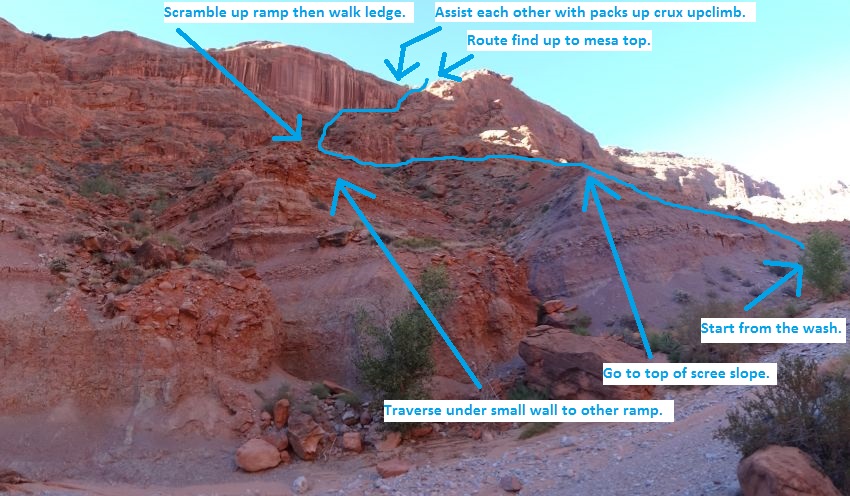
From the bottom of the
ascent route work your
way up the lighter
colored scree pile on
the up canyon side.
From the top of the
scree pile traverse left
working your way under a
small wall then over to
a ramp like area to
scramble up through some
rocky stuff.
Follow the ledge and a
couple easy scrambles to
the right over to the
bottom of the crux
upclimb of the ascent,
then route find your way
up to the mesa top.
The crux upclimb is
about 12 feet in a crack
like portion of a hueco
like feature.
The total elevation gain
of the ascent to the
mesa top is about 750
feet.
Note:
The ascent up out of
Swett Creek is about 0.7
miles west / upstream of
where the bottom of
Redemption drops into
Swett Creek by
Hoskinnini Monument and
is not super obvious
unless you know what to
look for. If you
are hiking in by land it
is easy to miss the
start of the ascent
route since you get to
it before reaching
Hoskinnini Monument.
If you are hiking up
from Lake Powell it is
easier to find since
Hoskinnini Monument is
prominent landmark and
you know to start
looking for the ascent
route about 0.7 miles up
Swett Creek.
 A GPS may be helpful for
getting you to the
correct spot to begin
the ascent out of Swett
since there is no
prominent landmark.
Use this picture to
identify the ascent
route which also
indicates the route up.
A GPS may be helpful for
getting you to the
correct spot to begin
the ascent out of Swett
since there is no
prominent landmark.
Use this picture to
identify the ascent
route which also
indicates the route up.
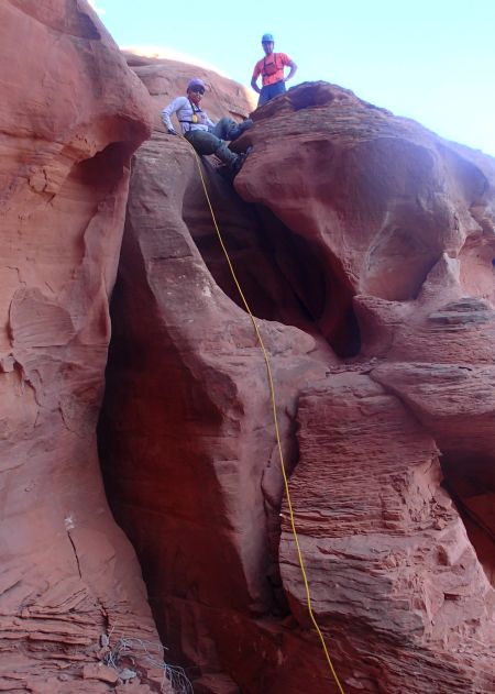 The crux upclimb of the
ascent out of Swett
Creek.
The crux upclimb of the
ascent out of Swett
Creek.
From where the ascent
route gets up to the
mesa top (wRedempRP-08)
route find your way
southwest about 0.2
miles until you get to
the rim of a side fork
of Redemption
(wRedempRP-09).
When you hit the rim of
the side fork
(wRedempRP-09) veer
right to follow the rim
up to the west for about
0.3 miles to where you
can go around the head
of the side drainage
where a ridge is running
up to the southwest
(wRedempRP-10).
Follow the ridge up to
the southwest for about
0.35 miles to where you
are on a rim
(wRedempRP-11) looking
down into the upper
portions of Redemption
Canyon. Veer right
and follow the rim up to
the west / southwest.
About 0.15 miles farther
along the rim contour
around the head
(wRedempRP-12) of a
small side drainage.
About 800 feet farther
along the rim is a
boulder area where you
will need to scramble up
and over to continue up
along the rim
(wRedempRP-13).
About 800 feet farther
the slopes down into
Redemption get more
gentle (wRedempRP-14).
Route find your way down
into Redemption in a
wide open gently sloped
slickrock drainage (yRedempTp).
The Canyoneering / Technical Section:
From the head of
Redemption (yRedempTp)
Between here and rap 1
are a few small potholes
and a couple short drops
you can easily walk
around bypassing on the
sides. Rap 1 is
about 0.3 miles down
canyon with a few small
drops along the way that
can be easily bypassed.
Rap 1 (dRedempR1) drops
about 45 feet, is
anchored using a
sandtrap, has an awkward
start at the top due to
a small overhang and has
a pot hole mid way down
you can step over.
Optionally you could
farm rocks to make a
cairn or dead man
anchor.
Just down canyon of rap
1 is a thigh deep pool
to scramble a few feet
down to which can be
avoided if you have the
skill to traverse the
LDC side with very few
features. After
the pool is open
vegetated wash to walk
for about 350 feet
to a drop 6 feet to a
pool that can easily be
bypassed on the RDC side
(wRedempRP-15).
About 275 feet down
canyon are two drops to
downclimb
(wRedempRP-16).
The first one is about 6
feet and is a moderate
downclimb. The
second one is about 50
feet down canyon and
drops about 10 feet and
will likely need a good
partner assist to get
down. This second
drop has the features
that will allow a good
climber to downclimb it
but the holds are
difficult to see and a
spotter from the bottom
is very helpful.
Rap 2 is about 400 feet
down canyon of here.
Rap 2 (dRedempR2) drops
about 45 feet with a
pothole near the top to
step over and can be
anchored using a
JellyFish anchor or a
choke stone anchor set
at the top in a crack
about 10 feet back from
the drop.
Optionally you can use a
water trap or do a pack
drag anchor from a
pothole just down from
the top of the drop but
this may be awkward.
About 200 feet down
canyon of rap 2 is
boulder debris to climb
over or down under
(wRedempRP-17).
Down canyon of here is
some light galumphing
and a couple pools to
wade across for about
350 feet to where you
start walking in open
wash again.
Shortly down canyon is a
scramble down sloped
slick rock about 15 feet
down to a drop of about
9 feet (wRedempRP-18)
that will require an
aggressive partner
assist as you downclimb
over a fin. If you
are very tall this may
be a moderately easy
downclimb. Just
below this downclimb is
large boulder and some
rock fall debris with
wide open easy wash to
walk down canyon.
About 0.15 miles down
canyon the slot gets
deeper where you lose
access to the ledges on
the RDC side
(wRedempRP-19).
Over the next 0.2 miles
is are multiple short
downclimbs up to 6 feet
into pot holes with easy
exits if full and may
need a potshot tossed to
assist out if water is
low. There are a
few couple potholes with
narrow slot like exits
too small to pas through
where stemming over the
pothole and narrow exit
is needed. Along
the way are also a
couple large patio /
open chamber like spots.
About 0.2 miles down
canyon of hear is a
downclimb of about 15
feet down into a pothole
in a deep narrow slot.
When you get to the
downclimb of about 15
feet (wRedempRP-20)
downclimb into the
pothole below and be
prepared for a little
challenge to get out.
If the pool below is
shallow with the bottom
full of sand a partner
assist will easily get
you out the other side.
If the pool has the sand
flushed out and the pool
is a swimmer this spot
may be very difficult to
get out of. The
exit slot is too narrow
for a person to fit in
near the bottom so you
have to go up about 3
feet to get over the
narrow spot but the
narrow spot is severely
overhung so climbing up
a rope on a potshot
would not allow a climb
out since you would be
pulled into a crack you
do not fit in. If
the pool washes out you
will need to get
creative to figure out
how to get over this
spot.
Over the next 350 feet
is one silo like spot
where you could go down
in but it is easier to
stem over it about 12
feet off the deck and
may be hard to do for
short people followed by
multiple potholes that
are easy to swim across
and exit. Just
before getting to the
start of (wRedempRP-21)
a short vegetated
section of canyon to
walk is a downclimb of
about 12 feet in a crack
to a pool to swim
across.
The 500 foot section of
canyon down from here to
rap 3 has a few potholes
and a couple downclimbs
of about 6 to 8 feet,
then another patio like
spot followed by a set
of massive potholes that
you can play through or
easily walk around on
the RDC side.
Rap 3 (dRedempR3) uses
about 100 feet of rope
to get around the
boulder on the ledge
down to the ground but
the actual drop is about
70 feet. This rap
is anchored using a
Smooth Operator or other
retrievable anchor from
a large boulder up on
the ledge on the RDC
side to avoid the poison
ivy at the bottom of the
rappel. This rap
drops down into what we
called the poison alcove
since it has massive
quantities of poison ivy
that are growing well
over 5 feet tall!
Rappelling from the
first large boulder you
get to on the RDC ledge
will drop you down in a
spot where you can avoid
the poison ivy below.
Down canyon of here is
walking in a wide
section of canyon for
about 0.2 miles to a
pothole you can easily
walk around on the RDC
side (wRedempRP-22).
Continue walking down
the wash a little over
300 feet to where
another narrow section
starts. Stem and
galumph a short distance
through the slot to get
to rap 4.
Rap 4 (dRedempR4)
anchored from a large
arch on the RDC side
using a Smooth Operator
or other retrievable
anchor and drops about
30 feet down to a large
ledge next to a small
pothole but above a huge
pothole / pool.
From the ledge walk
around on the RDC side
to continue down canyon.
This is a very scenic
rappel.
Just below rap 4 are 3
very large potholes /
pools that you can play
through or easily bypass
on the RDC side on large
ledges. Near the
end of the very large
potholes is a bridge
that is pretty cool to
scramble through.
You will not see this
bridge if you bypass it
on the RDC side ledges.
Continue walking in wide
canyon for a few hundred
feet to rap 5 which is
where the canyon takes a
large sweeping right
turn.
Rap 5 (dRedempR5)
anchored using a Smooth
Operator or other
retrievable anchor from
a small tree about 35
feet back from the drop
and drops about 35 feet
with a large pothole
midway down. About
70 feet of rope will be
needed. The
pothole mid way down rap
5 will include a partner
assist to get up out of
to continue the rappel.
Continue walking down
canyon about 900 feet to
a twisted silo like
downclimb.
When you get to a
downclimb of about 12
feet (wRedempRP-23) you
will need to stem over
then downclimb through a
twisted silo like
feature then down under
a natural bridge.
Whiles doing this you
will be about 12 feet
off the deck. Tall
people will find this
pretty straight forward
while shorter people
will need a handline
from someone on the LDC
ledge.
Just after getting down
the silo like feature is
a keyhole like opening
where you go through to
get to wide canyon
again. As you go
through the keyhole walk
the RDC ledge to go
around a pool. A
little over 500 feet
down canyon is rap 6.
Rap 6 (dRedempR6) drops
about 50 feet vertical
but will use about 90
feet of rope when
anchored from the LDC
ledge from a small tree
or a boulder.
Optionally it is
possible to downclimb
through the watercourse
but it may require a
partner assist near the
bottom and may be a
little difficult over
the last 10 feet.
Walk down canyon a
couple hundred feet to
where you scramble down
a slot to a pothole at
the bottom where rap 7
will be.
Rap 7 (dRedempR7) is
anchored using a
sandtrap if dry and a
watertrap is full of
water. There may
be other anchor options
up a chute on the LDC
side. Rap 7 is
anchored using a trap in
a pothole where you will
need to climb up (may
need partner assist to
do so) about 5 or 6 feet
then rappel down 15
feet.
Right after rap 7 is a
tight slot where you
will likely need to work
hard to get through it
with your pack since it
is so tight, then a
small arch you can
squeeze through on the
RDC side or climb over a
wall about 5 feet tall.
About 200 feet farther
down canyon is the start
of a deep dark looking
slot that drops fast and
looks intimidating with
rap 8 at the other end.
At the start of the slot
is a downclimb /
elevator of about 30
feet where the walls are
slick but staying in
close to the crack makes
it pretty easy.
Then a short section
galumph / stemming a few
feet off the deck to get
to another elevator of
about 25 feet which
leads down to rap 8.
Rap 8 (dRedempR8)
anchored from a large
chokestone in about head
high in a tight crack,
uses about 60 feet of
rope travel with the
actual drop being about
20 feet and drops over a
very awkward start.
The chokestone anchor
may have webbing left on
it since this is
difficult to ghost due
to the V shaped groove
created between the
anchor and the canyon
wall. On our visit
we were able to remove
the webbing then use the
Smooth Operator V Groove
Technique to leave no
webbing. There is
a ledge you can climb up
to on the LDC side but
it does not offer any
better anchor options.
After rap 8 walk /
scramble your way down
canyon about 850 feet to
a spring and large pool
with lots of poison ivy
(RedempSpng).
From the spring walk /
scramble your way down
canyon about 800 feet to
the end of Redemption
Canyon where it dumps
into Swett Creek near
Hoskinnini Monument (yRedempBt).
The Exit:
From the
bottom of Redemption
Canyon (yRedempBt)
reverse your route up
Swett Creek back to the
highway.
Downloadable GPX files
available at
BG-Gear Store
(easier than manual entry and a great way to support
Bluugnome).
Waypoint naming convention and map symbol information can be found on the Glossary page.
Elevations are approximate.
BEFORE
manually entering coordinates set your system to WGS84 datum and Lat/Lon hddd.ddddd° coordinate format.
Inconsistent datum's and coordinate formats will result in location errors.
Click to show / expand the list of waypoints below........
| Redemption (01) - Hike into and out of Swett Creek |
- pkMountHillers
Lat/Lon (WGS84): N 37.85042
W -110.57937
Elev: 4,655 Feet
Turn out for a scenic look over to Mount Hillers and where you start the route for Woody Canyon.
- wWoodyRP-01
Lat/Lon (WGS84): N 37.84849
W -110.56830
Elev: 4,770 Feet
Route comes to a gently sloped rim with a view to the east over a small valley like area full of light colored sandstone.
To continue to Woody Canyon turn left (northeast) and follow along the top of the rim as it curves around east.
To continue to Redemption Canyon continue east down into the sandstone valley about 800 feet to a shallow draiange running southeast down into Swett Creek.
- wRedempRP-01
Lat/Lon (WGS84): N 37.84806
W -110.56585
Elev: NaN Feet
Shallow draiange begins running southeast down into Swett Creek. Follow the shallow drainage southeast about 900 feet down into Swett Creek.
- wRedempRP-02
Lat/Lon (WGS84): N 37.84591
W -110.56408
Elev: 4,560 Feet
Route to Redemption drops down to Swett Creek here. You will need to downclimb about 15 feet down a steep portion of slickrock to get to the floor of Swett. Getting up out of Swett up to here is a moderately difficult upclimb. If you find you can not make it up this on the way out you can continue up Swett Creek to get to the highway.
- wRedempRP-03
Lat/Lon (WGS84): N 37.84044
W -110.55088
Elev: NaN Feet
Small canyon / drainage dropping in from the RDC side with a boulder debris field about 500 feet before getting there.
- wRedempRP-04
Lat/Lon (WGS84): N 37.83814
W -110.54675
Elev: NaN Feet
Very large side canyon / drainage dropping in from the RDC side. This is just before getting to a spring fed section of Swett Creek.
- SwettSpng1
Lat/Lon (WGS84): N 37.83902
W -110.54555
Elev: NaN Feet
Spring that appear to be year round in Swett Creek. This appears to be a year round spring and is a good source of water but it does smell and taste like sulfur.
- wRedempRP-05
Lat/Lon (WGS84): N 37.84200
W -110.53890
Elev: NaN Feet
Short section of canyon with downclimb of about 6 feet over some boulders then a little farther down canyon is a larger drop of about 10 feet with a pool at the bottom that can be waist to chest deep if full. We have been able to downclimb then bridge over the pool but this is tricky and you may be wet anyway. On the way up this would be a difficult spot to climb back up if you were solo but would not be much of an issue with a partner assist to help each other up.
- wRedempRP-06
Lat/Lon (WGS84): N 37.83458
W -110.52835
Elev: NaN Feet
large side drainage coming in on the RDC (south) side.
- wRedempRP-07
Lat/Lon (WGS84): N 37.83264
W -110.51939
Elev: NaN Feet
side drainage coming in on the RDC (south) side.
Another possible approach up to Redemption would be to travel up the ridge on the RUC (west) side of this drainage and see if you can find a way up to the rim or it may be possible to go right up the drainage to the rim. These thoughts are from looking at Google Earth and may not prove to be accurate.
- jRedempSwett
Lat/Lon (WGS84): N 37.83176
W -110.51456
Elev: NaN Feet
Start up out of Swett Creek here to get up to Redemption Canyon. The total elevation gain of the ascent to the mesa top is about 750 feet. The ascent up out of Swett Creek is about 0.7 miles west / upstream of where the bottom of Redemption drops into Swett Creek by Hoskinnini Monument and is not super obvious unless you know what to look for.
From the bottom of the ascent route work your way up the lighter colored scree pile on the up canyon side. From the top of the scree pile traverse left working your way under a small wall then over to a ramp like area to scramble up through some rocky stuff. Follow the ledge and a couple easy scrambles to the right over to the bottom of the crux upclimb of the ascent, then route find your way up to the mesa top. The crux upclimb is about 12 feet in a crack like portion of a hueco like feature.
|
| Redemption (02) - Approach up out of Swett Creek |
- jRedempSwett
Lat/Lon (WGS84): N 37.83176
W -110.51456
Elev: NaN Feet
Start up out of Swett Creek here to get up to Redemption Canyon. The total elevation gain of the ascent to the mesa top is about 750 feet. The ascent up out of Swett Creek is about 0.7 miles west / upstream of where the bottom of Redemption drops into Swett Creek by Hoskinnini Monument and is not super obvious unless you know what to look for.
From the bottom of the ascent route work your way up the lighter colored scree pile on the up canyon side. From the top of the scree pile traverse left working your way under a small wall then over to a ramp like area to scramble up through some rocky stuff. Follow the ledge and a couple easy scrambles to the right over to the bottom of the crux upclimb of the ascent, then route find your way up to the mesa top. The crux upclimb is about 12 feet in a crack like portion of a hueco like feature.
- wRedempRP-08
Lat/Lon (WGS84): N 37.82921
W -110.51506
Elev: 4,550 Feet
Top out of the ascent out of Swett Creek. route find your way southwest about 0.2 miles until you get to the rim of a side fork of Redemption.
- wRedempRP-09
Lat/Lon (WGS84): N 37.82701
W -110.51803
Elev: NaN Feet
On the rim of a side drainage of Redemption. Veer right to follow the rim up to the west for about 0.3 miles to where you can go around the head of the side drainage where a ridge is running up to the southwest
- wRedempRP-10
Lat/Lon (WGS84): N 37.82718
W -110.52323
Elev: 4,762 Feet
Tis is where you can go around the head of the side drainage and where a ridge is running up to the southwest. Turn left to follow southwest up the ridge for about 0.35 miles to where you will be on a rim looking down into the upper portions of Redemption Canyon.
- wRedempRP-11
Lat/Lon (WGS84): N 37.82320
W -110.52687
Elev: NaN Feet
On a rim looking down into the upper portions of Redemption Canyon. Veer right and follow the rim up to the west / southwest.
- wRedempRP-12
Lat/Lon (WGS84): N 37.82362
W -110.52948
Elev: NaN Feet
Head of a small side drainage to go around as you follow up along the rim to the southwest.
- wRedempRP-13
Lat/Lon (WGS84): N 37.82184
W -110.53079
Elev: NaN Feet
Boulder area where you will need to scramble up and over to continue up along the rim.
- wRedempRP-14
Lat/Lon (WGS84): N 37.82084
W -110.53317
Elev: NaN Feet
Slopes down into Redemption get more gentle. Route find your way down into Redemption in a wide open gently sloped slickrock drainage.
- yRedempTp
Lat/Lon (WGS84): N 37.81925
W -110.53225
Elev: NaN Feet
Top end of Redemption Canyon. This is in a wide open slick rock drainage. Rap 1 is about 0.3 miles down canyon of here with a few small drops along the way that can be easily bypassed.
|
| Redemption (03) - Redemtion Canyon |
- yRedempTp
Lat/Lon (WGS84): N 37.81925
W -110.53225
Elev: NaN Feet
Top end of Redemption Canyon. This is in a wide open slick rock drainage. Rap 1 is about 0.3 miles down canyon of here with a few small drops along the way that can be easily bypassed.
- dRedempR1
Lat/Lon (WGS84): N 37.82204
W -110.52862
Elev: NaN Feet
Rap 1 - Redemption, drops about 45 feet, is anchored using a sandtrap, has an awkward start at the top due to a small overhang and has a pot hole mid way down you can step over. Optionally you could farm rocks to make a cairn or dead man anchor.
Just down canyon of rap 1 is a thigh deep pool to scramble a few feet down to which can be avoided if you have the skill to traverse the LDC side with very few features. After the pool is open vegetated wash to walk for about 350 feet to a drop 6 feet to a pool that can easily be bypassed on the RDC side.
- wRedempRP-15
Lat/Lon (WGS84): N 37.82237
W -110.52750
Elev: NaN Feet
Drop 6 feet to a pool that can easily be bypassed on the RDC side.
- wRedempRP-16
Lat/Lon (WGS84): N 37.82249
W -110.52654
Elev: NaN Feet
Two drops to downclimb (wRedempRP-16). The first one is about 6 feet and is a moderate downclimb. The second one is about 50 feet down canyon and drops about 10 feet and will likely need a good partner assist to get down. This second drop has the features that will allow a good climber to downclimb it but the holds are difficult to see and a spotter from the bottom is very helpfull.
- dRedempR2
Lat/Lon (WGS84): N 37.82157
W -110.52593
Elev: NaN Feet
Rap 2 - Redemption, drops about 45 feet with a pothole near the top to step over and can be anchored using a JellyFish anchor or a choke stone anchor set at the top in a crack about 10 feet back from the drop.
Optionally you can use a water trap or do a pack drag anchor from a pothole just down from the top of the drop but this may be awkward.
- wRedempRP-17
Lat/Lon (WGS84): N 37.82127
W -110.52527
Elev: NaN Feet
Boulder debris to climb over or down under. Down canyon of here is some light galumphing and a couple pools to wade across for about 350 feet to where you start walking in open wash again.
- wRedempRP-18
Lat/Lon (WGS84): N 37.82120
W -110.52354
Elev: NaN Feet
Scramble down sloped slick rock about 15 feet down to a drop of about 9 feet that will require an aggressive partner assist as you downclimb over a fin. If you are very tall this may be a moderately easy downclimb. Just below this downclimb is large boulder and some rock fall debris with wide open easy wash to walk down canyon.
- wRedempRP-19
Lat/Lon (WGS84): N 37.82043
W -110.52091
Elev: NaN Feet
Slot gets deeper where you lose access to the ledges on the RDC side.
Over the next 0.2 miles is are multiple short downclimbs up to 6 feet into pot holes with easy exits if full and may need a potshot tossed to assist out if water is low. There are a few couple potholes with narrow slot like exits too small to pas through where stemming over the pothole and narrow exit is needed. Along the way are also a couple large patio / open chamber like spots. About 0.2 miles down canyon of hear is a downclimb of about 15 feet down into a pothole in a deep narrow slot.
- wRedempRP-20
Lat/Lon (WGS84): N 37.82241
W -110.51911
Elev: NaN Feet
Downclimb of about 15 feet (wRedempRP-20) downclimb into the pothole below and be prepared for a little challenge to get out.
If the pool below is shallow with the bottom full of sand a partner assist will easily get you out the other side.
If the pool has the sand flushed out and the pool is a swimmer this spot may be very difficult to get out of.
The exit slot is too narrow for a person to fit in near the bottom so you have to go up about 3 feet to get over the narrow spot but the narrow spot is severely overhung so climbing up a rope on a potshot would not allow a climb out since you would be pulled into a crack you do not fit in. If the pool washes out you will need to get creative to figure out how to get over this spot.
- wRedempRP-21
Lat/Lon (WGS84): N 37.82331
W -110.51887
Elev: NaN Feet
Short vegetated section of canyon to walk.
The 350 foot section of canyon above here has one silo like spot where you could go down in but it is easier to stem over it about 12 feet off the deck and may be hard to do for short people followed by multiple potholes that are easy to swim across and exit. Just before getting to the start of this short vegetated section of canyon to walk is a downclimb of about 12 feet in a crack to a pool to swim across.
The 500 foot section of canyon down from here to rap 3 has a few potholes and a couple downclimbs of about 6 to 8 feet, then another patio like spot followed by a set of massive potholes that you can play through or easily walk around on the RDC side.
- dRedempR3
Lat/Lon (WGS84): N 37.82434
W -110.51785
Elev: NaN Feet
Rap 3 - Redemption uses about 100 feet of rope to get around the boulder on the ledge down to the ground but the actual drop is about 70 feet. This rap is anchored using a Smooth Operator or other retrievable anchor from a large boulder up on the ledge on the RDC side to avoid the poison ivy at the bottom of the rappel.
This rap drops down into what we called the poison alcove since it has massive quantities of poison ivy that are growing well over 5 feet tall! Rappelling from the first large boulder you get to on the RDC ledge will drop you down in a spot where you can avoid the poison ivy below.
Down canyon of here is walking in a wide section of canyon for about 0.2 miles to a pothole you can easily walk around on the RDC side (wRedempRP-22).
- wRedempRP-22
Lat/Lon (WGS84): N 37.82511
W -110.51450
Elev: NaN Feet
Pothole in the middle of a long section of wash walking that you can easily bypass by going up and over RDC. Continue walking down the wash a little over 300 feet to where another narrow section starts. Stem and galumph a short distance through the slot to get to rap 4.
- dRedempR4
Lat/Lon (WGS84): N 37.82581
W -110.51339
Elev: NaN Feet
Rap 4 - Redemption, anchored from a large arch on the RDC side using a Smooth Operator or other retrievable anchor and drops about 30 feet down to a large ledge next to a small pothole but above a huge pothole / pool. From the ledge walk around on the RDC side to continue down canyon. This is a very scenic rappel.
Just below rap 4 are a few very large potholes / pools that you can play through or easily bypass on the RDC side on large ledges. Near the end of the very large potholes is a bridge that is pretty cool to scramble through. You will not see this bridge if you bypass it on the RDC side ledges. Continue walking in wide canyon for a few hundred feet to rap 5 where the canyon makes a sweeping right turn.
- dRedempR5
Lat/Lon (WGS84): N 37.82760
W -110.51193
Elev: NaN Feet
Rap 5 - Redemption, anchored using a Smooth Operator or other retrievable anchor from a small tree about 35 feet back from the drop and drops about 35 feet with a large pothole midway down. About 70 feet of rope will be needed. The pothole mid way down rap 5 will include a partner assist to get up out of to continue the rappel.
Continue walking down canyon about 900 feet to a twisted silo like downclimb.
- wRedempRP-23
Lat/Lon (WGS84): N 37.82786
W -110.50902
Elev: NaN Feet
Downclimb of about 12 feet you will need to stem over then downclimb through a twisted silo like feature then down under a natural bridge. Whiles doing this you will be about 12 feet off the deck. Tall people will find this pretty straight forward while shorter people will need a handline from someone on the LDC ledge.
Just after getting down the silo like feature is a keyhole like opening where you go through to get to wide canyon again. As you go through the keyhole walk the RDC ledge to go around a pool.
A little over 500 feet down canyon is rap 6.
- dRedempR6
Lat/Lon (WGS84): N 37.82923
W -110.50929
Elev: NaN Feet
Rap 6 - Redemption, drops about 50 feet vertical but will use about 90 feet of rope when anchored from the LDC ledge from a small tree or a boulder. Optionally it is possible to downclimb through the watercourse but it may require a partner assist near the bottom and may be a little difficult over the last 10 feet.
Walk down canyon a couple hundred feet to where you scramble down a slot to a pothole at the bottom where rap 7 will be.
- dRedempR7
Lat/Lon (WGS84): N 37.82959
W -110.50876
Elev: NaN Feet
Rap 7 - Redemption, anchored using a sandtrap if dry and a watertrap is full of water. There may be other anchor options up a chute on the LDC side. Rap 7 is anchored using a trap in a pothole where you will need to climb up (may need partner assist to do so) about 5 or 6 feet then rappel down 15 feet.
Right after rap 7 is a tight slot where you will likely need to work hard to get through it with your pack since it is so tight, then a small arch you can squeeze through on the RDC side or climb over a wall about 5 feet tall. About 200 feet farther down canyon is the start of a deep dark looking slot that drops fast and looks intimidating with rap 8 at the other end.
- dRedempR8
Lat/Lon (WGS84): N 37.83008
W -110.50816
Elev: NaN Feet
Rap 8 - Redemption, anchored from a large chokestone in about head high in a tight crack, uses about 60 feet of rope travel with the actual drop being about 20 feet and drops over a very awkward start. The chokestone anchor may have webbing left on it since this is difficult to ghost due to the V shaped groove created between the anchor and the canyon wall. On our visit we were able to remove the webbing then use the Smooth Operator V Groove Technique to leave no webbing. There is a ledge you can climb up to on the LDC side but it does not offer any better anchor options.
The slot leading down to this rap starts with a downclimb / elevator of about 30 feet where the walls are slick but staying in close to the crack makes it pretty easy. Then a short section galumph / stemming a few feet off the deck to get to another elevator of about 25 feet which leads down to rap 8.
- RedempSpng
Lat/Lon (WGS84): N 37.83092
W -110.50598
Elev: 3,839 Feet
Spring in Redemption Canyon that appears to be year round and is easy to hike up to from Swett Creek. Watch for poison ivy growing on the banks. This is about 800 feet from the end of the Redemption Canyon.
- yRedempBt
Lat/Lon (WGS84): N 37.83237
W -110.50439
Elev: NaN Feet
Bottom of Redemption Canyon where it dumps into Swett Creek by the Hoskinnini Monument and is about 600 feet west of the bottom of the South Fork of Swett Creek.
|