Canyoneering Route Description
Trough Canyon - 3A I
Ticaboo Mesa, Utah.
11-09-14, 6 people, 1 Day (Travel time in route 2.75 hours)
 -
-
Time Required - 1.5 to 2.5 hours
Distance - 1.2 miles Total, 0.3 miles Technical
Rappels - 2 Rappels, Longest Rappel 210 feet.
Elevation Range - 4820 - 4280 Feet
Shuttle Required - No Vehicle - High Clearance
- 4WD if bad road conditions
Permit Required - No
Rappelling and anchor gear, Ropes and or pull cords for rappels up
to 210 feet and 30 feet of 1 inch webbing for sling placement. Both
rappels in Trough Canyon can be easily done using a retrievable
anchor like the Smooth Operator, Fiddlestick and will allow you to
descend this canyon leaving nothing behind. If you do not want
to carry a rope longer than 200 feet see the option noted in the
comments section for the final rappel using a 50 foot rope, a 200
foot rope, a pull line of more than 210 feet and a retrievable
anchor like the Smooth Operator or a Fiddlestick.
Trough Canyon gets the name from its starting location.
The route starts and ends from a water tank and water trough by Ticaboo Shelf
Spring. Ticaboo Shelf Spring originates at the top of this canyon so it
could go by an aka of Ticaboo Shelf Spring Canyon.
Trough Canyon is a short route to fill up a small part
of your day. Trough Canyon drops down into the Upper South Fork of
Ticaboo Canyon. The route back up to the rim where you parked is via
an old cattle trail and is mostly cairned. If you find the route was
too short and you want some other short thing to do, a nice option is to
drive over and do only the top half of Double Entendre.
Thanks to Matt Williams for suggesting we explore the
route.
Note - Final Rappel Option
The final rappel is about 210 feet which is longer that the standard 200
foot rope. If you prefer not to carry a rope longer that 200 feet, the final rappel can be done using a
50 foot rope, a 200 foot rope, a pull line of more than 210 feet and a
retrievable anchor like the Smooth Operator or a Fiddlestick.
Rig the
large rock with the 50 foot rope using the Smooth Operator. Rappel
down past the small pothole below and tie the 200 foot rope to the 50 foot rope.
Each person can rap on the 50 foot rope to the small pothole then pass the
knot in the ropes while standing safely in the pothole then continue the
rappel on the 200 foot rope. Using the Smooth Operator the knot in the
ropes does not need to pass through a rap ring and simply fall down the drop
when released.
To get to the Trailhead
Note:
There is a maze of roads on Ticaboo Mesa making it a good idea
to study the map ahead of time and keep a close eye on the map
as you drive.
From Hanksville, UT., drive south on highway 95 for 26 miles to
the junction of highways 95 and 276.
From the junction, drive south on HWY-276 for 25.6 miles then
turn left (east) onto BLM dirt-road 13400 between mile markers
25 and 26 (extTicaboo1).
About 1.5 miles from the highway is a junction (TicabooDP-01)
of BLM roads, 13400 continues east and 13410 branches off to the
south. Continue east on BLM road 13400. Note: If you were headed
to the Smith Fork area you would turn south onto BLM road 13410.
About 2 miles farther is another junction
(TicabooDP-02) of BLM roads, 13400 continues east and 13420
branches off to the south. Continue east on BLM road 13400.
Note: BLM road 13420 to the south goes out to Cane Spring Well
about 1.25 miles south.
About 0.2 miles farther is short side road (TicabooDP-03) on the
left (north) that goes to a camp area.
Stay right to
continue on BLM road 13400. Beyond this point the roads
will have intermittent rough sections.
About 0.37
miles past here is a fork in the road where the two roads rejoin
a short distance later. The low road is typically the
smoothest.
About 1.7 miles farther is another junction (TicabooDP-04) of
BLM roads (13400 continues north-ish and 13430 branches off to
the south).
Continue north on BLM road 13400.
Note: If you were going to the roads between Warm Springs Creek
and Sevenmile Creek, you would turn south onto BLM road 13430.
About 0.3 miles farther is another junction (TicabooDP-05) of
BLM roads (13400 continues northeast and 13440 branches off to
the north).
Continue straight northeast on BLM road 13400.
Note: BLM road 13440 to the south goes out to Colt Spring Well
about 0.4 miles north.
About 0.5 miles farther is a junction (TicabooDP-06) of BLM
roads (13400 continues northeast and 13450 branches off to the
north).
Continue straight northeast on BLM road 13400.
About 0.9 miles farther is a junction (TicabooDP-07) of BLM
roads (13400 continues northeast and 13430 branches off to the
south).
Continue northeast on BLM road 13400.
Note: If you
were going farther out onto Ticaboo Mesa, you would turn south
onto BLM road 13430.
About 0.3 miles farther is junction (extBLM-13460) of BLM roads
(13400 continues northeast and 13460 branches off to the north).
To Go to the parking for Trough, SF Ticaboo or the Sleepy Time
Trio Canyons, turn north onto BLM road 13460 toward Shelf
Spring.
To leave the Exit Vehicle / Escape Pod
No exit vehicle is needed. This is done as a loop route.
GPS coordinate information listed at the bottom. For information about waypoint naming and map symbols, refer to the
Glossary page.

Click the links for maps of the route.
Map of the drive into the route.
Map of the entire route.
The Approach:
From the parking spot (pkTicShSpg)
route find your way
northwest down the dirt
and rock slope a little
over 400 feet to where
the Trough Canyon
drainage drops down onto
slickrock (yTroughTP).
The Canyoneering / Technical Section:
When you get down
onto slickrock (yTroughTP)
walk north over toward
the canyon about 200
feet to rap 1. Rap
one is at the head of a
cross joint dropping in
on the RDC (east) side.
Rap 1 (dTroughR1) is
anchored from a large
rock and drops about 70
feet down a mostly
gentle slope with the
lower portion going
vertical.
Just after rap 1 is a
downclimb about 25 feet
down a V-slot that is
slightly sloped and gets
a little awkward near
the bottom.
About 50 feet after the
downclimb the canyon
turns right as you get
to the end of the cross
joint.
About 50 feet farther is
a downclimb
(wTroughRP-01) of about
15 to 20 feet that is
only slightly sloped and
can be downclimbed by
spreading wide.
this is a difficult
downclimb due to the
wide stretch needed and
a partner assist will
likely be needed.
Shortly after the
downclimb will be a
couple of small cross
joints to go around by
traversing RDC then
route find your way down
along the cross joints.
About 100 feet farther
is the start
(wTroughRP-02) of a
shallow V-slot area
cutting through more
cross joints with a mix
of easy walking and a
couple spots of light
galumphing.
About 235 feet down
canyon is an easy down
climb (wTroughRP-03) of
about 10 to 12 feet in a
V-slot. Over the
next 250 feet are 3 more
downclimbs of 10 to 12
feet each. These
next three downclimbs
are mostly vertical and
are stem style
downclimbs.
After the series of 10
to 12 foot downclimbs is
a drop (wTroughRP-04) of
about 25 feet that is
easily bypassed on the
RDC side.
After getting around the
drop and past another
pothole you will be where
the end of the canyon
drops steeply down to
the South Fork of
Ticaboo Creek. at
the top of this steep
dropping section
downclimb a sloped slide
/ slot about 20 feet
down to a small shallow
pothole with a large
rock in it. That
large rock is the anchor
for rap 2.
Rap 2 (dTroughR2) is
anchored from a large
rock in a small pothole
and drops about 210 feet
passing first over a
small pothole then down
a mostly vertical wall.
Webbing can be tied to
the large rock or use a
retrievable anchor like
the Smooth Operator.
If Going Smooth from the
large rock anchor it is
VERY IMPORTANT to tie
the stone knot twist
free to avoid getting
the rope stuck.
Optional Anchor for rap
2
Another option is to
downclimb about 5 feet
past the large rock
anchor down to the next
lower pothole that is
only shin deep where you
will find a crack on the
canyon floor that can be
used with a knot chalk
anchor. This
option would shorten the
rappel to right at about
200 feet but would
require leaving webbing
for the knot chalk
anchor.
Optional Technique to
use a 200 foot rope
The final rappel can be
done using a 50 foot
rope, a 200 foot rope, a
pull line of more than
210 feet and a
retrievable anchor like
the Smooth Operator or a
Fiddlestick. Rig the large rock with
the 50 foot rope using
the Smooth Operator.
Rappel down past the
small pothole below and
tie the 200 foot rope to
50 foot rope. Each
person can rap on the
50 foot rope to the small
pothole then pass the
knot in the ropes while
standing safely in the
pothole then continue
the rappel on the 200
foot rope. Using
the Smooth Operator the
knot in the ropes does
not need to pass through
a rap ring and simply
fall down the drop when
released.
After rap 2 walk north
about 175 feet down the
drainage to where it
ends and meets the
southern most fork of
South Fork of Ticaboo
Creek (yTroughBt).
Looking back up canyon
it looks like Trough
Canyon is nothing more
than a pour off from the
slickrock above.
The Exit:
From end
of the canyon (yTroughBt)
turn right and walk east
down the South Fork of
Ticaboo Creek.
Note - Side Trip
If you have extra time
and want to wonder
around in a short serene
feeling slot a little
you can wonder up stream
about 550 feet to the
bottom of a deep looking
canyon dropping down fro
Ticaboo Mesa from the
same side as Trough
Canyon. You can
wonder about 350 feet up
the canyon to the base
of a drop of 60 feet or
so high. There is
only one boulder to
scramble over on the way
up. The canyon has
a very secluded and
quiet feel with some
vegetation and lots of
shade.
About 1000 feet down
canyon of the bottom of
Trough Canyon you will
get to a wide open bowl
like area on the RDC
(southwest) side of
Ticaboo Creek
(jTicShSpgEx).
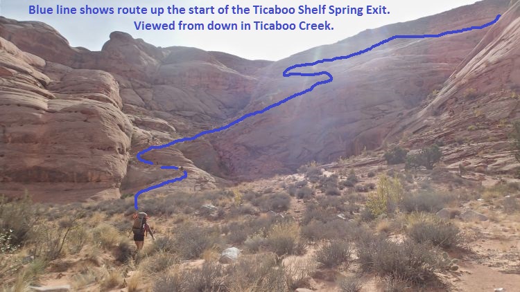
When you get to the large bowl like area on the RDC (southwest) side of Ticaboo Creek, follow up the old cairned cattle trail as shown.
Walk southwest about 300
feet through the flat
area in the bowl like
area over to the bottom
of the cairned cattle
trail (wTicShSpgEx01).
Follow the cairned route
about 400 feet to where
it crosses of the
drainage (wTicShSpgEx02)
then begins to travel
mostly southwest up a
series of about 10
switchbacks up toward
Ticaboo Shelf Spring.
Portions of the
switchbacks up to the
mesa top cross over some
sections of slickrock
making it difficult to
see where the trail
goes. Each of
these spots are short
and just a little
walking around will
allow you to see where
the trail continues.
A little over 0.2 miles
up the switch backs is
the top most switchback
on the cairned route
(wTicShSpgEx03).
From the last switchback
walk west about 1500
feet back to where the
vehicle is parked (pkTicShSpg).
Downloadable GPX files
available at
BG-Gear Store
(easier than manual entry and a great way to support
Bluugnome).
Waypoint naming convention and map symbol information can be found on the Glossary page.
Elevations are approximate.
BEFORE
manually entering coordinates set your system to WGS84 datum and Lat/Lon hddd.ddddd° coordinate format.
Inconsistent datum's and coordinate formats will result in location errors.
Click to show / expand the list of waypoints below........
| Trough Canyon (1) - Drive in to Trailhead |
- extTicaboo1
Lat/Lon (WGS84): N 37.69720
W -110.67138
Elev: 4,520 Feet
Exit off of highway 276 to get to the Ticaboo Mesa area. Turn east and leave the highway on a dirt road. Near Mile post 25.
- TicabooDP-01
Lat/Lon (WGS84): N 37.68607
W -110.65188
Elev: NaN Feet
Continue straight for the main area of Ticaboo Mesa. Or Turn right (south) here for an alternate route over toward the Smith Fork Canyons.
- TicabooDP-02
Lat/Lon (WGS84): N 37.67981
W -110.62886
Elev: NaN Feet
Road junction with faint road running to the south. Continue straight (east).
Road to the south is about 1.25 miles long and goes down toward Cane Spring Well.
- TicabooDP-03
Lat/Lon (WGS84): N 37.68038
W -110.62628
Elev: 4,565 Feet
Exit to a spot to camp if the roads ahead are too rough.
- TicabooDP-04
Lat/Lon (WGS84): N 37.67963
W -110.60429
Elev: NaN Feet
Junction for a road going south. Continue straiaght (north east) to continue toward Ticaboo Measa. This road junction is near Wild Horse Springs.
- TicabooDP-05
Lat/Lon (WGS84): N 37.68389
W -110.60153
Elev: NaN Feet
Junction for a side road on the left going north. Continue north east toward Ticaboo Mesa.
The road going north is BLM Road 13440 aobut 0.4 miles long and goes over toward Colt Spring.
- TicabooDP-06
Lat/Lon (WGS84): N 37.68667
W -110.59547
Elev: NaN Feet
Junction for a side road going north.
The Road north is BLM Road 13540 and goes out toward Upper South Fork Ticaboo.
- TicabooDP-07
Lat/Lon (WGS84): N 37.69529
W -110.58385
Elev: NaN Feet
Turn off for a side road on the right. Turn right onto the side road and drive southwest.
- extBLM-13460
Lat/Lon (WGS84): N 37.69800
W -110.57872
Elev: NaN Feet
Turn off to BLM road 13460 toward Shelf Spring
- pkTicShSpg
Lat/Lon (WGS84): N 37.70146
W -110.58039
Elev: 4,820 Feet
Wide parking spot near the end of BLM Road 13460 near a tank and trough by Ticaboo Shelf Spring. This spot is large enough for many cars.
|
| Trough Canyon (2) - Approach and Canyon |
- pkTicShSpg
Lat/Lon (WGS84): N 37.70146
W -110.58039
Elev: 4,820 Feet
Wide parking spot near the end of BLM Road 13460 near a tank and trough by Ticaboo Shelf Spring. This spot is large enough for many cars.
- yTroughTP
Lat/Lon (WGS84): N 37.70245
W -110.58089
Elev: 4,700 Feet
Top of Trough Canyon. This is where the Trough Canyon drainage drops down onto slickrock.
- dTroughR1
Lat/Lon (WGS84): N 37.70290
W -110.58069
Elev: NaN Feet
Rap 1 - Trough Canyon. Anchored from a large rock at the top of the drop and drops about
- wTroughRP-01
Lat/Lon (WGS84): N 37.70324
W -110.58087
Elev: NaN Feet
Downclimb of about 15 to 20 feet. Very wide stretch to get down this downclimb. A partner assist will make this drop a lot easier.
- wTroughRP-02
Lat/Lon (WGS84): N 37.70379
W -110.58068
Elev: NaN Feet
Start of a shallow V-slot area cutting through more cross joints.
- wTroughRP-03
Lat/Lon (WGS84): N 37.70422
W -110.58007
Elev: NaN Feet
Easy downclimb of 10 to 12 feet in a V-slot.
Over the next 250 feet are 3 more downclimbs of 10 to 12 feet each. These next three downclimbs are mostly vertical and are stem style downclimbs.
- wTroughRP-04
Lat/Lon (WGS84): N 37.70486
W -110.57969
Elev: NaN Feet
Drop of about 25 feet that is easily bypassed around on the RDC side.
- dTroughR2
Lat/Lon (WGS84): N 37.70492
W -110.57978
Elev: NaN Feet
Rap 2 - Trough Canyon. Anchored from a large rock in a small pothole and drops about 210 feet passing first over a small pothole then down a mostly vertical wall. Webbing can be tied to the large rock or use a retrievable anchor like the Smooth Operator. If Going Smooth from the large rock anchor it is VERY IMPORTANT to tie the stone knot twist free to avoid getting the rope stuck.
Optional Anchor for rap 2
Another option is to downclimb about 5 feet past the large rock anchor down to the next lower pothole that is only shin deep where you will find a crack on the canyon floor that can be used with a knot chalk anchor. This option would shorten the rappel to right at about 200 feet but would require leaving webbing for the knot chalk anchor.
Optional Technique to use a 200 foot rope
The final rappel can be done using a 50 foot rope, a 200 foot rope, a pull line of more than 210 feet and a retrievable anchor like the Smooth Operator or a Fiddlestick. Rig the large rock with the 50 foot rope using the Smooth Operator. Rappel down past the small pothole below and tie the 200 foot rope to 50 foot rope. Each person can rap on the 50 foot rope to the small pothole then pass the knot in the ropes while standing safely in the pothole then continue the rappel on the 200 foot rope. Using the Smooth Operator the knot in the ropes does not need to pass through a rap ring and simply fall down the drop when released.
- yTroughBt
Lat/Lon (WGS84): N 37.70546
W -110.57974
Elev: 4,290 Feet
Bottom of Trough Canyon where it meets the South Fork of Ticaboo Creek. Looking back up canyon it looks like Trough Canyon is nothing more than a pour off from the slickrock above.
|
| Trough Canyon (3) - Exit |
- yTroughBt
Lat/Lon (WGS84): N 37.70546
W -110.57974
Elev: 4,290 Feet
Bottom of Trough Canyon where it meets the South Fork of Ticaboo Creek. Looking back up canyon it looks like Trough Canyon is nothing more than a pour off from the slickrock above.
- jTicShSpgEx
Lat/Lon (WGS84): N 37.70453
W -110.57676
Elev: 4,280 Feet
Junction where you leave Ticaboo Creek and start up the Ticaboo Shelf Spring Exit route. THis route is mostly cairned and is an old cattle trail.
- wTicShSpgEx01
Lat/Lon (WGS84): N 37.70380
W -110.57650
Elev: NaN Feet
Bottom of the cairned cattle trail up to Ticaboo Shelf Spring.
- wTicShSpgEx02
Lat/Lon (WGS84): N 37.70295
W -110.57630
Elev: NaN Feet
Cairned trail crosses the draiange here to turn and travel mostly southwest up a series of about 10 switchbacks. Portions of the switchbacks up to the mesa top cross over some sections of slickrock making it difficult to see where the trail goes. Each of these spots are short and just a little walking around will allow you to see where the trail continues.
- wTicShSpgEx03
Lat/Lon (WGS84): N 37.70200
W -110.57783
Elev: NaN Feet
Top most switchback on the carined cattle trail.
- wTicShSpngTnk
Lat/Lon (WGS84): N 37.70234
W -110.58009
Elev: NaN Feet
Tank and water trough at Ticaboo Shelf Spring.
- pkTicShSpg
Lat/Lon (WGS84): N 37.70146
W -110.58039
Elev: 4,820 Feet
Wide parking spot near the end of BLM Road 13460 near a tank and trough by Ticaboo Shelf Spring. This spot is large enough for many cars.
|