Canyoneering Route Description
Sleepytime Trio - 4A III (II)
Rude Awakening, Siesta and Power Nap
Canyons
and side trip to Pipe Dream Canyon
Ticaboo Mesa, Utah
2015-10-10, 6 people, 1 Day (Travel time in route 8.1 hours)

Time Required (entire route) - 6 to 7 hours
Time Required (Rude Awakening only) - 4 to 5
hours
Distance (entire route) - 7.3 miles Total, 0.6 miles Technical
Distance (Rude Awakening only) - 5.2 miles
Total, 0.2 miles Technical
Rappels - 3 Rappels, Longest Rappel 190 feet.
Elevation Range - 5680 - 4280 Feet
Shuttle Required - No Vehicle - High Clearance, 4WD if bad road conditions
Permit Required - No
Rappelling and anchor gear, Ropes and or pull cords for rappels up
to 190 feet and 70 feet of 1 inch webbing for sling placement. A
Sandtrap is suggested although it may not be needed (see general
comments)
Sleepytime Trio is a collection of small slots on the east side of Upper
South Fork Ticaboo Creek that can be seen from Ticaboo Mesa. A few of us had
been looking at three slots with curiosity while out and about and finally
put a trip together to go look them over. We ended up naming these slots
collectively the Sleepytime Trio since there is very little substance to
them and could be worthy of some nap time. In fact some of the crew took a
nap while a few of us went to look over a fourth slot that we hoped would
offer a little play but did not pan out. Originally we aimed to check out 3
slots which is where the Trio part of the name came from. We ended up
looking at a fourth slot that day so the Sleepytime trio kind of includes 4
tiny drainages.
The Sleepytime Trio consists of Power Nap, Siesta and Rude Awakening. The
fourth slot just east of these was named Pipe Dream since our hopes for
finding fun in that slot turned out to be a pipe dream.
Power Nap and Siesta both require no ropes and can be easily escaped
before going over a huge vertical drop into a side fork of South Fork
Ticaboo Creek. Pipe Dream also requires no rope and is just a wide wash with
a 150 foot slot at the lower end that leads to a big drop into the same side
fork as Power Nap and Siesta. Rude Awakening is the only slot in the
collection that requires rope and drops down into the main South Fork
Ticaboo Creek drainage.
While the lower portion of Rude Awakening does offers some good technical
canyon fun it is VERY short and should not be considered a major
destination. The Sleepytime Trio is a good route if you want to see a less
traveled area and want more of a hiking / scrambling route with a short
technical canyon ending. This route description is laid out to offer a route
through Power Nap, wander through Pipe Dream, go through Siesta then over to
descend Rude Awakening down to South Fork Ticaboo Creek. Rude Awakening is
done last as it offers the technical fun and drops down into South Fork
Ticaboo Creek where the route then uses an old cattle trail to exit back up
to Ticaboo Shelf Spring.
The last 400 feet of Rude Awakening drops steeply down a deep narrow slot
and does require advanced anchor building skills with good technical
judgment. This final portion of Rude Awakening is the only
portion of the route that requires rope and technical skills and gives the
route the technical difficulty rating of 4. For rap 1 of Rude Awakening we
used a small shrub for an anchor which may not support subsequent rappels.
Alternate options would be a sandtrap or use chokestones set back abut 45
feet from the top of the drop. If the chokestones are used, you will need 50
feet of webbing to extend the anchor or a longer rope.
Note - short fun day:
If you want a short day out
with a short but fun technical portion, consider doing Rude Awakening only
and skipping the the non-technical canyons on the route.
To get to the Trailhead
Note:
There is a maze of roads on Ticaboo Mesa making it a good idea
to study the map ahead of time and keep a close eye on the map
as you drive.
From Hanksville, UT., drive south on highway 95 for 26 miles to
the junction of highways 95 and 276.
From the junction, drive south on HWY-276 for 25.6 miles then
turn left (east) onto BLM dirt-road 13400 between mile markers
25 and 26 (extTicaboo1).
About 1.5 miles from the highway is a junction (TicabooDP-01)
of BLM roads, 13400 continues east and 13410 branches off to the
south. Continue east on BLM road 13400. Note: If you were headed
to the Smith Fork area you would turn south onto BLM road 13410.
About 2 miles farther is another junction
(TicabooDP-02) of BLM roads, 13400 continues east and 13420
branches off to the south. Continue east on BLM road 13400.
Note: BLM road 13420 to the south goes out to Cane Spring Well
about 1.25 miles south.
About 0.2 miles farther is short side road (TicabooDP-03) on the
left (north) that goes to a camp area.
Stay right to
continue on BLM road 13400. Beyond this point the roads
will have intermittent rough sections.
About 0.37
miles past here is a fork in the road where the two roads rejoin
a short distance later. The low road is typically the
smoothest.
About 1.7 miles farther is another junction (TicabooDP-04) of
BLM roads (13400 continues north-ish and 13430 branches off to
the south).
Continue north on BLM road 13400.
Note: If you were going to the roads between Warm Springs Creek
and Sevenmile Creek, you would turn south onto BLM road 13430.
About 0.3 miles farther is another junction (TicabooDP-05) of
BLM roads (13400 continues northeast and 13440 branches off to
the north).
Continue straight northeast on BLM road 13400.
Note: BLM road 13440 to the south goes out to Colt Spring Well
about 0.4 miles north.
About 0.5 miles farther is a junction (TicabooDP-06) of BLM
roads (13400 continues northeast and 13450 branches off to the
north).
Continue straight northeast on BLM road 13400.
About 0.9 miles farther is a junction (TicabooDP-07) of BLM
roads (13400 continues northeast and 13430 branches off to the
south).
Continue northeast on BLM road 13400.
Note: If you
were going farther out onto Ticaboo Mesa, you would turn south
onto BLM road 13430.
About 0.3 miles farther is junction (extBLM-13460) of BLM roads
(13400 continues northeast and 13460 branches off to the north).
To Go to the parking for Trough, SF Ticaboo or the Sleepy Time
Trio Canyons, turn north onto BLM road 13460 toward Shelf
Spring.
To leave the Exit Vehicle / Escape Pod
No exit vehicle is needed. This is done as a loop route.
GPS coordinate information listed at the bottom. For information about waypoint naming and map symbols, refer to the
Glossary page.

Click the links for maps of the route.
Map of the drive into the route.
Map of the entire route.
Map of the canyons.
Map of the exit.
The Approach:
From the parking spot
(pkTicShSpg) look
northwest to a cone
shaped hill about 0.37
miles away. Walk west
over a couple small
drainages then up a
slope to get to the next
higher shelf to the left
of the hill.
When you get to the next
higher shelf
(SF-Tic-RP01) you will
be greeted with wide
open desert. Veer
right to walk north west
towards Mount Ellsworth
roughly following the
rim of the hill you just
came up.
About
0.55 miles farther
the route meets a road
(pkSF-TicOpt). Continue walking
northwest along the road
toward Mount Ellsworth.
The road fades away
about 250 feet farther
where you will route
find your way through
open desert.
Note:
Optionally you could
drive to here and start
the route setting a
shuttle / exit vehicle
at Ticaboo Shelf Spring.
Doing the shuttle saves
only mile of walking and
would likely save very
little if any time.
About 0.24 miles farther
is the bottom of a slope
(SF-Tic-RP02) to go up
to the northwest to get
up onto a very wide dirt
ridge running north.
This dirt slope is steep
with lots of loose rock
and a bit of work to go
up gaining about 200
vertical feet over 600
hundred horizontal feet.
After getting to the top
of the hill, veer right
to walk north along the
wide ridge.
About 0.37 miles along
the ridge the route
crosses over a minor
drainage (SF-Tic-RP03).
About 800 feet farther
north is a much larger
and deeper drainage that
is is easier to cross by
veering a little left
and travel up the side
to cross it where it is
more shallow.
As you cross around the
larger drainage
(SF-Tic-RP04) where it
is more shallow continue
north and note what
looks like a small dirt
hill on the horizon.
Route find your way
through the desert
aiming a little left of
the dirt hill.
About 0.2 miles after
crossing the large
drainage you will be on
the rim of Upper South
Fork Ticaboo
(SF-Tic-RP05).
Route find your way down
the sloped dirt and
slickrock into the
drainage for Upper South
Fork Ticaboo Creek.
Once down in the main
drainage for Upper South
Fork Ticaboo (ySF-Tic-Tp)
continue across the
Upper South Fork Ticaboo
drainage and continue
northeast up the other
side about 500 feet to
the top of a small short
drainage running down to
the southeast.
From the top end of a
small drainage
(SleepyTrioRp01) running
down to the southeast,
follow southeast about
300 feet to where the
drainage begins to widen
out then continue
southeast contouring
along the south side of
a hill. The hill will be
on your left and Upper
South fork Ticaboo will
be on your right.
After about 0.5 miles
you will be on the other
end of the hill at a
saddle (SleepyTrioRp02).
Continue south about 450
feet toward the base of
another large hill.
When you get to the base
of the next hill
(SleepyTrioRp03),
continue south by
contouring around the
right (west) side of
this hill for about 0.37
miles to the other end.
Note:
About half way along the
side of this hill is the
top of a steep drainage
(SleepyTrioRp04) running
down to the right (west)
down into South Fork
Ticaboo Creek very close
to the final rap of that
route.
On the other end of the
hill is a saddle
(SleepyTrioRp05) at the
southern end of a hill
that was contoured
around. Veer left and
route find your way
about 250 feet east down
to the top of Rude
Awakening.
When you get to the top
of Rude Awakening
(yRudeAwakenTp) which is
a shallow slot forming
and running down to the
southwest you have the
option to first go check
out the other three
slots in the area or
drop down Rude Awakening
only.
Note:
If you are
dropping down
Rude
Awakening only,
skip to
the section for Rude
Awakening Canyon.
If you want to follow
the whole route and see
the other slots continue
reading from here.
The Canyoneering / Technical Sections:
To go over to
Siesta Canyon walk
northeast about 800 feet
to the head of Siesta
Canyon, contouring
around a point on the
way.
At the top of Siesta
Canyon (ySiestaTp), is
where the shallow slot
begins to form below a
wide valley like area.
Cross over Siesta Canyon
and then route find
north about 400 feet up
to the head of Power Nap
Canyon (yPowerNapTp).
Drop into Power
Nap Canyon (yPowerNapTp)
and galumph a little
over 200 feet down
canyon to some boulder
debris to scramble over
(PowerNap01).
Continue galumphing down
canyon about 230 feet to
a stem style downclimb /
elevator of about 15
feet (PowerNap02) down
to a small pool that can
be galumphed over. Tall
people can stem down
over the whole thing.
About 200 feet farther
the canyon opens up to
wide spaces
(PowerNap03). Walk
about 650 feet down
canyon to the lower end
of the wide wash (yPowerNapBt)
where you can escape up
out of either side.
Beyond here the canyon
rolls off into a couple
potholes then to a big
drop down into a side
drainage. If you want to
look at the final 200
feet it is easy to walk
down along the LDC side
and look it over.
To go over to Pipe Dream
exit the LDC (east) side
and route find your way
east about 800 feet to
the rim at the lower end
of Pipe Dream
(PipeDream01).
From the rim of
Pipe Dream
(PipeDream01) scramble
down steep slickrock
down into the canyon.
You can also scramble
down into Pipe Dream
about 250 north of here
where it is a little
less steep.
Once down in the canyon
you can walk a short
distance down to the top
of the final slot of
Pipe Dream (yPipeDreamTp)
where a very sort slot
forms at the end of Pipe
Dream. Down canyon of
here is a slot about 150
feet long before getting
to a big drop into a
side drainage. The first
80 feet are easy to stem
/ galumph down to where
you can see most of the
remaining 70 feet of
slot. The potholes in
this section can hold
water.
Walking up Pipe Dream
Canyon offers no
technical fun. I
walked about 900 feet up
to where I had a view of
open wash all the way to
the head of the
drainage. After
looking around in Pipe
Dream Canyon exit up to
the rim where you
scrambled in, then go
back to the lower end of
Power Nap Canyon.
From the bottom of Power
Nap exit the RDC (west)
side then route find
your way a little over
1000 feet east to the
head of Siesta Canyon.
From the head of
Siesta Canyon (ySiestaTp)
walk / galumph south-ish
down canyon with a
couple pools to bridge
over or walk around.
About 200 feet down
Siesta is the start of
(Siesta01) a section
with small silo /
shallow potholes to
downclimb through or
bypass all of them along
the LDC (west) side.
About 225 feet farther
down Siesta is a little
bit of boulder debris
(Siesta02) to scramble
over / around.
About 80 feet down
canyon is a good spot to
exit (Siesta03) the
canyon on the LDC side
just before the final
last 170 feet of canyon.
The final 170 feet of
canyon is a series of 8
to 10 potholes that you
could play through. The
potholes have drops on
the down canyon side
ranging from 5 to 15
feet and none of the
potholes looked deep and
would yield easily to
partner assist escapes.
After the pothole
section is a side slot
on the LDC to scramble
up out of the canyon. We
bypassed the short
pothole section.
After playing through
the lower slots or
bypassing as we did exit
the LDC side and route
find your way along the
rim back to the top of
Siesta Canyon.
From the head of Siesta
Canyon (ySiestaTp) walk
west about 0.2 miles to
the head of Rude
Awakening (yRudeAwakenTp).
Drop down Rude
Awakening Canyon:
From the head of Rude
Awakening travel down
canyon to the southwest
with a mix of walking
and light galumphing or
walk along
the LDC side up out of
the shallow drainage.
A little over 150 feet
down Rude Awakening is a
more shallow side fork
joining (RudeAwaken01)
in from the LDC (east)
side. Continue down
canyon with light
galumphing.
About 225 feet farther
is a small section of
rock fall debris
(RudeAwaken02) just
after 3 downclimbs of 6
to 8 feet each. Continue
galumphing down canyon
for a little over 150
feet to a downclimb of
about 10 feet then rap
1.
Rap 1 (dRudeAwakenR1)
just after a downclimb
of about 10 feet is
anchored from a small
shrub about 10 feet back
and uses about 190 feet
of rope travel over 2
stages with a pothole to
cross at the bottom of
the first stage. At the
bottom of rap 1 the
canyon veers right and a
small side canyon comes
in from LDC.
Note:
The shrub anchor for rap
1 is small and
may not always be there
or solid enough to
rappel from. Alternate
options are using a sandtrap or
using chokestones about
50 feet back. Using the
chokestones will require
a long webbing extension
or longer ropes.
Rap 2 (dRudeAwakenR2) is
shortly after rap 1, is
anchored from one of
many large rocks, has an
awkward start over a
large boulder and drops
about 70 feet down a
mostly vertical wall.
After rap 2 stem,
galumph and scramble
over boulder debris down
a deep narrow slot
dropping quickly and
slowly becoming more
level.
Rap 3 (dRudeAwakenR3) is
about 250 feet down
canyon of rap 2, is
anchored from a large
rock down in a pothole
and drops about 140 feet
with the last two thirds
being free hanging.
After rap 3 walk wide
open wash about 430 feet
down to the end of the
canyon where it dumps
into South Fork Ticaboo
Creek (yRudeAwakenBt).
The Exit:
From the end of
the Rude Awakening Canyon (yRudeAwakenBt)
turn left and walk southeast
down South Fork Ticaboo
Creek.
About
900 feet down canyon will be
a large side drainage coming
in on the RDC (west) side.
About
0.27 miles farther down
canyon is another large side
drainage (yTicaMes50Bt)
coming in on the RDC (west)
side.
Note - Side Trip
If you have extra time
and want to wonder
around in a short serene
feeling slot
you can wonder into the
bottom of this deep looking
canyon / drainage. You can
wonder about 350 feet up
the canyon to the base
of a drop of 60 feet or
so high. There is
only one boulder to
scramble over on the way
up. The canyon has
a very secluded and
quiet feel with some
vegetation and lots of
shade.
About
0.35 miles farther down South Fork Ticaboo Creek is
a wide open bowl like area
on the RDC (southwest) side
of Ticaboo Creek
(jTicShSpgEx).
Note:
About 1000 feet before
getting to the wide open
bowl you will pass by the
bottom of Trough Canyon (yTroughBt)
on the RDC side.
However
Trough canyon may go
un-noticed as it is not a
major drainage and the exit
is a rappel down from a
ledge.
When
you get to the wide
open bowl like area on the
RDC (southwest) side
(jTicShSpgEx), walk southwest about 300
feet through the flat
area in the bowl like
area over to the bottom
of the cairned cattle
trail (wTicShSpgEx01)..
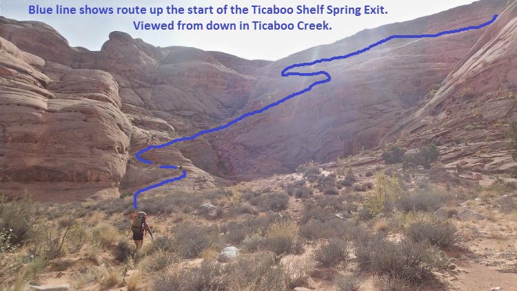
When you get to the large bowl like area on the RDC (southwest) side of Ticaboo Creek, follow up the old cairned cattle trail as shown.
Follow the cairned route
about 400 feet to where
it crosses of the
drainage (wTicShSpgEx02)
then begins to travel
mostly southwest up a
series of about 10
switchbacks up toward
Ticaboo Shelf Spring.
Portions of the
switchbacks up to the
mesa top cross over some
sections of slickrock
making it difficult to
see where the trail
goes. Each of
these spots are short
and just a little
walking around will
allow you to see where
the trail continues.
A little over 0.2 miles
up the switch backs is
the top most switchback
on the cairned route
(wTicShSpgEx03).
From the last switchback
walk west about 1500
feet back to where the
vehicle is parked (pkTicShSpg).
Downloadable GPX files
available at
BG-Gear Store
(easier than manual entry and a great way to support
Bluugnome).
Waypoint naming convention and map symbol information can be found on the Glossary page.
Elevations are approximate.
BEFORE
manually entering coordinates set your system to WGS84 datum and Lat/Lon hddd.ddddd° coordinate format.
Inconsistent datum's and coordinate formats will result in location errors.
Click to show / expand the list of waypoints below........
| Sleepytime Trio (1) - Drive to Trailhead |
- extTicaboo1
Lat/Lon (WGS84): N 37.69720
W -110.67138
Elev: 4,520 Feet
Exit off of highway 276 to get to the Ticaboo Mesa area. Turn east and leave the highway on a dirt road. Near Mile post 25.
- TicabooDP-01
Lat/Lon (WGS84): N 37.68607
W -110.65188
Elev: NaN Feet
Continue straight for the main area of Ticaboo Mesa. Or Turn right (south) here for an alternate route over toward the Smith Fork Canyons.
- TicabooDP-02
Lat/Lon (WGS84): N 37.67981
W -110.62886
Elev: NaN Feet
Road junction with faint road running to the south. Continue straight (east).
Road to the south is about 1.25 miles long and goes down toward Cane Spring Well.
- TicabooDP-03
Lat/Lon (WGS84): N 37.68038
W -110.62628
Elev: 4,565 Feet
Exit to a spot to camp if the roads ahead are too rough.
- TicabooDP-04
Lat/Lon (WGS84): N 37.67963
W -110.60429
Elev: NaN Feet
Junction for a road going south. Continue straiaght (north east) to continue toward Ticaboo Measa. This road junction is near Wild Horse Springs.
- TicabooDP-05
Lat/Lon (WGS84): N 37.68389
W -110.60153
Elev: NaN Feet
Junction for a side road on the left going north. Continue north east toward Ticaboo Mesa.
The road going north is BLM Road 13440 aobut 0.4 miles long and goes over toward Colt Spring.
- TicabooDP-06
Lat/Lon (WGS84): N 37.68667
W -110.59547
Elev: NaN Feet
Junction for a side road going north.
The Road north is BLM Road 13540 and goes out toward Upper South Fork Ticaboo.
- TicabooDP-07
Lat/Lon (WGS84): N 37.69529
W -110.58385
Elev: NaN Feet
Turn off for a side road on the right. Turn right onto the side road and drive southwest.
- extBLM-13460
Lat/Lon (WGS84): N 37.69800
W -110.57872
Elev: NaN Feet
Turn off to BLM road 13460 toward Shelf Spring
- pkTicShSpg
Lat/Lon (WGS84): N 37.70146
W -110.58039
Elev: 4,820 Feet
Wide parking spot near the end of BLM Road 13460 near a tank and trough by Ticaboo Shelf Spring. This spot is large enough for many cars.
To go to Trough Canyon, walk north down the dirt slope almost 500 feet to drop in.
To go to Upper South Fork Ticaboo Canyon or the Sleepytime Trio look northwest to a cone shaped hill about 0.37 miles away. Walk west over a couple small drainages then up a slope to get to the next higher shelf to the left of the hill.
|
| Sleepytime Trio (2) - Approach to Rude Awakening |
- pkTicShSpg
Lat/Lon (WGS84): N 37.70146
W -110.58039
Elev: 4,820 Feet
Wide parking spot near the end of BLM Road 13460 near a tank and trough by Ticaboo Shelf Spring. This spot is large enough for many cars.
To go to Trough Canyon, walk north down the dirt slope almost 500 feet to drop in.
To go to Upper South Fork Ticaboo Canyon or the Sleepytime Trio look northwest to a cone shaped hill about 0.37 miles away. Walk west over a couple small drainages then up a slope to get to the next higher shelf to the left of the hill.
- SF-Tic-RP01
Lat/Lon (WGS84): N 37.70051
W -110.58669
Elev: 5,035 Feet
Up on the next higher shelf after walking west from Ticaboo Shelf Spring. To continue to SF Ticaboo Canyon or Sleepytime Trio, veer right to walk north west towards Mount Ellsworth roughly following the rim of the hill you just came up.
- pkSF-TicOpt
Lat/Lon (WGS84): N 37.70658
W -110.59337
Elev: 5,125 Feet
When walking into South Fork Ticaboo, the route meets a road here. Continue walking northwest along the road toward Mount Ellsworth. The road fades away about 250 feet farther where you will route find your way through open desert.
Optionally you could drive to here and start the route setting a shuttle / exit vehicle at Ticaboo Shelf Spring. Doing the shuttle saves only mile of walking and would likely save very little if any time.
- SF-Tic-RP02
Lat/Lon (WGS84): N 37.70871
W -110.59676
Elev: 5,200 Feet
Bottom of a slope to go up to the northwest to get up onto a very wide dirt ridge running north. This dirt slope is steep with lots of loose rock and a bit of work to go up gaining about 200 vertical feet over 600 hundred horizontal feet. After getting to the top of the hill, veer right to walk north along the wide ridge.
- SF-Tic-RP03
Lat/Lon (WGS84): N 37.71358
W -110.59892
Elev: NaN Feet
Crossing over a minor drainage on the way over to South Fork Ticaboo. About 800 feet farther north is a much larger and deeper drainage that is is easier to cross by veering a little left and travel up the side to cross it where it is more shallow.
- SF-Tic-RP04
Lat/Lon (WGS84): N 37.71727
W -110.59868
Elev: NaN Feet
Crossing over a large drainage up higher where it is more shallow. As you continue north, note what looks like a small dirt hill on the horizon. Route find your way through the desert aiming a little left of the dirt hill.
- SF-Tic-RP05
Lat/Lon (WGS84): N 37.72025
W -110.59814
Elev: NaN Feet
From the rim here, route find your way down the sloped dirt and slickrock into the drainage for Upper South Fork Ticaboo Creek.
- ySF-Tic-Tp
Lat/Lon (WGS84): N 37.72167
W -110.59747
Elev: 5,530 Feet
Top of Upper South Fork Ticaboo. About 60 feet southeast down canyon is the first drop in the canyon.
To go over to the Sleepytime Trio, cross Upper SF Ticaboo and continue northeast up the other side about 500 feet to the top of a small short drainage running down to the southeast.
- SleepyTrioRp01
Lat/Lon (WGS84): N 37.72270
W -110.59661
Elev: 5,550 Feet
Top end of a small drainage running down to the southeast. Follow southeast about 300 feet to where the drainage begins to widen out then continue southeast contouring along the south side of a hill. The hill will be on your left and Upper South fork Ticaboo will be on your right.
- SleepyTrioRp02
Lat/Lon (WGS84): N 37.71858
W -110.58942
Elev: NaN Feet
Saddle the route crosses after contouring under a large hill. Continue south about 450 feet toward the base of another large hill.
- SleepyTrioRp03
Lat/Lon (WGS84): N 37.71744
W -110.58894
Elev: 5,210 Feet
Base of another large hill. Continue south by contouring around the right (west) side of this hill for about 0.37 miles to the other end.
- SleepyTrioRp04
Lat/Lon (WGS84): N 37.71540
W -110.58959
Elev: NaN Feet
Top of a steep drainage running down to the right (west) down into South Fork Ticaboo Creek very close to the final rap of that route.
- SleepyTrioRp05
Lat/Lon (WGS84): N 37.71275
W -110.58841
Elev: NaN Feet
Saddle at the southern end of a hill that was contoured around. Veer left and route find your way about 250 feet east down to the top of Rude Awakening.
- yRudeAwakenTp
Lat/Lon (WGS84): N 37.71307
W -110.58761
Elev: 4,950 Feet
Top of Rude Awakening Canyon.
To go over to Siesta Canyon walk northeast about 800 feet to the head of Siesta Canyon, contouring around a point on the way.
To drop down Rude Awakening travel down canyon to the southwest with a mix of walking and light galumphing. Also easy to walk along the LDC side up out of the shallow drainage.
|
| Sleepytime Trio (3) - Route thru Power Nap, Pipe Dream and Siesta |
- yRudeAwakenTp
Lat/Lon (WGS84): N 37.71307
W -110.58761
Elev: 4,950 Feet
Top of Rude Awakening Canyon.
To go over to Siesta Canyon walk northeast about 800 feet to the head of Siesta Canyon, contouring around a point on the way.
To drop down Rude Awakening travel down canyon to the southwest with a mix of walking and light galumphing. Also easy to walk along the LDC side up out of the shallow drainage.
- ySiestaTp
Lat/Lon (WGS84): N 37.71379
W -110.58535
Elev: 4,925 Feet
Top of Siesta Canyon. This is where the shallow slot begins to form below a wide valley like area.
To go to the top of Power Nap Canyon hop across the shallow slot here then route find north about 400 feet up to the head of Power Nap Canyon.
To drop down Siesta Canyon walk / galumph south-ish down canyon with a couple pools to bridge over or walk around.
- yPowerNapTp
Lat/Lon (WGS84): N 37.71480
W -110.58572
Elev: 4,965 Feet
Top of Power Nap Canyon. Galumph a little over 200 feet down canyon to some boulder debris to scramble over.
- PowerNap01
Lat/Lon (WGS84): N 37.71507
W -110.58503
Elev: NaN Feet
Some boulder debris to scramble over and continue galumphing down canyon.
- PowerNap02
Lat/Lon (WGS84): N 37.71521
W -110.58425
Elev: NaN Feet
Stem style downclimb / elevator of about 15 feet down to a small pool that can be galumphed over. Tall people can stem down over the whole thing.
- PowerNap03
Lat/Lon (WGS84): N 37.71532
W -110.58347
Elev: NaN Feet
Canyon opens up to wide spaces.
- yPowerNapBt
Lat/Lon (WGS84): N 37.71428
W -110.58198
Elev: 4,697 Feet
Bottom of Power Nap Canyon. This is at the lower end of a wide open area where you can escape up out of either side. Beyond here the canyon rolls off into a couple potholes then to a big drop down into a side drainage. If you want to look at the final 200 feet it is easy to walk down along the LDC side and look it over.
To go over to Pipe Dream exit the LDC (east) side and route find your way east about 800 feet to the rim at the lower end of Pipe Dream.
To exit and go over to Siesta Canyon exit the RDC (west) side then route find your way a little over 1000 feet east to the head of Siesta Canyon.
- PipeDream01
Lat/Lon (WGS84): N 37.71499
W -110.58010
Elev: NaN Feet
On the rim of Pipe Dream where you can scramble down steep slickrock down into the canyon. You can also scramble down into Pipe Dream about 250 north of here where it is a little less steep.
- yPipeDreamTp
Lat/Lon (WGS84): N 37.71480
W -110.57988
Elev: 4,650 Feet
This is where a very sort slot forms at the end of Pipe Dream. Down canyon of here is a slot about 150 feet long before getting to a big drop into a side drainage. The first 80 feet are easy to stem / galumph down to where you can see most of the remaining 70 feet of slot. The potholes in this section can hold water. Up canyon of here is open wash to hike in if you like.
- PipeDream02
Lat/Lon (WGS84): N 37.71694
W -110.58091
Elev: 4,693 Feet
Took a run up canyon to here and could see open wash all the way to the head of the dranange.
- yPowerNapBt
Lat/Lon (WGS84): N 37.71428
W -110.58198
Elev: 4,697 Feet
Bottom of Power Nap Canyon. This is at the lower end of a wide open area where you can escape up out of either side. Beyond here the canyon rolls off into a couple potholes then to a big drop down into a side drainage. If you want to look at the final 200 feet it is easy to walk down along the LDC side and look it over.
To go over to Pipe Dream exit the LDC (east) side and route find your way east about 800 feet to the rim at the lower end of Pipe Dream.
To exit and go over to Siesta Canyon exit the RDC (west) side then route find your way a little over 1000 feet east to the head of Siesta Canyon.
- ySiestaTp
Lat/Lon (WGS84): N 37.71379
W -110.58535
Elev: 4,925 Feet
Top of Siesta Canyon. This is where the shallow slot begins to form below a wide valley like area.
To go to the top of Power Nap Canyon hop across the shallow slot here then route find north about 400 feet up to the head of Power Nap Canyon.
To drop down Siesta Canyon walk / galumph south-ish down canyon with a couple pools to bridge over or walk around.
- Siesta01
Lat/Lon (WGS84): N 37.71331
W -110.58498
Elev: NaN Feet
Start of a section with small silo / shallow potholes to downclimb through or bypass all of them along the LDC (west) side.
- Siesta02
Lat/Lon (WGS84): N 37.71290
W -110.58443
Elev: NaN Feet
A little bit of boulder debris to scramble over / around.
- Siesta03
Lat/Lon (WGS84): N 37.71275
W -110.58424
Elev: NaN Feet
As with other spots you can easily escape on the LDC side and walk along the canyon. The final 170 feet of canyon below here is a series of 8 to 10 potholes that you could play through. The potholes have drops on the down canyon side ranging from 5 to 15 feet and none of the potholes looked deep and would yield easily to partner assist escapes. After the pothole section is a side slot on the LDC to scramble up out of the canyon. We bypassed the short pothole section.
- ySiestaBt
Lat/Lon (WGS84): N 37.71249
W -110.58361
Elev: 4,680 Feet
Bottom of Siesta Canyon where a side slot allows a scramble down into or up out of the LDC side of the canyon. Just after this side slot is a big drop down into a side drainage. From here exit the canyon out the crack on the LDC side then route find your way northwest along the rim ack to the head.
Looking at Google Earth it appears you would be able to get up to a saddle if you dropped down into the side drainage but you actually can not get up to the saddle as it is a vertical wall at the head.
- yRudeAwakenTp
Lat/Lon (WGS84): N 37.71307
W -110.58761
Elev: 4,950 Feet
Top of Rude Awakening Canyon.
To go over to Siesta Canyon walk northeast about 800 feet to the head of Siesta Canyon, contouring around a point on the way.
To drop down Rude Awakening travel down canyon to the southwest with a mix of walking and light galumphing. Also easy to walk along the LDC side up out of the shallow drainage.
|
| Sleepytime Trio (4) - Rude Awaknig and Exit |
- yRudeAwakenTp
Lat/Lon (WGS84): N 37.71307
W -110.58761
Elev: 4,950 Feet
Top of Rude Awakening Canyon.
To go over to Siesta Canyon walk northeast about 800 feet to the head of Siesta Canyon, contouring around a point on the way.
To drop down Rude Awakening travel down canyon to the southwest with a mix of walking and light galumphing. Also easy to walk along the LDC side up out of the shallow drainage.
- RudeAwaken01
Lat/Lon (WGS84): N 37.71270
W -110.58726
Elev: NaN Feet
A more shallow side fork joins in from the LDC (east) side. Continue down canyon with light galumphing.
- RudeAwaken02
Lat/Lon (WGS84): N 37.71219
W -110.58688
Elev: NaN Feet
Small section of rock fall debris just after 3 downclimbs of 6 to 8 feet each. Continue galumphing down canyon for a little over 150 feet to a downclimb of about 10 feet then rap 1.
- dRudeAwakenR1
Lat/Lon (WGS84): N 37.71178
W -110.58662
Elev: 4,790 Feet
Rap 1 - Rude Awakening just after a downclimb of about 10 feet. Anchored from a small shrub about 10 feet back and uses about 190 feet of rope travel over 2 stages with a pothole to cross at the bottom of the first stage. At the bottom of rap 1 the canyon veers right and a small side canyon comes in from LDC.
Note:
The shrub is small and may not always be there or solid enough to rappel from. Alternate options are using a sandtrap or using chokestones about 50 feet back. Using the chokestones will require a long webbing extension or longer ropes.
- dRudeAwakenR2
Lat/Lon (WGS84): N 37.71172
W -110.58637
Elev: NaN Feet
Rap 2 - Rude Awakening. Anchored from one of many large rocks, has an awkward start over a large boulder and drops about 70 feet down a mostly vertical wall.
After rap 2 stem, galumph and scramble over boulder debris down a deep narrow slot dropping quickly and slowly becoming more level.
- dRudeAwakenR3
Lat/Lon (WGS84): N 37.71095
W -110.58626
Elev: NaN Feet
Rap 3 - Rude Awakening. Anchored from a large rock down in a pothole and drops about 140 feet with the last two thirds being free hanging.
After rap 3 walk wide open wash about 430 feet down to the end of the canyon where it dumps into South Fork Ticaboo Creek.
- yRudeAwakenBt
Lat/Lon (WGS84): N 37.70973
W -110.58690
Elev: 4,355 Feet
Bottom of Rude Awakening where it meets South Fork Ticaboo Creek.
To exit turn left and walk southeast down South Fork Ticaboo Creek about 0.8 miles to a wide open bowl like area on the RDC (west) side. You will pass two large drainages on the RDC side on the way to the bowl.
- yTicaMes50Bt
Lat/Lon (WGS84): N 37.70580
W -110.58190
Elev: NaN Feet
Bottom end of a slot dropping down to the southern most fork of the South Fork of Ticaboo Creek. No technical value but hiking in from the bottoom is a quiet serene feeling and worth the trip for some scenic value. You can hike up about 350 up into the canyon with only one boulder to scramble over. The journey ends when you get to the base of a drop of about 60 feet or so high.
- yTroughBt
Lat/Lon (WGS84): N 37.70546
W -110.57974
Elev: 4,290 Feet
Bottom of Trough Canyon where it meets the South Fork of Ticaboo Creek. Looking back up canyon it looks like Trough Canyon is nothing more than a pour off from the slickrock above.
- jTicShSpgEx
Lat/Lon (WGS84): N 37.70453
W -110.57676
Elev: 4,280 Feet
Junction where you leave Ticaboo Creek and start up the Ticaboo Shelf Spring Exit route. THis route is mostly cairned and is an old cattle trail.
- wTicShSpgEx01
Lat/Lon (WGS84): N 37.70380
W -110.57650
Elev: NaN Feet
Bottom of the cairned cattle trail up to Ticaboo Shelf Spring.
- wTicShSpgEx02
Lat/Lon (WGS84): N 37.70295
W -110.57630
Elev: NaN Feet
Cairned trail crosses the draiange here to turn and travel mostly southwest up a series of about 10 switchbacks. Portions of the switchbacks up to the mesa top cross over some sections of slickrock making it difficult to see where the trail goes. Each of these spots are short and just a little walking around will allow you to see where the trail continues.
- wTicShSpgEx03
Lat/Lon (WGS84): N 37.70200
W -110.57783
Elev: NaN Feet
Top most switchback on the carined cattle trail.
- wTicShSpngTnk
Lat/Lon (WGS84): N 37.70234
W -110.58009
Elev: NaN Feet
Tank and water trough at Ticaboo Shelf Spring.
- pkTicShSpg
Lat/Lon (WGS84): N 37.70146
W -110.58039
Elev: 4,820 Feet
Wide parking spot near the end of BLM Road 13460 near a tank and trough by Ticaboo Shelf Spring. This spot is large enough for many cars.
To go to Trough Canyon, walk north down the dirt slope almost 500 feet to drop in.
To go to Upper South Fork Ticaboo Canyon or the Sleepytime Trio look northwest to a cone shaped hill about 0.37 miles away. Walk west over a couple small drainages then up a slope to get to the next higher shelf to the left of the hill.
|