Canyoneering Route Description
Good Day Jim Canyon - 3B III
Left (west) and Right (east) Forks
Ticaboo Mesa, Utah.
03-03-13, 6 people, 1 Day (Travel time in route 6 hours)
 Left (west) Fork
11-10-14, 4 people, 1 Day (Travel time in route 6.25 hours)
Right (east) Fork
Time Required - 5 - 8
Distance Left (west) Fork - 5.6 miles Total, 1.7 miles Technical
Distance Right (east) Fork - 5.8 miles Total, 1.6 miles Technical
Rappels - 5 Rappels, Longest Rappel 90 feet.
Actual longest drop is 35 feet but rap 2 requires 90 feet of
rope travel.
Elevation Range - 4860 - 3770 Feet
Shuttle Required - No Miles Vehicle - High Clearance,
4WD if roads are bad
Permit Required - No
Rappelling and anchor gear, Ropes and or pull cords for rappels up
to 90 feet and 50 feet of 1 inch webbing for sling placement.
The longest actual drop in the canyon is about 35 feet.
However a rope of about 90 feet will be used for rap 2 as you pass three
large potholes which may or may not need rope depending on conditions.
Wet
suits will generally be needed since Good Day Jim can hold a lot of
water. Also have a couple potshots and other pothole escape
stuff on hand in case the pothole conditions change and they are
needed.
There are two exit options for the Good Day Jim and
Hard Day Harvey routes. The West exit option is described here.
For information on the East exit see the route description for Hard Day
Harvey.
Described here are options for the Left (west) Fork and
for the Right (east) Fork of Good Day Jim. Each fork is close to 0.5
miles long and each fork has its own character. After the two forks
merge they follow the same route down the main portion of the canyon.
The Left (west) Fork
Up canyon of the confluence of the two forks, the Left Fork has a few minor downclimbs, a
short rap down then the possible keeper pothole. Shortly after the
keeper pothole is the confluence of the Right and Left Forks.
The Right (east) Fork
Up canyon of the confluence of the two forks, the Right Fork has a series
of 3 fun elevator like downclimbs of 15 to 25 feet each and spicy downclimb
/ rappel at the head of the canyon. The downclimbs are fun and in very
deep feeling slot making this an attractive option even though you don't get
to play in the keeper pothole of the Left Fork.
Wet suits recommended since the canyon can hold
significant amounts of water and a few potholes may require some time to get
past. Other than the potholes Good Day Jim can have a lot of places
with waist to chest deep water to wade through.
The longest actual drop in the canyon is about 35 feet.
However a rope of about 90 feet will be used for rap 2 as you pass three
large potholes which may or may not need rope depending on conditions.
Warning:
Good Day Jim has multiple potholes to cross. Most
of the potholes have sand filled bottoms. The depths and seriousness
of the potholes can change as sand is washed in or scoured out over time.
Some potholes can be keepers in the right conditions. One of the
potholes had been a 15 foot deep keeper in the past, it was only 5
feet deep during our visit in March 2013 and was again very deep on our
visit in November 2014. The description listed here
covers the conditions we found on our visit in March 2013 where we had dry
conditions. Always go prepared with pothole escape
stuff.
To get to the Trailhead
Note:
There is a maze of roads on Ticaboo Mesa making it a good idea
to study the map ahead of time and keep a close eye on the map
as you drive.
From Hanksville, UT., drive south on highway 95 for 26 miles to
the junction of highways 95 and 276.
From the junction, drive south on HWY-276 for 25.6 miles then
turn left (east) onto BLM dirt-road 13400 between mile markers
25 and 26 (extTicaboo1).
About 1.5 miles from the highway is a junction (TicabooDP-01)
of BLM roads, 13400 continues east and 13410 branches off to the
south. Continue east on BLM road 13400. Note: If you were headed
to the Smith Fork area you would turn south onto BLM road 13410.
About 2 miles farther is another junction
(TicabooDP-02) of BLM roads, 13400 continues east and 13420
branches off to the south. Continue east on BLM road 13400.
Note: BLM road 13420 to the south goes out to Cane Spring Well
about 1.25 miles south.
About 0.2 miles farther is short side road (TicabooDP-03) on the
left (north) that goes to a camp area.
Stay right to
continue on BLM road 13400. Beyond this point the roads
will have intermittent rough sections.
About 0.37
miles past here is a fork in the road where the two roads rejoin
a short distance later. The low road is typically the
smoothest.
About 1.7 miles farther is another junction (TicabooDP-04) of
BLM roads (13400 continues north-ish and 13430 branches off to
the south).
Continue north on BLM road 13400.
Note: If you were going to the roads between Warm Springs Creek
and Sevenmile Creek, you would turn south onto BLM road 13430.
About 0.3 miles farther is another junction (TicabooDP-05) of
BLM roads (13400 continues northeast and 13440 branches off to
the north).
Continue straight northeast on BLM road 13400.
Note: BLM road 13440 to the south goes out to Colt Spring Well
about 0.4 miles north.
About 0.5 miles farther is a junction (TicabooDP-06) of BLM
roads (13400 continues northeast and 13450 branches off to the
north).
Continue straight northeast on BLM road 13400.
About 0.9 miles farther is a junction (TicabooDP-07) of BLM
roads (13400 continues northeast and 13430 branches off to the
south).
Turn south onto BLM road 13430.
Note: If you were
going to Tough, SF Ticaboo or Sleepytime Trio Canyons you would
continue northeast on BLM road 13400.
About 700 feet farther is a fork in the road (extWarmSpring).
At this fork stay left to continue toward the East Branch of
Seven Mile Creek.
About 0.4 miles farther is another fork in the road
(ext7MileCkEB). Veer right (more south) to continue toward
the East Branch of 7 Mile Creek.
About 1.0 mile farther is a junction (7MileCkEBDP-01) where a
side road joins in from the left. Continue straight
(south) past the side road.
About 0.5 miles farther is a jog in the road (7MileCkEBDP-02)
near an old stock pond. Turning left leads to a berm with
a survey marker by a stock pond. Veer right to continue south.
As you drive south from the stock pond, the road crosses over
some shallow washes. Park off to the side of the road by
the wash that is 0.75 miles past the stock pond (pkGoodDayJim).
There is no obvious spot to park, just park off to the side of
the road to allow traffic to pass while you are gone. Over
time the parking spot has become more used and easier to spot.
To leave the Exit Vehicle / Escape Pod
No exit vehicle is needed. This is done as a loop route.
GPS coordinate information listed at the bottom. For information about waypoint naming and map symbols, refer to the
Glossary page.

Click the links for maps of the route.
Map of the drive into the route.
Map of the entire route.
Zoomed in route map 1.
Zoomed in route map 2.
The Approach:
From
the parking spot (pkGoodDayJim)
follow the wash
southwest.
About
0.3 miles from the rod
is a dry fall
(wGoodDayRP-01) of about
10 feet that is easily
bypassed.
About 700 feet farther
From the parking spot (pkGoodDayJim)
follow the wash
southwest.
About
0.3 miles from the rod
is a dry fall
(wGoodDayRP-01) of about
10 feet that is easily
bypassed.
About 700 feet farther
is another dry fall
(wGoodDayRP-02) of about
8 feet that is easily
scrambled down.
About 900 feet farther
is a drop of about 15
feet (yGoodDayLFTp) and
is the top of the Left
(west) Fork of Good Day
Jim.
Note - Fork
Choice
When you reach the top
of the Left (west) Fork
of Good Day Jim you will
choose to follow the
route for the Left
Fork or the Right Fork.
To go down the Left
(west) Fork downclimb
the 15 foot drop here
and continue southeast
down canyon.
To follow the
description for the Left
(west) Fork skip to the
Left (west) Fork
Canyoneering / Technical
Section.
To go over to the Right
(east) Fork do not climb
down the 15 foot drop.
Instead follow
the route over to the
Right Fork.
To follow the
description for the
Right (east) Fork, skip
to the Approach to the
Right Fork section.
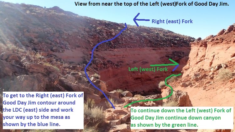
To get to the Right (east) Fork of Good Day Jim contour around the
LDC (east) side and work your way up to the mesa as shown by the
blue line.
To continue down the Left (west) Fork of Good Day Jim continue down
canyon as shown by the green line.
Approach to the
Right Fork:
From the top of the Left
(west) Fork of Good Day
Jim (yGoodDayLFTp) do
not drop downclimb the
15 foot drop at the head
of the canyon.
Instead contour around
the LDC (east) side of
the drainage and travel
southeast about 500 feet
working your way up to
the mesa above to the
southeast.
Once on the mesa top
(wGoodDayRP-20) route
find your way south
about 350 feet until you
get to the rim looking
over the Right (east)
Fork of Good Day Jim
(wGoodDayRP-21).
When you get to the rim
of the Right Fork of
Good Day Jim route find
your way east and down
to the head of the Right
(east) Fork about 450
feet away (yGoodDayRFTp).
To follow the
description for the
Right (east) Fork, skip
to the Right (east) Fork
Canyoneering / Technical
Section.
The Left (west)
Fork Canyoneering /
Technical Section:
The drop at the
start of Good Day Jim (yGoodDayLFTp)
is about 15 feet and can
be downclimbed on the
RDC side. The
downclimb is easier than
it looks but is still a
little sketchy.
Consider providing a
meat anchor for all but
the last who can then
downclimb.
About 750 feet down
canyon is a drop
in the whitish sandstone
with a very short slot
(wGoodDayRP-03).
The canyon is very wide
open here making it easy
to bypass this slot.
About 700 feet farther
is the start of trough
like slot that gradually
gets deeper and more
narrow (wGoodDayRP-04).
Galumphing is required
to continue down canyon.
There are 3 downclimbs
of up to 12 feet each
over the next 1000 feet
before reaching rap 1.
Rap 1 (dGoodDayR1) is
anchored from a rock
about 15 feet back and
drops about 15 feet to a
pothole about 6 feet
deep with a sand
bottom. The pothole
would be a swimmer for
about 8 feet if full.
If dry rap 1 can be
downclimbed.
On the other side of the
pothole below rap 1 is a
short downclimb then a
rock fall debris area.
On the other side of the
rock fall debris is
another pothole and is
the one that has been 15
feet deep in the past
and still had a sand
filled bottom. We
found it at only 5 feet
deep in 2013 then
scoured out very deep
again in 2014.
If sand scours out
leaving a deep keeper
you will need to toss
potshots to help climb
out.
On the other side of the
keeper pothole is a steeply
sloped downclimb of
about 20 feet to another
shallow pothole that is
easy to cross.
A few hundred feet down
canyon is where side
drainages drop in from
both RDC and LDC (jGoodDayConf).
The side drainage coming
in from LDC (east) is
the Right (east) Fork of
Good Day Jim.
To continue skip down to
the section for the
technical section below
the confluence of the
Right and Left Forks.
The Right (east)
Fork Canyoneering /
Technical Section:
At the head of the Right
Fork of Good Day Jim (yGoodDayRFTp)
is a drop of about 15
feet. This drop
will be a rappel for
most people but can be
downclimbed by skilled
downclimbers. If
rappelled the drop can
be anchored from one of
many rock.
After Rap 1 in the Right
Fork at the head of the
canyon continue
southwest down canyon in
wide open spaces.
About 450 feet down
canyon is the top end of
a slot (wGoodDayRP-22)
where drop down into the
Navajo layer. The slot
is about 250 feet long
and has light galumphing
and a few easy
downclimbs of 6 to 8
feet each.
After the short slot is
more wide open walking
for about 500 feet down
to the start of another
slot (wGoodDayRP-23).
Travel down the slot is
easy galumphing and 3
easy downclimbs of 4 to
10 feet each.
About 200 feet down this
slot is a sharp left
right jog in the canyon.
Just after the sharp
left right jog in the
canyon is the top of a
series of 3 downclimbs
(wGoodDayRP-24).
The first is about 25
feet high and is an
elevator style
downclimb. A few
feet down canyon is the
second downclimb of
about 20 feet that is
also an elevator style
downclimb. Just at
the bottom of the second
down climb is the top of
the third downclimb
about 15 feet high.
Shortly down canyon of
the series of 3
downclimbs is a
downclimb of about 5
feet where the deep slot
you are in opens up into
a large cross joint at a
sharp left turn.
Follow the cross joint
for about 150 feet to a
sharp right turn. Then
another 500 feet down to
the confluence of the
Left and Right Forks of
Good Day Jim Canyon.
Note:
After dropping down to
the confluence you can
take a short side trip
up to the keeper pothole
to take a look if you
like. To do so
turn right and walk
north up canyon about
200 feet and scramble up
to the the bottom end of
the keeper pothole.
As you look up canyon of
the confluence it looks
like there are two
drainages coming down.
The right drainage is
the one you want to go
up.
The Canyoneering
/ Technical Section
below confluence of the
Right and Left Forks:
From the confluence of
the Right and Left Forks
of Good Day Jim (jGoodDayConf)
walk about 250 feet
south down
canyon to a 15 foot
downclimb into a sand
filled pothole.
The pothole below is
about 3 feet deep but
has an overhanging down
canyon lip and would be
a keeper if sand is
scoured out. in
the pothole is a deadman
to anchor rap 2.
Rap 2 (dGoodDayR2-3) is
anchored from a rock or
deadman anchor in a
small shallow pothole.
With the webbing
extended about 15 feet
over to the drop down
into a large pothole it
will take about 90 feet
of rope travel to rap
down and through 3 large
potholes in a row. After
the 3 large potholes is
another small pothole
just before a short slot
/ crack where the anchor
for rap 3 will be.
Portions of rap 2 may be
downclimbed and the
large potholes may be
sand filled making
rappel not needed in
some portions.
However if the canyon is
wet anchor options in
the potholes are
difficult. Plan on
using the 90 feet of
rope travel to bypass
all three large potholes
as a single rap which
will get you through in
all conditions.
Rap 3 is anchored from a
rock or dead man in the
small pothole after the
3 large potholes you
passed while on rap 2.
Rap 3 drops about 20
feet down to another
large pothole where
there is a slot
downclimb on the other
side.
After rap 3 the canyon
goes through a section
of twisty walled narrows
for about 100 feet then
travel becomes easy as
you navigate the turns
of a cross jointed
section. While
navigating through the
cross jointed section
there will be a couple
narrow corridors and a
couple downclimbs of 15
to 20 feet.
About 300 feet down
canyon of rap 3 is a
large pothole that may
be deep if the sand has
been scoured out
(wGoodDayRP-30).
This pothole can be
bypassed RDC by going up
and around on a very
chossy ledge.
About 500 feet farther
down canyon is a massive pothole
(wGoodDayRP-31) just
after making a left turn.
The massive pothole has a slot
like shape on the up
canyon side where you
could climb down into it
easily but the down
canyon side would likely
be a keeper. The
pot hole is long enough
that it would be very
difficult to toss a
potshot far enough.
This pothole is easily
bypassed by scrambling
steeply up on a ledge on the RDC
sided, walking the ledge
then a short downclimb
back to the canyon floor
after passing the
pothole.
After the massive
pothole the canyon turns
right then left then
right again through
cross joints. At
the second right will be
a short section of
downclimbs before
getting to the top of
rap 4.
Rap 4 (dGoodDayR4) is
anchored from a choke
stone at the top of the
drop and drops about 25
feet down a vertical
wall into a pothole
chamber. The
pothole at the bottom
would be a swimmer if
full. At the top
of rap 4 is a cross
joint on the RDC side
with rock features and
some vegetation that can
also provide anchors.
Note:
The cross joint on the
RDC side at the top of
rap 4 looks like it may
provide an escape from
the canyon up to join
the exit route.
This has not been
confirmed though.
A few hundred feet down
canyon of rap 4 is the
start of a skinny
section. The start
of the skinnies offers a
good place to practice
galumphing about 10 feet
off the deck or you can
drop down to the bottom
and work through the
skinny stuff below.
Most people will want to
remove their pack at the
bottom. Part way
through the skinny
section is some boulder
debris with a rabbit
hole to crawl through
under some of the
boulders. Just
before the end of the
skinny section is a
pothole to cross that
would be a swimmer if
full and might be a
little difficult to get
out of if wet.
After the pothole the
skinny section ends
(wGoodDayRP-32) where
you find yourself
looking down to a ledge
and to the wider canyon
below that turns sharp
left. Downclimbing
the 6 feet to the ledge
can be a little
difficult since there is
little room to maneuver.
After downclimbing onto
the ledge you can slide
down a 15 foot slope to
the canyon floor or turn
left and walk the ledge
about 300 feet to the
confluence of the Good
Day Jim and Hard Day
Harvey routes (jGoodHardConf).
About 250 or 300 feet
down canyon of the
confluence is the top of
the final rap for both
the Hard Day Harvey and
Good Day Jim routes.
Rap Final (dGoodHardR1) is about
300 feet down canyon of
the confluence, is anchored from
one of many boulders and
drops about 35 feet down
over boulder debris with
a short section of free
hang.
Continuing down canyon
after the final rap is
easy travel in wide
canyon with some easy
scrambles over boulder
debris.
About 0.3 miles down
canyon of the final rap
the canyon opens up very
wide after a dense
section of boulder
debris (wGoodHardRP-01).
Continuing down canyon
is more easy travel with
some easy scrambling to
get over boulders for
0.3 miles to the top of
a 50 foot drop in the
wash (yGoodHardBt).
This is the end of the
canyon section for both
the Good Day Jim and
Hard Day Harvey routes.
The Exit:
There are
two exit options out of
Good Day Jim and Hard
Day Harvey; East Exit
and West Exit. The
West exit is described
here. For
information on the East
exit see the Hard Day
Harvey route
description.
For the West Exit:
From the 50 foot drop
walk up onto a ledge /
shelf on the RDC (West)
side. Look for and
follow a use trail
following along the
large shelf.
About 500 feet after you
have left the trail will
travel through a rock
debris area as it goes
around a point. In
this rock debris area
the trail seems to
disappear.
Continue through the
rock debris staying as
high as possible and
look for the well
defined trail to
continue on the other
side.
About 700 feet farther
you will pass a small
ravine like feature on
the cliffs to your right
(wGoodWestRP-01).
This is not the way up,
continue south along the
use trail for the exit
of the Good Day Hard Day
routes.
About 600 feet farther
will be a much larger
ravine going up through
the cliffs on the right
(wGoodWestRP-02).
This larger ravine /
drainage is the one used
for the exit route up to
the mesa top above.
Note:
The use trail you have
been following continues
south along the shelf
you are on. Keep
your eye open for your
exit ravine up the cliff
band. If you just
follow the trail not
looking for where you
need to leave it you may
end up somewhere you
don't want to be.
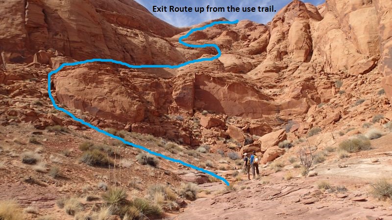
The blue line shows the route up the ravine from the use trail.
To start up the ravine
from the use trail go up
the left (south) side
and work up some rock
debris to get up to a
small shelf like feature
leading up the left side
of the ravine.
Route find your way
mostly along the left
side of the ravine
following the blue line
in the image above.
About half way up the
ravine you will need to
do an S curve to
transition to the next
higher shelf
(wGoodWestRP-03).
The S curve is shown in
the image above with the
blue line.
Shortly after doing the
S curve to get up on the
next higher shelf will
be a chute then steeply
sloped slick rock.
Continue route finding
your way northwest up
the steeply sloped slick
rock.
About 600 feet after the
S curve area will the
start of a vertical wall
(wGoodWestRP-04).
Continue northwest along
the base of the vertical
wall.
About 700 feet farther
the route tops out next
to a small sandstone
peak (wGoodWestRP-05).
From the top out veer
more right and travel
north along the
sandstone ridge.
As you travel along the
ridge from the top out
you will have a view of
Mount Ellsworth in the
distance. Just
right of Mount Ellsworth
look for a reddish
sandstone cap due north
about 0.35 miles away.
Route find your way
across the wide open
sandstone ridge toward
the sandstone cap.
On the way over to the
red sandstone cap you
will cross over a saddle
and need to navigate
around a couple areas.
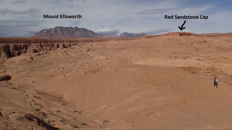
As you top out on the exit look for Mount Ellsworth then a red
sandstone cap due north about 0.35 miles away. Route find your
way to the red sandstone cap.
When you get to the base
of the red sandstone cap
(wGoodWestRP-06), go
right and travel along
the base of the cliffs
on the right (east)
side. As you
travel along the base of
the cliff looking to the
right (east) will give
you great views down
over the Good Day Jim
and Hard Day Harvey
routes.
About 1000 feet along
the base of the cliff
will be the bottom of a
break (wGoodWestRP-07)
where you can climb up
to the top.
Scramble up the dirt and
rubble to get to the
mesa top
(wGoodWestRP-08).
Once on the mesa top
(wGoodWestRP-08) follow
the very wide ridge like
dirt mesa top as it
travels north then
slowly trends more
northeast over the next
1.3 miles back to the
road and your car.
As you get about 0.5
miles from the cars the
area will start to widen
out and not have a ridge
like feel
(wGoodWestRP-09).
As the ridge widens out
begin to veer more
northeast and stay high
where possible to make
travel easier back to
the where you parked the
cars (pkGoodDayJim).
Downloadable GPX files
available at
BG-Gear Store
(easier than manual entry and a great way to support
Bluugnome).
Waypoint naming convention and map symbol information can be found on the Glossary page.
Elevations are approximate.
BEFORE
manually entering coordinates set your system to WGS84 datum and Lat/Lon hddd.ddddd° coordinate format.
Inconsistent datum's and coordinate formats will result in location errors.
Click to show / expand the list of waypoints below........
| Good Day Jim (1) - Drive in to trailhead |
- extTicaboo1
Lat/Lon (WGS84): N 37.69720
W -110.67138
Elev: 4,520 Feet
Exit off of highway 276 to get to the Ticaboo Mesa area. Turn east and leave the highway on a dirt road. Near Mile post 25.
- TicabooDP-01
Lat/Lon (WGS84): N 37.68607
W -110.65188
Elev: NaN Feet
Continue straight for the main area of Ticaboo Mesa. Or Turn right (south) here for an alternate route over toward the Smith Fork Canyons.
- TicabooDP-02
Lat/Lon (WGS84): N 37.67981
W -110.62886
Elev: NaN Feet
Road junction with faint road running to the south. Continue straight (east).
Road to the south is about 1.25 miles long and goes down toward Cane Spring Well.
- TicabooDP-03
Lat/Lon (WGS84): N 37.68038
W -110.62628
Elev: 4,565 Feet
Exit to a spot to camp if the roads ahead are too rough.
- TicabooDP-04
Lat/Lon (WGS84): N 37.67963
W -110.60429
Elev: NaN Feet
Junction for a road going south. Continue straiaght (north east) to continue toward Ticaboo Measa. This road junction is near Wild Horse Springs.
- TicabooDP-05
Lat/Lon (WGS84): N 37.68389
W -110.60153
Elev: NaN Feet
Junction for a side road on the left going north. Continue north east toward Ticaboo Mesa.
The road going north is BLM Road 13440 aobut 0.4 miles long and goes over toward Colt Spring.
- TicabooDP-06
Lat/Lon (WGS84): N 37.68667
W -110.59547
Elev: NaN Feet
Junction for a side road going north.
The Road north is BLM Road 13540 and goes out toward Upper South Fork Ticaboo.
- TicabooDP-07
Lat/Lon (WGS84): N 37.69529
W -110.58385
Elev: NaN Feet
Turn off for a side road on the right. Turn right onto the side road and drive southwest.
- extWarmSpring
Lat/Lon (WGS84): N 37.69362
W -110.58484
Elev: NaN Feet
Stay right to go toward the main drainage of Seven Mile Creek and Warm Springs Canyon. Or Stay left to go toward the East Branch of Seven Mile Creek and Ticaboo Mesa.
- ext7MileCkEB
Lat/Lon (WGS84): N 37.69147
W -110.58014
Elev: NaN Feet
Turn right (more south) to continue toward the East Branch of Seven Mile Creek. Or veer left to continue toward Ticaboo Mesa.
- 7MileCkEBDP-01
Lat/Lon (WGS84): N 37.68044
W -110.56997
Elev: NaN Feet
Continuestraight (south) past a side road joining from the left. This road is not shown on all maps.
- 7MileCkEBDP-02
Lat/Lon (WGS84): N 37.67443
W -110.56735
Elev: NaN Feet
Jog in the road near a stock pond. Veer right and continue south. Turning left leads to a berm with a survey marker on it.
- pkGoodDayJim
Lat/Lon (WGS84): N 37.66517
W -110.55946
Elev: 4,860 Feet
Park here for Good Day Jim. There is no pull out so just park to the side of the road. This spot is next to a wash about 0.75 miles past the stock pond. Good Day Jim is the West Fork of the East Branch of Seven Mile Creek.
|
| Good Day Jim (2) - Approach to top of Left (west) Fork |
- pkGoodDayJim
Lat/Lon (WGS84): N 37.66517
W -110.55946
Elev: 4,860 Feet
Park here for Good Day Jim. There is no pull out so just park to the side of the road. This spot is next to a wash about 0.75 miles past the stock pond. Good Day Jim is the West Fork of the East Branch of Seven Mile Creek.
- wGoodDayRP-01
Lat/Lon (WGS84): N 37.66345
W -110.56425
Elev: NaN Feet
Dry fall of about 10 feet to walk around.
- wGoodDayRP-02
Lat/Lon (WGS84): N 37.66250
W -110.56616
Elev: NaN Feet
Dry fall of about 8 feet that is easily scrambled down.
- yGoodDayLFTp
Lat/Lon (WGS84): N 37.66089
W -110.56786
Elev: 4,680 Feet
Top of the Left (west) Fork of Good Day Jim. This is just after the canyon begins to slot up and there is a 15 foot drop here.
To go down the Left (west) Fork of Good Day Jim downclimb the drop on the RDC side then continue down canyon. The downclimb is a little sketchy but is easier than it looks.
To go over to the Right (east) Fork of Good Day Jim do not climb down the 15 foot drop. Instead contour around the LDC (east) side of the drainage and travel southeast about 500 feet working your way up to the mesa above to the southeast.
|
| Good Day Jim (3) - Route from top of Left (west) Fork to top of Right (east) Fork |
- yGoodDayLFTp
Lat/Lon (WGS84): N 37.66089
W -110.56786
Elev: 4,680 Feet
Top of the Left (west) Fork of Good Day Jim. This is just after the canyon begins to slot up and there is a 15 foot drop here.
To go down the Left (west) Fork of Good Day Jim downclimb the drop on the RDC side then continue down canyon. The downclimb is a little sketchy but is easier than it looks.
To go over to the Right (east) Fork of Good Day Jim do not climb down the 15 foot drop. Instead contour around the LDC (east) side of the drainage and travel southeast about 500 feet working your way up to the mesa above to the southeast.
- wGoodDayRP-20
Lat/Lon (WGS84): N 37.65993
W -110.56860
Elev: NaN Feet
Up on the mesa after getting up out of the Left (west) Fork of Good Day Jim. To go to the Right (east) Fork route find your way south across the mesa about 350 feet until you reach the rim of the Right Fork.
- wGoodDayRP-21
Lat/Lon (WGS84): N 37.65902
W -110.56831
Elev: NaN Feet
On the rim of the Right (east) Fork of Good Day Jim. Route find your way east and down to the head of the Right Frok about 450 feet away.
- yGoodDayRFTp
Lat/Lon (WGS84): N 37.65895
W -110.56670
Elev: 4,680 Feet
Top of the Right (east) Fork of Good Day Jim.
A drop here of about 15 feet will be a rappel for most people but skilled downclimbers can downclimb the drop. If rappelled and anchor can be set from one of many rocks.
|
| Good Day Jim (4) - Left (west) Fork down to Confluence |
- yGoodDayLFTp
Lat/Lon (WGS84): N 37.66089
W -110.56786
Elev: 4,680 Feet
Top of the Left (west) Fork of Good Day Jim. This is just after the canyon begins to slot up and there is a 15 foot drop here.
To go down the Left (west) Fork of Good Day Jim downclimb the drop on the RDC side then continue down canyon. The downclimb is a little sketchy but is easier than it looks.
To go over to the Right (east) Fork of Good Day Jim do not climb down the 15 foot drop. Instead contour around the LDC (east) side of the drainage and travel southeast about 500 feet working your way up to the mesa above to the southeast.
- wGoodDayRP-03
Lat/Lon (WGS84): N 37.65958
W -110.56971
Elev: NaN Feet
Very short slot in the whitish sandstone. The canyon is very wide here making it easy to bypass this slot.
- wGoodDayRP-04
Lat/Lon (WGS84): N 37.65818
W -110.57119
Elev: 4,570 Feet
Start of a shallow trough that gradually gets deeper and narrower. Galumphing is required for travel down canyon. There are 3 downclimbs of up to 12 feet each over the next 1000 feet before reaching rap 1.
- dGoodDayR1LF
Lat/Lon (WGS84): N 37.65545
W -110.57109
Elev: 4,470 Feet
Rap 1 - Good Day Jim Left Fork. Anchored from a rock about 15 feet back and drops about 15 feet to a pothole about 6 feet deep with a sand bottom. The pothole would be a swimmer for about 8 feet if full. If dry rap 1 can be downclimbed.
On the other side of the pothole below rap 1 is a short downclimb then a rock fall debris area. On the other side of the rock fall debris is another pothole and is the one that has been 15 feet deep in the past and still had a sand filled bottom. We found it at only 5 feet deep in 2013 then scoured out very deep again in 2014. If sand scours out leaving a deep keeper you will need to toss potshots to help climb out.
- jGoodDayConf
Lat/Lon (WGS84): N 37.65479
W -110.57105
Elev: 4,400 Feet
Side drainages come in fromn both RDC and LDC. The draiange on the LDC side is wehre you drop in if taking the bypass route to drop in below the keeper. This is a few hundred feet down canyon of a pothole that has long been a deep keeper but was only 5 feet deep in Mar. 2013
|
| Good Day Jim (5) - Right (east) Fork down to Confluence |
- yGoodDayRFTp
Lat/Lon (WGS84): N 37.65895
W -110.56670
Elev: 4,680 Feet
Top of the Right (east) Fork of Good Day Jim.
A drop here of about 15 feet will be a rappel for most people but skilled downclimbers can downclimb the drop. If rappelled and anchor can be set from one of many rocks.
- wGoodDayRP-22
Lat/Lon (WGS84): N 37.65846
W -110.56812
Elev: NaN Feet
Top end of a slot where drop down into the navajo layer. The slot is about 250 feet long and has light galumphing and a few easy downclimbs of 6 to 8 feet each. After the slot is about 500 feet of wide open walking down to the start of the next slot.
- wGoodDayRP-23
Lat/Lon (WGS84): N 37.65684
W -110.56932
Elev: NaN Feet
Top of a slot with easy galumphing and 3 easy downclimbs of 4 to 10 feet each. About 200 feet down this slot is a sharp left right jog in the canyon.
- wGoodDayRP-24
Lat/Lon (WGS84): N 37.65635
W -110.56968
Elev: NaN Feet
Top of a series of 3 downclimbs. The first is about 25 feet high and is an elevator style downclimb. A few feet down canyon is the second downclimb of about 20 feet that is also an elevator style downclimb. Just at the bottom of the second down climb is the top of the third downclimb about 15 feet high. A short distance after this series of 3 downclimbs is a drop of about 5 feet where the deep slot you are in opens up into a wide cross joint where you take a sharp left trun.
- jGoodDayConf
Lat/Lon (WGS84): N 37.65479
W -110.57105
Elev: 4,400 Feet
Side drainages come in fromn both RDC and LDC. The draiange on the LDC side is wehre you drop in if taking the bypass route to drop in below the keeper. This is a few hundred feet down canyon of a pothole that has long been a deep keeper but was only 5 feet deep in Mar. 2013
|
| Good Day Jim (6) - The Canyon from Confluence down |
- jGoodDayConf
Lat/Lon (WGS84): N 37.65479
W -110.57105
Elev: 4,400 Feet
Side drainages come in fromn both RDC and LDC. The draiange on the LDC side is wehre you drop in if taking the bypass route to drop in below the keeper. This is a few hundred feet down canyon of a pothole that has long been a deep keeper but was only 5 feet deep in Mar. 2013
- dGoodDayR2-3
Lat/Lon (WGS84): N 37.65412
W -110.57084
Elev: NaN Feet
Raps 2 and 3 - Good Day Jim.
Rap 2 is anchored from a rock or deadman anchor in a small shallow pothole. With the webbing extended about 15 feet over to the drop down into a large pothole it will take about 90 feet of rope travel to rap down and through 3 large potholes in a row. After the 3 large potholes is another small pothole just before a short slot / crack where the anchor for rap 3 will be.
Portions of rap 2 may be downclimbed and the large potholes may be sand filled making rappel not needed in some portions. However if the canyon is wet anchor options in the potholes are difficult. Plan on using the 90 feet of rope travel to bypass all three large potholes as a single rap which will get you through in all conditions.
Rap 3 is anchored from a rock or dead man in the small pothole after the 3 large potholes you passed while on rap 2. Rap 3 drops about 20 feet down to another large pothole where there is a slot downclimb on the other side.
- wGoodDayRP-31
Lat/Lon (WGS84): N 37.65193
W -110.57066
Elev: NaN Feet
Massive pothole. Part way through the cross jointed section is a massive pothole that would be very difficult to cross and get out of. Bypass this pothole on the RDC side by scrambling up to the ledge on the RDC side then back down to the canyon floor just after it.
- dGoodDayR4
Lat/Lon (WGS84): N 37.65074
W -110.57093
Elev: NaN Feet
Rap 4 - Good Day Jim. Anchored from a choke stone at the top of the drop or from features up in the cross joint on the RDC side. Rap 4 drops about 25 feet down into a pothole chamber. The cross joint on the RDC side looks like it might provide an exit from the canyon but this is not confirmed.
- wGoodDayRP-3
Lat/Lon (WGS84): N 37.64828
W -110.57200
Elev: NaN Feet
Skinny section ends where you find yourself looking down a ledge into the wide open canyon that jogs sharp left. Dwonclimb about 6 feet out onto the next ledge tehn make your way down to teh confluence with Hard Day Harvey.
- jGoodHardConf
Lat/Lon (WGS84): N 37.64754
W -110.57159
Elev: 4,020 Feet
Confluence of Good Day Jim and Hard Day Harvey.
- dGoodHardR1
Lat/Lon (WGS84): N 37.64752
W -110.57250
Elev: NaN Feet
Rap 1 below confluence of Good Day Jim and Hard Day Harvey. Final rap and is about 250 to 300 feet down canyon of the confluence. Anchored from one of many boulders at the top of the drop and drops about 35 feet along boulder debris.
- wGoodHardRP-01
Lat/Lon (WGS84): N 37.64449
W -110.57514
Elev: NaN Feet
Canyon opens up wider after a dense section of boulder debris.
- yGoodHardBt
Lat/Lon (WGS84): N 37.64100
W -110.57405
Elev: 3,770 Feet
Bottom exit of both the Hard Day Harvey route and the Good Day Jim route. This is the top of a 50 foot drop in the wash.
|
| Good Day Jim (7) - Exit |
- yGoodHardBt
Lat/Lon (WGS84): N 37.64100
W -110.57405
Elev: 3,770 Feet
Bottom exit of both the Hard Day Harvey route and the Good Day Jim route. This is the top of a 50 foot drop in the wash.
- wGoodWestRP-01
Lat/Lon (WGS84): N 37.63784
W -110.57400
Elev: NaN Feet
Ravine like feature on the cliffs to the right. This is not the way up. For exiting the Good Day / Hard Day routes continue south along the use trail.
- wGoodWestRP-02
Lat/Lon (WGS84): N 37.63664
W -110.57512
Elev: 3,790 Feet
Start of the ravine exit leaving the use trail. Travel mostly up the left side of the ravine.
- wGoodWestRP-03
Lat/Lon (WGS84): N 37.63765
W -110.57646
Elev: NaN Feet
A spot along the exit ravine where you need to do an S curve to transition to the next higher shelf.
- wGoodWestRP-04
Lat/Lon (WGS84): N 37.63891
W -110.57768
Elev: NaN Feet
Start of a vertical wall. Continue northwest following along the base of the vertical wall.
- wGoodWestRP-05
Lat/Lon (WGS84): N 37.64056
W -110.57874
Elev: 4,460 Feet
The exit climb up tops out here. From this point trend a little bit right following the ridge line north.
- wGoodWestRP-06
Lat/Lon (WGS84): N 37.64832
W -110.57629
Elev: 4,560 Feet
At the base of the red sandstone cap. Travel along the base of the cliffs on the right (east) side for about 1000 feet to a break where you can climb up to the top.
- wGoodWestRP-07
Lat/Lon (WGS84): N 37.65101
W -110.57422
Elev: NaN Feet
Bottom of a break in the cliff band where you can climb up to the mesa top.
- wGoodWestRP-08
Lat/Lon (WGS84): N 37.65134
W -110.57444
Elev: 4,650 Feet
Top of the break used to access the mesa top.
- wGoodWestRP-09
Lat/Lon (WGS84): N 37.66265
W -110.56685
Elev: NaN Feet
Area widens out no longer having a wide ridge feel. As you get here you are about 0.5 miles from the cars. Veer north east and stay high where you can to make travel easier.
- pkGoodDayJim
Lat/Lon (WGS84): N 37.66517
W -110.55946
Elev: 4,860 Feet
Park here for Good Day Jim. There is no pull out so just park to the side of the road. This spot is next to a wash about 0.75 miles past the stock pond. Good Day Jim is the West Fork of the East Branch of Seven Mile Creek.
|