Canyoneering Route Description
Fiddlestix Canyon - 3A II (III)
Ticaboo Mesa, Utah.
11-04-2012, 6 people, 1 Day (Travel time in route 4 hours)

02-23-2014, 6 people, 1 Day (Travel time in route 4 hours)
05-28-2016, 5
people, 1 Day (Travel time in route 4.75 hours)
Time Required - 3 to 4 hours
Distance - 1.8 miles Total, 0.6 miles Technical
Rappels - 3 Rappels, Longest Rappel 185 feet.
Elevation Range - 4975 - 4115 Feet
Shuttle Required - No Vehicle -
High Clearance (4WD in bad road conditions)
Permit Required - No
This route description provides minimal detail in the canyon section.
Rappelling and anchor gear, Ropes and or pull cords for rappels up
to 185 feet and 30 feet of 1 inch webbing for sling placement.
Only in very cold months after recent rains a waist down wet suit
may be nice. Generally no wet suit would be needed.
Fiddlestix is short but offers a lot of fun in that
short distance. Rap 2 can have serious issues with ropes sticking on
the pull and may be best broken up into a couple raps to help reduce rope
sticking. Also at the bottom of rap 2 the canyon takes on the
deep narrow feel that is very committing feeling. Using a Fiddlestick
or retrievable anchor on the drops can be helpful in reducing rope grooves.
Fiddlesticks offers galumphing to 15 feet off the deck
and down climbs of up to 30 feet with moderate difficulty. There are a
few potholes that could be waist deep if full and easy to get out of but
they generally will not have much if any water in them. And did I
mention a sandy bottomed corridor of about 200 feet?
To get to the Trailhead
Note:
There is a maze of roads on Ticaboo Mesa making it a good idea
to study the map ahead of time and keep a close eye on the map
as you drive.
From Hanksville, UT., drive south on highway 95 for 26 miles to
the junction of highways 95 and 276.
From the junction, drive south on HWY-276 for 25.6 miles then
turn left (east) onto BLM dirt-road 13400 between mile markers
25 and 26 (extTicaboo1).
About 1.5 miles from the highway is a junction (TicabooDP-01)
of BLM roads, 13400 continues east and 13410 branches off to the
south. Continue east on BLM road 13400. Note: If you were headed
to the Smith Fork area you would turn south onto BLM road 13410.
About 2 miles farther is another junction
(TicabooDP-02) of BLM roads, 13400 continues east and 13420
branches off to the south. Continue east on BLM road 13400.
Note: BLM road 13420 to the south goes out to Cane Spring Well
about 1.25 miles south.
About 0.2 miles farther is short side road (TicabooDP-03) on the
left (north) that goes to a camp area.
Stay right to
continue on BLM road 13400. Beyond this point the roads
will have intermittent rough sections.
About 0.37
miles past here is a fork in the road where the two roads rejoin
a short distance later. The low road is typically the
smoothest.
About 1.7 miles farther is another junction (TicabooDP-04) of
BLM roads (13400 continues north-ish and 13430 branches off to
the south).
Continue north on BLM road 13400.
Note: If you were going to the roads between Warm Springs Creek
and Sevenmile Creek, you would turn south onto BLM road 13430.
About 0.3 miles farther is another junction (TicabooDP-05) of
BLM roads (13400 continues northeast and 13440 branches off to
the north).
Continue straight northeast on BLM road 13400.
Note: BLM road 13440 to the south goes out to Colt Spring Well
about 0.4 miles north.
About 0.5 miles farther is a junction (TicabooDP-06) of BLM
roads (13400 continues northeast and 13450 branches off to the
north).
Continue straight northeast on BLM road 13400.
About 0.9 miles farther is a junction (TicabooDP-07) of BLM
roads (13400 continues northeast and 13430 branches off to the
south).
Turn south onto BLM road 13430.
Note: If you were
going to Tough, SF Ticaboo or Sleepytime Trio Canyons you would
continue northeast on BLM road 13400.
About 700 feet farther is a fork in the road (extWarmSpring).
At this fork stay left to continue toward the East Branch of
Seven Mile Creek.
About 0.4 miles farther is another fork in the road
(ext7MileCkEB). Veer left (east) to continue toward the
Dante's.
About 1.1 miles farther is a junction where a side road joins in
from the southwest (TicabooDP-08). Veer left (east) to
continue toward the Dante's.
About 0.4 miles farther is a junction where a side road joins in
from the southwest (extTicabooMesa). Turn right at this
junction and follow the road south.
About 0.9 miles farther is a junction (TicabooDP-21). Turn
left at this junction and follow the road east. Shortly
after the junction the road will little then travel southeast.
About 0.9 miles from the junction the road will round a
corner (pkFidlStix) to the left where it turns from southwest to
southeast. This corner is where you will begin the route
to Fiddlestix. There are no designated spots to park and
you will likely need to be creative to find a good spot to get
off the road.
To leave the Exit Vehicle / Escape Pod
No exit vehicle is needed. This is done as a loop route.
GPS coordinate information listed at the bottom. For information about waypoint naming and map symbols, refer to the
Glossary page.

Click the links for maps of the route.
Map of the drive into the route.
Map of the entire route.
The Approach:
From the parking spot (pkFidlStix),
walk about 400 feet west
to a rubble pile
(wFidlStixRP-01) that
allows travel down to the shelf
below.
After getting to the
bottom of the rubble
pile continue southeast
toward the portion of
the lake you can see.
Follow the natural flow
of the slick rock for
about 900 feet to the
top of a large crack
(wFidlStixRP-02).
You can travel on a fin
on either side of this
crack but the easiest is
the fin on the left
(north) side.
Continue southeast for
about 375 feet to a wide
open flat slick rock
area where a drainage
begins (yFiddlestixTp)
dropping down to the
northeast.
Note:
There is a drop up
canyon of this about 150
feet southeast but there
is little to it and may
not be worth the effort
of getting up to it.
The Canyoneering / Technical Section:
From the head of
the canyon (yFiddlestixTp)
continue down canyon
northwest.
Rap 1 (dFiddlestixR1)
is about 300 feet down
canyon of the head, is
anchored from a small
arch about 8 feet up on
the RDC side and drops
about 35 feet.
Rap 2 is shortly down
canyon of rap 1 and is
anchored from boulder
debris in a narrow
section and drops about
75 feet. To make
the rope pull smooth and
less likley to get stuck
the last person can
rappel over the top of
the boulders instead of
down the crack on the
LDC side. Rap 2 can also
be broken into two
separate rappels by
rappelling down about 10
feet to choke stones and
ledges to re-anchor and
continue the drop.
Down canyon of rap 2 is
a pretty section of
canyon with some easy
downclimbs / low
galumphing.
Last Rap (dFiddlestixR3)
is about 450 feet down
canyon of rap 2 anchored from
a large chock stone and
a few other rocks to
help support it.
Anchor to bottom about
185 feet with first part
being more of a scramble
on rope then down a
mostly vertical drop
with a ledge part way
down. At
bottom of the last rap is a
pool, but you can
traverse carefully LDC then up the slick
rock to a ledge to avoid
water.
If the large pool
is dried up walk the
sand about 70 feet to a
downclimb of about 10
feet then walk the wash.
After the last rap
follow the canyon as it
winds east for about 0.4
miles to tees into
another drainage (yFiddlestixBt).
The Exit:
From tee
at the end of Fiddlestix
(yFiddlestixBt) there is
a prominent point about
200 feet east with a
ridge line running up
and northwest. The
exit out of Fiddlestix
is along that ridge.
From the tee walk about
150 feet north up the
wash then leave the wash
and walk east about 150
feet over to the bottom
of a gully
(wFidlStixRP-03) to
upclimb to get part way
up onto the ridge.
After climbing to the
top of the gully turn
left and follow the
ledges north. As
you follow the ledges
traversing north there
are a couple spots to
step across missing
spots in the ledge with
significant exposure but
the moves are not
difficult.
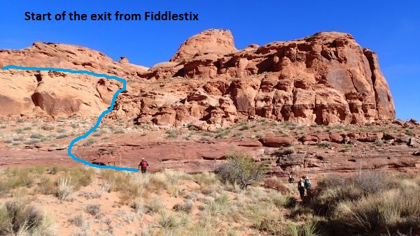
Blue line shows the
route up the gully
and along the first
part of the ledges
to start the exit
from Fiddlestix.
Soon the ledges lead
over to wide open flat
spaces on a saddle like
area. From this
saddle like area
continue north for about
600 feet to the bottom
of a slick rock nose
(wFidlStixRP-04).
Go up the slick rock
nose and where it
becomes extremely steep
traverse left to skirt
around the high point of
the nose as shown in the
picture below.
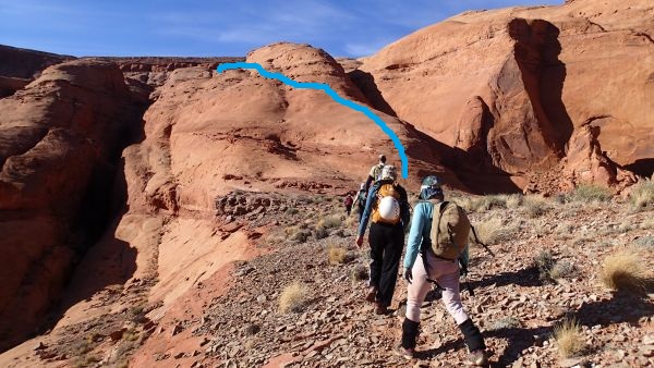
Blue line shows the
route up the slick
rock nose and
approximately where
to traverse left.
As you traverse along
the left side of the
slick rock nose in the
image above you will
have an easy upclimb of
about 4 feet when you
get near the high point
of the slickrock
(wFidlStixRP-05).
A few hundred feet
farther will be a spot
(wFidlStixRP-06) where
you have a wide drainage
to the left (south)
below you or a sandy
open area to the right
(north) side of another
slick rock nose. Veer
left (south) and drop
down into the large
drainage below.
Walk up the drainage
about 250 feet then
scramble up the steep
slickrock ramp
(wFidlStixRP-07) to get
out of the drainage.
From the top of the ramp
route find your way up
and about 400 feet west
to the bottom of a slick
nose (wFidlStixRP-08).
Scramble up the
slickrock nose about 850
feet to the top
(wFidlStixRP-09) where
you will be on a dirt
bench below the rim.
From the top of the
slickrock nose veer left
and walk about 250 feet
southwest along the dirt
bench to the bottom of a
rubble pile
(wFidlStixRP-10).
Scramble up the rubble
pile and then up to the
road (wFidlStixRP-11).
After you make it to the
road turn left and
follow the road 0.33
miles southwest back to
where you parked (pkFidlStix).
Downloadable GPX files
available at
BG-Gear Store
(easier than manual entry and a great way to support
Bluugnome).
Waypoint naming convention and map symbol information can be found on the Glossary page.
Elevations are approximate.
BEFORE
manually entering coordinates set your system to WGS84 datum and Lat/Lon hddd.ddddd° coordinate format.
Inconsistent datum's and coordinate formats will result in location errors.
Click to show / expand the list of waypoints below........
| Fiddlestix 1 - Drive to Trailhead |
- extTicaboo1
Lat/Lon (WGS84): N 37.69720
W -110.67138
Elev: 4,520 Feet
Exit off of highway 276 to get to the Ticaboo Mesa area. Turn east and leave the highway on a dirt road. Near Mile post 25.
- TicabooDP-01
Lat/Lon (WGS84): N 37.68607
W -110.65188
Elev: NaN Feet
Continue straight for the main area of Ticaboo Mesa. Or Turn right (south) here for an alternate route over toward the Smith Fork Canyons.
- TicabooDP-02
Lat/Lon (WGS84): N 37.67981
W -110.62886
Elev: NaN Feet
Road junction with faint road running to the south. Continue straight (east).
Road to the south is about 1.25 miles long and goes down toward Cane Spring Well.
- TicabooDP-03
Lat/Lon (WGS84): N 37.68038
W -110.62628
Elev: 4,565 Feet
Exit to a spot to camp if the roads ahead are too rough.
- TicabooDP-04
Lat/Lon (WGS84): N 37.67963
W -110.60429
Elev: NaN Feet
Junction for a road going south. Continue straiaght (north east) to continue toward Ticaboo Measa. This road junction is near Wild Horse Springs.
- TicabooDP-05
Lat/Lon (WGS84): N 37.68389
W -110.60153
Elev: NaN Feet
Junction for a side road on the left going north. Continue north east toward Ticaboo Mesa.
The road going north is BLM Road 13440 aobut 0.4 miles long and goes over toward Colt Spring.
- TicabooDP-06
Lat/Lon (WGS84): N 37.68667
W -110.59547
Elev: NaN Feet
Junction for a side road going north.
The Road north is BLM Road 13540 and goes out toward Upper South Fork Ticaboo.
- TicabooDP-07
Lat/Lon (WGS84): N 37.69529
W -110.58385
Elev: NaN Feet
Turn off for a side road on the right. Turn right onto the side road and drive southwest.
- extWarmSpring
Lat/Lon (WGS84): N 37.69362
W -110.58484
Elev: NaN Feet
Stay right to go toward the main drainage of Seven Mile Creek and Warm Springs Canyon. Or Stay left to go toward the East Branch of Seven Mile Creek and Ticaboo Mesa.
- ext7MileCkEB
Lat/Lon (WGS84): N 37.69147
W -110.58014
Elev: NaN Feet
Turn right (more south) to continue toward the East Branch of Seven Mile Creek. Or veer left to continue toward Ticaboo Mesa.
- TicabooDP-08
Lat/Lon (WGS84): N 37.68412
W -110.56389
Elev: NaN Feet
Junction where a rod joins in from southwest. Veer left and continue east toward the Dantes.
- extTicabooMesa
Lat/Lon (WGS84): N 37.68397
W -110.55581
Elev: NaN Feet
Juntion where a road joins in from the south. Stay left and follow the road north to continue out toward the Dante Canyons. Or Turn Right and follow the road South to continue out toward Fiddlestix Canyon. The road to the south eventually loops around to meet the road by Seven Mile Creek.
- TicabooDP-21
Lat/Lon (WGS84): N 37.67248
W -110.54955
Elev: 5,085 Feet
Junction in the road. On the drive in toward Fiddlestix turn left to drive east.
- pkFidlStix
Lat/Lon (WGS84): N 37.66742
W -110.54729
Elev: 4,940 Feet
Corner in the road where the road turns from traveling southwest to traveling southeast. Park near this corner to begin the Fiddlestix Route.
|
| Fiddlestix 2 - Approach and Canyon |
- pkFidlStix
Lat/Lon (WGS84): N 37.66742
W -110.54729
Elev: 4,940 Feet
Corner in the road where the road turns from traveling southwest to traveling southeast. Park near this corner to begin the Fiddlestix Route.
- wFidlStixRP-01
Lat/Lon (WGS84): N 37.66726
W -110.54575
Elev: NaN Feet
Rubble pile that allows access down from the rim on the way into Fiddlestix.
- wFidlStixRP-02
Lat/Lon (WGS84): N 37.66629
W -110.54284
Elev: NaN Feet
Top of a large crack on the way to Fiddlestix. You can contiune on either side of the crack but the fin on the left (south) side of the fin is the easiest.
- yFiddlestixTp
Lat/Lon (WGS84): N 37.66583
W -110.54175
Elev: 4,520 Feet
Top of Fiddlestix where the slot drops northeast down away from a wide open slick rock area.. There is a drop above this but there is little to it and not worth the effort to get up there. Raps 3, Max 185 feet.
- dFiddlestixR1
Lat/Lon (WGS84): N 37.66643
W -110.54112
Elev: NaN Feet
Rap 1 - Fiddlestix Canyon. Anchored from a small arch about 8 feet up on the RDC side and drops about 35 feet.
Rap 2 is shortly down canyon of rap 1 and is anchored from boulder debris in a narrow section and drops about 75 feet. To make the rope pull smooth and less likley to get stuck the last person can rappel over the top of the boulders instead of down the crack on the LDC side. Rap 2 can also be broken into two separate rappels by rappelling down about 10 feet to choke stones and ledges to re-anchor and continue the drop.
- dFiddlestixR3
Lat/Lon (WGS84): N 37.66748
W -110.54025
Elev: NaN Feet
Last Rap - Fiddlestix. Anchored from choke stones and drops about 185 feet down a mostly vertical wall with a ledge part way down. At the bottom is a large pool that can be avoided by carefully traversing LDC and up the slick rock to a large ledge. If the large pool is dried up walk the sand about 70 feet to a downclimb of about 10 feet then walk the wash.
- yFiddlestixBt
Lat/Lon (WGS84): N 37.66842
W -110.53355
Elev: 4,115 Feet
Bottom of Fiddlestix. This is where the drainage / wash tees into another wash. At this junction is a prominent point about 200 feet straight ahead (east).
|
| Fiddlestix 3 - Exit |
- yFiddlestixBt
Lat/Lon (WGS84): N 37.66842
W -110.53355
Elev: 4,115 Feet
Bottom of Fiddlestix. This is where the drainage / wash tees into another wash. At this junction is a prominent point about 200 feet straight ahead (east).
- wFidlStixRP-03
Lat/Lon (WGS84): N 37.66870
W -110.53310
Elev: NaN Feet
Bottom of a gully that will allow access up onto the exit ridge line.
- wFidlStixRP-04
Lat/Lon (WGS84): N 37.67059
W -110.53419
Elev: NaN Feet
Bottom of a slick rock nose to walk up.
- wFidlStixRP-05
Lat/Lon (WGS84): N 37.67114
W -110.53546
Elev: 4,440 Feet
Short upclimb of about 4 feet as you traverse near the high point on the slick rock.
- wFidlStixRP-06
Lat/Lon (WGS84): N 37.67139
W -110.53648
Elev: NaN Feet
Spot where you have a wide drainage to the left (south) below you or a sandy open area to the right (north) side of another slick rock nose. Veer left (south) and drop down into the large drainage below.
- wFidlStixRP-07
Lat/Lon (WGS84): N 37.67133
W -110.53739
Elev: NaN Feet
Go up the ramp to climb up out of the drainage.
- wFidlStixRP-08
Lat/Lon (WGS84): N 37.67134
W -110.53925
Elev: 4,555 Feet
Bottom of a slickrock ramp to scramble up.
- wFidlStixRP-09
Lat/Lon (WGS84): N 37.67224
W -110.54201
Elev: NaN Feet
Top of the slickrock nose where you will be on a dirt bench below the rim.
- wFidlStixRP-10
Lat/Lon (WGS84): N 37.67178
W -110.54280
Elev: NaN Feet
Bottom of a rubble pile allowing you to scramble up to the rim.
- wFidlStixRP-11
Lat/Lon (WGS84): N 37.67157
W -110.54423
Elev: 4,975 Feet
Exit route of Fiddlestix meets the road. From here turn left and follow the road southwest back to the car.
|