Canyoneering Route Description
Bluejohn Canyon - Little West Fork - 3A II
Robbers Roost, Utah.
10-13-13, 8 people, 1 Day (Travel time in route 3.75 hours)

Time Required - 3 to 4 hours
Distance - 4.2 miles Total, 0.4 miles Technical
Rappels - 2 Rappels, Longest Rappel 50 feet.
Elevation Range - 5790 - 5300 Feet
Shuttle Required - No Miles Vehicle - High Clearance
recommended, 4WD if bad road conditions
Permit Required - No
Rappelling and anchor gear, Ropes and or pull cords for rappels up
to 50 feet and 30 feet of 1 inch webbing for sling placement.
30 feet of webbing is suggested so you have plenty on hand to extend
the anchor for rappel 1 all the way over to the lip of the drop to
reduce rope grooves.
The Little West Fork of Bluejohn Canyon is a different
fork than the West Fork. The Little West Fork of Bluejohn is sometimes
referred to as Little Bluejohn Canyon.
The Little West Fork of Blue John is a very short route
with a long exit of easy desert walking. Down in the Little West Fork
the slot feels deep and is very pretty. The open desert on the exit
has its own beauty. Makes for a quick and sweet treat if looking for a
short day out.
Navigation Warning:
The terrain here is very forgiving which means two things. 1. you can
find lots of different ways and trails to get where you want to be. 2.
You can very easily get lost if you do not pay attention to your navigation.
On the approach navigation is pretty simple.
Just walk to the drainage and find a way in then walk down canyon. On
the exit the terrain is easy to travel but you are a long way from your cars
and need to travel on the correct bearing. Be sure you have good
navigating skills or use GPS or at least stare at a compass a lot. It
is a big wide open desert out there.
To get to the Trailhead
From the junction of Highways 24 and 95 in Hanksville Utah,
drive north on Highway 24 about 16.2 miles to a turn off for a
dirt road on the right (east) side of the road (ExtRobRoost).
This turn off is just across the highway from the Little Gilson
Butte.
Drive east on the un-named dirt road continuing past a small
building with a water tank about 0.5 miles from the highway.
This small building and tank is close to what some maps label as
Gilson Butte Well (wGilsonButeWel).
About 2.0 miles from the highway will be an intersection with a
major dirt road (extFlintTrail1). Some maps have this road
labeled as the Flint Trail and other have it labeled as the
Lower San Rafael Road. Turn right (south) on to this large
dirt road.
After turning onto the Lower San Rafael Road, drive 4.1 miles to where the
road turns left (east) and passes by a large corral (wJefferyWell).
This turn in the road is next to what is labeled as Jeffery Well
on some maps.
After passing Jeffery Well drive east about 2.8 miles and pass
through a gate which is on the south side of the Little Flat Top
(wLittleFltTpGt). This gate is also at the top out of the road.
Continue beyond the gate following the road east then slowly
turning toward the south and passing along the south side of The
Big Flat Tops. About 6.0 miles after the gate will be a turn
off to a road on the right (extFlintTrail2). Stay left and
continue east on the Lower San Rafael Road.
Continuing east, stay on the very obvious main road ignoring
small occasional un-signed side roads for about 9.4 miles to a
major junction (extHansFlat). At this junction are signs
for Hans Flat to the right (south). This is where you will
leave the Lower San Rafael Road by turning right (south) onto
the Hans Flat Road towards Hans Flat Ranger station.
Drive south on the Hans Flat Road for 6.74 miles to
dirt road on the left (extSandPipes). Park at the junction with the
side road.
Note:
This small side road leave the Hans Flat road to travel north east
and may be easy to miss. About 0.27 miles
farther south on the Hans Flat road will be a large major junction where a
few roads meet and is signed pointing you down Hans Flat Road, the Burr Pass
Road or the Ekkr Ranch Road. If you get to this major junction you
went too far. Simply turn around and drive about 0.27 miles back to
the side road to Sandpipes.
Note:
The roads appear to be well maintained and should be easily
traveled by passenger cars all the way to Motel 6 / Granary
Spring unless recent rains have messed stuff up.
To leave the Exit Vehicle / Escape Pod
No exit vehicle is needed. This is done as a loop route.
GPS coordinate information listed at the bottom. For information about waypoint naming and map symbols, refer to the
Glossary page.

Click the links for maps of the route.
Map of the drive into the route.
Map of the entire route.
Map of the technical section.
The Approach:
From the parking spot at
the road junction (extSandPipes),
Leave the parking area
and walk about 0.72
miles southeast through
the open desert on a
bearing of 282 degrees
(true not magnetic).
Note:
The desert is open and
easy to walk about any
way you like.
Aiming at 282 degrees
from the parking spot
will get you to a small
side drainage that
begins to form running
down into the upper non
technical portion of the
Little West Fork.
If you have GPS use it
to get to the start of
the little side
drainage. If you
have a compass set your
bearing and go. If
your aim is a little off
you will hit the
drainage any way, just
not where this route
description does.
It will be pretty easy
to find your way down
into the long upper non
technical portions of
the canyon in many
spots.
About 0.72 miles from
the car is a drop of
about 30 feet where a
small drainage is
beginning to form
(wBJC-LWF-RP01).
This drop is easily
bypassed by walking
around it LDC or RDC and
walking down to the wash
below.
Once in the wash
continue walking
northeast down the wash
with a mix of crumbly
rock and dirt walls on
both sides and lots of
places to get into or
out of the wash if
desired. About 0.7
miles down the wash will
be a slot that the wash
drops down into (yBJC-LWF-Tp)
and is where the
technical portion of the
route begins.
The Canyoneering / Technical Section:
At the start of
the slot (yBJC-LWF-Tp)
is a down climb of about
15 feet that is a little
difficult as you slide
slide down in V slot.
Optionally it can be
rigged as a rappel.
After the entry down
climb walk down canyon
for a ways on flat
ground with a few easy
downclimbs ranging from
3 to 8 feet each.
A little over 300 feet
down canyon from the
drop in is a downclimb
of about 15 feet
(wBJC-LWF-RP02).
The downclimb is stem
style down through
boulder debris.
Just after this down
climb the narrow slot
begins to widen out to a
shallow feeling with V
slanted walls.
About 450 feet down
canyon of the boulder
debris downclimb tis the
top of rap 1.
Rap 1 (dBJC-LWF-R1)
Anchored about 15 feet
back from the drop from
a large juniper tree and
drops about 50 feet down
into a deep slot.
Please be sure to extend
the webbing all the way
over to the lip of the
rappel so the rope does
not create grooves in
the rock when pulling
the ropes.
Note:
Pulling the ropes from
the bottom of the rappel
is creating rope grooves
at the top from rope
drag. To help
reduce creation of rope
grooves it may be
helpful to stand on the
boulder at the bottom of
the rappel and pull the
rope from there.
The boulder is about 12
feet high and is an easy
downclimb with a partner
assist to get down
from. Everyone can
rappel all the way
through while only the
last person pulls the
ropes from the boulder
then downclimbs the 12
feet.
After rap 1 are 2 easy 6
foot downclimbs (one
sliding down a V slot
the other stem style)
followed by a drop of
about 15 feet that is
also easy to downclimb
as it drops down a
twisted slopped section.
Near the bottom of the
15 foot downclimb is rap
2.
Rap 2 (dBJC-LWF-R2) is
about 150 feet down
canyon of rap 1, is
anchored a pinch point
between a boulder and
the LDC wall and drops
about 50 feet.
After rap 2 is a
corridor and easy travel
for about 0.25 miles to
the end of the Little
West Fork of Bluejohn
Canyon (yBLC-LWF-Bt)
where it dumps into the
Main Fork of Bluejohn
Canyon.
The Exit:
When you
get to the end of the
Little West Fork (yBJC-LWF-Bt)
turn left to walk north
down the Main Fork of
Bluejohn Canyon.
Continue down
the Main Fork of
Bluejohn Canyon in
a wider wash like area
for about 0.2 miles to
where a small side
drainage / canyon joins
in from the LDC
(northwest) side (yTurnerCynBt).
This side canyon is
Turner Canyon.
Continue down the Main
Fork.
About 650 feet after
passing Turner Canyon
you will get to where
the wash is making a
long sweeping turn to
the right. In the
apex of that sweeping
turn is a spot on the
LDC (northwest) side to
walk up gently sloped
slickrock to get out of
the canyon
(jBJC-LWF-Exit1).
Start up the slope to
begin the exit out of
Bluejohn Canyon.
As you look up the slope
notice a red capped peak
in the center with a
slope going up either
side of it. Walk
up the slope to the left
(west) of the red capped
peak.
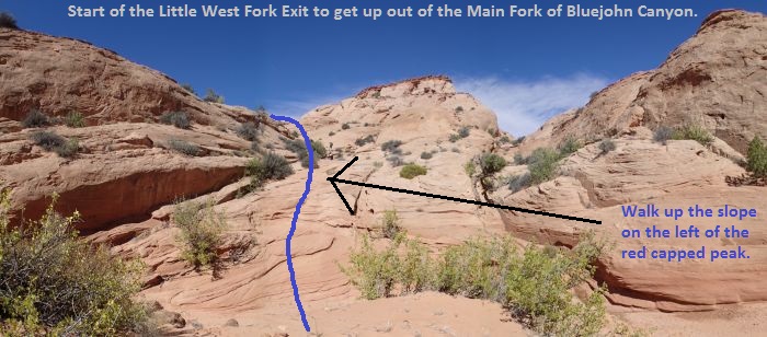 To start up out of the Main Fork of Bluejohn Canyon and use the Little West Fork Exit, start up the slope to the left of the red capped peak.
About 170 feet up out of
the Main Fork of
Bluejohn the slop will
become more gentle
(wBJC-LWF-ExRP01) and
you can see you are
entering a large wide
shallow drainage.
Do not follow up the
drainage forming but
instead turn left to
walk / route find your
way up to the mesa top.
The mesa top is about
400 feet to the west.
To get up there route
find your way up the
slickrock which does get
a little steep in
sections. Just
before reaching the mesa
top there will likely be
a couple spots of light
scrambling.
Once on the mesa top
(wBJC-LWF-ExRP02) it is
about 1.7 miles back to
the parking area where
you started the route
from the junction of the
Hans Flat Road and the
side road leading out to
the sandpipes area.
If you have GPS it may
be useful since travel
is easy in pretty much
any direction which may
get you lost if
careless. If you
have a compass use it to
set a course to the
southwest on a bearing
of 250 degrees true
north (or 238 degrees
magnetic).
About 350 feet farther
and you will be up on a
slightly higher shelf of
the mesa and roughly
following next to a
small canyon on the left
(south). That
small canyon is Turner
Canyon. Continue
southwest across the
desert.
About 0.17 miles farther
is a small hill to go
around
(wBJC-LWF-ExRP03).
The route I have taken
is around the left
(south) side of the hill
but going around the
other side may work just
as well.
About 0.2 miles farther
you will be passing by a
few slickrock dome like
areas (wBJC-LWF-ExRP04).
Shortly after passing
the slickrock domes you
should be able to see an
hill system ahead and
slightly to the left of
your travel bearing.
Extending to the right
(north) of the hill
system us a long ridge
running to the north and
very low to the horizon.
If navigating visually
aim for a spot directly
between the hill system
and the for north end of
the long low ridge.
You still have over a
mile to go. Keep
in mind this area has
very few easy to
identify landmarks.
You will need descent
navigating skills to
stay on course or use
GPS.
Walk the open desert
back to your cars
(extSandPipes).
Note:
If you are a little off
on your bearing you will
still hit a road.
If you hit a road and
you do not see your cars
all you have to do is
determine which way you
need to walk to get back
to them.
Downloadable GPX files
available at
BG-Gear Store
(easier than manual entry and a great way to support
Bluugnome).
Waypoint naming convention and map symbol information can be found on the Glossary page.
Elevations are approximate.
BEFORE
manually entering coordinates set your system to WGS84 datum and Lat/Lon hddd.ddddd° coordinate format.
Inconsistent datum's and coordinate formats will result in location errors.
Click to show / expand the list of waypoints below........
| Bluejohn Little West Fork (1) Drive to Trailhead |
- ExtRobRoost
Lat/Lon (WGS84): N 38.58715
W -110.59263
Elev: 5,120 Feet
Exit for an un-named road used to access the Robbers Roost area.
- wGilsonButeWel
Lat/Lon (WGS84): N 38.58688
W -110.58377
Elev: NaN Feet
Building and small water tank near what is labeled on some maps as Gilso Butte Well.
- extFlintTrail
Lat/Lon (WGS84): N 38.58822
W -110.55632
Elev: NaN Feet
Turn off from an un-named dirt road onto the Lower San Rafeal Road.
- wJefferyWell
Lat/Lon (WGS84): N 38.53010
W -110.54118
Elev: 5,280 Feet
Road turns left here on the drive into Robbers Roost. There are corrals along side the road here.
- wLittleFltTpGt
Lat/Lon (WGS84): N 38.53837
W -110.49108
Elev: 5,520 Feet
A gate the road passes by on the south side of The Little Flat Top.
- extFlintTrail2
Lat/Lon (WGS84): N 38.49947
W -110.41446
Elev: NaN Feet
This is where you can turn left (south) to leave the Flint Trail and drive in towards Chambers.
Or continue straight (east) to continue farther east into the Roost area for other canyons.
- extHansFlat
Lat/Lon (WGS84): N 38.47252
W -110.28042
Elev: 5,521 Feet
Exit off the Lower San Rafeal Road to the Hans Flat Road.
- extSandPipes
Lat/Lon (WGS84): N 38.38046
W -110.30380
Elev: 5,790 Feet
Turn off of the Hans Flat road to go toward the West Fork of Bluejohn and out toward an area also known as Sandpipes. This road leave the Hans Flat road and travels north east.
|
| Bluejohn Little West Fork (2) Approach and Canyon |
- extSandPipes
Lat/Lon (WGS84): N 38.38046
W -110.30380
Elev: 5,790 Feet
Turn off of the Hans Flat road to go toward the West Fork of Bluejohn and out toward an area also known as Sandpipes. This road leave the Hans Flat road and travels north east.
- wBJC-LWF-RP01
Lat/Lon (WGS84): N 38.37700
W -110.29105
Elev: 5,715 Feet
Drop of about 30 feet where a small side drainage is beginning to form in the upper non technical portion of the Little West Fork of Bluejohn Canyon. Bypass the drop by walking around RDC or LDC and walk down to the wash below.
- yBJC-LWF-Tp
Lat/Lon (WGS84): N 38.38154
W -110.28273
Elev: 5,550 Feet
Top entry of the Little West Fork of Bluejohn Canyon (aka Little Bluejohn Canyon). This is where the wide wash drops into a slot. There is a down climb of about 15 feet that may be a little difficult as you slide down a V slot. Optionally this drop can be rigged as a rappel.
- wBJC-LWF-RP02
Lat/Lon (WGS84): N 38.38229
W -110.28199
Elev: NaN Feet
Downclimb of about 15 feet and is a stem style downclimb down through some boulder debris.
- dBJC-LWF-R1
Lat/Lon (WGS84): N 38.38291
W -110.28058
Elev: NaN Feet
Rap 1 - Bluejohn Canyon - Little West Fork. Anchored about 15 feet back from the drop from a large juniper tree and drops about 50 feet down into a deep slot.
Note:
Pulling the ropes from the bottom of the rappel is creating rope grooves at the top from rope drag. To help reduce creation of rope grooves it may be helpful to stand on the boulder at the bottom of the rappel and pull the rope from there. The boulder is about 12 feet high and is an easy downclimb with a partner assist to get down from. Everyone can rappel all the way through while only the last person pulls the ropes from the boulder then downclimbs the 12 feet.
- dBJC-LWF-R2
Lat/Lon (WGS84): N 38.38305
W -110.28008
Elev: NaN Feet
Rap 2 - Bluejohn Canyon - Little West Fork. Anchored from a pinch point between a boulder and the LDC wall and drops about 50 feet.
- yBJC-LWF-Bt
Lat/Lon (WGS84): N 38.38528
W -110.27690
Elev: 5,340 Feet
Bottom of The Little West Fork of Bluejohn Canyon. Some refer to this fork as Little Bluejohn Canyon. Down canyon of this spot is wash walking in kind of wide canyon. Up canyon in the Main Fork of this spot the walls become more narrow creating a scenic narrows..
|
| Bluejohn Little West Fork (3) Exit |
- yBJC-LWF-Bt
Lat/Lon (WGS84): N 38.38528
W -110.27690
Elev: 5,340 Feet
Bottom of The Little West Fork of Bluejohn Canyon. Some refer to this fork as Little Bluejohn Canyon. Down canyon of this spot is wash walking in kind of wide canyon. Up canyon in the Main Fork of this spot the walls become more narrow creating a scenic narrows..
- yTurnerCynBt
Lat/Lon (WGS84): N 38.38784
W -110.27485
Elev: NaN Feet
Bottom of Turner Canyon where it dumps into the Main Fork of Bluejohn Canyon.
- jBJC-LWF-Exit1
Lat/Lon (WGS84): N 38.38891
W -110.27319
Elev: 5,300 Feet
A spot where you can walk up gently sloped sandstone to exit the canyon on the LDC (northwest) side. When looking up the ramp there stay left to go up the slope to the left (west) of the red capped peak.
- wBJC-LWF-ExRP01
Lat/Lon (WGS84): N 38.38930
W -110.27345
Elev: 5,330 Feet
About 170 feet up out of the Main Fork turn left here to head west up the slickrock to gain access to the mesa top.
- wBJC-LWF-ExRP02
Lat/Lon (WGS84): N 38.38879
W -110.27454
Elev: 5,440 Feet
Up on the mesa top where you start the long desert walk back to the vehicles.
- wBJC-LWF-ExRP03
Lat/Lon (WGS84): N 38.38787
W -110.27894
Elev: 5,520 Feet
Small hill to go around. The route I have taken is to the left around the south side of the hill but the other side may work just as well.
- wBJC-LWF-ExRP04
Lat/Lon (WGS84): N 38.38764
W -110.28294
Elev: 5,610 Feet
Passing by some slickrock domes in the desert.
- extSandPipes
Lat/Lon (WGS84): N 38.38046
W -110.30380
Elev: 5,790 Feet
Turn off of the Hans Flat road to go toward the West Fork of Bluejohn and out toward an area also known as Sandpipes. This road leave the Hans Flat road and travels north east.
|