Canyoneering Route Description
Old Bill Canyon - 4B (A) V
Red Rock Canyon, Nevada.
05-08-11, 4 people, 1 Day (Travel time in route 12.8 hours)

08-13-11, 3 people, 1 Day (Travel time in route 12.4 hours)
Time Required - 11.5 to 13.5 hours
Distance - 6.9 miles Total, 1.3 miles Technical
Rappels - 9 Rappels, Longest Rappel 260 feet.
Can make it work with only 220 feet of rope and some
creativity.... see description for rap 4.
Elevation Range - 6548 - 3610 Feet
Shuttle Required -Yes 23.6 Miles Vehicle - High Clearance
(maybe 4WD due to loose gravel)
Permit Required - No
Rappelling and anchor gear, Ropes and or pull cords for rappels up
to 260 feet and 80 feet of 1 inch webbing for sling placement. Wet
suits will be needed in cooler months with water in the canyon.
During hot months with water in the canyon wet suits are optional.
Most if not all of the water is bypass able in the upper section (if
you are careful). The lower section does have a few very short
mandatory swims where a wet suit would be nice but if it is hot out
you might be ok without one. Even in hot months I would suggest
having at least a thin wet suit on hand just in case.
Also of note is that the last
three raps out of the upper
section of Old Bill are south
facing and get a lot of
sunlight. The webbing gets
discolored and degrades quickly
on this wall. Be sure to
bring extra webbing along.
Do not think that someone has
been down it recently and the
webbing will be fine.
Rap 4 is the longest rap at 250 feet. Rap 4 can however be
done with a 220 foot rope, a 250 foot pull line and another rope of
about 50 feet. See the route description for details.
The safest option is to simply have at least one rope of 260 feet or
more for that drop.
Old Bill is another fun route to consider if looking for some
canyoneering fun in the Las Vegas area.
WARNING!!
It is illegal to cross the border between BLM /
Red Rock and the Spring Mountain Ranch State Park. After
exiting Old Bill, do not continue down the wash and into the Spring
Mountain State Park.
The general public is allowed to enjoy the public lands of both the
Spring Mountain State Park and those of the BLM / Red Rock area.
But crossing the border between the two is frowned upon.
After contacting the Nevada State Parks office I was able to get
coordinates for the Spring Mountain Ranch State Park. A couple
scouting hikes and a route was found to exit Old Bill and stay out
of the state park. This exit route is not as easy or straight
forward as traveling through the park but it is legal. The
route description here is for the legal exit route.
Do not cross into the Spring Mountain Ranch State Park.
Rangers actively look for people doing this and may stop you.
The waypoint list below includes the boundary points for the Spring
Mountain State Park in case any one is interested.
Old Bill over all should be given a 3 in technical rating. However
there are some anchor challenges that could complicate things on the
last set of rappels out of the upper section of the canyon. The
anchor challenges motivate me to rate this a 4 in technical
difficulty to err on the side of caution. Also of note is that rap
4 is 260 feet but can be completed with 220 feet of rope and some
extra pull line. Doing rap 4 with 220 feet of rope adds other
safety issues to consider though.
Old Bill is more enjoyable to do when the canyon is full of water.
Obviously the canyon would be rated an A or a B depending on the
amount of water present. Most (not all) of the water in the
canyon is avoidable or you will only be in it a very short time.
With that said I lean toward a water rating of B but note that
subjectively it may be an A.
Also the exit hike can be brutal when hot out.
Thanks to Rick Ianniello for locating this and descending it with
Tom Walmsley before sharing it with the rest of us.
To get to the Trailhead
The junction of highways 159 and 160 are on the out skirts of
town on the south west side of Las Vegas. From the junction of
highway 159 (Charleston Blvd) and highway 160 (Blue Diamond
Road), drive west on highway 160 for 10.2 miles to the turn off
on the right (north) into Mountain Springs (extMountSprngs).
This turn off will be shortly after driving up and over the
crest of Mountain Springs Pass.
Continue west on highway 160 for another 3 miles to the turn off
(extLovellCynRd) for Lovell Canyon Road on the right (north).
Turn right (north) onto the dirt road here.
After turning onto Lovell Canyon Road (extLovellCynRd), drive 1
mile north to a turn off for a dirt road going right (north
east). This turn off (extRainbwSpngs) follows a wash up
toward Rainbow Springs.
Drive up the road about 1.7 miles to a sign that say Entering
Red Rock Canyon. Continue north east another 1.2 miles to
where the road starts to travel into a much more narrow section
of the wash and get rougher and have more soft gravel to get
stuck in (pk-Old-Bill-Tp). This is a good spot to park.
You can drive farther up the road if you like but you chance
getting stuck. You can only drive a couple hundred feet
farther anyway.
To leave the Exit Vehicle / Escape Pod
From the junction of highway 215 and Charleston Blvd (highway
159), drive west on Charleston Blvd (highway 159) about 11.1
miles to the trailhead for First Creek (tFirstCreekTH). The
First Creek trailhead will be on the right.
OR
From the junction of the Blue Diamond highway (highway 160) and
highway 159, drive 6.3 miles north west on highway 159 to the
trailhead for First Creek (tFirstCreekTH). The First Creek
trailhead will be on the left.
The First Creek trailhead is where you will leave your exit
vehicle. This is a large dirt pull out with a wood and
wire fence marked as the First Creek Trailhead.
GPS coordinate information listed at the bottom. For information about waypoint naming and map symbols, refer to the
Glossary page.

Click the links for maps of the route.
Map of the entire route.
Map of the approach.
Map of the technical section.
Map of the
first part of exit skirting boundary.
The Approach:
From the parking spot (pk-Old-Bill-Tp) travel north east up the wash
passing a sign about the Rainbow Wilderness fire in 2006 shortly
after leaving the parking spot.
A little over 0.2 miles from the parking area, the route leaves
(wOldBill-RP-01) the wash to the right (east) and follows up an old
dirt road. This road is very close to the actual Rainbow
Spring.
About 375 feet farther will be a fork in the road (wOldBill-RP-02).
For navigation it is better to stay left at the fork.
The fork is two roads that go around and Agave Pit and rejoin about
350 feet farther up. If you follow the fork to the right, it
is likely you will pass the point where you leave the road and not
even know you have passed it.
Follow the left fork until you see where the two roads rejoin.
Just before the two roads rejoin there will be a large turn out parking area
(wOldBill-RP-03) on the left side of the road where it makes a
turn. This large turn out is where the route leaves the road
and starts following a well used use trail.
Note:
The road here curves around and continues south while the trail
leaves the turn out and starts north. The trail is on the north
west side of the turn out and is not very easy to spot.
As you leave the turn out and start through the dirt, contour around
to the north. About 200 or 300 feet from the turn out
you will be able to spot the trail ahead of you where it begins to
get very well defined and easy to follow.
About 275 feet from the road the trail crosses over a small
drainage.
Another 500 feet farther the trail curves around a larger drainage
(wOldBill-RP-04) with patches of gray limestone just before reaching
it. The trail is well defined and easy to follow and crosses
over a few more drainages as it continues generally north.
About another 0.5 miles the trail curves right a little
(wOldBill-RP-05) and starts to travel more north east and will now
parallel a drainage to the right (south) of the trail.
About 0.2 miles farther the trail is still paralleling the wash but
tops out briefly (wOldBill-RP-06) before dropping back down to the
wash about 200 feet farther.
Follow north east up the wash about 600 feet to where the trail
starts up out of the wash (wOldBill-RP-07) again on the right (east)
side of the wash. The trail goes up out of the wash north east
roughly paralleling the wash on the right before veering right to
get up onto the ridge.
After about 350 feet, the trail turns right (wOldBill-RP-08) and
starts to climb up to get up to the ridge line.
The trail goes up with some switch back along the way for about 0.3
miles to where it crosses over the top of a shelf or pour off in a
drainage (wOldBill-RP-09). As the trail crosses over the shelf
it curves right and begins to travel south.
About 475 feet after crossing the shelf in the wash, the trail will
come to a saddle (wOldBill-RP-10). There are great views east
down over part of Sandstone canyon. To continue toward
Old Bill Canyon, travel left (north) up the ridge line. The
trail fades away to nothing so you will need to route find your way
up the ridge.
About 400 feet up the ridge the trail becomes very well defined
again (wOldBill-RP-11). The trail here is slightly left (west)
of the crest of the ridge line.
About 0.2 miles farther is another saddle (wOldBill-RP-12).
This saddle has good views to the southeast over another fork of
Sandstone Canyon. Just after this saddle the trail becomes
faint and hard to follow for a short distance.
From this saddle the trail slowly curves right (east) for about 500
feet to get up onto the ridge crest (wOldBill-RP-13). From
this part of the ridge is where you get the first views north east
down into the canyon system with Old Bill. You also have views south
east down into more of Sandstone Canyon. This spot feels like
a small saddle but is more of a slightly level spot on the ridge.
Note:
From this saddle you could scramble and slide down the slope here
into the main canyon. Once down in the bottom of the main
canyon it is a boulder hopping route down the wash. The route
down this slope then down the wash in the main canyon, would be
about 0.6 miles to where it gets to the last rappel out of the upper
part of Old Bill. Since the upper part of Old Bill (in the
side slot on the north side of the main canyon) is the more
difficult portion, following down the slope to the main canyon from
this point would make this an easier route and well suited for
beginners. But you miss out on a lot of the cool portions of
the route by doing this.
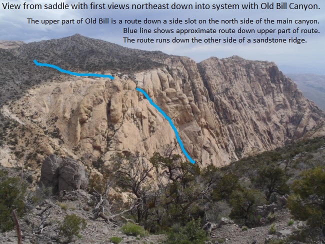
View from the saddle down into the main canyon with the Old Bill Route. The blue line represents
the route down a side slot on the north side of the canyon which is the upper portion of the Old Bill route.
Continue north up the ridge line to get to a cliffy limestone peak.
The trail up to the peak on the ridge line is almost non existent so
you will need to route find your way up. The top of the cliffy
peak (wOldBill-RP-14) is about v900 feet way. This peak offers
an awesome view down into the main canyon.
From the peak (wOldBill-RP-14), continue north and route find your
way along the ridge down the other side of the peak. About 500 feet
from the top of the peak the ridge line will flatten out a little
and be easier to follow where you can signs of foot traffic but not
a trail. About 0.3 miles after leaving the top of the peak
will be a long wide saddle (wOldBill-RP-15).
Continue north east up the ridge for about 0.2 miles to where the
trail kind of tops out (wOldBill-RP-16). This is where you
will leave the main ridge line and start the descent down toward Old
Bill.
Navigation Note:
To visually assist with knowing you are on the right spot........
From the saddle you were on about 0.2 miles you could still see
Bonnie Springs. From this high point on the ridge you can no
longer see Bonnie Springs but you can see the small town of Blue
Diamond in the distance.
Leave the main ridge you have been following to the north and start
down a side ridge to the right (south east). From the top of
this side ridge (wOldBill-RP-16) route find your way down the ridge
about 0.25 miles to where the ridge turns from gray desert dirt and
meets the white sandstone layer (wOldBill-RP-17).
When you get to the sandstone layer drop off the ridge and get down
into the drainage on the left (north) about 270 feet away.
Once down in the drainage you will be near the top of the sandstone
layer and at the top entry for Old Bill (yOldBill-Tp).
The Canyoneering / Technical Section:
Once in the sandstone drainage at the top of Old Bill (yOldBill-Tp),
walk down canyon about 200 feet to the top of a drop of about 40
feet (wOldBill-RP-18). This drop can be bypassed either RDC or
LDC. Another larger drop is right after this one and is also
about 40 feet. The second drop is bypassed by scrambling
around LDC.
After the two drops continue south east down the canyon in a fairly
level wash for about 300 feet to a few minor drops to down climb of
4 to 8 feet each. As you continue down the series of short
down climbs you will also get to a few small potholes to stem over
where the canyon starts to narrow up considerably. If the
canyon is full of water you may have to wade up to waist deep in a
couple spots. Shortly after the potholes will be rap 1.
Rap
1 (dOldBill-R1) is a little more than 700 feet down canyon of the head, is anchored from
a small pine tree on the RDC side about 5 feet back from the drop and drops about
20 feet down a vertical wall in a narrow section to a pool that is
avoidable in high or low water conditions..
Down canyon of rap 1 are 5 drops of about 15 to 20 feet each down to
potholes. All of the drops are stem or chimney down climbs and all
of the pools can be climbed over even if the canyon is full of water.
If you do slip into the pools they are all about waist deep except for
the second pool after rap 1 which will be a swimmer but only for a
couple feet. Just after the 5th drop is the top of rap 2 where the
canyon takes a sharp left.
Rap 2 (dOldBill-R2) is about 150 feet down canyon of Rap 1, is anchored from
a large choke stone at the top of the drop and drops about 25 feet down a
narrow slot. The first half of rap 2 is down climbable but the
last portion has an over hang making this a rappel.
At the bottom of rap 2 is a small gravel filled pothole that will be
between calf and waist deep depending on how much gravel is in it at the
time.
Down canyon of rap 2 the canyon takes a sharp right and continues
through a narrow winding section over a few small pothole pools that are
easily climbed over. The potholes are deep and would be swimmers
but each of them is fairly easy to climb over.
Soon you will come to a drop of about 15 feet that winds down to a
pothole on with a drop on the other side of the pothole. It is
possible to skirt around the pothole to get to the ledge on the other
side without having to drop into the water. The drop down from
this ledge is about 15 feet down to another pothole where the
narrow slot widens out a little. This drop looks like a difficult
down climb and feels like a rappel. The down climb is tricky but
not as hard as it looks. Down climb by sliding down about 6 feet
to a crack on the left that. The crack provides hand holds to
lower your self down to a small ledge below. Using both hands to
do a hand match here makes this an easy lower. After lowering
yourself down to the small ledge traverse LDC to an easy scramble around
to the canyon floor (wOldBill-RP-19).
For safety, one of the better down climbers in the group could provide a top belay then down climb last. Those at the bottom can provide assistance from the bottom if needed.
Note:
If this drop is set up as a rappel, an anchor option would be to use a
rock of about grapefruit size in a crack LDC of the drop. The
anchor rock would need to be farmed from below if this is done.
Next the canyon begins to open up a little and travel down sloped
rolling sandstone over a few easy scrambles. There will also be
one scrambling down climb of about 15 feet down into a pool that could
be about waist deep if full. As you travel through this section
you can tell you are getting closer to the main canyon that Old Bill
drops into.
About 200 feet down canyon of the tricky ledge and pothole down climb,
you will come up to a large boulder in the wash (wOldBill-RP-20).
There will be a down climb on the RDC (west) side of the boulder of
about 20 feet. The start of this down climb is a little awkward
due to an under cut under the boulder.
For safety, one of the better down climbers in the group could provide a top belay then down climb last. Those at the bottom can provide assistance from the bottom if needed.
Note:
If this drop is rigged as a rappel there are many rocks at the top of
the drop that can be used.
After getting down this down climb it becomes very obvious that the begins to
get a lot steeper and start the descent down toward the main canyon
below. You also begin to get views over toward Bonnie Springs to
the south east. If you look close you can see the cell tower and
water tanks just behind Bonnie Springs.
Just before reaching rap 3 will be two more down climbs of 20 to 25 feet
each. Both are easily down climbed along cracks on the RDC side.
Rap 3 (dOldBill-R3) is about 400 feet down canyon of
rap 2, is anchored from a pinch point between the RDC wall and a boulder and drops about
150 feet down a slightly sloped wall with a pothole ledge about a third
of the way down. Rap 3 is the first of 3 raps that quickly drop
down to the main canyon below.
Rap 3 drops down to a ledge with a large pothole on it which is easily
avoidable. From the ledge at the bottom of rap 3 a sliver of
Bonnie Springs can be seen in the distance.
Note:
At the bottom of rap 3 and top of rap 4 is a chute or ravine on
the LDC (east) side. This ravine may provide other anchor options
but would be difficult and sketchy to get up to it.
Safety Note:
To get to the anchor for rap 4 you will need to scramble up a
crack to the anchor. This is not a difficult scramble but the
consequences of a bad fall could prove fatal if you rolled off of rap 4.
A safer option would be to stay on rope while on rap 3 and tie off while
you inspect and rig the anchor for rap 4.
If for some reason the anchor for rap 4 is missing or not acceptable
another option would be a pot shot anchor in the pot hole. There
is very little debris in the pothole so this may not be an easy option
to use.
Rap 4 (dOldBill-R4) is right at the bottom of rap 3
on a ledge by a pothole. Rap 4 is anchored RDC from a choke
stone placed in a crack about 15 feet above the ledge and drops about
260 feet down a mostly vertical wall with.
Note:
Rap 4 drops about 250 feet. However rap 4 can be
completed with a 220 foot rope, a 260 feet pull line and some
creativity. About 220 feet down rap 4 is a ledge where you can get
off rappel. From this ledge you can scramble down the last 30 feet
on the RDC side. The last few feet of this scramble are steep
making it a little sketchy. CAUTION, if you rolled off of the steep part
at the bottom of the ledge you would risk falling over rap 5. The
first person down can easily offer a thigh belay to the rest of the
party at the bottom of the ledge scramble.
You will need 250 feet on the pull side of the rappel even if doing the
220 foot option. Pulling from the ledge would be difficult and
possibly un-safe. A better and safer pull can be done from the
bottom of the rappel.
Possible suggestion for 220 foot rope:
The first person down can rap down to the ledge with an extra rope.
Once on the ledge they can stand there and tie the extra rope to the rap
rope then get back on rappel below the knot. Each person after
that can stand on the ledge to pass the knot as well. The last
person down can stop at the ledge and untie the ropes dropping the
bottom rope to those below. The last person can them scramble down
the ledge and get some assistance on the last part from someone at the
bottom. The rope is then pulled from the bottom of the rappel.
At the bottom of rap 4 is a large wide flat ledge where rap 5 starts.
Rap 5 (dOldBill-R5) is on the ledge at the bottom of rap 4, is anchored from
a knot chalk in a crack on the LDC side of the ledge and drops about 230 feet down a
sloped wall with ledges. The anchor for rap 5 is a knot chalk in a crack
between a boulder and the canyon wall. The webbing is redirected
down through the crack then pulled over toward the top of the rap.
There is also enough rock debris on the ledge to build a cairn style
anchor.
Note:
Rap 5 is on an overall gentle angle with ledges. All but the first
50 feet could be scrambled down but the overall length of this makes
rappelling a safer option. You will need to rap down the first 50
feet but anything past that is just a safety on a long scramble.
At the bottom of rap 5 continue scrambling a little more to get down to
the floor of the main canyon (jOldBill-Upper). Once you are in the
main canyon travel down canyon with a mix of some bush whacking and
boulder hopping.
About 250 feet down canyon will be a drop of about 50 feet in a narrow
section (wOldBill-RP-21). Bypass RDC by walking along a ledge then
scrambling down to the canyon floor. Down canyon of this drop are
multiple pools to skirt around and down easy down climbs to play on for
about 0.2 miles to rap 6. This portion of the canyon is where you
start to see more and more running water (depending on time of year and
recent rains).
Rap 6 (dOldBill-R6-7) is about 0.3 miles down canyon of where you
dropped down into the main canyon, is anchored from a large boulder at
the top of the drop and drops about 35 feet down over two stages. The
first stage drops down to a place to stand among the boulders where
there is a small hole at your feet. Down climb and lower yourself
through the hole to drop down the second stage under more boulders.
You will likely have to take your pack off to fit through the hole.
Larger people will have to drop over the down canyon side of stage two
if they don't fit through the hole. Depending on what recent
floods have done to the canyon, the rabbit hole may or may not be filled
in.
Rap 7 is about 70 feet down canyon of rap 6, is anchored from a pinch
point between a boulder and the canyon wall and drops about 60 feet down
a narrow section to a pool that will be a swimmer. You will need to do
a swimming disconnect then swim for about 20 feet to the other end of
the pool.
On the other side of the pool after rap 7 the canyon takes a sharp right
in a narrow section then veers left as the slot opens up to some
boulders to down climb. Continue down canyon skirting around pools
and down climbing over boulders. Rap 8 will be about 0.35 miles
down canyon of rap 7.
Rap 8 (dOldBill-R8) is about 0.35 miles down canyon of rap 7, is anchored
RDC from a pinch point between boulders and drops about 30 feet down a
sloped wall. Optionally rap 8 can be bypassed on the RDC side by
down climbing over on sloped slick rock.
Rap 9 (dOldBill-R9) is almost 400 feet down canyon of rap 8 and is anchored from
a large rock in a shallow pothole about 15 feet back from the drop and drops about
30 feet down a sloped wall to a shallow pool. Rap 9 looks like it
may be possible to bypass RDC but also looks like that might be a little
sketchy. When the canyon flashes and the anchor rock disappears, a
knot chalk can be set up in a crack about 20 feet back from the rap on
the RDC side.
After rap 9 continue down canyon boulder hoping and down climbing
sections of slick rock and skirting around pools. About 450 feet
down canyon of rap 9 will be a short down climb where you have an option
of squeezing down through a tight rabbit hole between some boulders
(wOldBill-RP-22). If you don't feel comfortable with squeezing in
the hole you can down climb over the boulders then slide down slick rock
on the LDC side. This down climb drops to another pool.
About 250 feet farther down canyon will be a drop of about 30 feet
(wOldBill-RP-23). The drop starts on the LDC side of the canyon
between a boulder and the canyon wall. This is a tricky down climb
that pretty much requires a hand line tied to a choke stone. As
you start down the down climb you will quickly drop and swing while
hanging onto the hand line. Once you are hanging from the loop ion
the hand line you can let go and slide down some sloped rock to a
boulder. The rest of the down climb is easy from there.
People with little upper body strength will not like this one.
For safety, one of the better down climbers in the group could provide a top belay then down climb last. Those at the bottom can provide assistance from the bottom if needed.
About 0.25 miles farther the canyon veers right where a side drainage
joins in from LDC. This is where the canyon starts to widen out
and turn into a wide pretty level wash with boulders all over.
This is the end of the Old Bill Canyon (yOldBill-Bt).
The Exit:
Note:
As you exit the narrow canyon and into the wider wash with a lot of
huge boulders to scramble over you will not be continuing down the
wash to make the exit route. Staying in the wash here will
force you to cross the border from BLM land and into the Spring
Mountain Ranch State Park land. Crossing this border is
illegal so another route is used.
Before starting down over the boulders, take a look at the LDC side
of the wash. Note the dirt and rock slope about 600 feet away
that runs down from the white cliff band above down toward the wash
you are in. Route find your way up out of the canyon on the
LDC (north) side and
traverse east toward the lower end of the dirt and rock slope.
Traversing up out of the canyon toward the dirt slope the route is
working its way up onto the top of a reddish cliff band above the
wash you were in. This portion of the exit route follows along
the shelf at the top of this reddish cliff band.
About 350 feet after leaving the wash will be a reddish slick rock
pour off to cross over (wOldBill-RP-24).
After crossing the pour off continue traversing continue east
traversing the dirt / rock slope near the lower end of it.
About 200 feet after crossing the pour off will be an obvious large
flat rock area (wOldBill-RP-25). This is where it becomes more
obvious you will be following a shelf along the top of a reddish
cliff band to your right and the tall white / yellow cliff band at
the top of the slope to your left. The shelf you are walking
on becomes more red. Route find your way along the shelf
contouring around to the north east.
About 0.2 miles farther will be a small but obvious rock debris
field (wOldBill-RP-26) running down the red slope. Cross over
this debris pile and continue north east on the reddish shelf.
A little over 200 feet after this rock debris field is where the
route gets within a few feet of the Spring Mountain Ranch State Park
boundary. As you continue along the shelf from here try to
stay high and stay close to the red out croppings along the shelf.
This will be about 50 or 60 feet higher than what feels like the
natural route.
About 280 feet after (wOldBill-RP-27) crossing the small white /
yellow debris field you will get a view of another white / yellow
debris field that is much larger and has much larger rocks in it
about 100 feet away. When you see this larger debris field
note there is an area of the debris field that has most of the large
rocks. Crossing this rock debris field near the upper end of
the large rock region will keep you from crossing into the park
boundary. This is the fine print part of the route that if
followed will keep you out of the Spring Mountain Ranch State Park.
Following what feels like a natural route will lead you across a
small corner of the boundaries putting you in the park for about 100
feet. Staying high on the red rock leading to the larger
debris field will keep you only a few feet outside the park.
After crossing the larger debris field (wOldBill-RP-28) the shelf
widens out a little. Stay lower on the shelf walking along the
top of the cliff below.
A little over 500 feet after crossing the larger debris field will
be the top of (wOldBill-RP-29) a ridge on the right (east) running
down from the shelf you are on down to the desert floor. You
could drop down this obviously easy ridge down to the desert below.
But doing may complicate the route a little if you intend to stay
out of the park boundaries.
Continue north along the shelf about 250 feet and look for the top
of a chute (wOldBill-RP-30) to scramble down to get to the top of
another ridge running east down to the desert below. This
chute IS NOT OBVIOUS and is sometimes marked with cairns. Keep
an eye open for some carins that might clue you in on this chute.
Note:
If you go too far you will soon get to a drainage to scramble across
(wOldBill-RP-XX). From this drainage you will have a good view
down and north toward a dark red and smooth ridge running down to
the desert floor. If you get here turn around and go back
south about 100 feet to look for the chute you missed.
Scramble down the chute about 30 feet to get to a ridge running east
down to the desert floor. Then continue down the ridge toward
the desert floor. As you get near the bottom of the ridge look
left (northish) for a very large obvious red rock out cropping about
250 feet away and make your way over to it.
From the large red rock out cropping (wOldBill-RP-31), route find
your way north about 0.7 miles to intersect with the First Creek
trail (wOldBill-RP-32). Where you meet the First Creek trail
will vary depending on your route through the desert floor.
This 0.7 miles is a little annoying as there are no trials and the
terrain is rolling and rock filled. Resist the urge to veer
east and head toward the cars. Doing this will lead you into
the park boundary AND prolong the difficult travel with no trails.
When you make it to the First Creek trail you will be greeted with
wide open almost street like trail to walk back to the car.
When you reach the First Creek Trail (wOldBill-RP-32) turn right and
walk the wide trail about 0.9 miles to the exit vehicle (tFirstCreekTH).
Downloadable GPX files
available at
BG-Gear Store
(easier than manual entry and a great way to support
Bluugnome).
Waypoint naming convention and map symbol information can be found on the Glossary page.
Elevations are approximate.
BEFORE
manually entering coordinates set your system to WGS84 datum and Lat/Lon hddd.ddddd° coordinate format.
Inconsistent datum's and coordinate formats will result in location errors.
Click to show / expand the list of waypoints below........
| Old Bill (1) - Drop Exit Vehicle |
- tFirstCreekTH
Lat/Lon (WGS84): N 36.08138
W -115.44797
Elev: 3,650 Feet
First creekTrail Head on Charleston.
|
| Old Bill (2) - Drive to Trailhead |
- extLovellCynRd
Lat/Lon (WGS84): N 36.01843
W -115.56133
Elev: NaN Feet
Turn off from highway 160 to Lovell Canyon road.
- extRainbwSpngs
Lat/Lon (WGS84): N 36.03130
W -115.55539
Elev: NaN Feet
Turn off from the Lovell Canyon Road onto the Rainbow Springs Raod.
- pk-Old-Bill-Tp
Lat/Lon (WGS84): N 36.05037
W -115.51231
Elev: 5,520 Feet
This is where to park for starting the route to Old Bill Canyon. This is a point on the Rainbow Springs road where the wash begins to get a lot more narrow and the road rougher.
|
| Old Bill (3) - Approach |
- pk-Old-Bill-Tp
Lat/Lon (WGS84): N 36.05037
W -115.51231
Elev: 5,520 Feet
This is where to park for starting the route to Old Bill Canyon. This is a point on the Rainbow Springs road where the wash begins to get a lot more narrow and the road rougher.
- wOldBill-RP-01
Lat/Lon (WGS84): N 36.05200
W -115.51079
Elev: NaN Feet
Turn and walk right (east) up the road out of the wash on an old dirt road.
- wOldBill-RP-02
Lat/Lon (WGS84): N 36.05230
W -115.50961
Elev: NaN Feet
Fork in the road. Take either the right or left. They rejoin about 350 feet farther.
- wOldBill-RP-03
Lat/Lon (WGS84): N 36.05235
W -115.50861
Elev: 5,620 Feet
Large turn out on the north side of the road where the road makes a tight bend. This is where you will leave the road to follow a trail.
- wOldBill-RP-04
Lat/Lon (WGS84): N 36.05411
W -115.50764
Elev: NaN Feet
Trail curves around a drainge with some gray limestone on the route just before reaching it.
- wOldBill-RP-05
Lat/Lon (WGS84): N 36.05896
W -115.50401
Elev: 5,810 Feet
Trail begins to curve right and start to travel more north east. Also the trail will parallel a drainge on the right (south).
- wOldBill-RP-06
Lat/Lon (WGS84): N 36.05918
W -115.50049
Elev: NaN Feet
Trail still paralleling the wash but tops out briefly here before dropping back down into the wash.
- wOldBill-RP-07
Lat/Lon (WGS84): N 36.06038
W -115.49877
Elev: 5,955 Feet
Trail starts up out the wash on the right (east) and starts up to the ridge. The trail parallels the wash for a short distance after leaving the wash.
- wOldBill-RP-08
Lat/Lon (WGS84): N 36.06123
W -115.49822
Elev: NaN Feet
Trail stops paralleling the wash and veers right (east) to start up to teh ridge line.
- wOldBill-RP-09
Lat/Lon (WGS84): N 36.06244
W -115.49585
Elev: 6,120 Feet
Trail crosses over the top of a shelf or pour off in a draiange.
- wOldBill-RP-10
Lat/Lon (WGS84): N 36.06148
W -115.49517
Elev: 6,085 Feet
Trail gets to a saddle with great views down into Sandstone Canyon to the east. To follow the route toward Old Bill Canyon, route find your way along the ridge line to the north.
- wOldBill-RP-11
Lat/Lon (WGS84): N 36.06253
W -115.49525
Elev: NaN Feet
Trail up the ridge becomes well defined again.
- wOldBill-RP-12
Lat/Lon (WGS84): N 36.06528
W -115.49562
Elev: 6,275 Feet
Trail comes to another saddle. Views south east down to another fork of Sandstone Canyon. The trail continues north along teh ridge line but fades away and is hard to follow for a short distance.
- wOldBill-RP-13
Lat/Lon (WGS84): N 36.06631
W -115.49498
Elev: 6,325 Feet
Trail is up on part of the ridge crest where you start to get your first views north east down into the canyon system with Old Bill. You also have views south east down into more of Sandstone Canyon.
- wOldBill-RP-14
Lat/Lon (WGS84): N 36.06781
W -115.49700
Elev: 6,548 Feet
Top of a cliffy limestone peak along teh ridge line. THis peak overlooks the canyon system with Old Bill in it.
- wOldBill-RP-15
Lat/Lon (WGS84): N 36.07114
W -115.49559
Elev: 6,370 Feet
Long saddle along the ridge after crossing over the cliffy limestone peak.
- wOldBill-RP-16
Lat/Lon (WGS84): N 36.07341
W -115.49370
Elev: 6,540 Feet
Ridge line tops out briefly and is where you start the descent down towards Old Bill.
- wOldBill-RP-17
Lat/Lon (WGS84): N 36.07222
W -115.49081
Elev: NaN Feet
The desert dert of the ridge line above meets the sandstone layer below at this point. Find a way down from the ridge into the draiange on the left (north)
- yOldBill-Tp
Lat/Lon (WGS84): N 36.07211
W -115.48998
Elev: 6,190 Feet
Top entry for Old Bill. This is near the top of the sandstone portion of this draiange.
|
| Old Bill (4) - The Canyon, |
- yOldBill-Tp
Lat/Lon (WGS84): N 36.07211
W -115.48998
Elev: 6,190 Feet
Top entry for Old Bill. This is near the top of the sandstone portion of this draiange.
- wOldBill-RP-18
Lat/Lon (WGS84): N 36.07157
W -115.48999
Elev: NaN Feet
The first of two drops next to each other. Both drops are bypassed by scrambling around them.
- dOldBill-R1
Lat/Lon (WGS84): N 36.07074
W -115.48836
Elev: NaN Feet
Rap 1 - Old Bill Canyon. Anchored from a small pine tree and drops about 20 feet down a vertical wall in a narrow slot.
- dOldBill-R2
Lat/Lon (WGS84): N 36.07075
W -115.48789
Elev: NaN Feet
Rap 2 - Old Bill CAnyon. Anchored from a choke stone and drops about 25 feet in a narrow slot. The first half is down climbale but the lower half has an overhang.
- wOldBill-RP-19
Lat/Lon (WGS84): N 36.07056
W -115.48766
Elev: NaN Feet
Down climb from a ledge and pothole that looks tricky but is made easy by lowering yourself from a crack.
- wOldBill-RP-20
Lat/Lon (WGS84): N 36.07002
W -115.48736
Elev: NaN Feet
Large boulder in the wash with a down climb along the RDC (west) side.
- dOldBill-R3
Lat/Lon (WGS84): N 36.06983
W -115.48714
Elev: NaN Feet
Rap 3 - Old Bill Canyon. Anchored from a pinch point between a boulder and the canyon wall and drops about 150 feet down a slightly sloped wall with a pothole ledge about one third of the way down.
- dOldBill-R4
Lat/Lon (WGS84): N 36.06949
W -115.48709
Elev: NaN Feet
Rap 4 - Old Bill Canyon. Right at the bottom of rap 3. Anchored from a choke stone in a crack about 15 feet up from the ledge on the RDC side and drops about 250 feet but can creatively be done with 220 feet.
- dOldBill-R5
Lat/Lon (WGS84): N 36.06921
W -115.48699
Elev: NaN Feet
Rap 5 - Old Bill Canyon. Anchored from a knot chalck LDC on the learge ledge at the bottom of rap 4. Rap 5 drops about 230 feet but only the first 50 feet are mandatory.
- jOldBill-Upper
Lat/Lon (WGS84): N 36.06869
W -115.48665
Elev: 5,205 Feet
This is where the upper portion of the Old Bill route dumps into the main canyon.
- wOldBill-RP-21
Lat/Lon (WGS84): N 36.06879
W -115.48571
Elev: NaN Feet
Drop of about 50 feet that is bypassed RDC by walking a ledge then scrambling down to the floor of the canyon.
- dOldBill-R6-7
Lat/Lon (WGS84): N 36.06857
W -115.48255
Elev: NaN Feet
Raps 6 thru 7 - Old Bill Canyon.
Rap 6 anchored from a boulder at the top of the drop and drops about 35 over two stages through a boulder pile. Down climb and lower into a hole at your feet to start the second stage.
Rap 7 about 70 feet down canyon of rap 6, is anchored from a pinch point between the wall and a boulder. Rap 7 drops about 60 feet down a narrow slot to a pool that needs to be swam at the bottom.
- dOldBill-R8
Lat/Lon (WGS84): N 36.06641
W -115.47875
Elev: NaN Feet
Rap 8 - Old Bill Canyon. Anchored from a pinch point between boulders and drops about 30 feet down a sloped wall. Rap 8 can be bypassed RDC.
- dOldBill-R9
Lat/Lon (WGS84): N 36.06563
W -115.47797
Elev: NaN Feet
Rap 9 - Old Bill Canyon. Anchored from rock in small pothole about 15 feet back and drops about 30 feet down a sloped wall to a shallow pool.
- wOldBill-RP-22
Lat/Lon (WGS84): N 36.06477
W -115.47726
Elev: NaN Feet
Short down climb to a pool. This drop gives the option to squeeze through a small rabbit hole between boulders to shorten the down climb.
- wOldBill-RP-23
Lat/Lon (WGS84): N 36.06486
W -115.47649
Elev: NaN Feet
Drop of about 30 feet with a hand line that is used to drop and swing under a boulder. Then let go of the hand line to slide down some sloped rock.
- yOldBill-Bt
Lat/Lon (WGS84): N 36.06539
W -115.47330
Elev: 4,065 Feet
Bottom exit of Old Bill Canyon where it opens up into a pretty wide wash.
|
| Old Bill (5) - Exit |
- yOldBill-Bt
Lat/Lon (WGS84): N 36.06539
W -115.47330
Elev: 4,065 Feet
Bottom exit of Old Bill Canyon where it opens up into a pretty wide wash.
- wOldBill-RP-24
Lat/Lon (WGS84): N 36.06539
W -115.47196
Elev: 4,108 Feet
Reddish slick rock pour off to cross over.
- wOldBill-RP-25
Lat/Lon (WGS84): N 36.06544
W -115.47126
Elev: 4,130 Feet
Large flate red rock area on the ledge of the cliff band.
- wOldBill-RP-26
Lat/Lon (WGS84): N 36.06700
W -115.46942
Elev: 4,282 Feet
Small but obvious yellow / white rock debris pile running down the red slope.
- wOldBill-RP-27
Lat/Lon (WGS84): N 36.06776
W -115.46917
Elev: 4,390 Feet
This is a point about 280 feet after crossing the smaller debris field behind you where you now get a view of a larger debris filed about 100 feet ahead (north).
- wOldBill-RP-28
Lat/Lon (WGS84): N 36.06805
W -115.46901
Elev: 4,400 Feet
Crossing a larger white / yellow rock debris field.
- wOldBill-RP-29
Lat/Lon (WGS84): N 36.06921
W -115.46809
Elev: 4,405 Feet
Top of a ridge running down from the shelf to the desert below. This can be used to get down from the shelf but complicates the route with the state park boundaries.
- wOldBill-RP-30
Lat/Lon (WGS84): N 36.06994
W -115.46802
Elev: 4,390 Feet
Top of a chute to scramble down to get to a ridge running east down to the desert below.
- wOldBill-RP-XX
Lat/Lon (WGS84): N 36.07021
W -115.46831
Elev: 4,435 Feet
A draiange to scramble across if you went too far and past the chute you need to get down off the shelf. From this drainage you have a view over to a very dark red smooth dirt ridge. If you get here turn around and go back south about 100 feet to look for a chute dropping off the shelf.
- wOldBill-RP-31
Lat/Lon (WGS84): N 36.07071
W -115.46639
Elev: 4,080 Feet
Large obvious red rock out cropping in the desert.
- wOldBill-RP-32
Lat/Lon (WGS84): N 36.08013
W -115.46444
Elev: 3,840 Feet
Very Approximate spot the exit route from Old Bill might meet the First Creek trail. Where the route meets the trail will depend on the aimless wondering across the desert to the trail.
- tFirstCreekTH
Lat/Lon (WGS84): N 36.08138
W -115.44797
Elev: 3,650 Feet
First creekTrail Head on Charleston.
|
| SpngMntRnchSP-Boundary |
- SMRSP-Bndry-01
Lat/Lon (WGS84): N 36.06479
W -115.47315
Elev: 0 Feet
Boundary point for Spring Mountain Ranch State Park. Obtained from the Nevada State Park Program Manager.
- SMRSP-Bndry-02
Lat/Lon (WGS84): N 36.06464
W -115.46896
Elev: 0 Feet
Boundary point for Spring Mountain Ranch State Park. Obtained from the Nevada State Park Program Manager.
- SMRSP-Bndry-03
Lat/Lon (WGS84): N 36.06788
W -115.46911
Elev: 0 Feet
Boundary point for Spring Mountain Ranch State Park. Obtained from the Nevada State Park Program Manager.
- SMRSP-Bndry-04
Lat/Lon (WGS84): N 36.06778
W -115.46480
Elev: 0 Feet
Boundary point for Spring Mountain Ranch State Park. Obtained from the Nevada State Park Program Manager.
- SMRSP-Bndry-05
Lat/Lon (WGS84): N 36.07132
W -115.46473
Elev: 0 Feet
Boundary point for Spring Mountain Ranch State Park. Obtained from the Nevada State Park Program Manager.
- SMRSP-Bndry-06
Lat/Lon (WGS84): N 36.07129
W -115.46034
Elev: 0 Feet
Boundary point for Spring Mountain Ranch State Park. Obtained from the Nevada State Park Program Manager.
- SMRSP-Bndry-07
Lat/Lon (WGS84): N 36.07521
W -115.46040
Elev: 0 Feet
Boundary point for Spring Mountain Ranch State Park. Obtained from the Nevada State Park Program Manager.
- SMRSP-Bndry-08
Lat/Lon (WGS84): N 36.07512
W -115.45629
Elev: 0 Feet
Boundary point for Spring Mountain Ranch State Park. Obtained from the Nevada State Park Program Manager.
- SMRSP-Bndry-09
Lat/Lon (WGS84): N 36.07882
W -115.45639
Elev: 0 Feet
Boundary point for Spring Mountain Ranch State Park. Obtained from the Nevada State Park Program Manager.
- SMRSP-Bndry-10
Lat/Lon (WGS84): N 36.07866
W -115.44682
Elev: 0 Feet
Boundary point for Spring Mountain Ranch State Park. Obtained from the Nevada State Park Program Manager.
- SMRSP-Bndry-11
Lat/Lon (WGS84): N 36.07132
W -115.44673
Elev: 0 Feet
Boundary point for Spring Mountain Ranch State Park. Obtained from the Nevada State Park Program Manager.
- SMRSP-Bndry-12
Lat/Lon (WGS84): N 36.07110
W -115.45113
Elev: 0 Feet
Boundary point for Spring Mountain Ranch State Park. Obtained from the Nevada State Park Program Manager.
- SMRSP-Bndry-13
Lat/Lon (WGS84): N 36.06768
W -115.45118
Elev: 0 Feet
Boundary point for Spring Mountain Ranch State Park. Obtained from the Nevada State Park Program Manager.
- SMRSP-Bndry-14
Lat/Lon (WGS84): N 36.06754
W -115.45542
Elev: 0 Feet
Boundary point for Spring Mountain Ranch State Park. Obtained from the Nevada State Park Program Manager.
- SMRSP-Bndry-15
Lat/Lon (WGS84): N 36.06384
W -115.45537
Elev: 0 Feet
Boundary point for Spring Mountain Ranch State Park. Obtained from the Nevada State Park Program Manager.
- SMRSP-Bndry-16
Lat/Lon (WGS84): N 36.06426
W -115.46420
Elev: 0 Feet
Boundary point for Spring Mountain Ranch State Park. Obtained from the Nevada State Park Program Manager.
- SMRSP-Bndry-17
Lat/Lon (WGS84): N 36.06078
W -115.46441
Elev: 0 Feet
Boundary point for Spring Mountain Ranch State Park. Obtained from the Nevada State Park Program Manager.
- SMRSP-Bndry-18
Lat/Lon (WGS84): N 36.06115
W -115.47314
Elev: 0 Feet
Boundary point for Spring Mountain Ranch State Park. Obtained from the Nevada State Park Program Manager.
- SMRSP-Bndry-01
Lat/Lon (WGS84): N 36.06479
W -115.47315
Elev: 0 Feet
Boundary point for Spring Mountain Ranch State Park. Obtained from the Nevada State Park Program Manager.
|