Canyoneering Route Description
Ice Cube Canyon (The Maze) - 4B IV
Only the lower section via the Sneak Route.
Red Rock Canyon, Nevada.
05-03-09, 3 people, 1 Day (Travel time in route 10.5 hours)

Time Required - 10 to 13 hours
Distance - 3.7 miles Total, 0.7 miles Technical
Rappels - 11 Rappels, Longest Rappel 190 feet
Elevation Range - 4290 - 6060 Feet
Shuttle Required -No Vehicle
Passenger
Permit Required - No
Rappelling and anchor gear, two 200 foot ropes, 50 feet of 1"
webbing for sling placement, and wet suits. On one trip I used a 3 /
2 shortie wet suit with a 3 mil shirt over it and was pretty
comfortable all day. I used the same set up the year before and
experienced a few cold hours. A 5 mil full wet suit is probably
best except during the hottest part of the summer (July and August).
It is a good idea to pack light for the route since the approach
involves long steep sections with significant exposure.
The Sneak Route into Ice Cube Canyon (The Maze) shaves off 4.3 miles
and saves about 2.5 hours as compared to the full route and goes
through some very good scenic areas. The approach portion of the
route involves a few sections of moderate class 4 climbing. The
definitions of 4th and 5th class climbing are a bit vague and more
of a subjective matter, so some might call this low class 5.
To save time and a few miles, the sneak route starts from the Ice
Box Canyon trailhead (where the route will also end) then climbs up
and over to the next canyon. This route drops into Ice Cube
Canyon just above the lower technical section of the canyon.
The upper technical section of Ice Cube and 0.6 miles of the middle
non-technical section are not included on the sneak route.
While the sneak route does shave off some time and a few miles, it
does not allow you to experience the upper technical section of Ice
Cube, which I believe is worthwhile (especially rap 8 which has a
special charm I personally enjoy). Try both routes and see which
you like best.
Pack light for this route. The approach has sections where you will
need to assist each other with getting your packs up short climbs
with significant exposure. A thank you goes out to Ron Graham for
showing us the route.
The entire Ice Cube Canyon route consists of Upper Ice Cube Canyon
(technical), Middle Ice Cube Canyon (non-technical wash walking and
boulder hopping) and Lower Ice Cube Canyon (technical). The Sneak
Route, described here, starts from the bottom and includes a very
small portion of Middle Ice Cube Canyon and all of Lower Ice Cube
Canyon. This Sneak Route does not include the upper technical
section. The rappels for Ice Cube Canyon are labeled from the
top of the canyon. There are 12 rappels in Upper Ice Cube Canyon
which are not on this particular route, so the first rap on this
route will be labeled as Rap 13. There are a total of 11 rappels on
the route and are labeled from R13 to R23.
To get to the Trailhead
From the entrance gates to Red Rock drive 7.9 miles on the
scenic loop to the Ice Box Canyon trailhead. This is where the
route begins.
To leave the Exit Vehicle / Escape Pod
The route is done as a loop and no exit vehicle is needed.
GPS coordinate information listed at the bottom. For information about waypoint naming and map symbols, refer to the
Glossary page.

Click the links for maps of the route.
Map of the entire route.
The Approach:
From the Ice Box Trailhead (tIceBoxCyn), follow the Ice Box canyon
trail. As the trail gets closer to the canyon it follows along the
top of the bank of Ice Box Wash. Along the bank of the wash are
many smaller and still well defined trails. They all tend to
interconnect and wonder in an out of each other going to the same
place.
About 0.8 miles from the trailhead there is a small trail
(jTrl2WshCnct1) that cuts left down the side of the bank into the Ice
Box Wash. Turn left and follow it down to the wash. The trail is cut through some heavy vegetation and is almost tunnel like as it descends to the wash.
Once in the wash continue up stream another 0.2 miles to the spot
where you will climb out of the wash (wIceCubSnkRP-1). A couple
land marks might help identifying the spot to climb out. There is a
very tall dead pine tree in the wash about 100 feet up canyon of the
climb out. When you see the tall dead pine tree look for a very
large boulder about 100 feet down canyon from the tree that has a
large vertical flat face on it facing the south wall of the canyon.
The climb out of the wash (wIceCubSnkRP-1) starts up a steep (pretty
much vertical) section of the canyon wall. The wall is full of a
lot of rock features which make the climb a bit easier but assisting
each other with packs is still necessary.
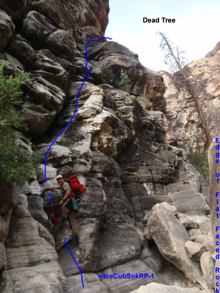
Diagram of the climb out of Ice Box Wash.
About 90 feet up you will
find a small ledge to the right. From this small ledge continue up
the canyon wall another 50 feet or so to a huge ledge. The huge
ledge has a rock overhang above it.
On the left side of the huge ledge is a deep chute continuing
steeply up the canyon wall. The chute is easy climbing part of the
way with high and narrow walls. As you get closer to the top
of the chute and it widens out a bit and there are a couple spots
that will take some effort to get up and are best done without a
pack.
As you get a little further up the chute there will be some
moderately heavy vegetation. Before entering the bushes traverse
right around to an open flat area. From this flat area, look for
cairns marking a route (wIceCubSnkRP-2).
The cairned route will curve around left and lead up a few easy
climbs over boulders up the slope to the south east. After a short
distance you will begin to get a good view of the high vertical
cliff wall to the south east and all of the gentle slope leading
to it. Continue south east until you get next to the vertical cliff
wall (wIceCubSnkRP-3). Then turn right (south west) and follow
along the base of the cliff wall. This is still part of the cairned
route.
The cairns are not placed often enough to be an easy follow. But
there are enough here and there to help you feel you are on the
right path. It is still best to already know which way to go. Take
a look at the picture showing the approximate route drawn on it.
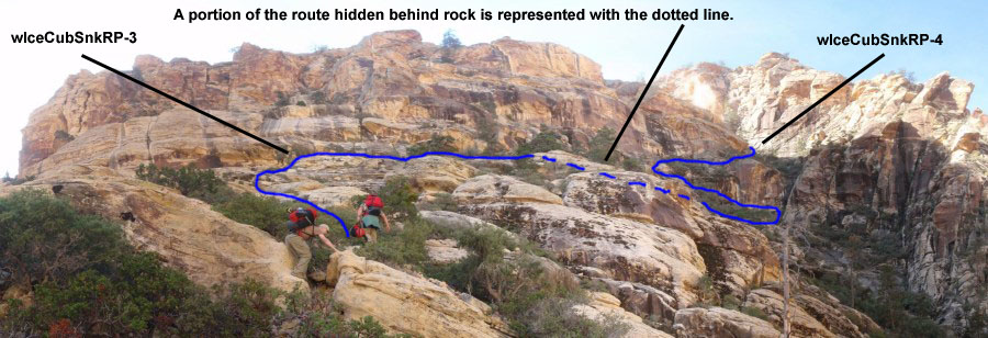
Diagram of the route after the first major climb out of Ice Box Wash.
The cairns lead roughly along the base of the cliff wall toward a
very large drainage (maybe considered a canyon?). As you get close
to the base of the drainage / canyon you will be greeted with a
vertical chute that accesses the more moderate slope above. The
chute is not able to be climbed. From the base of the chute climb
up left and traverse left along a ridge running along the bottom of
a large flat face of rock. At the other end of the ledge is and
easy climb up right along another ledge leading to the area above
the chute (wIceCubSnkRP-4).
Once above the chute continue east up the drainage / canyon. The
start of this area is up steep slick rock with little debris. This
area is very steep and will definitely get your attention in a few
spots. You will need to navigate around a couple spots that are too
steep to go straight up. Further up it is a little less steep and
is full of rock debris. As you ascend the area widens and is easier
to travel on the left side. Stay on the left side and keep going a
little further left as you climb up. About 900 feet up from the
chute you bypassed with the ledges, the drainage tops out. At the
top you will find a rocky ridge. The ridge has a point
(wIceCubSnkRP-5) on the left that gives great views of red rock and
offers a great spot for a snack and water break.
From the point, travel south along the left (east) side of the ridge
that runs to the south.
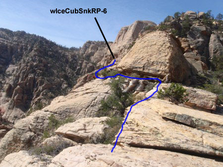
Diagram of the route leaving the point with a view over Red Rock Scenic Loop.
After traveling a little over 300 feet
along the left (east) side of the ridge, you will find a chute. The
chute is about 20 feet and has a shrub growing on the bottom left of
the chute which is shaded by overhanging rock. Climb up the chute.
After climbing up the chute continue going up along the rocks. As
you climb up from the chute keep an eye out on the left for a
large flat vertical rock face that is almost completely covered in
light green lichen. Make your way over to the base of the large
vertical flat green rock (wIceCubSnkRP-7).
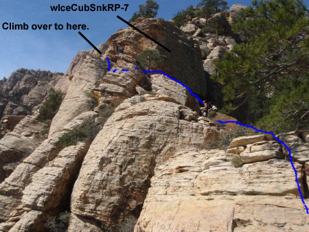
Diagram of the route up to the rock covered in light green lichen.
From the base of the large green rock, traverse around it to the
left (east). As you traverse follow the natural flow and stay
high. You will need to drop down a little to get to the last climb
up and around the large green rock.
Once around the large green rock follow a ledge that continues to
get wider and easier to follow. A couple hundred feet past the
large green rock the ledge turns into a bit more of a wide open area
(wIceCubSnkRP-8) with more cairns leading the way.
From the more open area of the ledge, continue southwest following
the cairns around the bend to the right. 200 – 300 feet along the
way you will find a passage with a pine tree growing in it and a lot
of shrubs along its bottom. Go through the passage
(wIceCubSnkRP-9) by traversing on the right side above the shrubs
growing along its bottom.
After getting through the passage, the area is a wide open steep
slope, dropping down south to the Ice Cube middle section. Continue
almost due southwest and follow the cairns angling along and down
the slope.
About 450 feet from the passage along the slope is a large rock that
looks like a pile of flat rocks that fell over (wIceCubSnkRP-10). Continue along the cairned route another 1000 feet or so until you
find yourself in the middle section wash of Ice Cube (jIceCubeSneak).
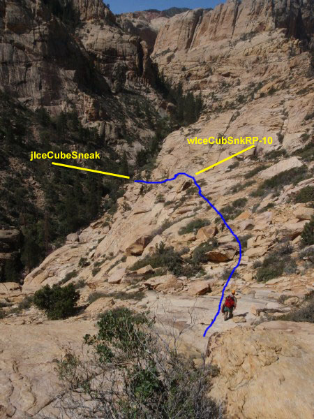
Diagram of the route down the last part into Ice Cube Canyon.
A little way down the wash you will find a drop that is bypassed by
climbing up and around to the left (LDC).
About 0.3 miles down canyon from where the sneak route drops into
the canyon is Rap 13, which is the first rap on this route.
The Canyoneering / Technical Section:
For canyoneering / technical, refer to the listing for the Ice Cube
Canyon full route, starting from point jIceCubeSneak.
The Exit:
For exit, refer to the listing for the Ice Cube Canyon full route.
Downloadable GPX files
available at
BG-Gear Store
(easier than manual entry and a great way to support
Bluugnome).
Waypoint naming convention and map symbol information can be found on the Glossary page.
Elevations are approximate.
BEFORE
manually entering coordinates set your system to WGS84 datum and Lat/Lon hddd.ddddd° coordinate format.
Inconsistent datum's and coordinate formats will result in location errors.
Click to show / expand the list of waypoints below........
| Ice Cube Sneak (1) - Approach |
- tIceBoxCyn
Lat/Lon (WGS84): N 36.15007
W -115.48403
Elev: 4,290 Feet
Ice Box Canyon Trail head on the Red Rock Scenic Loop
- jTrl2WshCnct1
Lat/Lon (WGS84): N 36.14451
W -115.49549
Elev: 4,530 Feet
A connector trail that joins the main trail and the wash. The connector trail meets the main trail here.
- wIceCubSnkRP-1
Lat/Lon (WGS84): N 36.14413
W -115.49818
Elev: 4,577 Feet
This is the spot where you leave the main wash and begin climbing up the left (south) side of the canyon wall. There is a huge rock in the wash next to the climb with a huge flat vertical face. There is also a very large dead pine tree up canyon about 100 feet.
- wIceCubSnkRP-2
Lat/Lon (WGS84): N 36.14287
W -115.49876
Elev: NaN Feet
Start of a route marked with cairns.
- wIceCubSnkRP-3
Lat/Lon (WGS84): N 36.14164
W -115.49803
Elev: 5,500 Feet
Point where the cairned route gets up to and turns right (south west) to follow along the near vertical rocky cliff side. Just an approximate point as there would be multiple ways through here.
- wIceCubSnkRP-4
Lat/Lon (WGS84): N 36.14072
W -115.49917
Elev: NaN Feet
Bottom portion of large drainage / canyon. This is just up from a vertical chute that could not be climbed but was bypassed by a series of ledges.
- wIceCubSnkRP-5
Lat/Lon (WGS84): N 36.14094
W -115.49671
Elev: 5,940 Feet
Point on the ridge at the top of the drainage / canyon. Good spot for a break with great views.
- wIceCubSnkRP-6
Lat/Lon (WGS84): N 36.14014
W -115.49698
Elev: NaN Feet
Chute about 20 feet tall. At the bottom left of the chute is a shrub growing under an overhanging rock.
- wIceCubSnkRP-7
Lat/Lon (WGS84): N 36.13984
W -115.49728
Elev: 6,010 Feet
Large rock face almost completely covered with light green lichen. Go to base of it then traverse left along it's base.
- wIceCubSnkRP-8
Lat/Lon (WGS84): N 36.13918
W -115.49767
Elev: 6,060 Feet
A bit more of an open area after the ledge after the large green rock. A cairned route begins again.
- wIceCubSnkRP-9
Lat/Lon (WGS84): N 36.13890
W -115.49824
Elev: NaN Feet
Passage along the ledge that grants access to wide open slop on the other side.
- wIceCubSnkRP-10
Lat/Lon (WGS84): N 36.13839
W -115.49955
Elev: NaN Feet
Large rock on slope that looks like a pile of flat rocks that fell over.
- jIceCubeSneak
Lat/Lon (WGS84): N 36.13684
W -115.50122
Elev: 5,670 Feet
This is where the sneak route into Ice Cube drops to the wash in the mid section of Ice Cube Canyon.
- yIceCubeLowrTp
Lat/Lon (WGS84): N 36.13712
W -115.49979
Elev: 5,660 Feet
Top entry for the Lower technical section of Ice Cube Canyon. This is the APPROXIMATE location of a 30 foot drop that is bypassed by climbing around LDC.
|
| Ice Cube Sneak (2) - The Canyon and Exit |
- yIceCubeLowrTp
Lat/Lon (WGS84): N 36.13712
W -115.49979
Elev: 5,660 Feet
Top entry for the Lower technical section of Ice Cube Canyon. This is the APPROXIMATE location of a 30 foot drop that is bypassed by climbing around LDC.
- dIceCubeR13
Lat/Lon (WGS84): N 36.13707
W -115.49672
Elev: NaN Feet
Rap 13 in Ice Cube Canyon. Anchored from a small tree and drops 60 feet to a pool (possible swimmer depending on water levels).
- dIceCubeR14
Lat/Lon (WGS84): N 36.13800
W -115.49531
Elev: NaN Feet
Rap 14 in Ice Cube Canyon. Anchored from 2 small boulders and drops 100 feet to a pool (possible swimmer depending on water levels). Hug the wall LDC in the pool for the shallowest water.
- dIceCubeR15-17
Lat/Lon (WGS84): N 36.13892
W -115.49399
Elev: NaN Feet
Raps 15 - 17 in Ice Cube.
Rap 15 is anchored from rock debris from a small rock fall and drops 20 feet down a wide slot.
Rap 16 is anchored from a crack high on the wall LDC and drops 15 feet RDC from one pool to another pool.
Rap 17 is anchored from a small tree about 20 feet up canyon of the rap and drops 12 feet to a small pool. Rap 17 can be easily bypassed by following a ledge RDC.
- dIceCubeR18
Lat/Lon (WGS84): N 36.14011
W -115.49345
Elev: NaN Feet
Rap 18 in Ice Cube Canyon. Was anchored from a large choke stone you stand on to start the rappel which made it awkward. It has been relocated to a small tree nearby and drops 15 feet over the choke stone. Can be down climbed by those 6 foot or taller.
- dIceCubeR19-20
Lat/Lon (WGS84): N 36.14113
W -115.49357
Elev: 5,040 Feet
Raps 19 - 20 in Ice Box.
Rap 19 is anchored from a small tree LDC and rap is 12 feet RDC down to a narrow pool that starts as a swimmer.
Rap 20 is anchored from a small tree and drops down a rock pile about 15 feet. Rap 20 is a pretty easy scramble / down climb and should be labeled as a down climb not a rap.
- dIceCubeR21
Lat/Lon (WGS84): N 36.14197
W -115.49252
Elev: NaN Feet
Rap 21 in Ice Cube. Anchored from a small tree RDC. Drops 30 feet under a huge (house sized) boulder to a large pool below. This is another favorite rap for this canyon. The canyon walls form the sides and the large boulder forms the roof of what feels like a large natural indoor swimming pool.
Rap 21 can be down climbed if you stay RDC before getting to the rap and work down a series of ledges.
- dIceCubeR22-23
Lat/Lon (WGS84): N 36.14262
W -115.49167
Elev: 4,700 Feet
Raps 22 - 23 in Ice Cube.
Rap 22 is anchored from a large boulder and drops 60 feet down a narrow slot as it twists to a narrow pool below. Be careful how you set the anchor to avoid sticking the rope in a couple cracks. Extending the anchor is awkward but a good idea.
Rap 23 is the final rap. It is anchored from a single bolt and hanger and 2 wedge devices in a crack. This is the only rap in the canyon that is not from a natural anchor. Drops 190' down a vertical wall that is sometimes a water fall. A Mea West set up is recommended since the start of this rap is in a very narrow crack. It makes it easier to get you and your pack through and helps take the weight off of your harness while on the long rap.
- yIceCubeLowrBt
Lat/Lon (WGS84): N 36.14453
W -115.49173
Elev: 4,430 Feet
Bottom of the Ice Cube Canyoneer route where it meets the wash near the Ice Box Canyon Trail.
- tIceBoxCyn
Lat/Lon (WGS84): N 36.15007
W -115.48403
Elev: 4,290 Feet
Ice Box Canyon Trail head on the Red Rock Scenic Loop
|