Canyoneering Route Description
Slideanide Canyon - 3A (or B) II
Poison Springs area, Utah
11-11-11, 9 people, 1 Day (Travel time in route 6.3 hours) - Time for both
Slideanide and Arscenic combined.

02-18-18, 7 people, 1 Day Travel time in route 4.2 hours) Slideanide only.
Time Required - 3 to 5 hours.
Distance - 3.8 miles Total, 0.5 miles Technical
Rappels - 2 Rappels, Longest Rappel 80 feet.
Elevation Range - 5180 - 4560 Feet
Shuttle Required - No Vehicle - High Clearance
(possibly 4WD if the road is in bad shape)
Permit Required - No
Rappelling and anchor gear, Ropes and or pull cords for rappels up
to 80 feet and 40 feet of 1 inch webbing for sling placement. Wet
suits may be desired in cold months. The water in the canyon
is in a few short pools.
If you like elevator style down climbing one of the slots in the
canyon offers a bit of fun. Most of the water (but not all)
can be avoided with some effort. Slideanide Canyon is short
fun route with a few scenic treat along the way. Only 2 raps
(possibly less depending on how you do things) and a lot of fun
short down climbs. The corkscrew slot near the end is
interesting as well.
To get to the Trailhead
From the junction of highway 95 and highway 276 (about 25.5
miles south of Hanksville), drive north on highway 95 about 5.8
miles to a dirt road turn off on the east side of the highway (extLoneCedarRd).
The dirt road is unnamed but will be referred to here as the
Lone Cedar Road. The road is not shown on some maps, but most
maps do show the Lone Cedar Reservoir that this road runs next
to which is about 0.3 miles off the highway. As of Dec 2010
this is near mile marker 20.
Turn right (east) onto the Lone Cedar Road. Drive 6.1 miles,
ignoring small side roads along the way, until you get to a Tee
in the road (wLoneCedrDP-01).
Turn left at the Tee and drive another 0.3 miles to where the
road crosses a wide drainage where there is ample parking on
both sides of the road (pkContrychSlid). This is where you will
park to start the route.
To leave the Exit Vehicle / Escape Pod
No exit vehicle is required. This is done as a loop hike.
GPS coordinate information listed at the bottom. For information about waypoint naming and map symbols, refer to the
Glossary page.

Click the links for maps of the route.
Map of the drive into the route.
Map of the entire route.
Map of the
exit section.
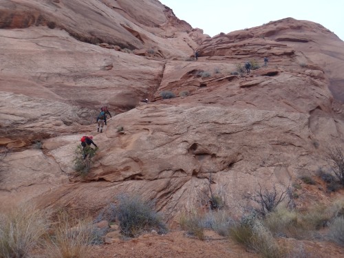
The Approach:
From the parking spot (pkContrychSlid) start walking north east
across the open rolling desert at a bearing of 35 degrees
(true north not magnetic).
About 0.27 miles from the car the you will drop down into a wide
drainage ( wSlideRP-01). The dirt you had been walking on up
to this drainage was a light reddish brown and the dirt on the other
side of the drainage is a darker reddish brown. After dropping
into the drainage find an acceptable spot to scramble up out of the
drainage on the other side to continue north west.
Once up out of the wash continue north east across the rolling
desert on a bearing of about 20 degrees. Continue north east
and route find your way through a convoluted mix of small hills.
About 2.2 miles along the desert will be another wide drainage
(wSlideRP-02). The floor of this drainage has a mix of dirt
and slick rock. Once down in the drainage turn left and walk
north west down the drainge.
About 250 feet down the wash (distance depends on where you dropped
into the drainage) will be a fork (wSlideRP-03). At this fork
turn right and walk north up the fork to the north.
About 700 feet up the fork in the drainage, the wash will begin to
end. As it does route find your way north up onto the hill
(wSlideRP-04).
Once up on the hill veer right (north east) and walk about 800 feet
over to the rim of Slideanide Canyon. As you get to the rim
walk along the rim to find the obvious head of the canyon (ySlideanideTp)
where the shallow wash drops down into a large deep slot.
The Canyoneering / Technical Section:
At the head of Slideanide Canyon (ySlideanideTp) is a short down
climb of about 8 feet to a shelf where rap 1 is.
Rap 1 is right at the head of Slideanide, is anchored from a large rock about
8 feet back from the drop and drops about 80 feet down a slightly
sloped wall with a 15 foot section of free hang about mid way down.
Note:
Optionally rap 1 can be bypassed. I have not explored these
bypass options but have been told they work.
Option one is to scramble down the LDC (east) side of the rim below
rap 1 to a ledge about half way down rap 1. Then down climb
down climb the up canyon side of the ledge to about mid way down rap
1. Then down climb the last part of rap 1 itself.
Option two is to find your way over to the top of a ravine about 150
feet down canyon of rap 1 on the RDC (west) side. Scramble
down the ravine to the canyon floor.
Down canyon of rap 1 are a few shallow pools that can be stemmed
over with a little work and a few easy short down climbs. As
you continue down canyon the walls become more narrow.
About 400 feet down canyon of rap 1 will be a down climb of about 25
feet (wSlideRP-05). This down climb is sloped with smooth
walls and is easily stemmed down. At the bottom of this down
climb could be a pool to wade through if it had recently rained.
Next stem down canyon under a set of choke stones.
About 100 feet down canyon is another down climb of about 20 feet.
The down climb is slightly sloped and easily stemmed down although
it looks intimidating from the top as well as the bottom. You
may find webbing here that previous parties have set to rap or hand
line this drop. There are plenty of features for both hands
and feet to assist with the down climb.
Continuing down canyon are more little pools to stem over if it had
recently rained.
A few hundred feet down canyon is another drop of about 20 feet
(wSlideRP-06) where you may find webbing rigged from rocks by
previous parties. This drop is down climbable. The down
climb has lots of good hand holds at the top but the first 7 feet or
so is moderately difficult. The rest of the down climb is
easy.
After the down climb you are starting down into a long narrow slot
of a little over 300 feet long and descends over several drops.
Each of these drops drops can be down climbed and most are
elevators. Less confident down climbers can rig rappels at
various points from choke stones in this slot. If you enjoy
elevator down climbs this is a pretty fun section! I assume
this section is where it the canyon got the name Slideanide.
Near the end of the slot are a couple pools that if full of water
will be a chest deep wade or possibly a swim for about 20 feet.
The first pool is easy to stem over but the second can be stemmed
over by taller people and a significant amount of work.
After the pool is an easy sloped down climb to another pool where
the canyon turns sharp right (wSlideRP-07). The pool at this
sharp right turn is not able to be stemmed around and will be chest
high or a swim for a few feet if full. This is also where a
side slot / ravine joins in from the LDC side as you enter the pool.
After turning sharp right travel is easy walking with one easy
down climb of about 10 feet and a short narrow section for a little
over 400 feet to where the canyon takes a wide but sharp left turn
(wSlideRP-08). As the canyon makes the left turn there is
another drainage joining in from RDC.
Just after going around the left turn is the start of another slot
with some fun in it. This next narrows is corkscrew like as
the drops in it twist around corners.
The first two down climbs in the corkscrew slot are both about 15
feet and relatively easy down climb / slides. A hand line is
useful for the first of these and can be rigged from a rock feature
near the top. The third drop in the corkscrew is what is
labeled as rap 2.
Rap 2 (dSlideR2) is the last drop in the corkscrew section, is anchored from
a pinch point at the top of the drop and drops a total of about 50 feet
to a pool as you exit the corkscrew slot. The first 10 feet of
rap 2 is a bit awkward as it starts out over an over hanging
boulder. The mid section is sloped but no rope is actually
needed. The last portion of rap 2 is down a sloped slot with a
slide of about 8 feet at the end down to a pool about knee deep.
Note:
Rap 2 is not a mandatory rappel but a rope is recommended rather you
rap or down climb. The first 15 feet is very awkward if you
choose to down climb over the boulder and the anchor webbing will be
VERY useful as a hand line to start the down climb. After the
first 15 feet the down climbing is easier with a short slide at the
bottom.
After the corkscrew the canyon is easy travel and starts to widen
out significantly. About 600 feet down canyon is a large
drainage joining in from RDC which is the bottom exit of
Constrychnine Canyon (yConstrychBt).
The Exit:
From the confluence of Constychnine and Slideanide Canyons (yConstrychBt)
there are two possible exits. Both exits meet and join up on
the rim to the west of Slideanide.
Since the bottom exit of Constrychnine Canyon and the bottom exit of
Slideanide Canyon are the same place both of these exit options can
be used for either canyon. To help avoid confusion in reading
the naming of my waypoints I will call one the Contrychnine Exit and
the other the Slideanide Exit. This does not mean one exit is
proffered over another depending on the canyon you descended.
The naming is is simply a way to reduce confusion.
The first option
will be called the Constrychnine Exit since it starts up the side of
the canyon wall directly across from the exit of Constrychnine.
This option is to start up west side of the canyon directly
across from Constrychnine and get up onto the rim. This exit
is 0.5 miles shorter than the second option but has one section of
class 4 scrambling that may be difficult for those that do not like
exposure.
The second option
will be called the Slideanide Exit since it continues farther down
the Slideanide Drainge before starting up out of the canyon system.
This option is 0.5 miles longer than option one. This
second option offers slightly easier scrambling but there is more of
it.
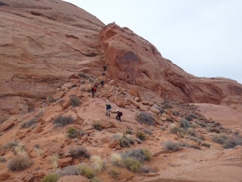
OPTION 1: ----------Contrychnine Exit (can be used for Constrychnine or Slideanide.
From the exit of Constrychnine Canyon (yConstrychBt) start
scrambling
up the west side of the canyon wall by starting up an almost ravine
like area.
Start up the slope up into a wide ravine like area west directly across from the exit of Contrychnine Canyon.
A little over 100 feet up out of the canyon the will be a view farther
up into the now more gentle sloped ravine (wConstrExRP-01). You
will also be able to see from here that the head of the ravine gets very
steep. From this point do not continue up the ravine but instead
scramble up onto the ridge to the right (north east) side.
About 400 along the ridge you will cross over the top of the ravine you
were traveling next to (wConstrExRP-02). When you get to the head
of the ridge, cross over to the west sided to get to the bottom of a
chute. Then start scrambling and up climbing the chute.
After crossing the head of the ravine start climbing up this chute.
Climbing up the chute has one spot that give the feeling of exposure.
If you are uncomfortable with exposure take your time here and move slow
there. The moves are not difficult but it is also not an easy
place for others to assist with a hand line so just move slow and take
your time.
When you get to the top of the chute (wConstrExRP-03) veer right and
walk around the bench you are on a short distance to find a way to
continue up and to the west.
About 150 feet farther you will be on a more gently sloped area where
you can turn left and start to travel south up the slick rock (jSlideExitJoin).
This is where the two options for the exit join and turn into one route.
Scroll down to the section for ROUTES JOIN to continue
this exit.
OPTION 2: -----------Slideanide Exit (can be used for Constrychnine or Slideanide.
From the exit of Constrychnine Canyon where it joins the Slidenide route (yConstrychBt)
walk north down canyon.
About 700 feet down canyon will be a drainage joining in from
the left or west (wSlideExRP-01). Shortly after is a larger
drainage joining in from the right.
Another 0.25 miles down canyon is another drainage that drops in
from the left or west. A few hundred feet before this side drainage
look for the start of a faint trail traversing up along the LDC side
of the canyon (wSlideExRP-02).
From the start of this faint trail, traverse down canyon and up the
side to a spot where you can climb up onto slick rock. The
spot to climb up is just before reaching the large side drainage.
If you do not find the faint trail you can route find your way up
the side of the canyon with the goal in mind of climbing up next to
the south side of the side drainage.
At the end of the faint trail, scramble up onto a sandstone nose
(wSlideExRP-03). The sandstone nose is just before reaching
the side drainage.
Once on the slick rock, route find your way up due south about 800
feet to a short up climb of about 5 feet (wSlideExRP-014).
Continue south up to a saddle (wSlideExRP-05). If you continue
straight over the saddle you would drop down another drainage.
Instead turn right and scramble up onto the slick rock to the west
before continuing south.
After getting up onto the slick rock above the saddle, continue
south about 250 feet to a dragons back feature (wSlideExRP-06).
Walk along the dragons back and continue south.
About 150 feet father is where the two exit routes join (jSlideExitJoin)
but will go almost un-noticed when using this exit.
Scroll down to the section for ROUTES JOIN to
continue this exit.
ROUTES JOIN:
About 350 feet south is a cliff band and a point slightly to the
right. Around the right (west) side of the point is an easy
scramble up the last part of the cliff band. At the top of the
cliff band (wSlideConRP-90) you will be greeted with lots of wide
open rolling desert.
From the top out of the climb (wSlideConRP-90) walk as due south as
the land will allow about 1.1 miles to get back to the road. The
natural flow of the land will steer you more east if you are not
careful. If you choose your route well you can follow various
ridges to make travel pretty easy. There will be a couple large
drainages to cross on the way though. If you are too far west the
drainages are more rugged and difficult to cross.
As you travel from the top out to the road you will find many areas
where foot traffic has made short social trails. There is no one
best route through this area. It is a series of rolling hills and
small drainages that you just have to figure your way across. You
could travel this route 10 times and likely take a slightly
different route out every time.
About 0.7 miles from the top out of the climb up will be a major
wash to cross (wSlideConRP-91). Then another 0.2 miles and you will
cross over another major wash (wSlideConRP-92). After the second major wash is
another 0.2 miles to the road (wSlideConRP-93).
When you get back to the road turn right (west) and walk back to
where you parked (pkContrychSlid). The distance on the road will
depend on where you met back with the road. Likely anywhere from
0.3 to 0.1 miles. You will not be able to see the road until you
are only about 20 feet from it. Don’t expect to see the road off in
the distance on your way to it.
Downloadable GPX files
available at
BG-Gear Store
(easier than manual entry and a great way to support
Bluugnome).
Waypoint naming convention and map symbol information can be found on the Glossary page.
Elevations are approximate.
BEFORE
manually entering coordinates set your system to WGS84 datum and Lat/Lon hddd.ddddd° coordinate format.
Inconsistent datum's and coordinate formats will result in location errors.
Click to show / expand the list of waypoints below........
| Slideanide (1) - Drive in to Trailhead. |
- extLoneCedarRd
Lat/Lon (WGS84): N 38.09720
W -110.62157
Elev: 5,090 Feet
Turn off for the road toward the Poison Springs canyons. The road is not shown on some maps but the Lone Dedar Reservoir which this road runs by is shown on most maps about 0.3 miles off the highway. Road is unnamed but will be referred to here as the Lone Cedar Road.
- wLoneCedrDP-01
Lat/Lon (WGS84): N 38.09207
W -110.53031
Elev: 5,170 Feet
Tee in the road on the drive into the Poison Springs Canyons. Turn left here to continue the drive in to Constrychnine Canyon.
- pkContrychSlid
Lat/Lon (WGS84): N 38.09252
W -110.52610
Elev: 5,175 Feet
Parking for Constrychnine and Slideanide. Lots of room here on both sides of the road.
|
| Slideanide (2) - Approach and The Canyon |
- pkContrychSlid
Lat/Lon (WGS84): N 38.09252
W -110.52610
Elev: 5,175 Feet
Parking for Constrychnine and Slideanide. Lots of room here on both sides of the road.
- wSlideRP-01
Lat/Lon (WGS84): N 38.09515
W -110.52376
Elev: NaN Feet
Approach route drops down into a drainge. THis is the drainge that would lead down to the top of Arscenic if you went down the drainge almost a half mile.
- wSlideRP-02
Lat/Lon (WGS84): N 38.09787
W -110.52273
Elev: NaN Feet
After traveling over a convoluted mix of rolling desert the approach route drops down to another drainge here.
- wSlideRP-03
Lat/Lon (WGS84): N 38.09836
W -110.52336
Elev: 5,110 Feet
Fork in the drainge. To continue toward Slideanide Canyon turn right and walk up the fork to the north.
- wSlideRP-04
Lat/Lon (WGS84): N 38.10046
W -110.52316
Elev: NaN Feet
Up on the hill above the top end of a drainage. This is about 800 feet from the side of Slideanide Canyon to the north.
- ySlideanideTp
Lat/Lon (WGS84): N 38.10161
W -110.52036
Elev: 5,120 Feet
Top entry for Slideanide Canyon. This is also where rap 1 is. Rap 1 is anchored from
- wSlideRP-05
Lat/Lon (WGS84): N 38.10248
W -110.52136
Elev: NaN Feet
Start of the down climb section and begins approx here with a down climb of about 25 feet that is sloped and easily stemmed down.
- wSlideRP-06
Lat/Lon (WGS84): N 38.10375
W -110.52241
Elev: NaN Feet
This is where the long narrow section with elevators starts. At the start here is a drop to down climb of about 20 feet with the first 7 being a little challenging.
- wSlideRP-07
Lat/Lon (WGS84): N 38.10399
W -110.52350
Elev: NaN Feet
This is where the canyon takes a sharp right as you drop into an unavoidable pool after the slot with the fun elevators. This is also where a side slot / ravine joins in from LDC.
- wSlideRP-08
Lat/Lon (WGS84): N 38.10519
W -110.52327
Elev: NaN Feet
The canyon takes a wide but sharp left turn here before entering teh corkscrew section.
- dSlideR2
Lat/Lon (WGS84): N 38.10530
W -110.52385
Elev: NaN Feet
Rap 2 - Slideanide Canyon. Anchored from the boulder you climb over. Drops about 50 feet total with the first 10 feet is awkward. This drop can be down climbed but the start is very difficult.,
- yConstrychBt
Lat/Lon (WGS84): N 38.10686
W -110.52467
Elev: 4,610 Feet
Bottom exit of Constrychnine Canyon where it joins in to the Slidenide route.
|
| Slideanide (3) - First part of Standard Exit |
- yConstrychBt
Lat/Lon (WGS84): N 38.10686
W -110.52467
Elev: 4,610 Feet
Bottom exit of Constrychnine Canyon where it joins in to the Slidenide route.
- wSlideExRP-01
Lat/Lon (WGS84): N 38.10874
W -110.52528
Elev: NaN Feet
First canyon down stream of Constrychnine that joins in from the left (west).
- wSlideExRP-02
Lat/Lon (WGS84): N 38.11169
W -110.52709
Elev: 4,565 Feet
Faint trail climbing up the LDC side of the canyon toward anoher side drainage.
- wSlideExRP-03
Lat/Lon (WGS84): N 38.11216
W -110.52766
Elev: NaN Feet
Sandstone nose to scramble up onto after a faint trail traversing up out of the wash below.
- wSlideExRP-04
Lat/Lon (WGS84): N 38.11014
W -110.52789
Elev: NaN Feet
Short up climb of about 5 feet.
- wSlideExRP-05
Lat/Lon (WGS84): N 38.10947
W -110.52741
Elev: NaN Feet
The climb up gets up to a saddle here. Continuing straight ahead would drop down another side drainage. Turn right to scramble up onto the slick rock to the west before continuing south.
- wSlideExRP-06
Lat/Lon (WGS84): N 38.10877
W -110.52729
Elev: NaN Feet
Dragons back feature to walk along.
- jSlideExitJoin
Lat/Lon (WGS84): N 38.10836
W -110.52721
Elev: 4,920 Feet
This is where the two exit route options for Constrychnine and Slideanide Canyons join into one route.
|
| Slideanide (4) - Short cut to bypass first part of Standard Exit |
- yConstrychBt
Lat/Lon (WGS84): N 38.10686
W -110.52467
Elev: 4,610 Feet
Bottom exit of Constrychnine Canyon where it joins in to the Slidenide route.
- wConstrExRP-01
Lat/Lon (WGS84): N 38.10732
W -110.52538
Elev: NaN Feet
Climb up out of the canyon levels off a little here. Do not continue up the ravine but insteade scramble up onto the ridge to the right (north east).
- wConstrExRP-02
Lat/Lon (WGS84): N 38.10807
W -110.52620
Elev: 4,812 Feet
Ridge crosses along the top of the the ravine.
- wConstrExRP-03
Lat/Lon (WGS84): N 38.10815
W -110.52686
Elev: 4,925 Feet
Top of the chute. Walk right around the bench to find a way to continue up and west.
- jSlideExitJoin
Lat/Lon (WGS84): N 38.10836
W -110.52721
Elev: 4,920 Feet
This is where the two exit route options for Constrychnine and Slideanide Canyons join into one route.
|
| Slideanide (5) - Last part of Exit |
- jSlideExitJoin
Lat/Lon (WGS84): N 38.10836
W -110.52721
Elev: 4,920 Feet
This is where the two exit route options for Constrychnine and Slideanide Canyons join into one route.
- wSlideConRP-90
Lat/Lon (WGS84): N 38.10731
W -110.52779
Elev: 5,053 Feet
Top out of the climb up out of the canyon. The last part of the climb up is on the west side of a point.
- wSlideConRP-91
Lat/Lon (WGS84): N 38.09813
W -110.52376
Elev: NaN Feet
Major wash to cross.
- wSlideConRP-92
Lat/Lon (WGS84): N 38.09471
W -110.52232
Elev: NaN Feet
Another major wash to cross over.
- wSlideConRP-93
Lat/Lon (WGS84): N 38.09233
W -110.52213
Elev: 5,180 Feet
Back on the road from the Constrychnine and Slideanide exit.
- pkContrychSlid
Lat/Lon (WGS84): N 38.09252
W -110.52610
Elev: 5,175 Feet
Parking for Constrychnine and Slideanide. Lots of room here on both sides of the road.
|