Canyoneering Route Description
Constrychnine Canyon - 3A (or B) III
Poison Springs area, Utah.
11-14-10, 4 people, 1 Day (Travel time in route 6 hours)

12-04-10, 3 people, 1 Day (Travel time in route 5.5 hours)
Time Required - 5 to 7 hours
Distance - 4.8 miles Total, 0.7 miles Technical
Rappels - 4 Rappels, Longest Rappel 165 feet.
Elevation Range - 5300 - 4560 Feet
Shuttle Required - No Vehicle -
High Clearance (4WD if road conditions are bad)
Permit Required - No
Rappelling and anchor gear, Ropes and or pull cords for rappels up
to 165 feet, 60 feet of 1 inch webbing for sling placement. Wet
suits may be needed if the canyon fills with water on a cold day.
Most of the time wet suits will likely not be needed.
The later portion of the route out of Constrychnine travels across
rolling hills and drainages for a little over a mile. There are no
definite land marks or obstacles so it is easy to get steered around
by the land and not know it. GPS points or a map and compass may
prevent you from getting way off course and having an epic in the
flat lands on the hike back to a vehicle you have lost.
Contrychnine Canyon is a fun half day route. Route finding skills
are a good asset on this route since the route in and route out can
be very difficult to describe in this area.
To get to the Trailhead
From the junction of highway 95 and highway 276 (about 25.5
miles south of Hanksville), drive north on highway 95 about 5.8
miles to a dirt road turn off on the east side of the highway (extLoneCedarRd).
The dirt road is unnamed but will be referred to here as the
Lone Cedar Road. The road is not shown on some maps, but most
maps do show the Lone Cedar Reservoir that this road runs next
to which is about 0.3 miles off the highway. As of Dec 2010
this is near mile marker 20.
Turn right (east) onto the Lone Cedar Road. Drive 6.1 miles,
ignoring small side roads along the way, until you get to a Tee
in the road (wLoneCedrDP-01).
Turn left at the Tee and drive another 0.3 miles to where the
road crosses a wide drainage where there is ample parking on
both sides of the road (pkContrychSlid). This is where you will
park to start the route.
To leave the Exit Vehicle / Escape Pod
No exit vehicle is required. This is done as a loop hike.
GPS coordinate information listed at the bottom. For information about waypoint naming and map symbols, refer to the
Glossary page.

Click the links for maps of the route.
Map of the drive into the route.
Map of the entire route.
Map of the
exit section.
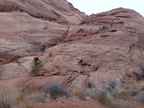
The Approach:
From the parking area, continue walking east along the road. About
0.5 miles along the road you will cross over a wash. Just after the
wash the road gets sandy and rough which may cause problems for most
vehicles if driving.
Another 0.6 miles, the road will top out and begin to turn right
toward the southeast (wContrychRP-01). This is about 1.1 miles
along the road after leaving the parking spot. Do not follow the
road around this long sweeping corner. Instead turn left to leave
the road and walk northwest across the desert at a bearing of 340
degrees.
Note:
You can leave the road earlier if you like and just route
find your way across the desert to locate the drop in point. The
route described here travels over slightly easier terrain to walk
on. There is no one easiest route into the canyon.
From where you leave the road (wContrychRP-01), walk northwest
across the desert at a bearing of 340 degrees. The drop in point at
the head of the canyon is 0.7 miles away.
About 0.3 miles after leaving the road, you will cross a drainage
that leads down to the head of Slidenide (wContrychRP-02). Continue
across the drainage staying northwest across the desert.
Continue another 0.3 miles northwest across the desert crossing over
a few small drainages along the way until you drop into a larger
drainage (yConstrychTp). This larger drainage is the top of
Constrychnine. If you have dropped into the correct spot (yConstrychTp)
you will have a drop in the wash of about 20 feet to continue down
canyon.
The Canyoneering / Technical Section:
From the top of Constrychnine (yConstrychTp), bypass the 20 foot
drop by scrambling around RDC and down to the canyon floor.
Follow down canyon a little over 500 feet to a drop of about 40 feet
that is easily bypassed by scrambling down on the RDC side. About
200 feet after the 40 foot drop is the top of rap 1.
Rap 1 (dConstrychR1) is anchored RDC from one of many large rocks
about 15 feet back from the drop. The start of rap 1 is a little
awkward going over an overhanging section. There is a ledge about
15 feet down the rap then a short walk down to a sloped wall the
rest of the way down. The sloped wall is fun to run down while in
rappel. Rap 1 is about 115 feet.
Down canyon of rap 1 is easy travel with a few easy spots to
scramble down. About 700 feet down canyon is a large bowl shaped
area on the LDC side. The canyon turns to the right as it passes
the bowl shaped area. As it turns right there is a down climb of
about 10 feet which is easily down climbed by stemming down. After
the down climb it is easy travel another 300 feet to the top of rap
2.
Rap 2 (dConstrychR2) is anchored from a large rock RDC near the top
of the drop. Rap 2 looks big from the top as you look over. Rap 2
drops about 165 feet down to another narrow area.
About 50 feet down canyon of the bottom of rap 2 is a down climb of
about 40 feet in a tight section. The down climb can be anchored
from a choke stone for those who feel they need a hand line or want
to rap it. Starting is easy as you start over the choke stone.
Part way down the LDC side flares out making it challenging to stem
down as the walls get further apart. The wall on the RDC side is
semi featured and actually does work well for down climbing although
your eyes tell you different.
After the down climb travel down canyon a hundred feet or so by
stemming over a narrow area then walking and scrambling over easy
obstacles. A short distance down canyon is another down climb of
about 12 feet. After the down climb it is a walk of about 150 feet
down canyon to the top of rap 3.
Rap 3 (dConstrychR3) is about 500 feet down canyon of rap 2. Rap 3
can be anchored from choke stones in the water course or from some
choke stones high over head RDC of the drop. Rap 3 drops about 90
feet with a ledge near the bottom of the rap. If the canyon is
holding water there may be a small pool at the bottom of rap 3.
The canyon is deep and dark at the bottom of rap 3 for a little
ways, but is easy walking and light scrambling.
A little over 300 feet down canyon of rap 3 the canyon takes a sharp
right then left where there is another drop. This drop is rap 4.
Rap 4 (dConstrychR4) is about 300 feet down canyon of rap 3 and is
anchored from a dead man anchor in a shallow sand filled pothole
near the top of the drop. Rap 4 drops about 35 feet to a sloped
ledge above a pool. After getting down to the ledge, traverse over
to avoid the pool. Rap 4 can be down climbed since it is down a
sloped featured wall. If down climbing the anchor should still be
used to provide a hand line. The hand line could prevent you from
slipping down into the pool below.
Down canyon of rap 4 is very scenic and is easy travel with some
light scrambling along the way. About 1000 feet down canyon of rap
4 is the end of the Constrychnine Canyon (yConstrychBt). This is
where it joins in with the Slidenide route.
The Exit:
From the confluence of Constychnine and Slideanide Canyons (yConstrychBt)
there are two possible exits. Both exits meet and join up on
the rim to the west of Slideanide.
Since the bottom exit of Constrychnine Canyon and the bottom exit of
Slideanide Canyon are the same place both of these exit options can
be used for either canyon. To help avoid confusion in reading
the naming of my waypoints I will call one the Contrychnine Exit and
the other the Slideanide Exit. This does not mean one exit is
proffered over another depending on the canyon you descended.
The naming is is simply a way to reduce confusion.
The first option
will be called the Constrychnine Exit since it starts up the side of
the canyon wall directly across from the exit of Constrychnine.
This option is to start up west side of the canyon directly
across from Constrychnine and get up onto the rim. This exit
is 0.5 miles shorter than the second option but has one section of
class 4 scrambling that may be difficult for those that do not like
exposure.
The second option
will be called the Slideanide Exit since it continues farther down
the Slideanide Drainge before starting up out of the canyon system.
This option is 0.5 miles longer than option one. This
second option offers slightly easier scrambling but there is more of
it.
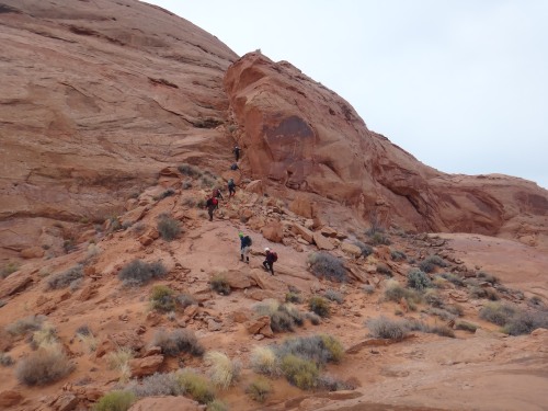
OPTION 1: ----------Contrychnine Exit (can be used for Constrychnine or Slideanide.
From the exit of Constrychnine Canyon (yConstrychBt) start
scrambling
up the west side of the canyon wall by starting up an almost ravine
like area.
Start up the slope up into a wide ravine like area west directly across from the exit of Contrychnine Canyon.
A little over 100 feet up out of the canyon the will be a view farther
up into the now more gentle sloped ravine (wConstrExRP-01). You
will also be able to see from here that the head of the ravine gets very
steep. From this point do not continue up the ravine but instead
scramble up onto the ridge to the right (north east) side.
About 400 along the ridge you will cross over the top of the ravine you
were traveling next to (wConstrExRP-02). When you get to the head
of the ridge, cross over to the west sided to get to the bottom of a
chute. Then start scrambling and up climbing the chute.
After crossing the head of the ravine start climbing up this chute.
Climbing up the chute has one spot that give the feeling of exposure.
If you are uncomfortable with exposure take your time here and move slow
there. The moves are not difficult but it is also not an easy
place for others to assist with a hand line so just move slow and take
your time.
When you get to the top of the chute (wConstrExRP-03) veer right and
walk around the bench you are on a short distance to find a way to
continue up and to the west.
About 150 feet farther you will be on a more gently sloped area where
you can turn left and start to travel south up the slick rock (jSlideExitJoin).
This is where the two options for the exit join and turn into one route.
Scroll down to the section for ROUTES JOIN to continue
this exit.
OPTION 2: -----------Slideanide Exit (can be used for Constrychnine or Slideanide.
From the exit of Constrychnine Canyon where it joins the Slidenide route (yConstrychBt)
walk north down canyon.
About 700 feet down canyon will be a drainage joining in from
the left or west (wSlideExRP-01). Shortly after is a larger
drainage joining in from the right.
Another 0.25 miles down canyon is another drainage that drops in
from the left or west. A few hundred feet before this side drainage
look for the start of a faint trail traversing up along the LDC side
of the canyon (wSlideExRP-02).
From the start of this faint trail, traverse down canyon and up the
side to a spot where you can climb up onto slick rock. The
spot to climb up is just before reaching the large side drainage.
If you do not find the faint trail you can route find your way up
the side of the canyon with the goal in mind of climbing up next to
the south side of the side drainage.
At the end of the faint trail, scramble up onto a sandstone nose
(wSlideExRP-03). The sandstone nose is just before reaching
the side drainage.
Once on the slick rock, route find your way up due south about 800
feet to a short up climb of about 5 feet (wSlideExRP-014).
Continue south up to a saddle (wSlideExRP-05). If you continue
straight over the saddle you would drop down another drainage.
Instead turn right and scramble up onto the slick rock to the west
before continuing south.
After getting up onto the slick rock above the saddle, continue
south about 250 feet to a dragons back feature (wSlideExRP-06).
Walk along the dragons back and continue south.
About 150 feet father is where the two exit routes join (jSlideExitJoin)
but will go almost un-noticed when using this exit.
Scroll down to the section for ROUTES JOIN to
continue this exit.
ROUTES JOIN:
About 350 feet south is a cliff band and a point slightly to the
right. Around the right (west) side of the point is an easy
scramble up the last part of the cliff band. At the top of the
cliff band (wSlideConRP-90) you will be greeted with lots of wide
open rolling desert.
From the top out of the climb (wSlideConRP-90) walk as due south as
the land will allow about 1.1 miles to get back to the road. The
natural flow of the land will steer you more east if you are not
careful. If you choose your route well you can follow various
ridges to make travel pretty easy. There will be a couple large
drainages to cross on the way though. If you are too far west the
drainages are more rugged and difficult to cross.
As you travel from the top out to the road you will find many areas
where foot traffic has made short social trails. There is no one
best route through this area. It is a series of rolling hills and
small drainages that you just have to figure your way across. You
could travel this route 10 times and likely take a slightly
different route out every time.
About 0.7 miles from the top out of the climb up will be a major
wash to cross (wSlideConRP-91). Then another 0.2 miles and you will
cross over another major wash (wSlideConRP-92). After the second major wash is
another 0.2 miles to the road (wSlideConRP-93).
When you get back to the road turn right (west) and walk back to
where you parked (pkContrychSlid). The distance on the road will
depend on where you met back with the road. Likely anywhere from
0.3 to 0.1 miles. You will not be able to see the road until you
are only about 20 feet from it. Don’t expect to see the road off in
the distance on your way to it.
Downloadable GPX files
available at
BG-Gear Store
(easier than manual entry and a great way to support
Bluugnome).
Waypoint naming convention and map symbol information can be found on the Glossary page.
Elevations are approximate.
BEFORE
manually entering coordinates set your system to WGS84 datum and Lat/Lon hddd.ddddd° coordinate format.
Inconsistent datum's and coordinate formats will result in location errors.
Click to show / expand the list of waypoints below........
| Constrychnine (1) - Drive in to Trailhead |
- extLoneCedarRd
Lat/Lon (WGS84): N 38.09720
W -110.62157
Elev: 5,090 Feet
Turn off for the road toward the Poison Springs canyons. The road is not shown on some maps but the Lone Dedar Reservoir which this road runs by is shown on most maps about 0.3 miles off the highway. Road is unnamed but will be referred to here as the Lone Cedar Road.
- wLoneCedrDP-01
Lat/Lon (WGS84): N 38.09207
W -110.53031
Elev: 5,170 Feet
Tee in the road on the drive into the Poison Springs Canyons. Turn left here to continue the drive in to Constrychnine Canyon.
- pkContrychSlid
Lat/Lon (WGS84): N 38.09252
W -110.52610
Elev: 5,175 Feet
Parking for Constrychnine and Slideanide. Lots of room here on both sides of the road.
|
| Constrychnine (2) - Approach and The Canyon |
- pkContrychSlid
Lat/Lon (WGS84): N 38.09252
W -110.52610
Elev: 5,175 Feet
Parking for Constrychnine and Slideanide. Lots of room here on both sides of the road.
- wSlideConRP-93
Lat/Lon (WGS84): N 38.09233
W -110.52213
Elev: 5,180 Feet
Back on the road from the Constrychnine and Slideanide exit.
- wContrychRP-01
Lat/Lon (WGS84): N 38.09621
W -110.50882
Elev: 5,300 Feet
Road tops out here. Leave the road here and turn left (nortwest) to start walking across the desert.
- wContrychRP-02
Lat/Lon (WGS84): N 38.10064
W -110.51100
Elev: NaN Feet
Cross over a draingae here. This drainage leads down to the top of Slidenide.
- yConstrychTp
Lat/Lon (WGS84): N 38.10510
W -110.51362
Elev: 5,205 Feet
Top entry for Constrychnine. A drop of about 20 feet in the wash that can be easily bypassed RDC.
- dConstrychR1
Lat/Lon (WGS84): N 38.10611
W -110.51511
Elev: NaN Feet
Rap 1 - Constrychnine Canyon. Drops about 115 feet and is anchored RDC from a one of many large rocks at the top about 15 feet back. Starts out over an overhanging ledge to a ledge about 15 feet down then a short wak over to a smooth sloped wall the rest of the way down.
- dConstrychR2
Lat/Lon (WGS84): N 38.10584
W -110.51819
Elev: NaN Feet
Rap 2 - Constrychnine Canyon. Anchored from a large rock RDC at the top of the drop and drops about 165 feet to a tight section of canyon.
- dConstrychR3
Lat/Lon (WGS84): N 38.10651
W -110.51968
Elev: NaN Feet
Rap 3 - Constrychnine Canyon. Drops a total of about 90 feet with a ledge near the bottom. Anchored from either choke stones in the water course or from a set of choke stones high over head RDC of the drop.
- dConstrychR4
Lat/Lon (WGS84): N 38.10702
W -110.52105
Elev: NaN Feet
Rap 4 - Constrychnine Canyon. Ancored from a dead man and drops about 35 feet to a ledge over a pool of water.
- yConstrychBt
Lat/Lon (WGS84): N 38.10686
W -110.52467
Elev: 4,610 Feet
Bottom exit of Constrychnine Canyon where it joins in to the Slidenide route.
|
| Constrychnine (3) - First part of Standard Exit |
- yConstrychBt
Lat/Lon (WGS84): N 38.10686
W -110.52467
Elev: 4,610 Feet
Bottom exit of Constrychnine Canyon where it joins in to the Slidenide route.
- wSlideExRP-01
Lat/Lon (WGS84): N 38.10874
W -110.52528
Elev: NaN Feet
First canyon down stream of Constrychnine that joins in from the left (west).
- wSlideExRP-02
Lat/Lon (WGS84): N 38.11169
W -110.52709
Elev: 4,565 Feet
Faint trail climbing up the LDC side of the canyon toward anoher side drainage.
- wSlideExRP-03
Lat/Lon (WGS84): N 38.11216
W -110.52766
Elev: NaN Feet
Sandstone nose to scramble up onto after a faint trail traversing up out of the wash below.
- wSlideExRP-04
Lat/Lon (WGS84): N 38.11014
W -110.52789
Elev: NaN Feet
Short up climb of about 5 feet.
- wSlideExRP-05
Lat/Lon (WGS84): N 38.10947
W -110.52741
Elev: NaN Feet
The climb up gets up to a saddle here. Continuing straight ahead would drop down another side drainage. Turn right to scramble up onto the slick rock to the west before continuing south.
- wSlideExRP-06
Lat/Lon (WGS84): N 38.10877
W -110.52729
Elev: NaN Feet
Dragons back feature to walk along.
- jSlideExitJoin
Lat/Lon (WGS84): N 38.10836
W -110.52721
Elev: 4,920 Feet
This is where the two exit route options for Constrychnine and Slideanide Canyons join into one route.
|
| Constrychnine (4) - Short cut to bypass first part of Standard Exit |
- yConstrychBt
Lat/Lon (WGS84): N 38.10686
W -110.52467
Elev: 4,610 Feet
Bottom exit of Constrychnine Canyon where it joins in to the Slidenide route.
- wConstrExRP-01
Lat/Lon (WGS84): N 38.10732
W -110.52538
Elev: NaN Feet
Climb up out of the canyon levels off a little here. Do not continue up the ravine but insteade scramble up onto the ridge to the right (north east).
- wConstrExRP-02
Lat/Lon (WGS84): N 38.10807
W -110.52620
Elev: 4,812 Feet
Ridge crosses along the top of the the ravine.
- wConstrExRP-03
Lat/Lon (WGS84): N 38.10815
W -110.52686
Elev: 4,925 Feet
Top of the chute. Walk right around the bench to find a way to continue up and west.
- jSlideExitJoin
Lat/Lon (WGS84): N 38.10836
W -110.52721
Elev: 4,920 Feet
This is where the two exit route options for Constrychnine and Slideanide Canyons join into one route.
|
| Constrychnine (5) - Last part of Exit |
- jSlideExitJoin
Lat/Lon (WGS84): N 38.10836
W -110.52721
Elev: 4,920 Feet
This is where the two exit route options for Constrychnine and Slideanide Canyons join into one route.
- wSlideConRP-90
Lat/Lon (WGS84): N 38.10731
W -110.52779
Elev: 5,053 Feet
Top out of the climb up out of the canyon. The last part of the climb up is on the west side of a point.
- wSlideRP-04
Lat/Lon (WGS84): N 38.10046
W -110.52316
Elev: NaN Feet
Up on the hill above the top end of a drainage. This is about 800 feet from the side of Slideanide Canyon to the north.
- wSlideConRP-91
Lat/Lon (WGS84): N 38.09813
W -110.52376
Elev: NaN Feet
Major wash to cross.
- wSlideConRP-92
Lat/Lon (WGS84): N 38.09471
W -110.52232
Elev: NaN Feet
Another major wash to cross over.
- wSlideConRP-93
Lat/Lon (WGS84): N 38.09233
W -110.52213
Elev: 5,180 Feet
Back on the road from the Constrychnine and Slideanide exit.
- pkContrychSlid
Lat/Lon (WGS84): N 38.09252
W -110.52610
Elev: 5,175 Feet
Parking for Constrychnine and Slideanide. Lots of room here on both sides of the road.
|