Canyoneering Route Description
Morocco Canyon - 3B I
North Wash, Utah.
05-23-09, 2 people, 1 Day (Travel time in route 2.5 hours)

09-23-16,
8 people, 1 Day (Travel time in route 3.5 hours)
Time Required - 2 to 4 hours
Distance - 2.1 miles Total, 0.3 miles Technical
Rappels - 6 Rappels, Longest Rappel 45 feet.
Elevation Range - 4140 - 4390 Feet
Shuttle Required -No Vehicle - Passenger
Permit Required - No
Rappelling and anchor gear, Ropes and or pull cords for rappels up
to 45 feet and 30 feet of 1†webbing for sling placement.
Morocco Canyon is another fun very short adventure. You will get a
little wet on this route. There are a few scenic surprises in this
canyon so take time to enjoy where you are. Information originally
came from the
Mini-Slot Guide to the Colorado Plateau.
To get to the Trailhead
From the Hog Springs Rest Area, drive North on Utah highway 95
1.0 miles and park alongside the east side of the road (pkCasablanca).
There is a very large area for parking here. There will be a
wide canyon heading east away from the road which is called Casa
Blanca.
To leave the Exit Vehicle / Escape Pod
No exit vehicle is needed. This is done as a loop route.
GPS coordinate information listed at the bottom. For information about waypoint naming and map symbols, refer to the
Glossary page.

Click the links for maps of the route.
Map of the entire route.
The Approach:
From the parking area for Casa Blanca Canyon (pkCasablanca) look south
across a drainage and over to the sand stone mountain side. Look
for a prominent flat rock face with dark desert varnish on it. The
route around the mountain will traverse over the top of that
prominent rock face.
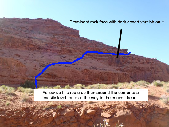
The line drawn shows the route up the first climb.
Walk from the parking spot to the road and walk south to get to the
other side of drainage. Once on the other side of the drainage walk
about 275 feet to the base of the sand stone mountain near a bowl
shaped indent (wMoroccoRP-01). Start the climb up the slope in this
bowl shaped indentation.
The climb up the side of the mountain does not involve any
climbing. If you need climbing skills then you are not following
the best route up. You will however have a few spots where some
light scrambling will be needed.
A little over 100 feet from the start of the climb up the slope
becomes a little less steep. Continue up the slope and continue
traversing right (south). You will be able to see the prominent
flat rock face with the dark desert varnish on it. You should
notice 2 ledges running toward you from the top of the rock face.
Your goal is to get up onto then follow the top of these two ledges
then walk them over to the top of the prominent rock face.
Continue traversing as you climb and head for the left (north) end
of the top of the two ledges leading over to the top of the rock
face. To get onto the top of the ledge (wMoroccoRP-02) you will
need to scramble a little so hands are needed here. This is about
450 feet from where you started up the slope from the desert floor.
Traverse about 350 feet along the ledge and follow it over to the
top of the prominent rock face (wMoroccoRP-03) you have been aiming
for.
From the top of the rock face the route is mostly level. Follow
north then east as the route curves around and starts to travel up
along the rim of Morocco Canyon. There are sections that are
difficult to follow but they are very short. Most of the route has
a very easy to follow path.
A few hundred feet up, the path will be a field of rock fall debris
where the route is hard to follow. It is short and your goal is to
travel through and stay pretty level. Do not try to climb or
descend. Just after the rock fall debris the route dumps out onto
smooth slick rock with some good views down into the canyon.
Part way along this slick rock will be a ledge about 20 feet down
and closer to the rim (wMoroccoRP-04). There is a gentle slope down
to the lower ledge that looks inviting. Do not drop down but stay
on the higher ledge and continue east along the rim on the higher
ledge.
Another 400 feet will put you at the head of the canyon. This is at
the top of a deep and kind of narrow slot (yMoroccoTp). Up canyon
from here is very wide open.
The Canyon / Technical Section:
At the head of the canyon (yMoroccoTp) at the start of the deep kind
of narrow slot is also rap 1.
Rap 1 (yMoroccoTp) is anchored from a cairn anchor and drops about
40 feet into the deep narrow slot. The bottom of rap 1 is sand
filled so water might dig it out a bit deeper so plan on about 45
feet.
About 50 feet after rap 1 is a tight squeeze for about 15 feet then
a drop of about 25 feet. The drop sometimes has webbing rigged for
a rappel but is actually an easy sloped down climb. At the bottom
of the drop is a pothole that may be about chest deep in water if it
were full. There is standing room at the top of the pothole for a
couple of people. It is not too difficult to traverse across the
pothole RDC. Place a foot out about half way across on the right
side then push off the left wall with your hands to step slash hop
to the other side. Once the first person is across they can help
the rest over by pulling their arms as they hop over.
On the other side of the pothole is a rock feature that should
capture your attention but is left out of this description so you
can have the surprise of finding it. No worries, you cannot miss
it.
Just around the corner after the pothole is a narrow slot with a
large choke stone jammed in it. On the other side of the choke
stone is a drop that looks larger than it is and drops down to a
wide open section of canyon. This drop is rap 2.
Rap 2 (dMoroccoR2) is anchored from a large choke stone large choke
stone overhead in a tight slot and drops down a sloped slot then
opens to a vertical wall which then gives way to some overhanging
free rap. The total drop is about 35 feet. There is a large hole /
alcove in the wall along the rap. 35 feet of rope will drop you
onto a ledge that is about 15 feet up from the canyon floor with an
easy walk off RDC.
Just down canyon of rap 2 LDC is a view of the huge alcove you could
see from the rim as you hiked to the head of the canyon. A few
hundred feet down canyon of rap 2 the wide open canyon drops into a
narrow section that is not very deep but soon get a little deeper
after a few more hundred feet. In that deeper section is a drop of
about 20 feet which I am calling rap 3.
Rap 3 (dMoroccoR3) is anchored from a choke stone embedded in the
wash and drops about 20 feet. It is possible to down climb rap 3
but it looks difficult from the top so I am labeling it a rappel.
The start of rap 3 goes over a boulder and has an overhang under the
boulder making the rap a bit awkward.
About 40 feet after rap 3 the canyon opens up kind of wide again.
Another 200 feet down canyon are a couple of pools one right after
the other at the bottom of down climbs (wMoroccoRP-05). Each pool
can be stemmed over if you like. It is also possible to bypass the
pools by climbing up high RDC.
Rap 4 (dMoroccoR4-5) is about 100 feet after the pools. Rap 4 is
anchored from a cairn anchor and drops about 20 feet to a pool that
can be anywhere from ankle deep to belly high depending on water
levels. Rap 5 is about 50 feet down canyon of rap 4. Rap 5 is
anchored from a choke stone RDC wedged between a larger rock and the
canyon wall. Rap 5 can be down climbed by some but is better left
as a rap and drops about 15 feet with some overhang under a boulder.
Just below rap 5 is a down climb of about 15 feet. The down climb
has an awkward start as it goes out over a large choke stone. Once
over the choke stone it is an awkward drop. A good solution here
would be to meat anchor everyone down then have the last person down
climb while being spotted. Jumping here would be a bad idea as
there are multiple stones to roll an ankle on.
Shortly after the down climb is a pool that is unavoidable.
Depending on water levels it can be anywhere from waist to chest
deep or maybe a swimmer. If it were a swimmer it would only be
about 20 feet across. The water is very cold but short lived. A
slow slide about 8 feet down the slick rock will place you gently in
the water where you can walk across.
After the pool the canyon widens out again offering good sun light
to warm up in after the pool. A little over 200 feet down canyon of
the pool is a ravine the joins in from LDC near the top of a narrow
slot. Just around the corner a short distance down the narrow slot
is the top of rap 6.
Rap 6 (dMoroccoR6) is anchored from a few choke stones placed in the
water course near the top of the rap. Rap 6 drops about 30 feet and
is the last rap.
After rap 6, walk about 350 feet to the road (yMoroccoBt). To get
to the road you will need to traverse along the right (north) side
by a wash.
The Exit:
Once at the road (yMoroccoBt) walk north down the road 0.3 miles
back to the cars.
Fun Comparison Below
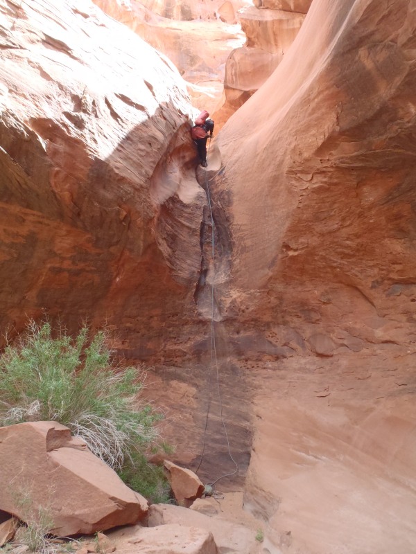
Abby is on the last rappel of Morocco in May of 2010. This is what the rap looks like with no water flow.
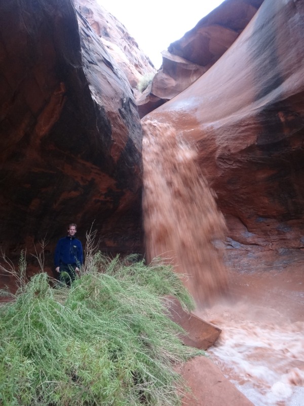
Here is Luke standing near the bottom of the final rappel in
Morocco Canyon during a medium rain storm in September of 2011.
This is what the final rappel looks like when the area gets some
rain.
As a side note, Dave looked up the precip records for Hanksville
Utah which is about 20 miles from here. On the day of this
picture (09-17-11)
www.weather.com shows 0.09 inches of rain fall in Hanksville.
The day before shows 0.37 inches of rain in Hanksville.
Imagine what this rappel would look like with over 3 times this
amount of water! This helps put the idea of flash flood
danger a little more in perspective.
Downloadable GPX files
available at
BG-Gear Store
(easier than manual entry and a great way to support
Bluugnome).
Waypoint naming convention and map symbol information can be found on the Glossary page.
Elevations are approximate.
BEFORE
manually entering coordinates set your system to WGS84 datum and Lat/Lon hddd.ddddd° coordinate format.
Inconsistent datum's and coordinate formats will result in location errors.
Click to show / expand the list of waypoints below........
| Morocco (1) - Approach |
- pkCasablanca
Lat/Lon (WGS84): N 37.97727
W -110.49158
Elev: 4,155 Feet
Parking for Casablanca Canyon. Also where you park to start the route up to Morocco Canyon.
- wMoroccoRP-01
Lat/Lon (WGS84): N 37.97679
W -110.49075
Elev: NaN Feet
Bowl shaped indent in the side of the mountain at its base. This is where you start the climb up.
- wMoroccoRP-02
Lat/Lon (WGS84): N 37.97586
W -110.48993
Elev: NaN Feet
On top of the highest of the two ledges. you are now about level with the top of the prominent rock face. Traverse along the ledge to the top of the rock face.
- wMoroccoRP-03
Lat/Lon (WGS84): N 37.97511
W -110.49057
Elev: NaN Feet
On top of the rock face. The route from here is pretty level over all.
- wMoroccoRP-04
Lat/Lon (WGS84): N 37.97411
W -110.48843
Elev: NaN Feet
Rock debris ends and you are on slick rock. There is a ledge about 20 feet down and closer to the rime. Stay high and do not drop down to the lower ledge.
- yMoroccoTp
Lat/Lon (WGS84): N 37.97478
W -110.48725
Elev: 4,385 Feet
Top entry for Morocco Canyon. This is also rap 1 for the canyon and is at the top of a deep kind of narrow slot. Rap 1 is anchored from a cairn anchor and drops about 45 feet down into the narrow slot.
|
| Morocco (2) - The Canyon and Exit |
- yMoroccoTp
Lat/Lon (WGS84): N 37.97478
W -110.48725
Elev: 4,385 Feet
Top entry for Morocco Canyon. This is also rap 1 for the canyon and is at the top of a deep kind of narrow slot. Rap 1 is anchored from a cairn anchor and drops about 45 feet down into the narrow slot.
- dMoroccoR2
Lat/Lon (WGS84): N 37.97450
W -110.48737
Elev: 4,344 Feet
Rap 2 - Morocco. Anchored from a large choke stone overhead in a tight slot and drops about 35 feet to a ledge with a little free hang along the way.
- dMoroccoR3
Lat/Lon (WGS84): N 37.97372
W -110.48808
Elev: NaN Feet
Rap 3 - Morocco. Anchored from choke stone embedded in wash and drops about 20 feet. It is possible to down climb this rap.
- wMoroccoRP-05
Lat/Lon (WGS84): N 37.97342
W -110.48871
Elev: NaN Feet
Two pools of water below down climbs. Each can be stemmed over or bypassed high RDC.
- dMoroccoR4-5
Lat/Lon (WGS84): N 37.97345
W -110.48920
Elev: 4,278 Feet
Raps 4 and 5 - Morocco.
Rap 4 anchored from cairn anchor and drops about 20 feet to a pool.
Rap 5 anchor from choke stone RDC and drops about 15 feet.
- dMoroccoR6
Lat/Lon (WGS84): N 37.97327
W -110.49025
Elev: NaN Feet
Rap 6 - Morocco. Anchored from small choke stones placed in the water course and drops about 30 feet.
- yMoroccoBt
Lat/Lon (WGS84): N 37.97323
W -110.49129
Elev: 4,140 Feet
Bottom exit of Morocco Canyon where it meets highway 95 on the north side of a drainage tunnel under the road.
- pkCasablanca
Lat/Lon (WGS84): N 37.97727
W -110.49158
Elev: 4,155 Feet
Parking for Casablanca Canyon. Also where you park to start the route up to Morocco Canyon.
|