Canyoneering Route Description
Secret Canyon - 3A II(III)
Lake Mead Nat. Rec. Area, Arizona.
12-14-13, 8 people, 1 Day (Travel time in route 5 hours)
 Exit option 2 and spend time soaking in hot pools.
02-09-19, 3 people, 1
Day (Travel time in route 5.5 hours) Exit option 1 and explored
drainages south.
Time Required - 3 to 4 hours
Distance for exit option one - 2.6 miles Total,
0.2 miles Technical
Distance for exit option two - 3.0 miles Total,
0.2 miles Technical
Rappels - 2 Rappels, Longest Rappel 70 feet.
Elevation Range - 680 - 1310 Feet
Shuttle Required - No Vehicle - Passenger
Permit Required - No
Rappelling and anchor gear, Ropes and or pull cords for rappels up
to 70 feet and 20 feet of 1 inch webbing for sling placement.
Ascenders and the knowledge to use them. Most people will want
to use exit option 1.
Secret Canyon is on the Arizona side of the Colorado
River but the closest city area is Boulder City, Henderson, Las Vegas Area.
Secret canyon is a good half day fun route with minimal
technical commitment but does require ascending out of the canyon. The
majority of the route is through easy to travel desert washes. The technical
section is about 1200 feet long.
The last 100 or 150 feet might have hot springs water
flowing or may not. In that last section of canyon what you find can
differ depending on what happens to this area. You may find easy scrambles
all the way out to the river or you may find a couple pools of water (some
hot some cold). On our visit in 2013 the gravel had been washed out (or
maybe dug out by someone) where we had an enjoyable soak in a deep pool of
hot water worth relaxing in for quite some time. Just down canyon was a
large very cold pool of river water we had to swim to get out to where we
could get to the river. On our return in 2019, gravel had filled in the
pools leaving an easy walk over everything we had seen in the past making
access to the river a casual stroll but no hot pools to enjoy.
While there are some downclimbs on the first part of
the approach, I do not label the approach as technical. Even though some
people may need a rope for one of the downclimbs, the whole section is
optional as you can simply follow the exit route to bypass the downclimb
entry option. See the map for a better idea.
There are two exit options for the lower portion of
Secret Canyon.
Exit option 1 is to leave ropes fixed at
both anchors and ascend back up the ropes. If using this exit option, be
sure to evaluate any downclimbs you go down to be sure you can get back up
them to the ropes you intend to ascend. Ascending the ropes for this
exit option is a lot easier than exit option 2 and most people will prefer
exit option 1.
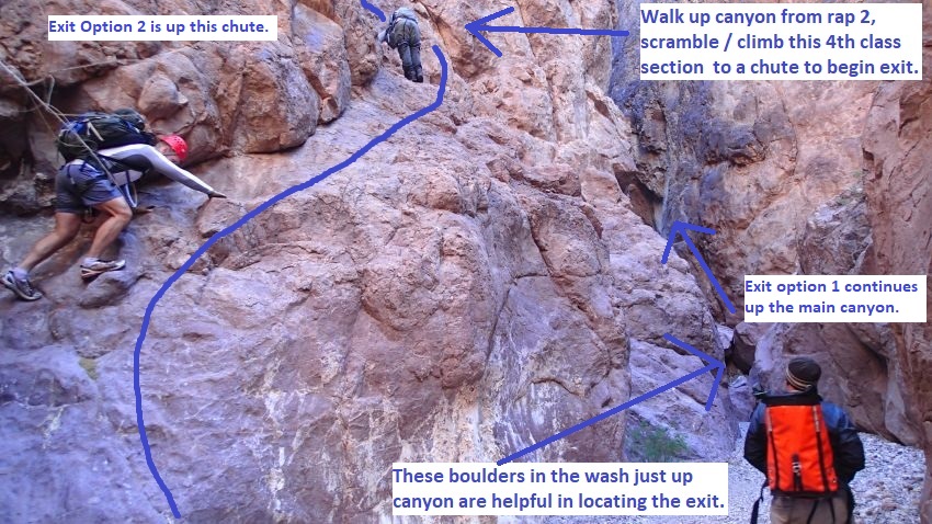
Exit option 2 is to ascend up rap 2
(or bypass rap 2 by scrambling around it) then scramble up a chute between
raps 1 and 2 to exit the canyon then follow VERY rugged terrain and steep
scree slopes up to an old road that winds its way back down into the upper
wash of Secret Canyon. Portions of this exit are rugged and steep, so care
must be taken to travel safely. The old road on exit option 2 has some
equipment and foundations to look at which may be of interest to those who
like such things.
Both exit options rejoin in the wash above the
technical section where you then follow part way up the main wash to a side
wash which is then followed out to avoid the need to upclimb the original
approach.
Thanks to Rick Ianniello for publishing this route.
This and other routes in the area can be found in his book "Las Vegas
Slots".
To get to the Trailhead
From Boulder City, Nevada, drive south on Highway 93 towards
Hoover Dam. After crossing Hoover Dam into Arizona, take Exit 2
(Kingman Wash Road). Turn right then immediately turn right
again to drive north on the frontage road. Drive the frontage
road for about 400 feet to a huge dirt parking area on the left
(west) side of the road (tKingmanWash) and park there.
To leave the Exit Vehicle / Escape Pod
No exit vehicle is needed. This is done as a loop route.
GPS coordinate information listed at the bottom. For information about waypoint naming and map symbols, refer to the
Glossary page.

Click the links for maps of the route.
Map of the entire route.
Map of the technical section.
Map overview with route arrows and options.
The Approach:
From the parking spot (tKingmanWash)
walk southwest down the
gravel slope about 30
feet then turn left and
walk south about 200
feet to where a tunnel
travels under the road.
Where the tunnel travels
under the road
(Secret01), follow the
wash leading down to the
south then west away
from the tunnel.
About 450 feet farther a
minor wash drops in
(Secret02) from the left
(south). Continue down
the wash west then
northwest.
About 200 feet farther
the dirt bank on the LDC
(west) side is only
about 10 feet tall
(Secret03) and is where
the exit route will drop
back into this wash.
On the way in to Secret
Canyon, continue north
down the wash.
About 400 feet farther
is a series of easy
scramble / downclimbs
(Secret04). The 4th one
is about 15 feet.
About 400 feet farther
is a moderately
difficult downclimb
(Secret05) of about 15
feet. Optionally can
rappel from a bolted
hanger on the LDC side.
About 120 feet farther
is a short easy
downclimb (Secret06) to
get down to a pool to
straddle over. This is
just before the canyon
opens up to wide wash.
About 450 feet farther
is a downclimb
(Secret07) of about 6
feet followed by a walk
thorough narrow slot of
almost 400 feet long.
About 500 feet farther
is a side drainage
(Secret08) drops in from
the right (north) about
100 feet after exiting
the walkthrough slot.
About 900 feet farther
is a confluence where
two washes join
(Secret09Jct).
To
continue down to Secret
Canyon, follow the wash
west downstream.
Remember this spot since
you will be going up the
wash to the south on
your exit from Secret
Canyon.
Shortly down canyon is
the start of (Secret10)
another narrows and a
series of short easy
downclimbs.
About 0.2 miles farther
an old road drops down
to the wash
(Secret11Jct) on the RDC
(north) side but may go
un-noticed if you are
not looking for it.
If you choose exit
option 2, that old road
is what you will be on
to get back to the wash.
Continue down the main
wash to Secret Canyon.
About 750 feet farther
is a scrambling section
(Secret12) to an easy
downclimb of about 6
feet then a walk through
slot about 80 feet long.
About 1000 feet farther
is the top entry of
Secret Canyon (ySecretTp).
This is where the canyon
gets deeper and begins
to close in more
consistently.
The Canyoneering / Technical Section:
Shortly into the
entry narrows (ySecretTp)
are 2 downclimbs of
about 4 feet each
followed by a 12 foot
slightly sloped
downclimb.
Note/Warning:
Be sure to
evaluate this 12 foot
drop to see if you can
climb back up it. If you
intend to exit out of
Secret Canyon by
ascending back up the
raps, you will also need
to get back up this
drop. The upclimb is
moderately challenging
and may be difficult for
those not used to
upclimbing.
About 300 feet farther a
side drainage joins
(Secret13) in on the RDC
(north) side at the apex
of a sharp left hand
bend as the walls widen
to more open wash.
About 275 feet farther
is a wide ravine
(Secret14) going up out
of the wash on the RDC
(north) side.
Continue down the main
wash.
About 200 feet farther
is rap 1.
Rap 1 (dSecretR1) is
anchored LDC from 2
bolted hangers and drops
alongside a huge
overhanging boulder and
drops about 70 feet down
a smooth vertical wall.
Down canyon of rap 1 are
a couple of short
downclimbs over boulders
before reaching rap 2.
Between raps 1 and 2 are
some boulders to
downclimb through.
About 45 feet down
canyon of those boulders
is a side chute
(Secret15) going steeply
up out of the wash on
the RDC (north) side.
That chute is what you
would climb up if you
decide on exit option 2.
Continue down the main
wash about 100 feet to
go to rap 2.
Rap 2 (dSecretR2) is
anchored RDC from a
single bolted hanger and
2 very large very old
eye bolts and drops
about 25 feet down into
warm spring water.
Optionally you can
bypass by downclimbing
along the ledges on the
RDC (north) side. The
ledges on the RDC side
are intimidating looking
from the top and can be
tricky. However, the
ledges are much easier
to climb coming back up.
The suggestion is to
rappel down and scramble
the ledges back up.
After rap 2 are a few
short downclimbs through
hot springs water
eventually leading to
the Colorado River.
Note:
Depending on what
happens to this area you
may find easy scrambles
all the way out to the
river or you may find a
couple pools of water
(some hot some cold). On
our visit in 2013 the
gravel had been washed
out (or maybe dug out by
someone) where we had an
enjoyable soak in a deep
pool of hot water
(Secret16) worth
relaxing in for quite
some time. Just down
canyon was a large very
cold pool of river water
we had to swim to get
out to where we could
get to the river. On our
return in 2019, gravel
had filled in the pools
leaving an easy walk
over everything we had
seen in the past making
access to the river a
casual stroll.
When you get to the
Colorado River, you have
reached the end of the
canyon (ySecretBt).
The Exit:
From the
end of the canyon (ySecretBt)
turn around and go back
up canyon to rap 2.
Upclimb the ledges on
the north side wall to
bypass to the top of rap
2 (dSecretR2). The
ledges are easier to
scramble on the way up
will likely be easier
than trying to ascend a
fixed rope.
About 100 feet up canyon
of rap 2 and about 45
feet down canyon of some
boulders is a steep
chute on the LUC (north)
side. This is
where you decide to use
exit option 1 or exit
option 2.
 To use exit option 2
upclimb the steep chute.
To use exit option 2
upclimb the steep chute.
To use exit option 1
continue up the main
wash to the bottom of
rap 1.
Exit Option 1:
Re-ascend the canyon
Continue up the
main canyon to the
bottom of rap 1.
Ascend the rope you left
at the anchors for rap
1. You did bring
ascending gear right?
Once at the top of rap 1
(dSecretR1) continue up
the main canyon about
700 feet to the head of
the canyon (ySecretTp).
Continue up the main
wash for about 0.6 miles
to the wide wash joining
in on the RUC (south)
side (Secret09Jct).
This is the large wash
that will be followed
out instead of going up
the main wash you came
in on during the
approach.
Scroll down to the
continuation of the
exit....
Exit Option 2:
Rugged optional route
Climb up the steep chute
(Secret15) starting with
a class 4 scramble of
about 15 feet to get up
into the chute. The
chute then offers easy
scrambling up from
there.
About 350 feet farther
the Chute tops out
(Secret17). Route find
your way north over to
where you can begin to
drop down the slope
farther north. The
terrain is steep and
rugged, so be careful
not to slip.
About 130 feet farther
drop down the slope
(Secret18) and route
find your way along
various ledges and north
toward a scree slope
with a lot of metal junk
strung all over it. As
you get closer to the
scree slope, stay high
to follow a series of
ledges with a couple
sketchy spots to
traverse.
About 300 feet farther
you will be on the scree
pile (Secret19), turn
right (east) and work
your way up the steep
loose scree slope. Go a
little over 100 feet up
the scree slope to a
small saddle. Lots of
old junk here to enjoy
looking at.
From the small saddle
(Secret20) turn right
(southeast) to leave the
scree slope and scramble
your way up a ravine to
avoid the very steep,
very loose upper
portions of the scree
slope above.
At the top of the ravine
is a saddle (Secret21),
turn left (east) and go
up a short section of
class 4 scrambling to
get onto a ridge. Then
veer left and follow the
ridge almost 400 feet
northeast up to a large
flat area.
The large flat area
(Secret22) is the end of
an old road. Walk
north and follow an old
graded road.
About 0.25 miles farther
the road makes a sharp
bend (Secret23) to the
right (southeast).
About 700 feet farther
the road tops out
(Secret24). Follow it
southeast as it begins
to drop down to Secret
Canyon upper wash.
About 0.25 miles farther
the old road drops into
the main wash
(Secret11Jct).
Turn left and follow up
the wash to the
northeast.
About 1000 feet up the
main wash is a wide wash
joining in on the RUC
(south) side
(Secret09Jct). This is
the large wash that will
be followed out instead
of going up the main
wash you came in on
during the approach.
Scroll down to the
continuation of the
exit....
Continuation of
Exit after options 1 or
2:
From the large wash
joining in on the RUC
(south) side
(Secret09Jct) follow up
the wash going up to the
south.
About 0.22 miles up the
wash is an old road
easily missed
(Secret25). Leave
the wash on the LUC
(north) side and travel
east up the old road.
The road is right at the
up canyon end of a
section of yellow rock.
Note:
The road may be
overlooked but the very
prominent yellow rock
section is a very good
landmark. Leave the wash
and go up to the old
road where you will find
some of the pavement in
good shape. Follow the
road up to the east.
About 900 feet farther
is a saddle where the
old road tops out
(Secret26). Follow the
old road east about 175
feet down to the wash
used for the approach.
Once back in the main
wash used for the
approach (Secret03) turn
right and walk south
then west reversing the
approach route about 0.2
miles back to the cars (tKingmanWash).
Downloadable GPX files
available at
BG-Gear Store
(easier than manual entry and a great way to support
Bluugnome).
Waypoint naming convention and map symbol information can be found on the Glossary page.
Elevations are approximate.
BEFORE
manually entering coordinates set your system to WGS84 datum and Lat/Lon hddd.ddddd° coordinate format.
Inconsistent datum's and coordinate formats will result in location errors.
Click to show / expand the list of waypoints below........
| Secret Canyon (1) - Approach |
- tKingmanWash
Lat/Lon (WGS84): N 36.00255
W -114.72436
Elev: 1,310 Feet
Kingman Wash Trailhead with a huge dirt parking area. To go to Secret Canyon walk southwest down the gravel slope about 30 feet then turn left and walk south about 200 feet to where a tunnel travels under the road.
- Secret01
Lat/Lon (WGS84): N 36.00207
W -114.72417
Elev: NaN Feet
Tunnel travels under the road. Travel the wash leading down to the south then west away from the tunnel.
- Secret02
Lat/Lon (WGS84): N 36.00161
W -114.72522
Elev: NaN Feet
Minor wash drops in from the left (south). Continue down the wash west then northwest.
- Secret03
Lat/Lon (WGS84): N 36.00198
W -114.72557
Elev: NaN Feet
The dirt bank on the LDC (west) side is only about 10 feet tall and is where the exit route will drop back into this wash.
On the way in to Secret Canyon, continue north down the wash.
On the exit out from Secret Canyon, drop down the dirt bank into the wash, turn right and walk south then west reversing the approach route back to the cars.
- Secret04
Lat/Lon (WGS84): N 36.00300
W -114.72603
Elev: NaN Feet
Series of easy scramble / downclimbs. The 4th one is about 15 feet.
- Secret05
Lat/Lon (WGS84): N 36.00392
W -114.72630
Elev: NaN Feet
Moderately difficult downclimb of about 15 feet. Optionally can rappel from a bolted hanger on the LDC side.
- Secret06
Lat/Lon (WGS84): N 36.00422
W -114.72650
Elev: NaN Feet
Short easy downclimb to get down to a pool to stradle over. This is just before the canyon opens up to wide wash.
- Secret07
Lat/Lon (WGS84): N 36.00460
W -114.72765
Elev: NaN Feet
Downclimb of about 6 feet followed by a walk thorough narrow slot of almost 400 feet long.
- Secret08
Lat/Lon (WGS84): N 36.00464
W -114.72916
Elev: NaN Feet
Side drainage drops in from the right (north) about 100 feet after exiting the walkthrough slot.
- Secret09Jct
Lat/Lon (WGS84): N 36.00384
W -114.73210
Elev: 1,030 Feet
Confluence where two washes join.
To continue down to Secret Canyon, follow the wash west downstream.
To exit out from Secret Canyon follow up the wash going up to the south.
- Secret10
Lat/Lon (WGS84): N 36.00379
W -114.73254
Elev: NaN Feet
Start of another narrows and a series of short easy downclimbs.
- Secret11Jct
Lat/Lon (WGS84): N 36.00296
W -114.73535
Elev: NaN Feet
Bottom end of an old road dropping down from the north side.
To continue down to Secret Canyon, continue west down the wash.
To exit out from Secret Canyon follow up the wash to the northeast.
- Secret12
Lat/Lon (WGS84): N 36.00194
W -114.73674
Elev: NaN Feet
Scrambling section to an easy downclimb of about 6 feet then a walk through slot about 80 feet long.
- ySecretTp
Lat/Lon (WGS84): N 35.99983
W -114.73781
Elev: 890 Feet
Top entry of Secret Canyon. This is where the canyon gets deeper and begins to close in more consistently. Shortly into this narrows are 2 downclimbs of about 4 feet each followed by a 12 foot slightly sloped downclimb.
Note/Warning: Be sure to evaluate this 12 foot drop to see if you can climb back up it. If you intend to exit out of Secret Canyon by ascending back up the raps, you will also need to get back up this drop. The upclimb is moderately challenging and may be difficult for those not used to upclimbing.
Note: There are cairns marking a route up out of the wash on the LDC (south) side. Following those cairns leads up to well used animal trails that can be followed south over to other drainages.
|
| Secret Canyon (2) - The Canyon |
- ySecretTp
Lat/Lon (WGS84): N 35.99983
W -114.73781
Elev: 890 Feet
Top entry of Secret Canyon. This is where the canyon gets deeper and begins to close in more consistently. Shortly into this narrows are 2 downclimbs of about 4 feet each followed by a 12 foot slightly sloped downclimb.
Note/Warning: Be sure to evaluate this 12 foot drop to see if you can climb back up it. If you intend to exit out of Secret Canyon by ascending back up the raps, you will also need to get back up this drop. The upclimb is moderately challenging and may be difficult for those not used to upclimbing.
Note: There are cairns marking a route up out of the wash on the LDC (south) side. Following those cairns leads up to well used animal trails that can be followed south over to other drainages.
- Secret13
Lat/Lon (WGS84): N 36.00021
W -114.73848
Elev: NaN Feet
Side drainage joins in on the RDC (north) side at the apex of a sharp left hand bend as the walls widen to more open wash.
- Secret14
Lat/Lon (WGS84): N 35.99975
W -114.73914
Elev: NaN Feet
Wide ravine going up out of the wash on the RDC (north) side.
- dSecretR1
Lat/Lon (WGS84): N 35.99931
W -114.73952
Elev: NaN Feet
Rap 1 - Secret Canyon. Anchored LDC from 2 bolted hangers and drops alongside a huge overhanging boulder and drops about 70 feet down a smooth vertical wall. Down canyon of rap 1 are a couple of short downclimbs over boulders before reaching rap 2.
- Secret15
Lat/Lon (WGS84): N 35.99943
W -114.73996
Elev: NaN Feet
Chute on the RDC (north) side that can be used an an alternate exit. The chute is about 45 feet down canyon of some boulders to scramble over and about 100 feet up canyon of rap 2.
Navigation Aid, Alternate Exit: If following the alternate exit from Secret Canyon you will need to go up the chute starting with a class 4 scramble of about 15 feet to get up into the chute. The chute then offers easy scrambling up from there.
- dSecretR2
Lat/Lon (WGS84): N 35.99953
W -114.74028
Elev: NaN Feet
Rap 2 - Secret Canyon, anchored RDC from a single bolted hanger and 2 very large very old eye bolts and drops about 25 feet down into warm spring water. Optionally you can bypass by downclimbing along the ledges on the RDC (north) side. The ledges on the RDC side are intimidating looking from the top and can be tricky. However, the ledges are much easier to climb coming back up. The suggestion is to rappel down and scramble the ledges back up.
- Secret16
Lat/Lon (WGS84): N 35.99943
W -114.74049
Elev: NaN Feet
After rap 2 are a few short downclimbs through hot springs water eventually leading to the Colorado River.
Note: Depending on what happens to this area you may find easy scrambles all the way out to the river or you may find a couple pools of water (some hot some cold). On our visit in 2013 the gravel had been washed out (or maybe dug out by someone) where we had an enjoyable soak in a deep pool of hot water worth relaxing in for quite some time. Just down canyon was a large very cold pool of river water we had to swim to get out to where we could get to the river. On our return in 2019, gravel had filled in the pools leaving an easy walk over everything we had seen in the past making access to the river a casual stroll.
- ySecretBt
Lat/Lon (WGS84): N 35.99922
W -114.74081
Elev: 685 Feet
Bottom of Secret canyon where it dumps out into Black Canyon and the Colorado River.
|
| Secret Canyon (3) - Exit Option 1 |
- ySecretBt
Lat/Lon (WGS84): N 35.99922
W -114.74081
Elev: 685 Feet
Bottom of Secret canyon where it dumps out into Black Canyon and the Colorado River.
- dSecretR2
Lat/Lon (WGS84): N 35.99953
W -114.74028
Elev: NaN Feet
Rap 2 - Secret Canyon, anchored RDC from a single bolted hanger and 2 very large very old eye bolts and drops about 25 feet down into warm spring water. Optionally you can bypass by downclimbing along the ledges on the RDC (north) side. The ledges on the RDC side are intimidating looking from the top and can be tricky. However, the ledges are much easier to climb coming back up. The suggestion is to rappel down and scramble the ledges back up.
- Secret15
Lat/Lon (WGS84): N 35.99943
W -114.73996
Elev: NaN Feet
Chute on the RDC (north) side that can be used an an alternate exit. The chute is about 45 feet down canyon of some boulders to scramble over and about 100 feet up canyon of rap 2.
Navigation Aid, Alternate Exit: If following the alternate exit from Secret Canyon you will need to go up the chute starting with a class 4 scramble of about 15 feet to get up into the chute. The chute then offers easy scrambling up from there.
- dSecretR1
Lat/Lon (WGS84): N 35.99931
W -114.73952
Elev: NaN Feet
Rap 1 - Secret Canyon. Anchored LDC from 2 bolted hangers and drops alongside a huge overhanging boulder and drops about 70 feet down a smooth vertical wall. Down canyon of rap 1 are a couple of short downclimbs over boulders before reaching rap 2.
- Secret14
Lat/Lon (WGS84): N 35.99975
W -114.73914
Elev: NaN Feet
Wide ravine going up out of the wash on the RDC (north) side.
- Secret13
Lat/Lon (WGS84): N 36.00021
W -114.73848
Elev: NaN Feet
Side drainage joins in on the RDC (north) side at the apex of a sharp left hand bend as the walls widen to more open wash.
- ySecretTp
Lat/Lon (WGS84): N 35.99983
W -114.73781
Elev: 890 Feet
Top entry of Secret Canyon. This is where the canyon gets deeper and begins to close in more consistently. Shortly into this narrows are 2 downclimbs of about 4 feet each followed by a 12 foot slightly sloped downclimb.
Note/Warning: Be sure to evaluate this 12 foot drop to see if you can climb back up it. If you intend to exit out of Secret Canyon by ascending back up the raps, you will also need to get back up this drop. The upclimb is moderately challenging and may be difficult for those not used to upclimbing.
Note: There are cairns marking a route up out of the wash on the LDC (south) side. Following those cairns leads up to well used animal trails that can be followed south over to other drainages.
- Secret12
Lat/Lon (WGS84): N 36.00194
W -114.73674
Elev: NaN Feet
Scrambling section to an easy downclimb of about 6 feet then a walk through slot about 80 feet long.
- Secret11Jct
Lat/Lon (WGS84): N 36.00296
W -114.73535
Elev: NaN Feet
Bottom end of an old road dropping down from the north side.
To continue down to Secret Canyon, continue west down the wash.
To exit out from Secret Canyon follow up the wash to the northeast.
- Secret10
Lat/Lon (WGS84): N 36.00379
W -114.73254
Elev: NaN Feet
Start of another narrows and a series of short easy downclimbs.
- Secret09Jct
Lat/Lon (WGS84): N 36.00384
W -114.73210
Elev: 1,030 Feet
Confluence where two washes join.
To continue down to Secret Canyon, follow the wash west downstream.
To exit out from Secret Canyon follow up the wash going up to the south.
|
| Secret Canyon (4) - Exit Option 2 |
- ySecretBt
Lat/Lon (WGS84): N 35.99922
W -114.74081
Elev: 685 Feet
Bottom of Secret canyon where it dumps out into Black Canyon and the Colorado River.
- Secret16
Lat/Lon (WGS84): N 35.99943
W -114.74049
Elev: NaN Feet
After rap 2 are a few short downclimbs through hot springs water eventually leading to the Colorado River.
Note: Depending on what happens to this area you may find easy scrambles all the way out to the river or you may find a couple pools of water (some hot some cold). On our visit in 2013 the gravel had been washed out (or maybe dug out by someone) where we had an enjoyable soak in a deep pool of hot water worth relaxing in for quite some time. Just down canyon was a large very cold pool of river water we had to swim to get out to where we could get to the river. On our return in 2019, gravel had filled in the pools leaving an easy walk over everything we had seen in the past making access to the river a casual stroll.
- dSecretR2
Lat/Lon (WGS84): N 35.99953
W -114.74028
Elev: NaN Feet
Rap 2 - Secret Canyon, anchored RDC from a single bolted hanger and 2 very large very old eye bolts and drops about 25 feet down into warm spring water. Optionally you can bypass by downclimbing along the ledges on the RDC (north) side. The ledges on the RDC side are intimidating looking from the top and can be tricky. However, the ledges are much easier to climb coming back up. The suggestion is to rappel down and scramble the ledges back up.
- Secret15
Lat/Lon (WGS84): N 35.99943
W -114.73996
Elev: NaN Feet
Chute on the RDC (north) side that can be used an an alternate exit. The chute is about 45 feet down canyon of some boulders to scramble over and about 100 feet up canyon of rap 2.
Navigation Aid, Alternate Exit: If following the alternate exit from Secret Canyon you will need to go up the chute starting with a class 4 scramble of about 15 feet to get up into the chute. The chute then offers easy scrambling up from there.
- Secret17
Lat/Lon (WGS84): N 36.00031
W -114.74048
Elev: NaN Feet
Chute tops out. Route find your way north over to where you can begin to drop down the slope farther north. The terrain is steep and rugged, so be careful not to slip.
- Secret18
Lat/Lon (WGS84): N 36.00066
W -114.74061
Elev: NaN Feet
Drop down the slope and route find your way along various ledges and north toward a scree slope with a lot of metal junk strung all over it. As you get closer to the scree slope, stay high to follow a series of ledges with a couple sketchy spots to traverse.
- Secret19
Lat/Lon (WGS84): N 36.00146
W -114.74061
Elev: NaN Feet
Once on the steep scree pile, turn right (east) and work your way up the steep loose scree slope. Go a little over 100 feet up the scree slope to a small saddle. Lots of old junk here to enjoy looking at.
- Secret20
Lat/Lon (WGS84): N 36.00162
W -114.74028
Elev: NaN Feet
Small saddle part way up the scree slope, Turn right (southeast) to leave the scree slope and scramble your way up a ravine to avoid the very steep, very loose upper portions of the scree slope above.
- Secret21
Lat/Lon (WGS84): N 36.00090
W -114.73994
Elev: NaN Feet
Saddle at the top of the ravine. Turn left (east) and go up a short section of class 4 scrambling to get onto a ridge. Then veer left and follow the ridge almost 400 feet northeast up to a large flat area.
- Secret22
Lat/Lon (WGS84): N 36.00184
W -114.73929
Elev: 1,065 Feet
Up on large flat graded area. Walk north and follow an old graded road.
- Secret23
Lat/Lon (WGS84): N 36.00522
W -114.74028
Elev: NaN Feet
Road makes a sharp bend to the right (southeast).
- Secret24
Lat/Lon (WGS84): N 36.00372
W -114.73884
Elev: NaN Feet
Road tops out. Follow it southeast as it begins to drop down to Secret Canyon upper wash.
- Secret11Jct
Lat/Lon (WGS84): N 36.00296
W -114.73535
Elev: NaN Feet
Bottom end of an old road dropping down from the north side.
To continue down to Secret Canyon, continue west down the wash.
To exit out from Secret Canyon follow up the wash to the northeast.
- Secret10
Lat/Lon (WGS84): N 36.00379
W -114.73254
Elev: NaN Feet
Start of another narrows and a series of short easy downclimbs.
- Secret09Jct
Lat/Lon (WGS84): N 36.00384
W -114.73210
Elev: 1,030 Feet
Confluence where two washes join.
To continue down to Secret Canyon, follow the wash west downstream.
To exit out from Secret Canyon follow up the wash going up to the south.
|
| Secret Canyon (5) - Continuation of Exit |
- Secret09Jct
Lat/Lon (WGS84): N 36.00384
W -114.73210
Elev: 1,030 Feet
Confluence where two washes join.
To continue down to Secret Canyon, follow the wash west downstream.
To exit out from Secret Canyon follow up the wash going up to the south.
- Secret25
Lat/Lon (WGS84): N 36.00190
W -114.72940
Elev: NaN Feet
Old road easily missed. Leave the wash on the LUC (north) side and travel east up the old road. The road is right at the up canyon end of a section of yellow rock. The road may be overlooked but the very prominent yellow rock section is a very good landmark. Leave the wash and go up to the old road where you will find some of the pavement in good shape. Follow the road up to the east.
- Secret26
Lat/Lon (WGS84): N 36.00195
W -114.72617
Elev: 1,290 Feet
Saddle where the old road tops out. Follow the old road east about 175 feet down to the wash used for the approach.
- Secret03
Lat/Lon (WGS84): N 36.00198
W -114.72557
Elev: NaN Feet
The dirt bank on the LDC (west) side is only about 10 feet tall and is where the exit route will drop back into this wash.
On the way in to Secret Canyon, continue north down the wash.
On the exit out from Secret Canyon, drop down the dirt bank into the wash, turn right and walk south then west reversing the approach route back to the cars.
- Secret02
Lat/Lon (WGS84): N 36.00161
W -114.72522
Elev: NaN Feet
Minor wash drops in from the left (south). Continue down the wash west then northwest.
- Secret01
Lat/Lon (WGS84): N 36.00207
W -114.72417
Elev: NaN Feet
Tunnel travels under the road. Travel the wash leading down to the south then west away from the tunnel.
- tKingmanWash
Lat/Lon (WGS84): N 36.00255
W -114.72436
Elev: 1,310 Feet
Kingman Wash Trailhead with a huge dirt parking area. To go to Secret Canyon walk southwest down the gravel slope about 30 feet then turn left and walk south about 200 feet to where a tunnel travels under the road.
|