Canyoneering Route Description
Devils Drain Canyon - 3B IV
Lake Mead Nat. Rec. Area, Nevada.
12-21-12, 15 people and one dog, 2 Day (Travel time in route 8.5 hours)
 Packraft exit down river then hike out AZ side.
Time Required - 7 to 10 hours (not including
vehicle shuttle time)
Distance - 7.7 miles Total, 1.4 miles Technical
(0.8 miles of the route is packrafting)
Rappels - 4 Rappels, Longest Rappel 140 feet.
Elevation Range - 650 - 2400 Feet
Shuttle Required - Yes 19.3 Miles Vehicle -
Passenger
Permit Required - No
Rappelling and anchor gear, Ropes and or pull cords for rappels up
to 140 feet and 60 feet of 1 inch webbing for sling placement.
To packraft the river you will need a raft and you a life jacket is
REQUIRED to legally float down the river. Wet suits are
recommended when rafting the river since the water is about 50
degrees year round. The wet suits are not needed in the canyon
itself.
Devils Drain Canyon drops down into the Nevada side of
Colorado River in the Black Canyon area in the Lake Mead National Recreation
area. Devils Drain Canyon offers a fun and scenic rappel through a large
arch, the enjoyment of traveling through hot springs while in canyon and a peak
at the Colorado River in the Black Canyon area.
This route gives a lot of variety. You will start
the route on the Nevada side of the Colorado River, descend Devils Drain
Canyon (including a rappel through a hole in the top of a natural bridge),
packraft about 0.75 miles down stream in the Colorado River and cross to the
other side then hike about 3 miles out to your exit vehicle parked on the
Arizona side on Highway 93. In Devils Drain Canyon you will also hike
through hotsprings. On the hike out the other side of the river you
will have another opportunity to enjoy the Arizona Hot Springs (Ring Bolt
Hot Springs) as well.
Thanks to Rick Ianniello for sharing this route.
It was one of the highlights of my End of the World Birthday party in 2012!
You remember 2012 when the world was predicted to end but kept right on
going after the 21st of December.
So far I have only done a packraft exit for Devils
Drain Canyon. You do need a packraft to complete this route as
described.
After the end of Devils Drain Canyon you will packraft
down stream about 0.75 miles in the Colorado River to a beach on the
opposite side of the river. From that beach you will hike out to
Highway 93 on the Arizona side of the river. The exit route described
here for the hike up from the Arizona Hot Springs is the shortest option.
WARNING - There is one turn on that exit route that is VERY
DIFFICULT TO FIND IN THE DARK. If you are not familiar with the area
and think you will be exiting in the dark, BRING A GPS to help locate the
proper spot to turn.
To get to the Trailhead
Driving East into Boulder City Nevada on highway 93 driver to
the stop light for the intersection of highway 93 and Buchanan
Blvd. Turn right (south) onto Buchanan Blvd and drive 0.4
miles to the intersection of Buchanan Blvd and Adams Blvd.
Turn left (east) onto Adams Blvd and drive 1.33 miles to the
intersection of Adams Blvd and Utah Street (extUtah-Adams). Turn
right (southeast) onto Utah Street.
Note:
Once you are on Utah Street headed southeast away from the main
part of Boulder City there will be a lot of dirt roads going in
different directions. It may be easy to get a little lost
out there. Pay close attention to the directions and you
should easily get where you need to be.
About 0.62 miles down Utah Street will be a dirt road joining in
(extMtrcyclAlt) from the left (northeast). Continue
southeast on Utah Street passing the dirt road.
About 0.2 miles farther is another paved road joining in (extUtah-CnynPt)
from the right (south). This is Canyon Point Road and will
lead you where you need to go. Turn right (south) onto
Canyon Point Road.
Drive 0.9 miles southeast on Canyon Point Road to a sharp bend to
the left (extLkMdRoad58). At this bend is where you will
leave the pavement. The pavement turns to the left to go
north but Canyon Point Road continues southeast but becomes
dirt. Leave the paved road and continue southeast onto the
dirt road ahead.
Note:
This dirt portion of Canyon Point Road is part of the Lake Mead
Nat. Rec. Area Backcountry Road System and is road 58 in that
system. If you are looking at a map with the Lake Mead
Backcountry Roads on it, Canyon Point Road is Road 58.
About 500 feet down the dirt road is a fork in the road
(wRaod58DP-01). Stay right at the fork and continue
southeast.
About 0.25 miles farther is another fork (wRaod58DP-02).
Also stay right at this fork to continue southeast.
After this fork you will notice a lot of dirt roads joining in
from right or left. Stay on the main large dirt road 58
and continue driving southeast (mostly east) for about 2.6 miles
to a signed road junction (extRaod58-58A). The road
junction is where Road 58 splits. The road continuing
southeast is Road 58 (Canyon Point Road) while the road turning
left to go north is Road 58A (Canyon Point Mesa Road).
Park at the Junction of Roads 58 and 58A. Your walk in
route will be left to go north on Road 58A (Canyon Point Mesa
Road).
Passenger cars can make it to this junction and there is a lot
of open space where vehicles can be parked out of the way.
Note:
We parked here on my first trip since we were later crossing the
river and hiking out the other side. Parking here made the
drive in to get the entry vehicle shorter. If doing this
as a loop route which I have not done yet it may be more
feasible to drive farther out this road. If I go do the
loop route portion I will update this.
To leave the Exit Vehicle / Escape Pod
Driving East into Boulder City Nevada on highway 93 driver to
the stop light for the intersection of highway 93 and Buchanan
Blvd. For the drive into the trail head you would turn
right. But to go set the exit vehicle you will turn left
(north) at this intersection to follow highway 93 toward lake
mead and the dam. Follow Highway 93 about 8.5 miles to
where you cross over river on the bridge.
After crossing the bridge you will be in Arizona. Continue
on Highway 93 for about 4 miles to a turn to the left signed as
the White Rock Canyon Trailhead. Turn left and cross the
highway and drive into the parking lot. Park your vehicle
at the southern end of the lot (tWhiteRockCyn).
GPS coordinate information listed at the bottom. For information about waypoint naming and map symbols, refer to the
Glossary page.

Click the links for maps of the route.
Map of the entire route.
Map of the Drive in and Approach.
Map of the technical and raft sections.
Map of the Ringbolt Hot Springs exit hike.
The Approach:
From the parking spot at
the junction of Lake
Mead Backcountry roads
58 and 58A
(extRaod58-58A), walk
north on road 58A
(Canyon Point Mesa
Road).
About 0.5 miles north
along Road 58A will be a
switchback in the road
(wRaod58A-DP-01) to go
up to the next higher
shelf. Continue
north along the road for
about 0.8 miles to a
where Road 58A starts to
turn and travel east (jDevilsDrain).
Leave the road at this
bend and walk north
along the very wide,
flat and open ridge.
About 0.8 miles after
leaving the road you
will begin to see a
distinct yellowish
colored saddle ahead and
to the right (northeast)
about 0.5 miles away.
This yellow saddle makes
a good visual landmark
to help navigate.
The route will go over
almost to that saddle
then down the south side
of it.
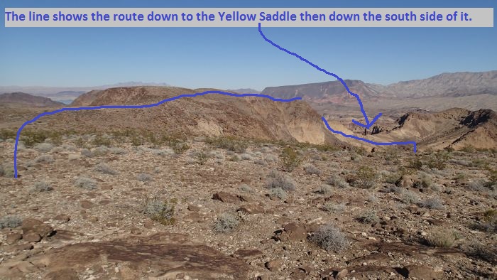
When
the yellow saddle
comes into view make
note of it since
that is where your
route will take you.
Shortly after the yellow
saddle has come into
view, you will cross over
a drainage
(wDevlsDrnRP01) which is shortly
before reaching a narrow
area on the ridge.
About 0.18 miles farther
you will cross along a
narrow area along the
ridge (wDevlsDrnRP02).
After the narrow section
along the ridge,
continue north toward
the high point about 0.2
miles away. As you
work your way up to the
high point you will
loose sight of the
yellow saddle. The
high point is a very
wide semi level area
that actually has two
high points with a
shallow saddle like spot
(wDevlsDrnRP03) between
them.
Note:
From this high point
area you have good
views down over parts of
the Colorado River below
the dam in the Black
Canyon area and views
over toward Lake Mead.
You can also see a small
part of the dam and the
new free way bridge that
bypasses the dam.
As you cross over the
high point(s), veer right
to start walking east
about 400 or 500 feet to the east
side of the high point
where a ride starts
(wDevlsDrnRP04) dropping
down east toward the
yellow saddle noted
earlier.
As you drop east down
the ridge the yellow
saddle noted earlier is
not clearly in view
again yet since there is
a high point along the
ridge which blocks the
view of it.
Getting down the ridge
will involve some
scrambling where you
will need hands and feet
to get down a couple
rough spots.
About 500 feet east down
the ridge the rock will
change from the dark
browns you have been on
to the yellow colored
rock (wDevlsDrnRP05).
This is about 700 feet
before getting to the
actual low point on the
saddle. When you
get here take a moment
to look at the area and
note a large drainage
dropping down from the
east on the south side
of the yellow saddle.
Route find your way down
to that drainage by
dropping off the south
side of the ridge and
also traversing east
over toward the
drainage. Aim for
a point in the wash like
portion of the drainage
that is almost due south
of the low point in the
yellow saddle (yDevilsDrainTp).
That drainage is the
start of the Devils
Drain Canyon route.
Note:
Rap 1 is a little over
100 feet down the
drainage from where you
drop in as described
above. Rap 1 drops
down through a hole in
the top of a natural
bridge crossing over the
water course. The
natural bridge is low
and
not easily seen until
you are right up on it.
This makes it hard to
give directions to it
via text or verbal.
If you aim for the wash
like area due south of
the low point of the
saddle you will be able
to walk down the wash
100 feet or so and
easily find rap 1.
Of note you can just
route find your way
right to the top of rap
1 if you know where to
go. If you have a
GPS with the coordinates
for rap 1 you can bee
line straight to it.
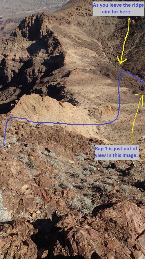
Make
your way down to the drainage as shown then walk down
the wash to the top of rap 1 which is just out of view
in this image.
The Canyoneering / Technical Section:
From where you
dropped into the
drainage (yDevilsDrainTp)
walk a little over 100
feet down to the natural
bridge that crosses over
the drainage. Walk
over onto the top of the
natural bridge to find a
hole that drops down
through it.
Rap 1 drops through that
hole.
Rap 1 (dDevlsDrnR1)
is on top of the natural
bridge over the water
course, is anchored from
a cairn anchor and drops
down through a hole in
the top of the bridge
about 75 feet down to
the canyon floor.
After dropping through
the hole the rest of the
rappel is free hanging.
Rap 2 (dDevlsDrnR2) is
anchored from a large
boulder LDC about 20
feet back and drops
about 15 feet.
Rap 3 is about 70 feet
down canyon of rap 2
with an easy downclimb
of about 5 feet between
them.
Rap 3 (dDevlsDrnR3) is
anchored from a boulder
a few feet back from the
drop and drops a total
of about 140 feet over
two stages.
Rap 4 (dDevlsDrnR4) is
about 350 feet down
canyon of rap 3, is
anchored from a large
rock in the wash and
drops about 100 feet
over two stages.
The first stage is
mostly vertical wall and
the second stage is a 20
foot drop.
Down canyon of rap 5 is
wash walking with a
couple spots to scramble
over short sections for
about 800 feet down to
where other side
drainages / ravines drop
in and the route turns
left (wDevlsDrnRP06) to
begin heading east
again. This is
also very close to a
point labeled on some
maps as Lone Rock.
About 400 feet down
canyon are a couple 15
foot drops
(wDevlsDrnRP07) to
downclimb / scramble
down.
About 1000 feet down
canyon is a drop of
about 25 feet
(wDevlsDrnRP08) that you
can get down by
carefully and slowly
sliding down.
About 200 feet down
canyon is the start of a
section of canyon where
you will be scrambling
down a boulder debris
area and a bunch of
vegetation starting.
This is also where you
will start to see hot
spring water begin to
flow in the canyon.
A little over 200 feet
down through this
boulder scrambling area
you will see a small
waterfall on the RDC
side (wDevlsDrnRP09) and
in the same area the
vegetation begins to get
VERY thick in the
canyon. This is
also where the water
course turns left and
begins to travel to the
east again. To save
yourself some serious
bushwhacking cut up the
LDC side of the canyon
and go up and over a
short slope to bypass
the thick vegetation in
the wash, then walk
along the less vegetated
LDC (north) bank up out
of the main wash.
Note:
When we were there in
Dec, 2012 there was a
big patch of dead
vegetation where we
found a way to cut up on
the LDC side to avoid
the thick vegetation in
the main drainage.
Features like a bunch of
dead brush etc do not
make long lasting
navigation landmarks.
But I suspect it will be
there for a long time.
So until things do
change you can use the
dead brush and trees as
a marker to know where
to turn up the LDC side
just up canyon of the
water fall joining in on
the RDC side.
After you cut up out of
the LDC side and start
walking the bench above
the vegetation lets up
about 150 feet and you
will be walking along a
wide open shelf just up
out of the main
drainage. Continue
east along this shelf
for about 400 feet and
drop back down into the
wash (wDevlsDrnRP10).
Where you drop back into
the wash there will be
heavy vegetation again
since the hot springs
water is flowing
steadily there.
But there is plenty of
clear space to walk
along the water course
enjoying warm water on
your feet.
Almost 400 feet down
canyon is a water fall
of about 8 feet
(wDevlsDrnRP11) which is
easily bypassed by
downclimbing on the LDC
side.
About 250 feet farther
down canyon is the top
of a water fall of about
15 feet (wDevlsDrnRP12).
This water fall is
bypassed by scrambling
about 15 feet up the
steep RDC wall then
traversing /
downclimbing down to the
canyon floor shortly
down canyon of the water
fall. The scramble
down is steep so be
careful. There are
occasionally sand bags
set here to dam up a
soaking pool.
About 1000 feet down
canyon of the 15 foot
waterfall is a
confluence (jDevilsConf)
where another fork joins
in from RDC (south).
From the confluence walk
the wash about 0.3 miles
to where Devils Drain
Canyon ends at a beach
along the Colorado River
(yDevilsDrainBt).
The Exit:
So far I
have only done a
packraft exit for this
canyon down to the
Arizona Hot Springs then
hiked out to Highway 93
on the Arizona side of
the river. If I
get a chance to explore
a hike out exit option
for Devils Drain Canyon
I will add it.
From
beach at the end of the
canyon (yDevilsDrainBt)
blow up your packraft
then
can raft south
downstream about 0.75
miles to a beach (lRingboltBeach)
on the opposite side
(east side) of the
river.
That beach is just
downstream of Ringbolt
Rapids and is where
boats can gain access to
the lower end of the
Ringbolt Hot Spring
(commonly referred to as
the Arizona Hot
Springs).
Note:
From the downstream exit
beach (lRingboltBeach)
you will then need to
hike east about 3 miles
out to Highway 93 and
the White Rock Canyon
Trailhead to complete
the packraft exit route.
There are a few possible
hiking routes to Highway
93. The one
described here is the
shortest route.
From the beach (lRingboltBeach)
walk about 100 feet up
from the water where you
will see a canyon
forming to the east.
That canyon is a dead
end. When you see
the canyon forming turn
left and start walking
north up the wash.
Follow the wash about
300 feet to where it
starts to turn into a
narrow canyon but still
plenty wide to walk in.
Continue following up
the wash as it winds
right and begins going
up to the east.
About 600 feet up the
canyon you will find a
couple spots where you
need to scramble up the
rock.
After a couple scramble
sections you will come
to a metal ladder
allowing access to the
top of a 30 foot
waterfall with hot /
warm water flowing over
it. At the top of
the ladder you may only
see flowing water or you
may find pools built by
sandbags damming up the
water. Welcome to
Ringbolt Hot Springs (hRingboltHtSp).
Ringbolt Hot Springs are
locally known as the
Arizona Hot Springs.
Note:
What you find in the way
of pools and sandbags
will depend on how much
work the locals have put
into the place recently.
This is a common place
to hike in to enjoy the
springs or kayak the
river to enjoy them.
Feel free to enjoy the
pools for a soak.
The upper pool will be
the warmest while the
lower pools will be
cooler.
After you wade through
the pools to get up
canyon of them you will
have a scramble up of
about 10 feet where you
may want to assist one
another with packs.
After getting to the top
of the upclimb /
scramble, you will find
a wide wash to walk in (sRingboltHS-Tp).
When you get to the wide
wash above the hot
springs walk east up the
wash for about 0.4 miles
to a narrow section of
canyon with a couple
short easy scrambles that soon turns
to yellow rock. As
the yellow rock narrow
section ends
(wRingboltRP01) you will
have wide wash again to
continue up canyon.
About 0.2 miles up the
wash will be the bottom
end (wRingboltRP02) of
another narrow section
with some short easy
scrambles to go up.
This narrow section
continues for about 750
feet to its top
(wRingboltRP03) where
the wide wash starts up
again.
Note -
Navigation Warning:
This is where you need
to be aware you will be
veering left up a side
canyon which is a little
tricky to find in the
day light sometimes.
If it is dark and you
are not familiar with
the area this turn off
will be VERY DIFFICULT
TO FIND. If you
are not familiar with
this area and are hiking
out in the dark, a GPS
will be very valuable.
A few hundred feet up
canyon after getting to
the top of the narrow
section note a ravine /
drainage on the left
(north). This
first ravine is going up
almost due north and is
NOT the ravine the route
goes up. However
the trail for the route
you want does leave the
main wash here.
Just as you pass the
ravine on the left
(north) start looking
for a faint use trail
running up and
traversing along the
left (north) side.
That is the start
(jRingboltAlt1)of the
route out of the main
wash. The trail is
hard to see right down
by the main wash but as
it travels a hundred
feet from the wash it is
very well used and
defined. So when
looking for the trail
look higher along the
left side to see the
better worn in portions
of the trail.
Follow up along the
trail as it goes up
canyon and slowly gets
higher on the left
(north) side. The
trail will soon veer
northeast as it starts
up a canyon / ravine
going up to the north
east.
Note - IF you pass the
bypass trail junction:
The main trail / route
used to continue up the
main wash then go left
at a fork farther up.
That route is longer and
has some upclimbs that
complicate the route.
The route described here
was a lesser known route
that bypassed the longer
route with upclimbs.
If you happen to miss
the turn up this canyon
you can still find your
way out by going about
0.2 miles up the wash
and going left at the
next fork. Then go
another 0.4 miles to the
next fork and go left at
that fork then follow
that up to connect with
this route again.
Just before reaching the
second fork will be a 20
foot scramble up
followed by a 25 foot
dry fall which is
bypassed on the left
(north). The green
line shown on the exit
route map shows the old
route that used to be
the main route.
Once you have found the
bypass trail and are
starting up into the
side ravine going up
northeast you will find
the trail well worn.
The trail does cross the
drainage a few times
traveling on one side or
the other. You may
need to look around
occasionally to find the
good parts of the trail
but they are there and
connect well if you look
for them.
About 0.8 miles after
leaving the main wash
the bypass trail tops
out on a saddle
(wRingboltRP05).
From the saddle follow
down the well worn use
trail northeast about
750 feet to where you
are met with a rocky
slope going up
(wRingboltRP06) about 20
feet. Do not
follow trails going
around the slope up,
instead go up the easy
20 foot scramble then
walk about 250 feet over
to a junction with
another very well used
trail (jRingboltOld3).
When you get to the
junction with this next
trail turn left to start
walking north.
Follow the trail about
0.2 miles north to where
it crosses a drainage
(wRingboltRP07).
Cross the drainage and
continue northeast about
800 feet to where the
trail drops down into
White Rock Canyon wash (jRingboltTp).
Once in the wash of
White Rock Canyon turn
right and follow
northeast up the wash
about 0.5 miles under
Highway 93 then up to
the parking area where
your exit vehicle at the
White Rock Canyon
Trailhead.
Downloadable GPX files
available at
BG-Gear Store
(easier than manual entry and a great way to support
Bluugnome).
Waypoint naming convention and map symbol information can be found on the Glossary page.
Elevations are approximate.
BEFORE
manually entering coordinates set your system to WGS84 datum and Lat/Lon hddd.ddddd° coordinate format.
Inconsistent datum's and coordinate formats will result in location errors.
Click to show / expand the list of waypoints below........
| Devils Drain (1) Drive in to Trailhead |
- extUtah-Adams
Lat/Lon (WGS84): N 35.97106
W -114.82203
Elev: NaN Feet
Intersection of Utah Street and Adams Blvd. Follow Utah Street South east to go to some of the dirt roads in the Lake Mead National Recreation area.
- extMtrcyclAlt
Lat/Lon (WGS84): N 35.96476
W -114.81522
Elev: NaN Feet
Exit off of Utah Street to start on dirt roads north out toward Goldstrike Pass Road. This is the dirt road you would drive on to start Motorscycle Canyon if you were to do the car shuttle version of the route.
- extUtah-CnynPt
Lat/Lon (WGS84): N 35.96431
W -114.81192
Elev: NaN Feet
Intersection of Utah Street and Canyon Point Road. Turn right (south) onto Canyon Point Road to go to some of the dirt roads in the Lake Mead National Recreation area.
- extLkMdRoad58
Lat/Lon (WGS84): N 35.95274
W -114.80673
Elev: 2,326 Feet
Exit the paved road to start southeast onto a dirt road. The dirt road continuing southeast of here is still Canyon Point Road and is Road 58 in the Lake Mead Nat. Rec Area Backcountry Road System. This turn off is in a sharp bend on the paved road and the dirt road continues southeast.
- wRaod58DP-01
Lat/Lon (WGS84): N 35.95190
W -114.80473
Elev: NaN Feet
Fork in the road. Stay right at the fork and continue southeast to continue driving out on road 58 (Canyon Point Road).
- wRaod58DP-02
Lat/Lon (WGS84): N 35.95012
W -114.80079
Elev: NaN Feet
Fork in the road.
If you are on your way into the top of Devils Drain Canyon or Weeping Spring Canyon stay right at the fork and continue southeast on Road 58 (Canyon Point Road).
If you are on your way to the top of Boyscout Canyon stay left at the fork and drive east.
- extRaod58-58A
Lat/Lon (WGS84): N 35.93858
W -114.75947
Elev: NaN Feet
Intersection of Lake Mead Backcountry Roads 58 and 58A.
Road 58 (Canyon Point Road) continues southeast. Follow Road 58 is you are going out to the top of Weeping Spring Canyon.
Raod 58A (Canyon Point Mesa Road) turns off and travels north. Follow Road 58A if you are driving into the top of Devils Drain Canyon.
|
| Devils Drain (2) Approach |
- extRaod58-58A
Lat/Lon (WGS84): N 35.93858
W -114.75947
Elev: NaN Feet
Intersection of Lake Mead Backcountry Roads 58 and 58A.
Road 58 (Canyon Point Road) continues southeast. Follow Road 58 is you are going out to the top of Weeping Spring Canyon.
Raod 58A (Canyon Point Mesa Road) turns off and travels north. Follow Road 58A if you are driving into the top of Devils Drain Canyon.
- wRaod58A-DP-01
Lat/Lon (WGS84): N 35.94499
W -114.75750
Elev: NaN Feet
A switchback in the road to go up to the next higher shelf.
- jDevilsDrain
Lat/Lon (WGS84): N 35.95539
W -114.75638
Elev: 2,380 Feet
This is a point in Lake Mead Backcountry Road 58A (Canyon Point Mesa Road) where it starts to turn to the east. Leave the road here and start walking north along the very wide, flat and open ridge.
- wDevlsDrnRP01
Lat/Lon (WGS84): N 35.96760
W -114.75846
Elev: NaN Feet
Cross over a drainage here shortly before getting to a narrow area along the ridge.
- wDevslDrnRP02
Lat/Lon (WGS84): N 35.96922
W -114.75688
Elev: NaN Feet
Crossing over a narrow area along the ridge. Continue north to stay on the route into Devils Drain Canyon.
- wDevlsDrnRP03
Lat/Lon (WGS84): N 35.97223
W -114.75559
Elev: 2,400 Feet
A shallow saddle like spot between two high points on a very wide flatish area.. Go east about 400 feet to drop down the east side to drop down towards Devils Drain Canyon.
- wDevlsDrnRP04
Lat/Lon (WGS84): N 35.97261
W -114.75326
Elev: NaN Feet
Ridge starts dropping down to the east.
- wDevlsDrnRP05
Lat/Lon (WGS84): N 35.97244
W -114.75141
Elev: NaN Feet
This is a point about 500 feet down the ridge where the rock changes from the dark browns you have been on to the yellow colored rock. This is about 700 feet before getting to the actual low point on the saddle. When you get here take a moment to look at the area and note a large drainage dropping down from the east on the south side of the yellow saddle. Route find your way down to that drainage by dropping off the south side of the ridge and also traversing east over toward the drainage. Aim for a point in the wash like portion of the drainage that is almost due south of the low point in the yellow saddle. That drainage is the start of the Devils Drain Canyon route.
- yDevilsDrainTp
Lat/Lon (WGS84): N 35.97105
W -114.74976
Elev: 1,890 Feet
Top of Devils Drain Canyon. This is an arbitrary point shortly above rap 1 which is through an arach in the water course.
|
| Devils Drain (3) The Canyon and the Raft |
- yDevilsDrainTp
Lat/Lon (WGS84): N 35.97105
W -114.74976
Elev: 1,890 Feet
Top of Devils Drain Canyon. This is an arbitrary point shortly above rap 1 which is through an arach in the water course.
- dDevlsDrnR1
Lat/Lon (WGS84): N 35.97054
W -114.75010
Elev: NaN Feet
Rap 1 - Devils Drain Canyon. Rap 1 is on top of the natural bridge over the water course, is anchored from a cairn anchor and drops down through a hole in the top of the bridge about 75 feet down to the canyon floor. After dropping through the hole the rest of the rappel is free hanging.
- dDevlsDrnR2
Lat/Lon (WGS84): N 35.97006
W -114.75085
Elev: NaN Feet
Rap 2 - Devils Drain Canyon. Anchored from a large boulder LDC about 20 feet back and drops about 15 feet.
- dDevlsDrnR3
Lat/Lon (WGS84): N 35.96997
W -114.75104
Elev: NaN Feet
Rap 3 - Devils Drain Canyon. Anchored from a boulder a few feet back from the drop and drops a total of about 140 feet over two stages.
- dDevlsDrnR4
Lat/Lon (WGS84): N 35.96901
W -114.75121
Elev: NaN Feet
Rap 4 - Devils Drain Canyon. Is about 350 feet down canyon of rap 3, is anchored from a large rock in the wash and drops about 100 feet over two stages. The first stage is mostly vertical wall and the second stage is a 20 foot drop.
- wDevlsDrnRP06
Lat/Lon (WGS84): N 35.96703
W -114.75104
Elev: 1,260 Feet
A few other side drainages / ravines drop in and the route turns left to continue down canyon to the east. This is also very close to a point labeled on some maps as Lone Rock.
- wDevlsDrnRP07
Lat/Lon (WGS84): N 35.96704
W -114.74952
Elev: NaN Feet
A couple 15 foot drops to downclimb / scramble.
- wDevlsDrnRP08
Lat/Lon (WGS84): N 35.96584
W -114.74685
Elev: NaN Feet
A drop of about 25 feet that you can get down by carefully and slowly sliding down
- wDevlsDrnRP09
Lat/Lon (WGS84): N 35.96484
W -114.74656
Elev: 970 Feet
A small waterfall on the RDC side and the vegetation begins to get VERY thick. This is also where the water course turns left and begins to travel to the east again. To save yourself some serious bushwhacking cut up the LDC side of the canyon and go up and over a short slope to bypass the thick vegetation in the wash, then walk along the less vegetated LDC (north) bank up out of the main wash.
- wDevlsDrnRP10
Lat/Lon (WGS84): N 35.96520
W -114.74470
Elev: NaN Feet
Where you drop back into the wash. There will be heavy vegetation again since the hot springs water is flowing steadily there. But there is plenty of clear space to walk along the water course enjoying warm water on your feet.
- wDevlsDrnRP11
Lat/Lon (WGS84): N 35.96515
W -114.74342
Elev: NaN Feet
Small water fall of about 8 feet that is easily bypassed on the LDC side.
- jDevilsConf
Lat/Lon (WGS84): N 35.96592
W -114.73915
Elev: 760 Feet
A confluence in Devils Drain Canyon. Another fork joins in from RDC (south).
- yDevilsDrainBt
Lat/Lon (WGS84): N 35.96777
W -114.73604
Elev: 680 Feet
Bottom of Devils Drain Canyon where it ends at a beach along the Colorado River.
- lRingboltBeach
Lat/Lon (WGS84): N 35.95944
W -114.72828
Elev: 650 Feet
Out houses put here and is a good camp area just below the Arizona Hot Springs (Ringbolt Hot Spring). This is slighlty downstream of Ringbolt Rapids.
|
| Devils Drain (4) Exit hike via Ringbolt Hot Springs |
- lRingboltBeach
Lat/Lon (WGS84): N 35.95944
W -114.72828
Elev: 650 Feet
Out houses put here and is a good camp area just below the Arizona Hot Springs (Ringbolt Hot Spring). This is slighlty downstream of Ringbolt Rapids.
- hRingboltHtSp
Lat/Lon (WGS84): N 35.96057
W -114.72550
Elev: 810 Feet
Ring Bolt Hot Springs (Arizona Hot Springs).
- sRingboltHS-Tp
Lat/Lon (WGS84): N 35.96083
W -114.72514
Elev: NaN Feet
Top of the Arizona hot Springs.
- wRingboltRP01
Lat/Lon (WGS84): N 35.96246
W -114.72047
Elev: NaN Feet
Spot in the wash just up canyono of a yellow rock section.
- wRingboltRP02
Lat/Lon (WGS84): N 35.96395
W -114.71761
Elev: NaN Feet
Lower end of another narrow section about 750 feet long with some short easy scrambles in it.
- wRingboltRP03
Lat/Lon (WGS84): N 35.96486
W -114.71516
Elev: NaN Feet
Upper end of another narrow section about 750 feet long with some short easy scrambles in it.
- jRingboltAlt1
Lat/Lon (WGS84): N 35.96523
W -114.71427
Elev: 1,090 Feet
This is where the bypass trail meets the main canyon / wash. On the way out the trail can be seen starting up into the hills on the left (north) side of the canyon about 500 feet before actually reaching the drainage the trail goes up. This is very difficult to find in the dark if you are not familiar with the route. A GPS will save your butt if you exit this area in the dark and are not familiar with it.
- wRingboltRP04
Lat/Lon (WGS84): N 35.96638
W -114.71290
Elev: NaN Feet
The Bypass trail crosses over the bottom of the drainage several times.
- wRingboltRP05
Lat/Lon (WGS84): N 35.97077
W -114.70930
Elev: 1,530 Feet
Bypass trail tops out here on a saddle with great views toward the main trailhead.
- wRingboltRP06
Lat/Lon (WGS84): N 35.97182
W -114.70749
Elev: 1,430 Feet
On the way out to the highway it feels like you need to go right or left of the hill you get to. Go up over the hill to the top of the ridge and continue straight (north east) to the main trail.
- jRingboltOld3
Lat/Lon (WGS84): N 35.97220
W -114.70653
Elev: 1,450 Feet
The bypass trail meets the old standard trail here. On the way out to the highway turn left here to walk north.
- wRingboltRP07
Lat/Lon (WGS84): N 35.97463
W -114.70497
Elev: 1,410 Feet
Trail for the upper canyon route to the Arizona Hot Springs crosses a small drainage.
- jRingboltTp
Lat/Lon (WGS84): N 35.97598
W -114.70352
Elev: NaN Feet
Trail to the top of the Arizona Hot Springs joins the White Rock Canyon wash here.
- tWhiteRockCyn
Lat/Lon (WGS84): N 35.98022
W -114.69768
Elev: 1,560 Feet
White Rock Canyon Trailhead. Used to access the Arizona Hot Springs (Ringbolt Hot Springs).
|