Canyoneering Route Description
Egypt 2 Canyon 3A I
Escalante National Monument, Utah
05-26-18, 4 people, 1 Day (Travel time in route 6.5 hours)
 We did the down E2 and up E3 loop which is why the time seems long
Time Required - 2.5 to 4 hours
Distance - 2.9 miles Total, 1.4 miles Technical
Rappels - 2 Rappels, Longest Rappel 270 feet.
Elevation Range - 5390 - 4800 Feet
Shuttle Required - No Vehicle - High Clearance, 4WD if bad road conditions
Permit Required - No
Rappelling and anchor gear, Ropes and or pull cords for rappels up
to 300 feet and 30 feet of 1 inch webbing for sling placement.
A 300 foot rope can be rigged and left at the entry rappel and
retrieved on after exiting the canyon. Shorter rope and pull
cord options can be hauled through the canyon for the shorter raps
of up to 25 feet.
Egypt 2 is a fun short scenic route worth the trip.
The canyon has a huge entry rap right at the head of the canyon by the road,
multiple downclimbs, long corridors, deep narrow sections and a couple spots
where you will need to stem / galumph up a few feet over skinny spots.
Even the big guys can get through Egypt 2 since they will stem / galumph
over the short skinny spots just like everyone else.
Egypt 2 will generally be dry except after recent heavy
rain activity so no wet suits are needed. Keep in mind that the dirt
here has a lot of clay and can become very slick and messy when wet.
So if there is water, plan on getting dirty and working a little extra to
deal with the super slick mud.
There are a few ways down into the the start of E2. The
route described here enters right at the head of the canyon near the road
and does so by rappelling about 270 feet right at the head. The anchor
we chose is RDC of the watercourse and is anchored from a rock outcropping
about 25 feet back and used about 270 feet of rope. There are other anchor
options which may increase the amount of rope needed. Best to bring a 300
foot rope as some anchor options may require it. The rope is left rigged at
the top and retrieved when you return from the route so the long rope dose
not need to be hauled through the canyon. Shorter rope and pull cord
options can be hauled through the canyon for the shorter raps of up to 25
feet.
There are other entry options to use shorter ropes
located down canyon on the LDC side but these are not covered in this route
description.
The standard exit for E2 is to descend the canyon until
it opens to wide wash walking, scramble out the RDC side near a side slot
dropping in then hike rolling slickrock up to the E1.5 exit which takes you
up onto the rolling desert where you hike back to the road at the top of
Egypt 1.5 where you then walk the road back to your car at the top of Egypt
2.
Note - Cotton Woods
If you are
there when the cotton woods are dropping their cotton (for us it was march
2018) it is worth the time to go take a look. From the standard exit
for E2 continue down canyon about 0.3 miles of wide easy wash walking to the
confluence with E3. If the cotton wood trees are dropping cotton you
may catch it like we did when the cotton is so thick it is like thick snow.
Very cool to see. For a few pics of what it looks like see the picture album
from May of 2018.
Note - Loop route for both E2 and E3
A common loop route is to combine Egypt 2 and Egypt 3 Canyons into
one loop route. The route is to descend E2 passing the standard exit
point and continuing down to the confluence of E2 and E3, from the
confluence scramble up the nose between the canyons then drop down into E3
above the lower slot, upclimb E3 canyon to near the top and exit up to the
road then follow the road back to your car. If you go at the right
time of year the cotton woods in E2 just before the confluence has so much
cotton fallen from the trees it looks like thick heavy snow. It gets
very thick and is worth the time to go see if there at the right time. We
were there late may 2018 and it was very thick. I have never seen anything
like it. For a few pics of what it looks like see the picture album
from May of 2018.
If doing E2 and up E3 loop it is best done when the
canyons are dry. The upper portions of E3 require scrambling and quasi
stemming to get up sloped but smooth drops. The potholes in that section
have clay dirt that will form slick mud when wet and can make passage up E3
very difficult or impossible. When dry it is only moderately challenging.
Lower portions of Egypt 3 canyon has a few
skinny spots that will prove troublesome for large barrel chested people.
At 6 foot even and 190 pounds I was able to fit through these sections with
out much of a struggle but it was pretty close. Another person on the trip
at 5 foot 9 inches and about 185 pounds fit through as well but had to
struggle a bit more in two places. The skinniest spots are about 1000 feet
up canyon of the standard E3 exit.
If you want to do the E2 E3 loop and doubts if
you can fit, you can test the fit and retreat if needed. Since the skinny
stuff is near the bottom of E3 you can descend E2, go over to the bottom of
E3 and start up. If you fit through the skinny sections you encounter
you're good to go. If you find you do not fit you can always turn around
and go back to the standard exit for E2 and use the E2 exit to go back.
Having the skinny stuff near the lower end of E3 means you are not committed
to a huge day if you find you do not fit. If you do not fit you will find
that out in the first 1000 to 1500 feet of the lower part of E3.
If you want to do E3 but are concerned about your size
the E2 E3 loop is the best choice since you can test your fit and if you do
not fit you still got to a see E2 which is a pretty cool place.
Descending down E3 from the top and finding you do not fit would make it
more difficult to turn around and go back up.
To get to the Trailhead
From the city of Escalante drive about 4 miles southeast on Hwy
12 to the turn off for Hole-In-The-Rock road on the right (extHoleInRock).
The Hole-In-The-Rock road is dirt. The condition of the road
varies
a lot with recent rains and road maintenance. High clearance
may be needed in extreme cases but most of the time passenger
cars will be fine for the first 30 or 40 miles on Hole in the
Rock road.
Travel about 16.5 miles southeast on Hole-In-The-Rock road to the
turn off on the left (east) for the Egypt road (extEgypt).
Turn left and travel down the Egypt road.
The Egypt road is generally well maintained but a few spots may
be difficult with 2WD low clearance vehicles. A vehicle
with high clearance is VERY helpful and 4WD may be useful but
generally not needed.
The first obstacle is about 3.4 miles in where the Egypt road
crosses over Twentyfive Mile Wash (EgyptDP-01). On the
drive in this is generally in good condition as you drop down a
hill into then across the wash. Driving back out can be a
little difficult with a 2WD vehicle since the hill is steep and
a little speed may be required. The rough wash leading to
the hill may make it difficult to get up to speed.
After crossing Twentyfive Mile Wash, continue on the Egypt road
for about 3.2 miles to where the road crosses over the Egypt 1
drainage (pkEgypt1). At this drainage there is what appears to
be a road forking to the left going up the Egypt 1 drainage.
Continue east on the road about 0.7 miles to the top of Egypt
1.5 (pkEgypt1.5).
Continue east on the road about 0.5 miles to the parking spot
for Egypt 2 (PkEgypt2). The head of Egypt 2 is only a few
feet off to the right (south) of the road. Park here to start the route.
To leave the Exit Vehicle / Escape Pod
No exit vehicle is needed. This is done as a loop route.
GPS coordinate information listed at the bottom. For information about waypoint naming and map symbols, refer to the
Glossary page.

Click the links for maps of the route.
Map of the drive into the route.
Map of the entire route.
The Approach:
From parking spot
(PkEgypt2) walk a few
feet east from the road
to the head of the
Canyon (yEgypt2Tp).
The Canyoneering / Technical Section:
From the head of
the canyon (yEgypt2Tp)
anchor from a rock
outcropping RDC of the
head of the canyon for
the canyon entry rappel.
The anchor we used was a
bout 25 feet back from
the drop and used about
270 feet of rope to the
canyon floor. There are
multiple places where
you can rig a rappel.
Using a 300 foot rope is
a good idea since some
anchor options will
require more rope.
Continue down canyon
with easy walking in
long corridors and the a
couple easy downclimbs
of 6 to 8 feet sprinkled
in.
About 1100 feet down
canyon from the head is
boulder debris
(Egypt2-01) where you
walk under a large
boulder. Continue down
canyon with easy walking
in a long corridor.
About 300 feet farther
is an easy stem
downclimb of about 10
feet (Egypt2-02).
About 175 feet farther a
side drainage
(Egypt2-03) drops in
from LDC that would be
difficult to scramble up
into.
A little over 200 feet
farther is rap 2.
Rap 2 (dEgypt2-R2) is
anchored from a choke
stone and drops about 25
feet. This rap can be
downclimbed with only
the first 8 feet being
difficult and the
remainder being a pretty
easy downclimb. It may
be best to use a
handline for the first 8
feet which are wide then
downclimb the remainder.
Over the next 700 feet
the canyon becomes
deeper and more narrow
where you will need to
stem / galumph a few
feet up in a couple
places to get over short
skinny spots.
Followed by a sloped
drop of about 15 feet
that is easily
downclimbed and the
walls become more
winding and undulating
still in narrow canyon.
The narrow section will
give way to a short wide
open section (Egypt2-04)
before the canyon gets
narrow again. Over the
next 800 feet the canyon
is narrow and corridor
like with multiple easy
downclimbs of 4 to 8
feet each.
The canyon becomes a
little wider and is
easier walking just as a
small ravine drops in
(Egypt2-05) on the RDC
side and the canyon
makes a sharp left hand
bend. The next 1400 feet
of canyon is mostly long
narrow corridors with a
few short easy
downclimbs and one spot
that will take some
effort to keep your feet
dry if there is water.
The narrows seem to just
keep going for a long
while and farther down
canyon you will need to
turn sideways in a few
spots but even the
bigger guys will fit
well.
There is a downclimb
about 10 feet
(Egypt2-06) as the
canyon begins to have
very curvy and
undulating walls and
less of a corridor feel.
About 120 feet after the
down climb is a very
wide chamber like spot
with wider easy walking
continuing down canyon.
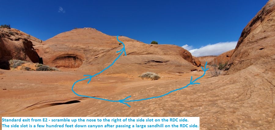
About 0.3 miles farther
is a large sand hill
(Egypt2-07) on the RDC
(west) side that looks
like you may be able to
get up to the rim if you
tried.
About 750 feet past the
sand hill is a side slot
drops in from the RDC
side (Egypt2-08-EE).
This is the standard
exit for Egypt 2.
To follow the
standard exit out of E2,
scramble up the sloped
slickrock nose on the
right (upcanyon) side of
the side slot.
To
see the remainder of the
lower portion of E2 you
can walk about 0.4 miles
down to the confluence
of E2 and E3 in wide
easy wash walking.
If
doing the down E2 and up
E3 loop continue down
canyon about to the
confluence of E2 and E3
or continue only about
600 feet down canyon to
where you can scramble
up the LDC side sooner
to shorten the route a
little bit.
The Exit:
Note - Lower
portion of E2
To see the remainder of
the lower portion of E2
you can walk about 0.4
miles down to the
confluence
(E2-E3-Conf-EE) of E2 and E3
in wide easy wash
walking then return to
the standard exit to
leave.
Note - Loop
route of E2 and E3
If
doing the down E2 and up
E3 loop, continue down
canyon about 0.4 miles to the
confluence
(E2-E3-Conf-EE) of E2 and E3
or optionally scramble
up steep slickrock
earlier to short cut the
route a little.
Once at the confluence
scramble up the nose
between the two
drainages then walk
rolling slickrock about
0.25 miles to where you
can scramble down into
Egypt 3 to the east.
Follow up E3 then follow
an exit route near the
top to get back to the
road. For more
over view comments of
this, see the general
comments section of both
the E2 and E3 route
descriptions. For
details about E3 and the
upper exit refer to the
E3 route description.
To follow
the standard exit from
E2, scramble up the
sloped slickrock nose on
the right (upcanyon)
side of the side slot
(Egypt2-08-EE).
To continue the standard
exit from E2, scramble
up the slickrock ramp
(Egypt2-08-EE) as noted
above then route find
your way north up
rolling slickrock. As
you walk north route
find your way to the
base of a prominent flat
topped peak about 0.6
miles away.
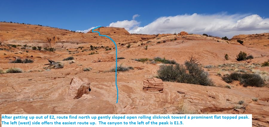
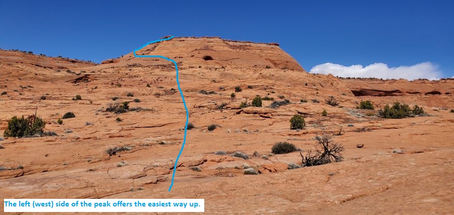
Once near the base of
the flat topped peak,
begin scrambling up
steep slickrock near the
left (west) side.
As the slickrock becomes
too steep for safe
travel (wEgypt1-5-RP7)
traverse left (west)
toward E1.5 canyon to a
much easier way around
the steep part with one
easy upclimb.
Once up on top of the
mesa in flat rolling
desert (wEgypt1-5-RP8)
follow use trails north
for about 0.25 miles
back to the road
(pkEgypt1.5) near the
head of Egypt 1.5.
Once at the road
(pkEgypt1.5) turn right
and walk east along the
road for about 0.5 miles
back to your car
(PkEgypt2).
Downloadable GPX files
available at
BG-Gear Store
(easier than manual entry and a great way to support
Bluugnome).
Waypoint naming convention and map symbol information can be found on the Glossary page.
Elevations are approximate.
BEFORE
manually entering coordinates set your system to WGS84 datum and Lat/Lon hddd.ddddd° coordinate format.
Inconsistent datum's and coordinate formats will result in location errors.
Click to show / expand the list of waypoints below........
| Egypt 2 (1) - Drive to Trailhead |
- extHoleInRock
Lat/Lon (WGS84): N 37.72769
W -111.53143
Elev: NaN Feet
Turn off to Hole-In-The-Rock road from Hwy 12.
- extEgypt
Lat/Lon (WGS84): N 37.54114
W -111.36176
Elev: 5,279 Feet
Turn off to the Egypt Road to the east (left on the drive in on Hole in the Rock road..
- EgyptDP-01
Lat/Lon (WGS84): N 37.56107
W -111.30718
Elev: 4,924 Feet
Egypt Road crosses over Twentyfive Mile Wash. Generally in good condition but may be a little difficult to get back up the hill on the drive back to the Hole in the Rock road. The hill is steep up out of the wash and a 2WD vehicle will need a little speed which is difficult since crossing the wash can be rough.
- pkEgypt1
Lat/Lon (WGS84): N 37.57269
W -111.25778
Elev: 5,270 Feet
Park here to start the Egypt 1 route.
- pkEgypt1.5
Lat/Lon (WGS84): N 37.57647
W -111.24791
Elev: 5,350 Feet
Park here in one of a couple clearings on the right (south) side of the road to start the Egypt 1.5 route.
- PkEgypt2
Lat/Lon (WGS84): N 37.58118
W -111.24291
Elev: 5,390 Feet
Park here to start down Egypt 2 canyon. If driving farther up the Egypt Road, just after crossing this drainage is a rough section where you will need a high clearance vehicle to navigate through the slickrock in the drainage.
|
| Egypt 2 (2) - The Canyon |
- PkEgypt2
Lat/Lon (WGS84): N 37.58118
W -111.24291
Elev: 5,390 Feet
Park here to start down Egypt 2 canyon. If driving farther up the Egypt Road, just after crossing this drainage is a rough section where you will need a high clearance vehicle to navigate through the slickrock in the drainage.
- yEgypt2Tp
Lat/Lon (WGS84): N 37.58101
W -111.24271
Elev: NaN Feet
Top of Egypt 2 Canyon.
For the long rappel entry at the head of the canyon near the road, anchor from a rock outcropping RDC of the head of the canyon for the canyon entry rappel. The anchor we used was a bout 25 feet back from the drop and used about 270 feet of rope to the canyon floor. There are multiple places where you can rig a rappel. Using a 300 foot rope is a good idea since some anchor options will require more rope.
Continue down canyon with easy walking in long corridors and the a couple easy downclimbs of 6 to 8 feet sprinkled in.
- Egypt2-01
Lat/Lon (WGS84): N 37.57813
W -111.24134
Elev: NaN Feet
Boulder debris where you walk under a large boulder. Continue down canyon with easy walking in a long corridor.
- Egypt2-02
Lat/Lon (WGS84): N 37.57734
W -111.24151
Elev: NaN Feet
Easy stem downclimb of about 10 feet.
- Egypt2-03
Lat/Lon (WGS84): N 37.57690
W -111.24155
Elev: NaN Feet
Side drainage drops in from LDC that would be difficult to scramble up into.
- dEgypt2-R2
Lat/Lon (WGS84): N 37.57629
W -111.24167
Elev: NaN Feet
Rap 2 - E2 canyon. Anchored from a choke stone and drops about 25 feet. This rap can be downclimbed with only the first 8 feet being difficult and the remainder being a pretty easy downclimb. It may be best to use a handline for the first 8 feet which are wide then downclimb the remainder.
Over the next 700 feet the canyon becomes deeper and more narrow where you will need to stem / galumph a few feet up in a couple places to get over short skinny spots. Followed by a sloped drop of about 15 feet that is easily downclimbed and the walls become more winding and undulating still in narrow canyon.
- Egypt2-04
Lat/Lon (WGS84): N 37.57436
W -111.24224
Elev: NaN Feet
Short wide open section before the canyon gets narrow again. Over the next 800 feet the canyon is narrow and corridor like with multiple easy downclimbs of 4 to 8 feet each.
- Egypt2-05
Lat/Lon (WGS84): N 37.57310
W -111.24432
Elev: NaN Feet
Canyon becomes a little wider and is easier walking just as a small ravine drops in on the RDC side and the canyon makes a sharp left hand bend. The next 1400 feet of canyon is mostly long narrow corridors with a few short easy downclimbs and one spot that will take some effort to keep your feet dry if there is water. The narrows seem to just keep going for a long while and farther down canyon you will need to turn sideways in a few spots but even the bigger guys will fit well.
- Egypt2-06
Lat/Lon (WGS84): N 37.56939
W -111.24434
Elev: NaN Feet
Downclimb about 10 feet as the canyon begins to have very curvy and undulating walls and less of a corridor feel. About 120 feet after the down climb is a very wide chamber like spot with wider easy walking continuing down canyon.
- Egypt2-07
Lat/Lon (WGS84): N 37.56504
W -111.24627
Elev: NaN Feet
Large sand hill on the RDC (west) side that looks like you may be able to get up to the rim if you tried.
- Egypt2-08-EE
Lat/Lon (WGS84): N 37.56330
W -111.24754
Elev: 4,827 Feet
Side slot drops in from the RDC side about 750 feet down canyon of a sand hill on the RDC side.
To follow the standard exit out of E2, scramble up the sloped slickrock nose on the right (upcanyon) side of the side slot.
To see the remainder of the lower portion of E2 you can walk about 0.4 miles down to the confluence of E2 and E3 in wide easy wash walking then return to the standard exit to leave..
If doing the down E2 and up E3 loop, continue down canyon about 0.4 miles to the confluence of E2 and E3 or optionally scramble up steep slickrock earlier to short cut the route a little.
|
| Egypt 2 (3) - Standard Exit |
- Egypt2-08-EE
Lat/Lon (WGS84): N 37.56330
W -111.24754
Elev: 4,827 Feet
Side slot drops in from the RDC side about 750 feet down canyon of a sand hill on the RDC side.
To follow the standard exit out of E2, scramble up the sloped slickrock nose on the right (upcanyon) side of the side slot.
To see the remainder of the lower portion of E2 you can walk about 0.4 miles down to the confluence of E2 and E3 in wide easy wash walking then return to the standard exit to leave..
If doing the down E2 and up E3 loop, continue down canyon about 0.4 miles to the confluence of E2 and E3 or optionally scramble up steep slickrock earlier to short cut the route a little.
- wEgypt1-5-RP7
Lat/Lon (WGS84): N 37.57254
W -111.24772
Elev: NaN Feet
A section just before getting up onto the the flat dirt mesa top where the slickrock becomes too steep to safely travel. Traverse left (west) toward E1.5 canyon to a much easier way around the steep part with one easy upclimb.
- wEgypt1-5-RP8
Lat/Lon (WGS84): N 37.57289
W -111.24768
Elev: 5,300 Feet
Follow use trails north for about 0.25 miles back to the road.
- pkEgypt1.5
Lat/Lon (WGS84): N 37.57647
W -111.24791
Elev: 5,350 Feet
Park here in one of a couple clearings on the right (south) side of the road to start the Egypt 1.5 route.
|
| Egypt 2 (4) - Optional walk down to confluence |
- Egypt2-08-EE
Lat/Lon (WGS84): N 37.56330
W -111.24754
Elev: 4,827 Feet
Side slot drops in from the RDC side about 750 feet down canyon of a sand hill on the RDC side.
To follow the standard exit out of E2, scramble up the sloped slickrock nose on the right (upcanyon) side of the side slot.
To see the remainder of the lower portion of E2 you can walk about 0.4 miles down to the confluence of E2 and E3 in wide easy wash walking then return to the standard exit to leave..
If doing the down E2 and up E3 loop, continue down canyon about 0.4 miles to the confluence of E2 and E3 or optionally scramble up steep slickrock earlier to short cut the route a little.
- Egypt2-09
Lat/Lon (WGS84): N 37.56266
W -111.24738
Elev: NaN Feet
Upper end of a 300 foot long 5 foot deep shallow V-slot.
- Egypt2-10
Lat/Lon (WGS84): N 37.56194
W -111.24805
Elev: NaN Feet
Lower end of a 300 foot long 5 foot deep shallow V-slot.
- Egypt2-11-EE
Lat/Lon (WGS84): N 37.56157
W -111.24791
Elev: NaN Feet
Just after the shallow V-slot ends you can scramble up where ever you like on the LDC side to start over to E3 to begin going up E3 for the loop hike. Or you can can continue down canyon in wide easy wash walking for about 1400 feet down to the confluence of E2 and E3.
- E2-E3-Conf-EE
Lat/Lon (WGS84): N 37.55832
W -111.24714
Elev: 4,770 Feet
Confluence of E2 and E3. Just before the confluence are a lot of cotton wood trees in both E2 and in E3. The trees can release a LOT of cotton at certain times of the year making it appear like snow. To exit up from the confluence scramble up steep slickrock on the nose between the two canyons. A short ways up the grade levels off to gently sloped rolling slickrock.
|