Canyoneering Route Description
Egypt 1 Canyon 3A I
Escalante National Monument, Utah
04-14-13, 7 people, 1 Day (Travel time in route 1.9 hours)

05-24-13, 8 people, 1 Day (Travel time in route 2.75 hours)
(pictures from Egypt 1 and 1.5)
04-08-18, 5 people, 1 Day (Travel time in
route 2.6 hours)
04-20-19, 5 people, 1 Day (Travel time in route 2.25
hours)
Time Required - 2 to 4 hours
Distance - 1.7 miles Total, 0.8 miles Technical
Rappels - 0 to 4 Rappels (depending on skill
level), Longest Rappel 30 feet. Regardless of skill,
always bring rope incase there is mud.
Elevation Range - 5270 - 4940 Feet
Shuttle Required - No Vehicle - High Clearance
recommended, 4WD if bad road conditions
Permit Required - No
Rappelling and anchor gear, ropes and or pull cords for rappels up
to 30 feet and about 30 feet of webbing for possible anchor
replacement.
Egypt 1 and Egypt 1.5 are great short canyons requiring
only a few hours each. You can easily do both canyon in one day and still
have a lot of time left. If you are short on time or just want a fun
evening route to do before going back to camp, Egypt 1 or Egypt 1.5 fit the bill
nicely.
Egypt 1 is a great beginner canyon that provides a
great scenic treat with minimal effort in a short fun filled day and totally
worth the visit.
Egypt 1.5 offers a little less in the scenery
department but offers a step up in challenges giving you the opportunity to
practice some partner assist style downclimbs.
Bring a small pack since there are a few spots you will
need to take it off and turn sideways a short distance to get down canyon.
Warning:
It is possible to
downclimb the entire canyon for those with good downclimbing skills and a team strong in partner
assists. However, regardless of skill, always bring rope incase
there is mud.
To get to the Trailhead
From the city of Escalante drive about 4 miles southeast on Hwy
12 to the turn off for Hole-In-The-Rock road on the right (extHoleInRock).
The Hole-In-The-Rock road is dirt. The condition of the road
varies
a lot with recent rains and road maintenance. High clearance
may be needed in extreme cases but most of the time passenger
cars will be fine for the first 30 or 40 miles on Hole in the
Rock road.
Travel about 16.5 miles southeast on Hole-In-The-Rock road to the
turn off on the left (east) for the Egypt road (extEgypt).
Turn left and travel down the Egypt road.
The Egypt road is generally well maintained but a few spots may
be difficult with 2WD low clearance vehicles. A vehicle
with high clearance is VERY helpful and 4WD may be useful but
generally not needed.
The first obstacle is about 3.4 miles in where the Egypt road
crosses over Twentyfive Mile Wash (EgyptDP-01). On the
drive in this is generally in good condition as you drop down a
hill into then across the wash. Driving back out can be a
little difficult with a 2WD vehicle since the hill is steep and
a little speed may be required. The rough wash leading to
the hill may make it difficult to get up to speed.
After crossing Twentyfive Mile Wash, continue on the Egypt road
for about 3.2 miles to where the road crosses over the Egypt 1
drainage (pkEgypt1). At this drainage there is what appears to
be a road forking to the left going up the Egypt 1 drainage.
Park here to start the route.
To leave the Exit Vehicle / Escape Pod
No exit vehicle is needed. This is done as a loop route.
GPS coordinate information listed at the bottom. For information about waypoint naming and map symbols, refer to the
Glossary page.

Click the links for maps of the route.
Map of the drive into the route.
Map of the entire route.
The Approach:
From the parking area
(pkEgypt1), look south
from the main road to
note the head of Egypt 1
about 60 feet away.
Walk 60 feet over to the
head of the canyon.
You're done with the
approach route!
The Canyoneering / Technical Section:
From the head of
the canyon (yEgypt1Tp)
you can get to the
canyon floor by
downclimbing about 30
feet down a moderately
difficult drop on the
RDC side. Or you
can set a rappel anchor
on one of the large
rocks around the head of
the canyon and rappel
in. If you set an
anchor please consider
retrieving the anchor
after you complete the
canyon and return to
your car to keep the
area clean as this is
right next to the road.
After dropping down to
the canyon floor walk
down canyon enjoying the
scenery as the walls
begin to get closer and
closer together.
Most of the canyon is
comprised small easy
downclimbs of 4 to 8
feet. There are 4
significant drops in the
canyon worthy of note.
1st drop of significance
is about 0.36 miles down
canyon from the head
(wEgypt1-RP1) which is a
downclimb of about 15
feet over a large
boulder. An anchor
can be set from chokestones at the top
of the boulder to rappel
the drop or can be
downclimbed by those
with good downclimbing
skills. You can
provide a meat anchor
for all but the last who
can downclimb the drop.
2nd drop of significance
is a drop of about 15
feet which is anchored
from a deadman anchor.
This drop may be
downclimbed but would be
sketchy and a very fast
slide if you lost
control. This drop
is best done using the
anchor to rappel or as a
handline to assist with
the downclimb.
3rd drop of significance
is a drop of about 20
feet which is also
anchored from a deadman
anchor. This drop
can be downclimbed with
a partner assist by
giving a handline to the
first down and those at
the bottom assisting the
last person. As
you downclimb there is a
ledge on the LDC side
that can be used to make
things easier. If
your group does not have
good partner assist
skills it may be best to
rappel this drop.
4th drop of significance
is a fun slide of about
20 feet! You will
know the slide when you
see it! If there
is no water at the
bottom of this drop the
slide is steep enough
that you gain a quick
fun speed down it but
still slow enough to
provide a safe landing
at the bottom. The
slide is easy to upclimb
and do over and over if
you like. If
you're in a playful mood
this slide may fit the
bill for quite a few
minutes of
entertainment. Ask
me how I know this.
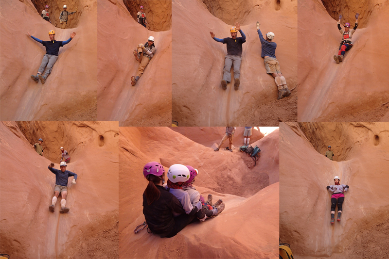 Fun times on the slide!
As you continue down
canyon of the slide the
canyon starts to open up
to a sandy wash and the
walls will begin to
drop. Continue
walking about 500
or 600 feet down canyon
to where the LDC wall
provides and easy ramp
to walk up the LDC
(east) side of the
canyon (yEgypt1Bt).
The Exit:
From the
bottom of the ramp up
out of the canyon on the
LDC (east) side
(yEgypt1Bt), walk up the
slickrock ramp out of
the canyon.
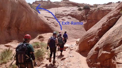 Exit ramp up out of the bottom end of the canyon on the LDC side.
As you start east up the
slickrock ramp look to
the left (north) to note
a sandstone peak about
500 feet away.
Route find your way up
to that peak by rim
walking north up canyon
a couple hundred feet
then route finding your
way up east up the ridge
toward that peak.
When you get up to what
was visually the high
point of the peak
(wEgypt1-RP2) when viewed
from down in the wash
most of the elevation
gain of the exit is done
and you are almost up on
the mesa top. et over to and up on
the dirt mesa top.
Just before getting up
onto the dirt mesa top
will be an easy upclimb
/ scramble of a few feet
(wEgyptRP3).
After getting up onto
the dirt covered flat
and wide open mesa top
(wEgypt1-RP3), Walk
northeast about 0.6
miles following social
trails that pretty much
rim walk back to the
head of the canyon and
where you parked the
car.
When you get back to the
head of the canyon take
a moment to go over and
retrieve any webbing you
may have left at the
head to rap in and walk
across the road to your
car (pkEgypt1).
Downloadable GPX files
available at
BG-Gear Store
(easier than manual entry and a great way to support
Bluugnome).
Waypoint naming convention and map symbol information can be found on the Glossary page.
Elevations are approximate.
BEFORE
manually entering coordinates set your system to WGS84 datum and Lat/Lon hddd.ddddd° coordinate format.
Inconsistent datum's and coordinate formats will result in location errors.
Click to show / expand the list of waypoints below........
| Egypt 1 (1) - Drive to Trailhead |
- extHoleInRock
Lat/Lon (WGS84): N 37.72769
W -111.53143
Elev: NaN Feet
Turn off to Hole-In-The-Rock road from Hwy 12.
- extEgypt
Lat/Lon (WGS84): N 37.54114
W -111.36176
Elev: 5,279 Feet
Turn off to the Egypt Road to the east (left on the drive in on Hole in the Rock road..
- EgyptDP-01
Lat/Lon (WGS84): N 37.56107
W -111.30718
Elev: 4,924 Feet
Egypt Road crosses over Twentyfive Mile Wash. Generally in good condition but may be a little difficult to get back up the hill on the drive back to the Hole in the Rock road. The hill is steep up out of the wash and a 2WD vehicle will need a little speed which is difficult since crossing the wash can be rough.
- pkEgypt1
Lat/Lon (WGS84): N 37.57269
W -111.25778
Elev: 5,270 Feet
Park here to start the Egypt 1 route.
|
| Egypt 1 (2) - Canyon and Exit |
- pkEgypt1
Lat/Lon (WGS84): N 37.57269
W -111.25778
Elev: 5,270 Feet
Park here to start the Egypt 1 route.
- yEgypt1Tp
Lat/Lon (WGS84): N 37.57233
W -111.25769
Elev: 5,260 Feet
Top entry Egypt 1. Can downclimb about 30 feet on the RDC side with a moderately difficult downclimb to enter the canyon. Or you can set up a rappel from the rim on a nearby boulder. If you set an anchor please retrieve the anchor after you complete the canyon.
- wEgypt1-RP1
Lat/Lon (WGS84): N 37.56853
W -111.26134
Elev: NaN Feet
This spot is the first of 4 significant drops in the canyon.
1st drop of significance is at this location and is a downclimb of about 15 feet over a large boulder. An anchor can be set from chokestones at the top of the boulder to rappel the drop or can be downclimbed by those with good downclimbing skills. You can provide a meat anchor for all but the last who can downclimb the drop.
2nd drop of significance is a drop of about 15 feet which is anchored from a deadman anchor. This drop may be downclimbed but would be sketchy and a very fast slide if you lost control. This drop is best done using the anchor to rappel or as a handline to assist with the downclimb.
3rd drop of significance is a drop of about 20 feet which is also anchored from a deadman anchor. This drop can be downclimbed with a partner assist by giving a handline to the first down and those at the bottom assisting the last person. As you downclimb there is a ledge on the LDC side that can be used to make things easier. If your group does not have good partner assist skills it may be best to rappel this drop.
4th drop of significance is a fun slide of about 20 feet! You will know the slide when you see it! If there is no water at the bottom of this drop the slide is steep enough that you gain a quick fun speed down it but still slow enough to provide a safe landing at the bottom. The slide is easy to upclimb and do over and over if you like. If you're in a playful mood this slide may fit the bill for quite a few minutes of entertainment. Ask me how I know this.
- yEgypt1Bt
Lat/Lon (WGS84): N 37.56277
W -111.26265
Elev: 4,940 Feet
Egypt 1 - bottom exit. LDC (east) wall has a gentle slope in this location allowing and easy walk up out of the canyon on the LDC side.
- wEgypt1-RP2
Lat/Lon (WGS84): N 37.56423
W -111.26252
Elev: NaN Feet
This is what was visually seen as the high point from down in the wash. At this point most of the elevation gain for the exit is done and you are almost on the mesa top. Continue northeast about 350 feet to get over to the mesa top.
- wEgypt1-RP3
Lat/Lon (WGS84): N 37.56482
W -111.26189
Elev: 5,182 Feet
Short easy upclimb / scramble here as you go from slickrock up onto the dirt mesa top. Walk northeast about 0.6 miles following social trails that pretty much rim walk back to the head of the canyon and where you parked the car.
|