Canyoneering Route Description
Bown Eye Canyon - 3A(B) III
Escalante National Monument, Utah.
2018-05-05, 7 people, 1 Day (Travel time in route 7.1 hours)

Time Required - 7 - 9 hours
Distance - 8.1 miles Total, 0.3 miles Technical
Rappels - 5 Rappels, Longest Rappel 80 feet.
Longest vertical drop is less but one rap can use 80 feet of
rope travel.
Elevation Range -
5475 - 6380 Feet
Shuttle Required - No Vehicle - Passenger,
if bad road conditions High Clearance
Permit Required - No
Bown Bottom Slot - non-technical
If adding a
trip down Bown Bottom Slot add
the below time and mileages
Added Time - 1 hour
Added
Distance - 0.8 miles
Rappelling and anchor gear, Ropes and or pull cords for rappels up
to 80 feet and 50 feet of 1 inch webbing just in case.
Sandtrap is recommended for one of the rappels but a rock anchor
could be built. Wet
suits generally not needed but may be worth it in cold weather for
the occasional dunk.
The Big Bown Bench Canyons are located on to of, well, Big
Bown Bench. To gain access to the canyons you will need to get up onto Big Bown
Bench where you can then navigate to the head of whichever fork you choose.
After completing the the technical portion of the canyon you will still be on
the mesa and will need to route find back to the approach ravine to get back
down off of Big Bown Bench.
On a solo hike to scout approach to the
Big Bown Canyons I was able to get the heads of the slots, walk through Bown
Bottom Slot, pear into the bottom of Bown Eye Canyon and walk up the lower
portion of Bown Star which had a super pretty subway at the bottom. Judging from what I saw in
person and from what I could see on Google Earth I thought the double forked
slot would be the best of the bunch so I called it Bown Star. The slot just
to the south that dumps into Bown Star also caught my eye so I called it
Bown Eye. The non-technical slot farther down the wash was dubbed Bown
Bottom.
The Big Bown Bench Canyons offer a few upper technical
forks with about 0.7 miles of wash below leading down to a lower
non-technical but pretty slot called Bown Bottom Slot. One can easily
descend any of the upper forks and exit right after or continue down to and
through Bown Bottom Slot. Due to forgiving terrain above it is also
possible to escape in places and circle around to redo portions of canyon or
mix and match forks in a number of ways. With so may possible options
the description may appear to bounce around a bit. If you take the
time to look at the maps and familiarize yourself with the layout of them,
the descriptions / route choics will make a lot more sense.
The ravine used to get up onto Big Bown Bench is also
used to exit down from Big Bown Bench. Scrambling up the ravine is straight
forward and easy. Once at the top of the ravine, you will scramble up steep
slick rock for about 200 feet to reach rolling desert on the mesa top. The
steep section has many ledges and is well featured making the scramble
overall easy with multiple ways to scramble up. This same section can be
difficult to route find and scramble down in the dark, so returning before
sunset is a good idea.
A GPS is highly recommended. The terrain across the
mesa is pretty forgiving of route finding choices but has few landmarks that
are helpful. The GPS is highly recommended for returning to the approach /
exit ravine. There are no obvious landmarks to guide you back to the top of
the ravine and most of the area along the edge of the mesa looks the same.
If you do not have anything guiding you back to the top of the approach /
exit ravine, you could find your self wandering around for a long time
looking for the way down.
The A(B) water rating is because portions of Bown Eye
have the potential to hold wast-ish deep water if recent rains have filled
it. A few spots could hold chest or swim depth water if recently rained on.
Most of the canyon appears to either not get a lot of water or drains
rapidly making the water exposure minimal. The last couple hundred feet of
canyon however does appear to hold water well and will likley have waist to
chest deep water in a few spots. During cold days a wet suit may be helpful
for those occasional spots of water. In moderate to warmer times of the year
a fast dunk here and there can be very welcome and refreshing to prepare you
for the hike out. It is difficult to say if it would be worth hauling the
weight of a wet suit on this route except in cold weather.
After Canyon Exit Options:
Exit
option one, is to exit the wash shortly down stream of Bown Star or Bown Eye
Canyons and travel a short distance up Bown Winkle Canyon where you can then
scramble up out of Bown Winkle to the rim and route find across the mesa
back to the approach ravine.
Exit option two, is to continue down the main wash
below Bown Star for about 0.7 miles to the top of a lower slot called Bown
Bottom Slot. Then play through the non-technical Bown Bottom Slot after
which you can exit up
from the end of the slot up to the mesa then route find your way back to the
exit ravine.
Bown Bottom Slot is about 0.7 miles down stream of the
upper forks (Bown Star right and left forks and Bown Eye). Bown Bottom is a
scenic non-technical slot about 0.3 mile long. The start of the slot has
three drops of about 4 to 6 feet each and the remainder is a narrow
walk-through slot with a couple long scenic narrow sections worth checking
out.
Note:
Also in Bown Bottom
Slot is a stick stuck between the walls
that you will need to duck under. Please leave this stick in place as it is
interesting for others to see. The stick has found its place between the
walls where it rocks back and forth easily with wind or water flow but does
not dislodge. The RDC side has even drilled a hole in the wall from its
motion. Please leave it here for others to muse over later. Give it a push
and watch it rock back and forth. Oddly satisfying.
General Canyon Thoughts:
The upper
portions of Bown Eye Canyon is a series of open and closed sections with
rappels and downclimbs pretty evenly spread along the way. The lower section
has a deep narrow slot that is very scenic and fun to play through as it
winds its way down but only lasts for about 100 feet. The winding a twisting
walls in this short slot sometimes feel like a tightly curved playground
slide with a few shallow potholes to play through. The final portion of the
canyon will likely have a couple of chest deep wades with short easy
downclimbs.
Route Suggestion:
After making a
few trips to the area I would recommend combining routes to see all the good
bits in the system while making for a reasonable length day. The route I
would recommend would be to go down the Left Fork of Bown Star Canyon, hike down the wash
about 600 feet to where you can scramble up steep slick rock on the LDC
(south) side to a wide slick rock bench running east up the south side of
Bown Eye Canyon. After walking the bench, walk down into Bown Eye and descend.
Then follow the exit
route out of the area back to the cars.
If for some reason you feel you
wanted more out of the day, you could then walk down to and through Bown Bottom Slot then exiting after.
To get to the Trailhead
From the town of Boulder Utah turn off of highway 12 onto the
Burr Trail Road. Follow the Burr Trail Road east for about
18.4 miles to an exit to a dirt road on the right (south) which
is the Wolverine Loop Road (extWolverine1).
Turn right (south) onto the Wolverine Loop Road and follow it
south about 5.6 miles to the a large junction (ExHorseCyn) where
the Horse Canyon road branches off to the right (west).
From the junction of Horse Canyon Road (ExHorseCyn), stay left
and continue on the Wolverine Loop road. About 4.6 miles
from the junction is a turn off (extWolverineTH) on the right
(west) to a short spur road for the Wolverine Creek Trailhead.
From the Wolverine Creek Turn off (extWolverineTH) stay straight
/ left on the Wolverine Loop Road and drive about 2.7 miles to
the turn off on right (exLilDeathHlw) for the Little Death
Hollow Trailhead. Turn right (south) and drive about 200
feet to the Little Death Hollow Trailhead (tLilDeathHlw) and
park. There is room for a quite a few cars here.
Note:
The hike in is down a drainage sometimes
referred to as Little
Death Hollow but on maps
is usually labeled as
Death Hollow. To avoid
confusion it is good to
be aware that this is a
different drainage from
the Death Hollow about
17 miles west of here
near the town of
Escalante.
To leave the Exit Vehicle / Escape Pod
No exit vehicle is needed. This is done as a loop route.
GPS coordinate information listed at the bottom. For information about waypoint naming and map symbols, refer to the
Glossary page.

Click the links for maps of the route.
Map of the entire route and system.
Map of a zoomed in portion of the approach.
Map of the routes on the mesa.
Map of the Canyon.
Map of Bown Bottom Slot and exit from.
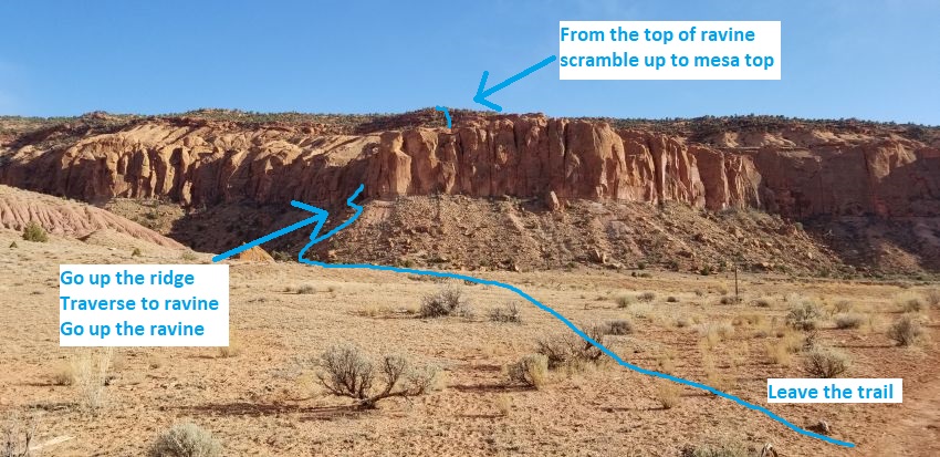
The Approach:
From the trailhead (tLilDeathHlw)
walk southwest down the
huge wide open wash
following trails.
About 1 mile to a large
boulder on the left side
of the trail
(jHolyCow-Apr).
Continue on the trail
about 800 feet after
passing the large
boulder to a spot with
no distinct landmark (jBigBownApr).
This spot is after the
trail crosses over the
wash twice as it a sharp
bend in the wash.
To continue the Big Bown
Bench approach, leave
the trail and hike south
across easy terrain for
0.3 miles to the Big
Bown approach ravine.
 View to the
approach / exit ravine for Big Bown Bench, viewed from the Little Death
Hollow trail.
View to the
approach / exit ravine for Big Bown Bench, viewed from the Little Death
Hollow trail.
From the bottom of the
steep dirt and rock
slopes up to the ravine
(BigBown01) travel is
easiest up the ridge
rather than directly up
under the ravine. Once
at the cliff band it is
easy to traverse over
and into the ravine.
Once at the bottom of
the ravine (BigBown02)
scramble up over
boulders into the
ravine.
About 100 feet into the
ravine is a large house
size boulder (BigBown03)
blocking the ravine.
Walk under the boulder
into a chamber in the
boulder debris and
continue scrambling up
the ravine into a
vegetated section.
Follow up the left
(southeast) side of the
ravine as it splits a
little farther up.
Scramble about 400 feet
up to the top of the
ravine (BigBown04).
Note:
When scrambling up
under the huge boulders
you will scramble over a
large rock with old
steps carved in it. It
appears this rock has
fallen from above and
was once part of a route
with carved steps that
has since fallen into
the ravine.
At the top of the ravine
(BigBown04) turn left
(south) and scramble up
the steep slickrock for
about 200 feet to get up
onto rolling desert on
the mesa top. This
section is steep but
ledges and features
where you can choose one
a few ways to scramble
up through it. This
section would be
difficult to route find
your way back down in
the dark so returning
before sunset is a good
idea.
Once above the steep
slickrock (BigBown05)
continue south about 400
feet up various dirt and
rock ledges to where the
terrain becomes gently
sloped.
As the terrain
transitions from steep
dirt and rock ledges to
more gentle terrain
(BigBown06) turn left
(east) and follow
roughly along the top of
the wide sandy ridge.
The ridge is very wide
and may not feel like a
ridge.
About 0.5 miles farther
is very wide sandy
saddle (BigBown07sdl)
just after passing a
minor peak. Continue
east about 0.3 miles to
the next wide saddle.
At the next wide saddle
(BigBown08sdl) continue
east across the saddle
the contour right
(south) following the
natural line along the
base of slopes under a
cliff band.
About 0.25 miles farther
the route starts around
a point (BigBown09) but
still on ledges contours
around steep slopes.
Route find east about
400 feet slowly working
your way down to a
weakness where you can
scramble down minor
ledges.
From the weakness
(BigBown10) scramble
southeast down minor
ledges and walk about
750 feet down into the
left fork of Bown Star
Canyon (yBownStarLFTp).
Navigation /
Route Description
Choice:
If
you choose to go down
the Left Fork of Bown
Star Canyon, you would
walk southwest from here
down the left fork.
To continue to the Right
Fork of Bown Star Canyon
scramble up the slope on
the southeast side for
about 400 feet up to the
crest of a ridge.
From the crest of the
ridge (BigBown11) route
find southeast about 650
feet down slopes and
minor ledges down into
the Right Fork of Bown
Star (yBownStarRFTp).
Navigation /
Route Description
Choice:
If
you choose to go down
the Right Fork of Bown
Star Canyon, you would
walk southwest from here
down the left fork.
To continuing
to Bown Eye Canyon, scramble up the
slope on the southeast
side for about 500 feet
to the top out on a
ridge (BigBown12).
Continue south about 600
feet down the slope into
the wash below
scrambling down a few
minor ledges.
Once down in the wash
above Bown Eye Canyon (jBownEye)
turn right and walk
southwest down the dirt
wash with the occasional
slick rock section.
About 0.27 miles down
the wash is a shelf
(BownEye01) of about 15
feet in the Bown Eye
drainage that is easily
bypassed on the RDC side
scrambling down a steep
dirt slope. Continue
down canyon with the
occasional minor drop
for about 950 feet to a
large drop down rolling
slick rock (yBownEyeTp).
The Canyoneering / Technical Section:
From the large
bulbous drop down
rolling sloped slickrock
(yBownEyeTp) scramble
down the sloped slick
rock drop and walk about
100 feet over to rap 1.
Note:
If approaching
from the bottom via the
ledge along the LDC
(south) side you can
easily walk / scramble
down to the canyon here.
Rap 1 (dBownEyeR1)
anchored from a tree on
the RDC side about 10
feet back and drops
about 30 feet.
About 80 feet down
canyon is an easy stem
style downclimb
(BownEye02) of about 8
feet into a short slot.
Continuing down canyon
is mostly easy walking
with a few spots to
galumph though.
Almost 200 feet down
canyon is a downclimb
(BownEye03) of about 8
feet that is easily done
with partner assist.
Shortly down canyon is a
downclimb (BownEye04) of
about 8 feet that is
easily done with partner
assist. Optionally this
drop can be bypassed by
carefully traversing the
RDC side along steep
slick rock. The bypass
is spicy but works well
for those not wanting to
get wet if there happens
to be water at the
bottom of the drop.
Shortly down canyon is
rap 2.
Rap 2 (dBownEyeR2)
anchored from a tree
about 15 feet back and
drops about 12 feet. The
upper portion of the
rappel is down a narrow
slot that can be
downclimbed with the
lower portion being
vertical and under cut
about 6 feet. With team
work this rappel could
be downclimbed with
aggressive partner
assist. At the bottom of
this rap is an arch at
the canyon floor to
crawl under giving way
to easy walking.
Rap 3 is a little over
100 feet down canyon.
Note:
You can easily
escape the canyon here
on the RDC (north) side.
Rap 3 (dBownEyeR3)
anchored from a tree
about 25 feet back and
drops over two stages
using about 80 feet of
rope from anchor to the
bottom. The first stage
drops about 10 feet and
could be downclimbed
with partner assist into
a narrow section leading
over to the second stage
that drops vertically
about 15 feet into an
open area. A
little over 100 feet
down canyon is rap 4.
Rap 4 (dBownEyeR4)
anchored using a
Sandtrap and drops about
15 feet and overhung.
Shortly after this rap
is a downclimb of about
6 feet into a very short
slot which then opens up
to wide easy walking
vegetated wash.
Rap 5 is about 250 feet
down canyon.
Rap 5 (dBownEyeR5)
anchored from a tree
about 10 feet back and
drops about 40 feet down
a vertical wall into
what feels like deeper
canyon than the other
raps felt like.
About 130 feet down
canyon is the upper end
of (BownEye05) a deep
narrow slot about 100
feet long with winding
and twisting walls that
give the in the belly of
the beast feel. Starting
into the slot requires a
galumph down canyon to
go over a large log
where you then stem down
about 15 feet to the
bottom of the slot. This
slot is very fun as it
winds down through the
sandstone with winding a
twisting walls that
sometimes feel like a
tightly curved
playground slide with a
few shallow potholes to
play through.
From the exit of the
narrow slot (BownEye06)
continue down canyon has
a couple easy downclimbs
of about 5 feet into
pools that can hold
chest deep water.
Near the end of the
canyon (yBownEye-Bt) is
a easy downclimb of
about 10 feet and is the
last mandatory drop in
the canyon. There are
two other drops just
after this that are
easily bypassed on the
LDC side where you then
walk down to the wash
and to the end of this
drainage where it meets
Bown Star Canyon (yBownStarBt).
Exit Option 1 - From
just after Bown Star and
Bown Eye Canyons:
From the
bottom of Bown Star
Canyon (yBownStarBt)
follow the wash about
0.3 miles to where the
bottom of Bown Winkle
joins in from RDC
(north).
Note:
About 600 feet down the
wash after the
confluence of Bown Star
and Bown Eye canyons is
where you can look for a
way to scramble up onto
the LDC side to a wide
slick rock bench.
That bench can be walked
up along the south side
of Bown Eye Canyon where
you can walk into the
head. This route
makes it possible to
quickly access and go
down Bown Eye Canyon
after getting to teh
bottom of Bown Star
Canyon. This combo
makes a for a great
length day and sees the
best portions of the
system.
From the bottom of Bown
Winkle (yBownWinkleBt)
turn right and walk
north up the bottom of
Bown Winkle.
About 200 feet up canyon
is a drop
(BownWrinkle22) of about
30 feet over a series of
potholes that is easily
bypassed LDC/RUC.
Bypass the drop and
continue up the wash.
About 450 feet up the
wash is a very short
narrow spot
(BownWrinkle21) with a
short easy scramble up
or down. Scramble
up the short drop and
walk up canyon about 120
feet to the next narrow
section that is longer
and tighter.
At the lower end of the
next narrow section
(BownWrinkle20E)
scramble up the left
(northwest - LUC/RDC)
side route finding up a
steep slickrock bowl.
Note:
If you were to try
to continue up the wash
past the exit point you
would need to galumph
about 8 feet off the
deck to get through the
100 foot long narrow
section.
Route finding about 250
feet up the slickrock
bowl leads to a weakness
(BigBown20) where you
can scramble up to the
gentler dirt slopes.
Once on the rim veer
right and follow the
wide ridge northeast
about 0.5 miles to where
you can cross a large
drainage along a shelf
(BigBown21).
After crossing the
drainage route find
northwest about 520 feet
to a wide sandy saddle
(BigBown07sdl).
This is the same saddle
you were at on the
approach.
At the saddle
(BigBown07sdl) turn left
and walk west about 0.5
miles to where you can
start down (BigBown06)
toward the exit ravine.
Walk about 425 feet down
dirt slopes to the top
of steep slickrock
(BigBown05) leading down
to the exit ravine.
Route find about 180
feet down to the top of
the ravine (BigBown04).
Turn right and scramble
down the ravine and
reverse the approach
hike back to the Little
Death Hollow trailhead (tLilDeathHlw).
Continuing down
to and through Bown
Bottom Slot:
From the bottom of Bown
Star Canyon (yBownStarBt)
follow down the main
wash for about 0.7 miles
to the top of Bown
Bottom Slot where it
gets narrow / skinny.
At the top of Bown
Bottom Slot (BownBottomTp)
is a a drop of about 6
feet down into a sandy
hole that can hold
shallow water after
recent rains. Just after
this drop are two more
drops of about 4 feet
each. The remainder of
this lower canyon is a
narrow walk through slot
with a couple of very
pretty sections worth
seeing. The first
section of this slot has
three large boulders
wedged between the walls
that you walk under.
About 500 feet down
canyon is a pothole side
drainage (BownBottom06)
that drops in from LDC
(east). If desired you
can walk / scramble up
the side of this
drainage to have a look
around the area. Down
canyon of this side
drainage is a very
pretty narrow section
about 300 feet long with
winding sculpted walls.
About 850 feet down
canyon is a drop
(BownBottom07) of about
10 feet that is easily
bypassed on the RDC
side.
Shortly after the
bypassed drop, Bown
Bottom Slot ends where
it widens out to wide
wash (yBownBottomBt).
The Exit - From
the bottom of Bown
Bottom Slot:
From the
lower end of Bown Bottom
Slot (yBownBottomBt)
walk / scramble up the
RDC (north) side.
About 200 feet up you
may find rocks stacked
(BownBottom08) that
appear to be a cairn.
To continue the exit
route find about 100
feet northwest up minor
shelves up to open
desert slopes going up
to the northwest.
Once up open desert
slopes (BownBottom09),
route find northwest
about 0.2 miles up onto
a very wide gentle
ridge.
Once up on top of the
gentle ridge
(BownBottom10), veer
right (northeast) and
follow up the wide ridge
for about 800 feet to a
minor peak along the
ridge.
From the minor peak
(BownBottom11), continue
northeast along the wide
ridge about 0.35 miles
to another minor peak
along the ridge.
From the next minor peak
(BownBottom12), continue
northeast along the wide
ridge for about 850 feet
to where you can veer
left and travel
northwest contouring
around a drainage that
is now wide and shallow.
As you contour around
the wide shallow
drainage (BownBottom13)
continue northwest about
0.3 miles to contour
around another drainage.
This next drainage you
contour around
(BownBottom14) a shelf
in a drainage where
travel is easy. Continue
north to where you can
start walking down dirt
slopes toward the
approach / exit ravine
(BigBown06).
Walk about 425 feet down
dirt slopes to the top
of steep slickrock
(BigBown05) leading down
to the exit ravine.
Route find about 180
feet down to the top of
the ravine (BigBown04).
Turn right and scramble
down the ravine and
reverse the approach
hike back to the Little
Death Hollow trailhead (tLilDeathHlw).
Downloadable GPX files
available at
BG-Gear Store
(easier than manual entry and a great way to support
Bluugnome).
Waypoint naming convention and map symbol information can be found on the Glossary page.
Elevations are approximate.
BEFORE
manually entering coordinates set your system to WGS84 datum and Lat/Lon hddd.ddddd° coordinate format.
Inconsistent datum's and coordinate formats will result in location errors.
Click to show / expand the list of waypoints below........
| Bown Eye (1) - Approach to Bown Eye |
- tLilDeathHlw
Lat/Lon (WGS84): N 37.78402
W -111.18060
Elev: 5,550 Feet
Trailhead for Little Death Hollow. Space for quite a few cars to park.
The drainage down from here is sometimes referred to as Little Death Hollow but on maps is usually labeled as Death Hollow. To avoid confusion it is good to be aware that this is a different drainage from the Death Hollow about 17 miles west of here near the town of Escalante.
- jHolyCow-Apr
Lat/Lon (WGS84): N 37.77332
W -111.19234
Elev: 5,480 Feet
A spot on the trail just past a very large boulder sitting next to the trail. From here you can get a visual on the approach route. Leave the trail here and hike about 900 feet west across the desert toward the rubble filled slope at the base of the cliff band. Looking west from here note a large light colored arch-like indention in the cliff band then note the saddle just to the left (south) of that. Just below that saddle is a ramp leading up the cliff side to a small patch of vegetation. Route find your way to that ramp.
A large boulder filled ravine can be seen to the north from here and can optionally be used to approach Holy Cow but will add distance and time to the route as well as require scrambling some sketchy sections of steep slickrock.
- jBigBownApr
Lat/Lon (WGS84): N 37.77156
W -111.19418
Elev: 5,475 Feet
Leave main trail here to follow the approach up to Big Bown Bench. This spot with no distinct landmark and is about 800 feet after passing the large boulder along the trail and is after the trail crosses over the wash twice as it a sharp bend in the wash.
To continue the Big Bown Bench approach, leave the trail and hike south across easy terrain for 0.3 miles to the Big Bown approach ravine.
- BigBown01
Lat/Lon (WGS84): N 37.76747
W -111.19225
Elev: NaN Feet
Start up the steep dirt and rock slope up toward a ravine. Travel is easiest up the ridge rather than directly up under the ravine. Once at the cliff band it is easy to traverse over and into the ravine.
- BigBown02
Lat/Lon (WGS84): N 37.76659
W -111.19285
Elev: NaN Feet
Bottom of the ravine to scramble up onto Big Bown Bench.
- BigBown03
Lat/Lon (WGS84): N 37.76640
W -111.19319
Elev: NaN Feet
Large house size boulder blocking the ravine. Walk under the boulder into a chamber in the boulder debris and continue scrambling up the ravine into a vegetated section. Follow up the left (southeast) side of the ravine as it splits a little farther up.
Note: When scrambling up under the huge boulders you will scramble over a large rock with old steps carved in it. It appears this rock has fallen from above and was once part of a route with carved steps that has since fallen into the ravine.
- BigBown04
Lat/Lon (WGS84): N 37.76562
W -111.19416
Elev: 5,940 Feet
Top of the ravine. Turn left (south) and scramble up the steep slickrock for about 200 feet to get up onto rolling desert on the mesa top. This section is steep but ledges and features where you can choose one a few ways to scramble up through it. This section would be difficult to route find your way back down in the dark so returning before sunset is a good idea.
- BigBown05
Lat/Lon (WGS84): N 37.76527
W -111.19383
Elev: NaN Feet
Top of the steep slickrock above the approach ravine.
On approach continue south about 400 feet up various dirt and rock ledges to where the terrain becomes gently sloped.
On exit, scramble down the slickrock ledges to the head of the ravine.
- BigBown06
Lat/Lon (WGS84): N 37.76426
W -111.19311
Elev: NaN Feet
Terrain transitions from steep dirt and rock ledges to more gentle terrain.
On approach to the Big Bown Canyons turn left (east) and follow roughly along the top of the wide sandy ridge. The ridge is very wide and may not feel like a ridge.
On exit, route find your way north down the slopes.
- BigBown07sdl
Lat/Lon (WGS84): N 37.76270
W -111.18352
Elev: 6,230 Feet
Very wide sandy saddle.
On Approach to Big Bown Canyons this is just after passing a minor peak. Continue east about 0.3 miles to the next wide saddle.
On exit turn left and walk west about 0.5 miles to where you can start down toward the exit ravine.
- BigBown08sdl
Lat/Lon (WGS84): N 37.76200
W -111.17896
Elev: NaN Feet
Wide saddle. Continue east across the saddle the contour right (south) following the natural line along the base of slopes under a cliff band.
- BigBown09
Lat/Lon (WGS84): N 37.75964
W -111.17604
Elev: 6,290 Feet
Route starts around a point but still on ledges contouring around steep slopes. Route find east about 400 feet slowly working your way down to a weakness where you can scramble down minor ledges.
- BigBown10
Lat/Lon (WGS84): N 37.75979
W -111.17450
Elev: NaN Feet
Scramble southeast down minor ledges and walk about 750 feet down into the left fork of Bown Star Canyon.
- yBownStarLFTp
Lat/Lon (WGS84): N 37.75878
W -111.17234
Elev: 6,170 Feet
Approach route reaches the left fork of Bown Star Canyon.
To go down the left fork, walk southwest down the wash.
To continue to the right fork of Bown Star or to Bown Eye Canyon, scramble up the slope on the southeast side for about 400 feet up to the crest of a ridge.
Note: If you drop into the wash about 500 feet up canyon of here you will find a couple easy to bypass short drops.
- BigBown11
Lat/Lon (WGS84): N 37.75805
W -111.17118
Elev: NaN Feet
Top out on a ridge between the heads of right and left forks of Bown Star Canyon.
To continue to the left fork of Bown Star, route find southeast about 650 feet down slopes and minor ledges down into the Right Fork of Bown Star.
- yBownStarRFTp
Lat/Lon (WGS84): N 37.75708
W -111.16940
Elev: 6,170 Feet
Approach route reaches the right fork of Bown Star Canyon. A drop in the wash here is bypassed on the RDC side down steep slopes.
To go down the right fork, walk southwest down the wash.
To continue to Bown Eye Canyon, scramble up the slope on the southeast side for about 500 feet to the top out on a ridge.
Note: If you drop into the wash about 250 feet up canyon of here you will find a couple easy to bypass short drops.
- BigBown12
Lat/Lon (WGS84): N 37.75578
W -111.16910
Elev: NaN Feet
Top out on a ridge between Right Fork of Bown Star and Bown Eye Canyons. Continue south about 600 feet down the slope into the wash below scrambling down a few minor ledges.
- jBownEye
Lat/Lon (WGS84): N 37.75430
W -111.16852
Elev: NaN Feet
Route gets to Bown Eye Canyon. Turn right and walk southwest down the dirt wash with the occasional slick rock section.
- BownEye01
Lat/Lon (WGS84): N 37.75178
W -111.17206
Elev: NaN Feet
Shelf of about 15 feet in the Bown Eye drainage that is easily bypassed on the RDC side scrambling down a steep dirt slope. Continue down canyon with the occasional minor drop for about 950 feet to a large drop down rolling slick rock.
- yBownEyeTp
Lat/Lon (WGS84): N 37.75118
W -111.17486
Elev: 6,040 Feet
Top of Bown Eye Canyon. Large bulbous drop down rolling slick rock. Scramble down the sloped slick rock drop and walk about 100 feet over to rap 1.
Note: If approaching from the bottom via the ledge along the LDC (south) side you can easily walk / scramble down to the canyon here.
|
| Bown Eye (2) - The Canyon |
- yBownEyeTp
Lat/Lon (WGS84): N 37.75118
W -111.17486
Elev: 6,040 Feet
Top of Bown Eye Canyon. Large bulbous drop down rolling slick rock. Scramble down the sloped slick rock drop and walk about 100 feet over to rap 1.
Note: If approaching from the bottom via the ledge along the LDC (south) side you can easily walk / scramble down to the canyon here.
- dBownEyeR1
Lat/Lon (WGS84): N 37.75120
W -111.17523
Elev: NaN Feet
Rap1 - Bown Eye Canyon. Anchored from a tree on the RDC side about 10 feet back and drops about 30 feet.
- BownEye02
Lat/Lon (WGS84): N 37.75127
W -111.17549
Elev: NaN Feet
Easy stem style downclimb of about 8 feet into a short slot. Continuing down canyon is mostly easy walking with a few spots to galumph though.
- BownEye03
Lat/Lon (WGS84): N 37.75144
W -111.17607
Elev: NaN Feet
Downclimb of about 8 feet that is easily done with partner assist.
- BownEye04
Lat/Lon (WGS84): N 37.75149
W -111.17627
Elev: NaN Feet
Downclimb of about 8 feet that is easily done with partner assist. Optionally this drop can be bypassed by carefully traversing the RDC side along steep slick rock. The bypass is spicy but works well for those not wanting to get wet if there happens to be water at the bottom of the drop.
- dBownEyeR2
Lat/Lon (WGS84): N 37.75153
W -111.17658
Elev: NaN Feet
Rap2 - Bown Eye Canyon. Anchored from a tree about 15 feet back and drops about 12 feet. The upper portion of the rappel is down a narrow slot that can be downclimbed with the lower portion being vertical and under cut about 6 feet. With team work this rappel could be downclimbed with aggressive partner assist. At the bottom of this rap is an arch at the canyon floor to crawl under giving way to easy walking.
Note: you can easily escape the canyon here on the RDC (north) side.
- dBownEyeR3
Lat/Lon (WGS84): N 37.75152
W -111.17703
Elev: NaN Feet
Rap3 - Bown Eye Canyon. Anchored from a tree about 25 feet back and drops over two stages using about 80 feet of rope from anchor to the bottom. The first stage drops about 10 feet and could be downclimbed with partner assist into a narrow section leading over to the second stage that drops vertically about 15 feet into an open area.
- dBownEyeR4
Lat/Lon (WGS84): N 37.75163
W -111.17746
Elev: NaN Feet
Rap 4 - Bown Eye Canyon. Anchored using a sandtrap and drops about 15 feet and overhung. Shortly after this rap is a downclimb of about 6 feet into a very short slot which then opens up to wide easy walking vegetated wash.
- dBownEyeR5
Lat/Lon (WGS84): N 37.75202
W -111.17813
Elev: NaN Feet
Rap 5 - Bown Eye Canyon. Anchored from a tree about 10 feet back and drops about 40 feet down a vertical wall into what feels like deeper canyon than the other raps felt like.
- BownEye05
Lat/Lon (WGS84): N 37.75210
W -111.17856
Elev: NaN Feet
Upper end of a deep narrow slot about 100 feet long with winding and twisting walls that give the in the belly of the beast feel. Starting into the slot requires a galumph down canyon to go over a large log where you then stem down about 15 feet to the bottom of the slot. This slot is very fun as it winds down through the sandstone with winding a twisting walls that sometimes feel like a tightly curved playground slide with a few shallow potholes to play through.
- BownEye06
Lat/Lon (WGS84): N 37.75217
W -111.17886
Elev: NaN Feet
End of the deep slot. Continuing down canyon is a couple easy downclimbs of about 5 feet into pools that can hold chest deep water.
- yBownEye-Bt
Lat/Lon (WGS84): N 37.75261
W -111.17938
Elev: 5,870 Feet
Easy downclimb of about 10 feet and is the last mandatory drop in the canyon. There are two other drops just after this that are easily bypassed on the LDC side where you then walk down to the wash and to the end of this drainage where it meets Bown Star Canyon.
- yBownStarBt
Lat/Lon (WGS84): N 37.75286
W -111.17982
Elev: NaN Feet
Confluence where Bown Star and Bown Eye canyons join with easy wash walking down canyon.
|
| Bown Eye (3) - Exit - down to Bown Winkle |
- yBownStarBt
Lat/Lon (WGS84): N 37.75286
W -111.17982
Elev: NaN Feet
Confluence where Bown Star and Bown Eye canyons join with easy wash walking down canyon.
- jBownEyeBotApr
Lat/Lon (WGS84): N 37.75290
W -111.18164
Elev: NaN Feet
Approximate location where you can scramble up steep slick rock up to the bench on the RDC (south) side. You can then walk that bencho east up along the south side of Bown Eye Canyon then walk into the head of the canyon.
- BownStar34EE
Lat/Lon (WGS84): N 37.75312
W -111.18335
Elev: NaN Feet
Spot where you can begin scrambling up steep slickrock on the RDC (north) side to get up to the slickrock bench running just below the rock and dirt cliff where you can contour your way up to re-enter the Left Fork of Bown Star Canyon just above the first rappel. No distinct landmark here.
- yBownWinkleBt
Lat/Lon (WGS84): N 37.75272
W -111.18525
Elev: NaN Feet
Bottom of Bown Winkle Canyon where it dumps into the main wash of Bown Star. To continue down to Bown Bottom Slot, continue west down the wash. To exit the area turn right and walk north up the bottom of Bown Winkle.
|
| Bown Eye (4) - Exit via Bown Winkle |
- yBownWinkleBt
Lat/Lon (WGS84): N 37.75272
W -111.18525
Elev: NaN Feet
Bottom of Bown Winkle Canyon where it dumps into the main wash of Bown Star. To continue down to Bown Bottom Slot, continue west down the wash. To exit the area turn right and walk north up the bottom of Bown Winkle.
- BownWrinkle22
Lat/Lon (WGS84): N 37.75321
W -111.18539
Elev: NaN Feet
Drop of about 30 feet over a series of potholes that is easily bypassed LDC/RUC.
- BownWrinkle21
Lat/Lon (WGS84): N 37.75436
W -111.18515
Elev: NaN Feet
Very short narrow spot with a short easy scramble up or down.
When exiting up from Bown Star or Bown Eye Canyons, scramble up the short drop and walk up canyon about 120 feet to the next narrow section that is longer and tighter.
- BownWrinkle20E
Lat/Lon (WGS84): N 37.75461
W -111.18480
Elev: NaN Feet
Down canyon end of a 100 foot long skinny section where galumphing about 8 feet off the deck would be required.
When exiting from Bown Star or Bown Eye Canyons, walk up the very steep slickrock bowl to the north RDC/LUC) and route find your way to the rim.
- BigBown20
Lat/Lon (WGS84): N 37.75481
W -111.18565
Elev: NaN Feet
Weakness allowing access to the rim above after walking up a very steep slickrock bowl up out of Bown Winkle Canyon. To exit the area veer right and follow the wide ridge northeast.
- BigBown21
Lat/Lon (WGS84): N 37.76148
W -111.18264
Elev: NaN Feet
When on exit from Bown Star or Bown Eye Canyons cross over a shelf in this drainage and route find northwest about 520 feet to a wide sandy saddle.
- BigBown07sdl
Lat/Lon (WGS84): N 37.76270
W -111.18352
Elev: 6,230 Feet
Very wide sandy saddle.
On Approach to Big Bown Canyons this is just after passing a minor peak. Continue east about 0.3 miles to the next wide saddle.
On exit turn left and walk west about 0.5 miles to where you can start down toward the exit ravine.
- BigBown06
Lat/Lon (WGS84): N 37.76426
W -111.19311
Elev: NaN Feet
Terrain transitions from steep dirt and rock ledges to more gentle terrain.
On approach to the Big Bown Canyons turn left (east) and follow roughly along the top of the wide sandy ridge. The ridge is very wide and may not feel like a ridge.
On exit, route find your way north down the slopes.
- BigBown05
Lat/Lon (WGS84): N 37.76527
W -111.19383
Elev: NaN Feet
Top of the steep slickrock above the approach ravine.
On approach continue south about 400 feet up various dirt and rock ledges to where the terrain becomes gently sloped.
On exit, scramble down the slickrock ledges to the head of the ravine.
- BigBown04
Lat/Lon (WGS84): N 37.76562
W -111.19416
Elev: 5,940 Feet
Top of the ravine. Turn left (south) and scramble up the steep slickrock for about 200 feet to get up onto rolling desert on the mesa top. This section is steep but ledges and features where you can choose one a few ways to scramble up through it. This section would be difficult to route find your way back down in the dark so returning before sunset is a good idea.
- BigBown03
Lat/Lon (WGS84): N 37.76640
W -111.19319
Elev: NaN Feet
Large house size boulder blocking the ravine. Walk under the boulder into a chamber in the boulder debris and continue scrambling up the ravine into a vegetated section. Follow up the left (southeast) side of the ravine as it splits a little farther up.
Note: When scrambling up under the huge boulders you will scramble over a large rock with old steps carved in it. It appears this rock has fallen from above and was once part of a route with carved steps that has since fallen into the ravine.
- BigBown02
Lat/Lon (WGS84): N 37.76659
W -111.19285
Elev: NaN Feet
Bottom of the ravine to scramble up onto Big Bown Bench.
- BigBown01
Lat/Lon (WGS84): N 37.76747
W -111.19225
Elev: NaN Feet
Start up the steep dirt and rock slope up toward a ravine. Travel is easiest up the ridge rather than directly up under the ravine. Once at the cliff band it is easy to traverse over and into the ravine.
- jBigBownApr
Lat/Lon (WGS84): N 37.77156
W -111.19418
Elev: 5,475 Feet
Leave main trail here to follow the approach up to Big Bown Bench. This spot with no distinct landmark and is about 800 feet after passing the large boulder along the trail and is after the trail crosses over the wash twice as it a sharp bend in the wash.
To continue the Big Bown Bench approach, leave the trail and hike south across easy terrain for 0.3 miles to the Big Bown approach ravine.
- jHolyCow-Apr
Lat/Lon (WGS84): N 37.77332
W -111.19234
Elev: 5,480 Feet
A spot on the trail just past a very large boulder sitting next to the trail. From here you can get a visual on the approach route. Leave the trail here and hike about 900 feet west across the desert toward the rubble filled slope at the base of the cliff band. Looking west from here note a large light colored arch-like indention in the cliff band then note the saddle just to the left (south) of that. Just below that saddle is a ramp leading up the cliff side to a small patch of vegetation. Route find your way to that ramp.
A large boulder filled ravine can be seen to the north from here and can optionally be used to approach Holy Cow but will add distance and time to the route as well as require scrambling some sketchy sections of steep slickrock.
- tLilDeathHlw
Lat/Lon (WGS84): N 37.78402
W -111.18060
Elev: 5,550 Feet
Trailhead for Little Death Hollow. Space for quite a few cars to park.
The drainage down from here is sometimes referred to as Little Death Hollow but on maps is usually labeled as Death Hollow. To avoid confusion it is good to be aware that this is a different drainage from the Death Hollow about 17 miles west of here near the town of Escalante.
|
| Bown Eye (5) - Down to and through Bown Bottom Slot |
- yBownWinkleBt
Lat/Lon (WGS84): N 37.75272
W -111.18525
Elev: NaN Feet
Bottom of Bown Winkle Canyon where it dumps into the main wash of Bown Star. To continue down to Bown Bottom Slot, continue west down the wash. To exit the area turn right and walk north up the bottom of Bown Winkle.
- BownBottom01
Lat/Lon (WGS84): N 37.75225
W -111.18579
Elev: NaN Feet
Short section of slickrock the water has cut a deep slot in. This is in a huge open sandy wash and would be easily missed if not strictly following the water course.
- BownBottom02EE
Lat/Lon (WGS84): N 37.75145
W -111.18777
Elev: NaN Feet
Can scramble north up slick rock to get up to rolling desert above.
- BownBottom03
Lat/Lon (WGS84): N 37.75063
W -111.18843
Elev: NaN Feet
Drainage drops in from RDC (north). Down canyon from here the canyon begins to get more narrow with vertical walls but still overall wide easy wash walking.
- BownBottom04EE
Lat/Lon (WGS84): N 37.75051
W -111.18928
Elev: NaN Feet
Can scramble up the RDC (north) side to rim walk down canyon along a wide slickrock shelf just above the canyon floor.
- BownBottom05
Lat/Lon (WGS84): N 37.74989
W -111.18974
Elev: NaN Feet
Huge boulder sitting in the middle of the wash.
- BownBottomTp
Lat/Lon (WGS84): N 37.74926
W -111.19033
Elev: 5,810 Feet
Top of Bown Bottom Slot and a drop of about 6 feet down into a sandy hole that can hold shallow water after recent rains. Just after this drop are two more drops of about 4 feet each. The remainder of this lower canyon is a narrow walk through slot with a couple of very pretty sections worth seeing. The first section of this slot has three large boulders wedged between the walls that you walk under.
- BownBottom06
Lat/Lon (WGS84): N 37.74805
W -111.19120
Elev: NaN Feet
Pothole side drainage drops in from LDC (east). If desired you can walk / scramble up the side of this drainage to have a look around the area. Down canyon of this side drainage is a very pretty narrow section about 300 feet long with winding sculpted walls.
- BownBottom07
Lat/Lon (WGS84): N 37.74672
W -111.19317
Elev: NaN Feet
Drop of about 10 feet that is easily bypassed on the RDC side.
- yBownBottomBt
Lat/Lon (WGS84): N 37.74651
W -111.19313
Elev: 5,760 Feet
Lower end of Bown Bottom Slot where it opens up to wash walking. To exit walk / scramble up the RDC (north) side.
|
| Bown Eye (6) - Exit from Bown Bottom |
- yBownBottomBt
Lat/Lon (WGS84): N 37.74651
W -111.19313
Elev: 5,760 Feet
Lower end of Bown Bottom Slot where it opens up to wash walking. To exit walk / scramble up the RDC (north) side.
- BownBottom08
Lat/Lon (WGS84): N 37.74684
W -111.19358
Elev: NaN Feet
Rocks stacked that appears to be a cairn. To exit route find about 100 feet northwest up minor shelves up to open desert slopes going up to the northwest.
- BownBottom09
Lat/Lon (WGS84): N 37.74695
W -111.19393
Elev: NaN Feet
Now on open desert slopes, route find northwest about 0.2 miles up onto a very wide gentle ridge.
- BownBottom10
Lat/Lon (WGS84): N 37.74929
W -111.19586
Elev: NaN Feet
On a wide gentle ridge, veer right (northeast) and follow up the wide ridge for about 800 feet to a minor peak along the ridge.
- BownBottom11
Lat/Lon (WGS84): N 37.75131
W -111.19421
Elev: NaN Feet
Minor peak along the ridge. Continue northeast along the wide ridge about 0.35 miles to another minor peak along the ridge.
- BownBottom12
Lat/Lon (WGS84): N 37.75620
W -111.19255
Elev: NaN Feet
Minor peak along the ridge. Continue northeast along the wide ridge for about 850 feet to where you can veer left and travel northwest contouring around a drainage that is now wide and shallow.
- BownBottom13
Lat/Lon (WGS84): N 37.75820
W -111.19069
Elev: NaN Feet
Veer left and contour around to travel northwest crossing a drainage that is now wide and shallow. Continue northwest about 0.3 miles to contour around another drainage.
- BownBottom14
Lat/Lon (WGS84): N 37.76222
W -111.19220
Elev: NaN Feet
Contour over a shelf in a drainage where travel is easy. Continue north to where you can start walking down dirt slopes toward the approach / exit ravine.
- BigBown06
Lat/Lon (WGS84): N 37.76426
W -111.19311
Elev: NaN Feet
Terrain transitions from steep dirt and rock ledges to more gentle terrain.
On approach to the Big Bown Canyons turn left (east) and follow roughly along the top of the wide sandy ridge. The ridge is very wide and may not feel like a ridge.
On exit, route find your way north down the slopes.
- BigBown05
Lat/Lon (WGS84): N 37.76527
W -111.19383
Elev: NaN Feet
Top of the steep slickrock above the approach ravine.
On approach continue south about 400 feet up various dirt and rock ledges to where the terrain becomes gently sloped.
On exit, scramble down the slickrock ledges to the head of the ravine.
- BigBown04
Lat/Lon (WGS84): N 37.76562
W -111.19416
Elev: 5,940 Feet
Top of the ravine. Turn left (south) and scramble up the steep slickrock for about 200 feet to get up onto rolling desert on the mesa top. This section is steep but ledges and features where you can choose one a few ways to scramble up through it. This section would be difficult to route find your way back down in the dark so returning before sunset is a good idea.
- BigBown03
Lat/Lon (WGS84): N 37.76640
W -111.19319
Elev: NaN Feet
Large house size boulder blocking the ravine. Walk under the boulder into a chamber in the boulder debris and continue scrambling up the ravine into a vegetated section. Follow up the left (southeast) side of the ravine as it splits a little farther up.
Note: When scrambling up under the huge boulders you will scramble over a large rock with old steps carved in it. It appears this rock has fallen from above and was once part of a route with carved steps that has since fallen into the ravine.
- BigBown02
Lat/Lon (WGS84): N 37.76659
W -111.19285
Elev: NaN Feet
Bottom of the ravine to scramble up onto Big Bown Bench.
- BigBown01
Lat/Lon (WGS84): N 37.76747
W -111.19225
Elev: NaN Feet
Start up the steep dirt and rock slope up toward a ravine. Travel is easiest up the ridge rather than directly up under the ravine. Once at the cliff band it is easy to traverse over and into the ravine.
- jBigBownApr
Lat/Lon (WGS84): N 37.77156
W -111.19418
Elev: 5,475 Feet
Leave main trail here to follow the approach up to Big Bown Bench. This spot with no distinct landmark and is about 800 feet after passing the large boulder along the trail and is after the trail crosses over the wash twice as it a sharp bend in the wash.
To continue the Big Bown Bench approach, leave the trail and hike south across easy terrain for 0.3 miles to the Big Bown approach ravine.
- jHolyCow-Apr
Lat/Lon (WGS84): N 37.77332
W -111.19234
Elev: 5,480 Feet
A spot on the trail just past a very large boulder sitting next to the trail. From here you can get a visual on the approach route. Leave the trail here and hike about 900 feet west across the desert toward the rubble filled slope at the base of the cliff band. Looking west from here note a large light colored arch-like indention in the cliff band then note the saddle just to the left (south) of that. Just below that saddle is a ramp leading up the cliff side to a small patch of vegetation. Route find your way to that ramp.
A large boulder filled ravine can be seen to the north from here and can optionally be used to approach Holy Cow but will add distance and time to the route as well as require scrambling some sketchy sections of steep slickrock.
- tLilDeathHlw
Lat/Lon (WGS84): N 37.78402
W -111.18060
Elev: 5,550 Feet
Trailhead for Little Death Hollow. Space for quite a few cars to park.
The drainage down from here is sometimes referred to as Little Death Hollow but on maps is usually labeled as Death Hollow. To avoid confusion it is good to be aware that this is a different drainage from the Death Hollow about 17 miles west of here near the town of Escalante.
|