Canyoneering Route Description
Vinegaroon Canyon - 3A II
Death Valley National Park,
California.
11-30-13, 8 people, 1 Day (Travel time in route 7.75 hours)

Time Required - 4 to 7 hours
Distance - 5.4 miles Total, 1.9 miles Technical
Rappels - 5 Rappels, Longest Rappel 85 feet.
Elevation Range - 1870 - 50 feet below sea
level Feet
Shuttle Required - Yes 10.9 Miles Vehicle -
Passenger
Permit Required - No
Rappelling and anchor gear, Ropes and or pull cords for rappels up
to 85 feet and 60 feet of 1 inch webbing for sling placement.
Vinegaroon Canyon is just north of and runs parallel to
Scorpion Canyon. Both canyons use the same trailhead and end up at the
same parking spot for the exit vehicle. The approach for Vinegaroon Canyon
uses the same approach as Scorpion Canyon. Shortly before reaching the
technical section of Scorpion the route leaves the Scorpion Canyon drainage to
gain access to a ridge that leads to the top of Vinegaroon Canyon.
The views from the ridge between Scorpion Canyon and
Vingaroon Canyon are amazing. There are 360 degree scenic views of the
area as well as birds eye views down over some very colorful sections.
Technically Scorpion Canyon and Vinegaroon Canyon are very similar and both
have long sections of scenic wash walking. So the main difference
between the two is the option to have incredible views while on the approach
ridge if you choose Vinegaroon Canyon over Scorpion Canyon.
The lower 0.7 miles of canyon are more deep and
corridor like than the upper section of the canyon and contains most of the
raps in the canyon and a lot of scrambling and downclimbs.
Like Scorpion Canyon, Vinegaroon Canyon requires a car
shuttle.
When we were there in Nov. 2013 it was a week after
some heavy rains. As a result a lot of salt was being leached out of
the rock as the water evaporated. This gave us the treat of some
sections with a coating of white salt that would soon blow away with wind
and dirt. A few of the pictures in the album from that date may look
like we had snow. It was not snow but was instead the salt.
Pretty cool but it wont always be there.
To get to the Trailhead
From the Junction of highway 190 and highway 178, drive south
east on highway 190 for 4.7 miles to the turn off for the Twenty
Mule Team road (ext-20Mule-In) on the right (south) side of the
highway. The Twenty Mule Team road is a dirt road that
runs for about 2.6 miles and comes back out to the highway a
little south of where you entered. Turn right (south) onto
the Twenty Mule Team road and drive 1.7 miles to a parking
turnout on the right (pkScorpion). This turnout is
just as you reach a sharp left hand bend in the road. Park
the entry vehicle here. Remember to go set an exit vehicle
as this route requires a shuttle.
To leave the Exit Vehicle / Escape Pod
From the Junction of highway 190 and highway 178 (Badwater
Road), drive south on highway 178 for 3.7 miles to a dirt road
(extDesoltnCyn) on the left (east). Turn left onto the
Desolation Canyon road and drive 0.5 miles east to the end of
the dirt road where there is a large parking area (tDesolationCyn).
Park the exit vehicle here.
GPS coordinate information listed at the bottom. For information about waypoint naming and map symbols, refer to the
Glossary page.

Click the links for maps of the route.
Map of the
entire route.
Map of the
approach.
Map of the technical
and exit sections.
The Approach:
The Approach:
From the parking spot (pkScorpion)
walk about 350 feet
north on the Twenty Mule
Team road to a large
wash (wScorpionRP01)
leaving the road and
traveling southwest.
Turn left and walk
southwest up the large
wide wash. About
700 feet from the road
the wash is wide and may
seem to have forks
coming in. Just
keep following straight
up southwest of what
feels like the main
wash.
About 0.28 miles up the
wash you may notice a
doorway shaped hole
(wScorpionRP02) in the
hillside on the left
(southeast) side.
There are a couple short
tunnels here. As a
general rule it is best
to do as the park
says.... Stay Out - Stay
Alive.
Another 650 feet
southwest up the
drainage is where the
wash begins to get a
little more narrow
(wScorpionRP03).
About 400 feet farther
the wash makes a left -
right jog
(wScorpionRP04) shortly
before getting to a more
wide open section of the
wash.
About 350 to 400 feet
farther will be a spot
to scramble up about 15
feet. Just after
the scramble up will be
a confluence of 3 forks
(wScorpionRP05).
From the confluence
travel southwest up the
left most fork.
Travel from here gets
steeper but is mostly an
easy walk up with an
occasional spot where
you might want to use
your hands for balance.
About 500 feet farther
is a narrow spot where
you need to scramble
about 15 feet up a steep
section (wScorpionRP06)
that also has a lot of
loose sand and gravel on
it.
Continue light
scrambling up a
moderately steep section
for about 200 feet until
you get to a more wide
open area
(wScorpionRP07) and easy
wash walking again.
There is a confluence
here of a few forks.
Travel up the left most
fork going southeast
then shortly after
turning right to travel
southwest again.
Note:
From this confluence you
can see a white
conglomerate cliff band
ahead to the west.
What you will be trying
to do from here is
travel up to the left
(south) side of the
cliff band.
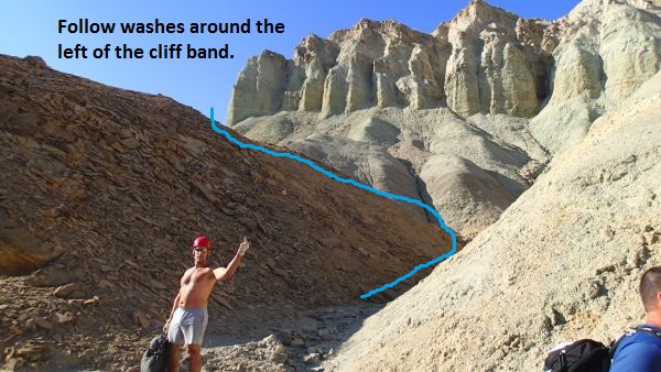
Follow the washes around the left side of the white conglomerate
cliff band.
After turning up the
leftmost fork
(wScorpionRP07) it will
veer right and begin
traveling southwest
again for about 200 feet
to a short easy scramble
up (wScorpionRP08).
After you get up the
scramble you should be
able to see an obvious
saddle about 350 feet
ahead to the southwest.
Note the water runnel
traveling down from the
saddle to the wash you
are in. Walk the
wash over to the runnel
then scramble your way
up the water runnel to
get up onto the saddle
(wScorpionRP09).
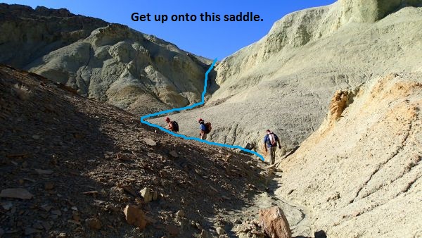
Follow the wash and the water runnel up onto this saddle.
From the saddle follow
down the water course on
the other side running
down to the west.
After about 300 feet you
will drop into a VERY
wide wash
(wScorpionRP10) which is
the Scorpion Canyon
drainage running down to
the northwest.
At this point the wash
is very wide and flat
providing easy walking
for long way.
About 0.8 miles down the
wash is another large
wash (jVinegaroon)
joining in from the
right (north).
Note:
To continue up to
Vinegaroon Canyon turn right and
travel north up this
wide side wash. If
you were going to
Scorpion Canyon you
would stay in the main
wash and travel down to
the west to continue on
the Scorpion Canyon
route.
When you get to the wide
side wash (jVinegaroon),
turn right and walk up
the wash to the north.
A few hundred feet up
the side wash and you
will be able to see a
saddle with yellowish
colored dirt mounds
leading up to it.
The saddle is about 0.25
miles up the side wash
from the Scorpion Canyon
drainage. As a
visual aid the saddle
has a dark brown topped
hill on its right right
(east) and a whitish
yellow hill on its left
(west). Route find
your way up the
yellowish mounds and
onto the saddle
(wVingroonRP01).
From the saddle turn
left and walk up the
ridge to the west about
700 feet up to a peak
along the ridge
(wVingroonRP02).
The peak has a large
cairn on it that is
likely left over from an
old mining claim.
Continue down the other
side of the peak
following the ridge
west. Follow
the ridge west about 0.2
miles to the top of a
slope (wVingroonRP03)
leading down to a large
wide open area of pink
and white dirt.
Drop down the slope to
the wide pink and white
open area.
Continue west in the
pink area for about 700
feet to where a wash
begins (wVingroonRP04)
to drop down to the left
(south).
When you get to where
the side starts dropping
down to the south
(wVingroonRP04), do not
follow down that wash.
Instead continue
straight by walking up
the pink and white dirt
slope to the west.
About 500 feet west up
the pink and white slope
is a saddle (jGowerTop).
The drainage dropping
down to the northwest
from here drops down
into upper portions of
Gower Gulch. To
continue to Vinegaroon
Canyon continue up to
the west roughly
following a ridge.
About 400 feet up along
the slope to the west
you will be able to see
down to another saddle
about 400 feet to the
northwest which is in
another section of pink
and white dirt.
Make your way over to
that pink - white
saddle. The
terrain is easy to
travel on but a little
convoluted so you will
need to route find your
way over to the pink -
white saddle. The
saddle is what is marked
as the top of Vinegaroon
Canyon (yVinegaroonTp).
Note:
The drainage running
down to the east will
lead down into upper
portions of Gower Gulch.
Vinegaroon Canyon runs
down to the west from
tis saddle. If you
want good views over
toward Furnace Creek,
walk up the slope to the
north a hundred feet or
so until you have the
view you like. If
you have the time it is
worth the short walk up
the slope for a look
around.
The Canyoneering / Technical Section:
From the saddle at
the top of Vinegaroon
Canyon (yVinegaroonTp)
start down the drainage
to the west. About
300 feet down canyon is
a downclimb of about 12
feet (wVingroonRP05).
About 200 feet down
canyon is the start
(wVingroonRP06) of a
section of canyon that
involves rock hopping
and easy scrambles.
About 500 feet down
canyon is an easy
downclimb of about 10
feet which is about 100
feet before reaching a
confluence. The
confluence after the
downclimb
(wVingroonRP07) is where
another fork joins in
from the RDC side.
Shortly after the
confluence is a drop of
about 15 feet that can
be bypassed by
scrambling down a slope
on the RDC side.
Just after is a
downclimb in a narrow
chute of about 10 feet
that is very awkward.
A short distance down
canyon is the top of a
section that begins to
drop more steeply over a
series of drops to
downclimb. This
section has a lot of
loose crumbly rock
making things a little
tedious. There are
3 drops of 10, 15 then 8
feet to downclimb before
reaching the top of rap
1.
Rap (dVingroonR1) is
anchored from a cairn
anchor and drops about
85 feet down a vertical
wall with most of the
rappel being free
hanging.
Note:
On the first descent it
took considerable effort
to farm rocks that were
large enough and solid
enough to use as the
anchor here. It is
unlikely for these rocks
to get washed out but if
they do it may take
considerable effort to
farm rocks to rebuild
the anchor for rap 1.
About 300 feet down
canyon is the top of
(wVingroonRP08) a narrow
section that is about
150 feet long with a
series of easy
downclimbs in it ranging
from 5 to 10 feet each.
A short distance after
the narrow slot is a
confluence where another
fork joins in from RDC.
A look back from here
gives a perspective on
how many forks could be
in this convoluted
terrain. Continue
down canyon in a wide
easy walking wash.
About 800 feet down
canyon and part way into
another narrow corridor
is a huge boulder
(wVingroonRP09) blocking
most of the canyon.
Walk around the RDC side
of it for the easiest
passage.
About 500 feet down
canyon is a steep slope
of about 20 feet to
scramble down.
After the scramble is
easy wash walking for
about 1000 feet to a
long rock slope
(wVingroonRP10) to walk
down followed by more
wash walking.
Shortly after the rock
slope is an easy
scramble down of about 8
feet.
Continue down canyon
with easy wash walking
for about 0.4 miles to
the top of rap 2.
Rap 2 (dVingroonR2) is
anchored from a knot
chalk about 15 feet back
from the drop and then
drops about 25 feet down
a vertical wall. About
40 feet of rope
travel will be needed.
There is also a lot of
rock material around
where a cairn anchor
could easily be built.
After rap 2 is easy wash
walking for a little
over 400 feet to the
start of a series of
easy scrambles
(wVingroonRP11).
The scrambles are where
the canyon makes a sharp
sweeping right then left
jog and starts down into
a deep feeling corridor
section. From here
to the end of the canyon
you will be in a more
narrow slot than above
and is a deep corridor
like feel all the way
through.
About 400 feet farther
down the corridor
section is another
series of 3 or 4 easy
scrambles.
About 700 feet farther
down the corridor is a
slope (wVingroonRP12)
that is an easy walk
down with a total drop
of about 25 feet.
About 200 feet down
canyon is another slope
to scramble down of
about 15 feet.
About 350 feet down
canyon is another slope
to scramble / downclimb
with a total drop of
about 20 feet.
About 200 feet down
canyon is a downclimb
(wVingroonRP13) of about
12 feet. The drops
prior to here have all
been more like scrambles
and you may have need
your hands in a few
places. This drops
is about 12 feet and you
will need hands and feet
to get down the vertical
wall.
About 400 feet of wash
walking leads to the top
of rap 3.
Rap 3 (dVingroonR3) is
anchored from a cairn
anchor about 10 feet
back and drops about
20 feet down a vertical
wall.
Rap 4 (dVingroonR4) is
about 175 feet down
canyon of rap 3 and is
anchored from a cairn
anchor dropping about 25
feet down a vertical
wall.
About 150 feet down
canyon is a downclimb
(wVingroonRP14) of about
25 feet that is broken
up into 3 drops of 6 to
8 feet each.
After the downclimb is
wash walking for a
little over 300 feet to
the top of two
downclimbs. The
first is about 6 feet
and pretty easy while
the second is about 9
feet and is a spicy
downclimb that most
people will want a
partner assist for.
Right at the bottom of
these downclimbs is the
top of rap 5.
Rap 5 (dVingroonR5) is
anchored from a cairn
anchor about 15 feet
back and drops about 25
feet down an almost
vertical wall.
About 40 feet of rope
travel will be needed.
Note:
Before sending the last
person down the
downclimbs to rap 5 have
someone go down and
check to see if the
anchor is still there.
It is unlikely it would
wash out but if it did
there is very little in
the way of anchor
options. Rocks
would need to be farmed
from above the
downclimbs to create
another anchor.
After rap 5 walk about
100 feet to where the
slot ends abruptly (yVinegaroonBt).
The Exit:
From the
end of the slot (yVinegaroonBt)
walk southwest toward
the road following along
the LDC side near a
steep gravel bank.
About 750 feet after
leaving the slot the
bank is low enough
(wVingroonRP15) to allow
an easy scramble up to
the top.
Scramble to the top of
the bank then walk
southish about 0.35
miles away to the exit
vehicles (tDesolationCyn),
which should be visible
shortly after getting to
the top of the gravel
bank.
Downloadable GPX files
available at
BG-Gear Store
(easier than manual entry and a great way to support
Bluugnome).
Waypoint naming convention and map symbol information can be found on the Glossary page.
Elevations are approximate.
BEFORE
manually entering coordinates set your system to WGS84 datum and Lat/Lon hddd.ddddd° coordinate format.
Inconsistent datum's and coordinate formats will result in location errors.
Click to show / expand the list of waypoints below........
| Vinegaroon (1) - Drive for exit vehicle parking and trailhead |
- extDesoltnCyn
Lat/Lon (WGS84): N 36.39660
W -116.84746
Elev: -205 Feet
Exit for the road to Desolation Canyon Trailhead.
- tDesolationCyn
Lat/Lon (WGS84): N 36.39565
W -116.83858
Elev: -50 Feet
Parking area at the end of the Desolation Canyon road. Also parking for the exit vehicle for the Scorpion Canyon and Vinegaroon Canyon Routes.
- ext-20Mule-In
Lat/Lon (WGS84): N 36.40941
W -116.79466
Elev: 840 Feet
Entrance to the 20 Mule Team Rd.
- pkScorpion
Lat/Lon (WGS84): N 36.39146
W -116.77847
Elev: 1,205 Feet
Parking spot to side of road in 20 Mule Team Road. 1 - 2 vehicles. This is the spot to park for the start of Scorpion Canyon or Vinegaroon Canyon.
|
| Vinegaroon (2) - Approach |
- pkScorpion
Lat/Lon (WGS84): N 36.39146
W -116.77847
Elev: 1,205 Feet
Parking spot to side of road in 20 Mule Team Road. 1 - 2 vehicles. This is the spot to park for the start of Scorpion Canyon or Vinegaroon Canyon.
- wScorpionRP01
Lat/Lon (WGS84): N 36.39231
W -116.77876
Elev: 1,195 Feet
To go up to Scorpion Canyon leave the Twenty Mule Team road here and start up the wash going southwest.
- wScorpionRP02
Lat/Lon (WGS84): N 36.38916
W -116.78129
Elev: NaN Feet
Small doorway shapped hole on the hillside. There is a tunnel here going through the hill to the otherside with a T part way in to a deadend tunnel part way into the hill.
- wScorpionRP03
Lat/Lon (WGS84): N 36.38779
W -116.78265
Elev: 1,360 Feet
The wash begins to get a little more narrow here.
- wScorpionRP04
Lat/Lon (WGS84): N 36.38702
W -116.78346
Elev: NaN Feet
Wash does a left - right jog here shortly before reaching a more wide open section of the wash.
- wScorpionRP05
Lat/Lon (WGS84): N 36.38700
W -116.78518
Elev: 1,450 Feet
Confluence of 3 forks. Follow the left most fork running up to the southwest.
- wScorpionRP06
Lat/Lon (WGS84): N 36.38624
W -116.78669
Elev: 1,660 Feet
A narrow spot to scramble up about 15 feet that is a little difficult since it is steep and has a lot of loose sand and gravel.
- wScorpionRP07
Lat/Lon (WGS84): N 36.38598
W -116.78724
Elev: NaN Feet
Top of a moderately steep section of scrambling and where the wash widens out again with easy wash walking. There is a confluence here of a few forks. Travel up the left most fork going southeast then shortly after turning right to travel southwest again.
- wScorpionRP08
Lat/Lon (WGS84): N 36.38552
W -116.78724
Elev: NaN Feet
Short easy scramble up in the wash. From here you can see an obvious saddle to the southwest about 350 feet away. Note the water runnel traveling up to the saddle. Continue up the wash then up the runnel to get up onto the saddle.
- wScorpionRP09
Lat/Lon (WGS84): N 36.38500
W -116.78812
Elev: 1,845 Feet
On top of a saddle after scrambling up a water runnel out of the wash. To drop into the Scorpion Drainage follow the water course running down the west side of the saddle for about 300 feet.
- wScorpionRP10
Lat/Lon (WGS84): N 36.38475
W -116.78913
Elev: 1,785 Feet
Route drops into the main water course for Scorpion Canyon.
- jVinegaroon
Lat/Lon (WGS84): N 36.38937
W -116.80203
Elev: 1,565 Feet
Large wash joining in from the right (north). Continue west down the wash to continue to Scorpion. Or Travel north up the side wash to follow the route to Vinegaroon Canyon.
- wVingroonRP01
Lat/Lon (WGS84): N 36.39232
W -116.79987
Elev: 1,745 Feet
A saddle used to gain access to the ridge.
- wVingroonRP02
Lat/Lon (WGS84): N 36.39278
W -116.80227
Elev: 1,870 Feet
Peak along the ridge with a large carin on it likely left over from a mining claim.
- wVingroonRP03
Lat/Lon (WGS84): N 36.39450
W -116.80471
Elev: 1,770 Feet
Top of a slope along the ridge leading down to the west to a large wide open pink and white dirt area.
- wVingroonRP04
Lat/Lon (WGS84): N 36.39533
W -116.80738
Elev: 1,651 Feet
Another wash starts dropping down to the south here leaving the white and pink dirt area. Do not follow down this wash. Instead continue west walking up the white and pink dirt slope to a saddle about 500 feet away.
- jGowerTop
Lat/Lon (WGS84): N 36.39616
W -116.80874
Elev: 1,665 Feet
Saddle on the approach to Vinegaroon Canyon. Dropping down the drainage to the north would drop into upper portions of Gower Gulch. To continue to Vinegaroon continue west roughly following a ridge.
- yVinegaroonTp
Lat/Lon (WGS84): N 36.39717
W -116.81102
Elev: 1,625 Feet
Pink / white saddle. This is the top of Vingaroon Canyon running down to the west. The drainage running down to the east will lead down into upper portions of Gower Gulch. Of note you can get a good view down to Furnace Creek by walking a hundred feet or so up the slope toward the peak to the north.
|
| Vinegaroon (3) - The Canyon and Exit |
- yVinegaroonTp
Lat/Lon (WGS84): N 36.39717
W -116.81102
Elev: 1,625 Feet
Pink / white saddle. This is the top of Vingaroon Canyon running down to the west. The drainage running down to the east will lead down into upper portions of Gower Gulch. Of note you can get a good view down to Furnace Creek by walking a hundred feet or so up the slope toward the peak to the north.
- wVingroonRP05
Lat/Lon (WGS84): N 36.39757
W -116.81167
Elev: NaN Feet
Downclimb of about 12 feet.
- wVingroonRP06
Lat/Lon (WGS84): N 36.39787
W -116.81243
Elev: NaN Feet
Start of a section where travel down canyon has a lot of rock hoping and easy scrambles.
- wVingroonRP07
Lat/Lon (WGS84): N 36.39933
W -116.81310
Elev: NaN Feet
Confluence where another fork joins in from the RDC side. This is about 100 feet down canyon of an easy downclimb of about 10 feet. About 50 feet downcanyon of this confluence is a drop of about 15 feet that is bypassed down a slope on the LDC side followed by a downclimb of about 10 feet in a narrow chute that bells ouot at the bottom and is very awkward.
- dVingroonR1
Lat/Lon (WGS84): N 36.39961
W -116.81342
Elev: 1,360 Feet
Rap 1 - Vinegaroon Canyon. Anchored from a cairn anchor and drops about 85 feet down a vertical wall with most of the rap as free hanging. Significant effort may be needed to farm anchor material if floods wash this one out.
- wVingroonRP08
Lat/Lon (WGS84): N 36.40014
W -116.81416
Elev: NaN Feet
Top of a narrow section with a series of easy downclimbs ranging from 5 to 10 feet. The narrow section is about 150 feet long before it opens up to wide wash.
- wVingroonRP09
Lat/Lon (WGS84): N 36.40196
W -116.81596
Elev: NaN Feet
Huge boulder blocking most of a narrow corridor. Walk around it on the RDC side.
- wVingroonRP10
Lat/Lon (WGS84): N 36.40330
W -116.82003
Elev: NaN Feet
Long rock slope to walk down. Shortly down canyon is a scramble down of about 8 feet.
- dVingroonR2
Lat/Lon (WGS84): N 36.40191
W -116.82592
Elev: 670 Feet
Rap 2 - Vinegaroon Canyon. Anchored from a knot chalk about 15 feet back on the LDC side and drops about 25 feet down a vertical wall. About 40 feet of rope travel will be needed. There are lots of rocks to build a cairn anchor if desired.
- wVingroonRP11
Lat/Lon (WGS84): N 36.40192
W -116.82738
Elev: NaN Feet
Canyon makes a sharp sweep right then left and starts a series of scrambles as you drop down into a deeper corridor like area. About 400 feet down canyon is another series of 3 or 4 easy scrambles.
- wVingroonRP12
Lat/Lon (WGS84): N 36.40210
W -116.83004
Elev: NaN Feet
Top of a slope in the corridor to walk down that has a total drop of about 25 feet. Down canyon of here are a couple more slopes to scramble down before reaching an actual downclimb about 700 feet down canyon.
- wVingroonRP13
Lat/Lon (WGS84): N 36.40237
W -116.83194
Elev: NaN Feet
Downclimb of about 12 feet. The drops prior to here have all been more like scrambles and you may have need your hands in a few places. This drops is about 12 feet and you will need hands and feet to get down the vertical wall.
- dVingroonR3
Lat/Lon (WGS84): N 36.40233
W -116.83285
Elev: NaN Feet
Rap 3 - Vinegaroon Canyon. Anchored from a cairn anchor about 10 feetback and drops about 20 feet down a vertical wall.
- dVingroonR4
Lat/Lon (WGS84): N 36.40189
W -116.83273
Elev: NaN Feet
Rap 4 - Vinegaroon Canyon. Anchored from a cairn anchor and drops about 25 feet down a vertical wall.
- wVingroonRP14
Lat/Lon (WGS84): N 36.40151
W -116.83252
Elev: 200 Feet
Downclimb of about 25 feet broken up over three drops of 6 to 8 feet each.
- dVingroonR5
Lat/Lon (WGS84): N 36.40116
W -116.83315
Elev: NaN Feet
Rap 5 -Vinegaroon Canyon. Anchored from a cairn anchor about 15 feet back and drops about 25 feet down an almost vertical wall. About 40 feet of rope travel will be needed. Try not to send everyone down the downclimbs to rap 5 before sending someone down to see if the anchor material is still there.
- yVinegaroonBt
Lat/Lon (WGS84): N 36.40111
W -116.83345
Elev: 115 Feet
End of Vinegaroon Canyon where the slot ends abruptly.
- wVingroonRP15
Lat/Lon (WGS84): N 36.40007
W -116.83583
Elev: 0 Feet
The gravel bank is low enough here to allow you to scramble up to the top of it to walk more south toward the car park at the Desolation Wilderness parking area.
- tDesolationCyn
Lat/Lon (WGS84): N 36.39565
W -116.83858
Elev: -50 Feet
Parking area at the end of the Desolation Canyon road. Also parking for the exit vehicle for the Scorpion Canyon and Vinegaroon Canyon Routes.
|