Canyoneering Route Description
Sidewinder Canyon - 3A III
Death Valley National Park,
California.
02-21-11, 17 people, 1 Day (Travel time in route 9 hours) - Lots of
people and a longer approach than described here.

Time Required - 7 to 10 hours
Distance - 6.0 miles Total, 1.0 miles Technical
Rappels - 9 Rappels, Longest Rappel 140 feet.
- Anchor for longest rap set back about 25 feet so 165 feet of
rope will be needed.
Elevation Range - -210 feet below sea level
thru 2860 Feet
Shuttle Required -No Vehicle - Passenger
Permit Required - No
Rappelling and anchor gear, Ropes and or pull cords for rappels up
to 165 feet and 150 feet of 1 inch webbing for sling placement.
ATTENTION!!
Death Valley is considering a new permit system in response to the impact of the growing popularity of Canyoneering.
Lets continue to show the park just how respectful we can be to our environment.
Specific issues the park is concerned about:
1. Anchors: Bolting is Illegal in Death Valley National Park! Do Not Add Bolts. Natural anchor options are abundant.
Recent illegal bolts have popped up in Helios and Rainbow Canyons.
2. Poop: Dig a cathole at least 6 inches deep and 200 yards from any water source or campsite. Pack out all toilet paper.
3. Collecting fire wood is illegal, just don't do it!
Other basics:
Avoid walking in water when possible (Willow Canyon, etc).
Hike on durable surfaces and previously worn paths (avoid trampling vegetation or fragile soil crusts).
Pack out all trash including organic material (including seed shells, apple cores, orange peels, etc).
More info can be found here: http://www.nps.gov/deva/planyourvisit/backcamp.htm
Lets keep this wonderful resource pristine so that we may continue to enjoy the canyons with limited regulations!
The technical section fun but the lower half of Sidewinder in the
conglomerate layer makes this route unique.
The long narrow section carved into the conglomerate layer near the
end of the canyon goes on for almost 0.75 miles and is very scenic.
This section is worth the time to enjoy. There are also some
side slots in this section that are well worth the time to hike /
scramble up into. This area is below the last rappel and would
make a great day hike to hike in from the bottom to check this area
out.
To get to the Trailhead
From the junction of highways 178 (Bad Water Road) and 190,
drive 16.6 miles south on highway 178 to Bad Water. Continue
south on highway 178 approximately 14.6 miles to a turn off (extWillowPkBt)
on the left (east). Turn left (east) then drive 0.2 miles to
where the road ends at a tee (pkWillowBt). When you get to
the tee, turn right (south) and drive about 350 feet to park at
the southern end of a hard dirt parking area (pkSideWndBt).
To leave the Exit Vehicle / Escape Pod
No exit vehicle is needed. This is done as a loop route.
GPS coordinate information listed at the bottom. For information about waypoint naming and map symbols, refer to the
Glossary page.

Click the links for maps of the route.
Map of the entire route.
Map of the technical section.
The Approach:
From the parking spot (pkSideWndBt) look south. The outlet of
Sidewinder Canyon is about 1500 feet south but hidden since the wide
gravel wash of Sidewinder wraps around the small hills you see to
the south of the parking spot. The small hills between the
parking spot and the outlet of Sidewinder are what you will climb up
to start the approach route. In these smaller hills note the
small drainage in these hills that is visibly the farthest right as
viewed from the parking spot. You will be scrambling up the
hill just right of that draiange.
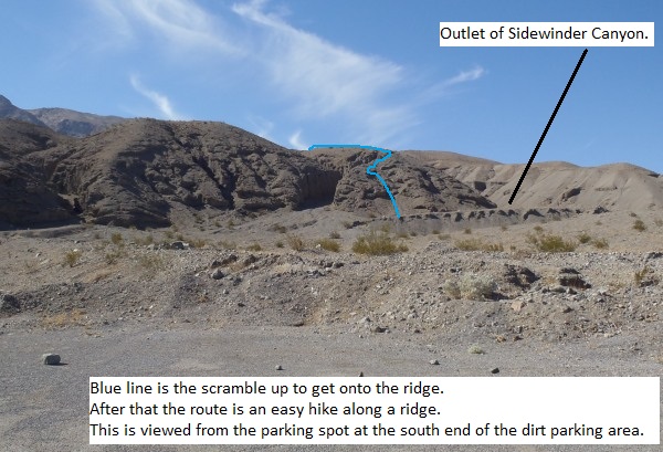
Hike across the desert to the south toward the outlet of Sidewinder.
Your goal so to scramble up the smaller hills just before reaching
Sidewinder to get up onto the ridge running along the north side of
side of Sidewinder. The picture below shows where you will
scramble up since this is difficult to explain in writing.
This is what will show as the caption. It can be as long or short as you like. The text will wrap and the border will expand down to
accommodate.
The base of the climb up onto the ridge (wSideWnd-Rp-01) is about
1100 feet south of the parking spot. Scramble / claw your way
up the loose dirt to get up onto the ridge. I say clay because
the dirt and rock is very steep and loose and you will need all four
limbs working to get up the first 60 or 80 feet. The route in
the picture where the blue line is seems to be the best start up.
After you get up the first 60 or 80 feet the route along the ridge
is an easy walk for long way. Once at the top of the slope
follow up the ridge as it winds a little along some narrow sections
then heads south east and widens out. About 500 feet along the
ridge you will have views down into the lower portions of Sidewinder
(wSideWnd-Rp-02).
Note:
Along the ridge will be some sections of faint paths to follow.
Other sections will look as though it has never been touched by man
or animal. Over the next mile and a half just follow south
east up along the crest of the ridge. In some spots where
there are game trails cut in, there are paths on both sides of the
ridge and sometimes on the crest of the ridge as well. Follow
what ever route feels best for you to get your self south east up
along the ridge.
As you travel up the ridge you will get occasional views down into
the lower portions of Sidewinder Canyon on the right (south).
The large drainage to the left (north) about 0.5 miles away is the
lower portion of Willow Canyon.
About 0.3 miles farther the ridge widens out into a large almost
flat area (wSideWnd-Rp-03). When you get to the large, wide,
almost flat area on the ridge, continue south east up the slope
toward what looks like a small peak / hill about 500 feet away.
When you get to the top of the small peak / hill (wSideWnd-Rp-04)
you are greeted with a clear view the still easy to follow ridge
line to the south east. Continue along the ridge line to the
south east.
A little over a mile farther up the ridge will be a saddle
(wSideWnd-Rp-05). You will have went over a couple other
saddles on the way up the ridge. What makes this saddle stand
out is that it is about 500 feet before reaching an obvious abrupt
grade change where the route gets significantly steeper. There
will also be a side drainage dropping down from the left (north)
side of this saddle.
Note:
The side drainage here can be hiked / scrambled to or from Willow
Canyon from here.
From the saddle continue east and start up the ridge on a path.
About 250 feet from the saddle the path will veer a bit left and
move away from the side of Sidewinder. About 500 feet will be
a whitish colored rock out cropping (wSideWnd-Rp-06).
From the whitish rock out cropping continue up the slope to the
east. About 300 feet from the whitish out cropping cross over
the head of a ravine (wSideWnd-Rp-07). As you cross over the
head of the ravine you might notice a faint path if you look close.
After crossing over the head of the ravine, continue east while
going up and traversing along the steep slope. A little over
200 feet after crossing the ravine you will get up onto the crest of
a ridge (wSideWnd-Rp-08) that runs up to the south east. When
you get to the crest of the ridge you may find a path leading east
then north east toward Willow Canyon. Do not follow the path.
Instead turn right and start going up the steep ridge to the south
east.
Going up the ridge to the south east is a moderate grade with no
paths so you will need to route find your way up. About 1300
feet up the ridge is a false high point (wSideWnd-Rp-09). The
ridge at this false high point veers left and continues Up to the
east. From this point you start to get views down into
Sidewinder again as the ridge roughly parallels Sidewinder Canyon.
About 0.4 miles farther up the ridge will be the top of a smaller
ridge (wSideWnd-Rp-10) that leaves the main ridge and drops to the
south down into Sidewinder. Continue south east up the main
ridge.
A little over 400 feet farther up the ridge is where to start the
descent (wSideWnd-Rp-11) down into Sidewinder. Start dropping
down into Sidewinder Canyon but don't just go straight down the
slope. Instead traverse along the side of the slope up canyon.
The goal is to drop to the floor of the canyon about 1000 feet up
canyon. Doing this will drop you in just above rap 1.
Note:
There are no easily identifiable landmarks to use. A GPS will
be handy if you are a bad judge of what 400 feet is. There are
also no landmarks for the traverse down into the canyon.
About 350 feet on the traverse along the slope the route will
intersect with a low use game trail (wSideWnd-Rp-12). When you
find it, follow the game trail as it continues to traverse south
east down to the canyon floor.
About 650 feet along the game trail will drop you down to the canyon
floor (ySidewinderTp) about 50 feet up canyon of rap 1.
Up canyon of this point looked to be a mellow wash with boulder
debris so we did not go farther up to explore it. This drop in
point is a little over a mile down canyon from the actual top of the
drainage up on the mountain.
The Canyoneering / Technical Section:
From the drop in point (ySidewinderTp) walk a few feet down canyon
to an easy down climb of about 15 to 20 feet.
Rap 1 (dSideWnd-R1) is about 50 feet down canyon of the drop in, is anchored from
cairn anchor 15 feet back from the drop and drops about 60 feet down a
mostly vertical wall. Rap 1 drops down to a large shelf.
About 50 feet down canyon of rap 1 is a down climb. The down
climb is not difficult but does have a lot of loose rock and some
exposure.
For safety, one of the better down climbers in the group could provide a top belay then down climb last. Those at the bottom can provide assistance from the bottom if needed.
After the down climb continue down canyon in a short section of
scree before starting a longer section of wash walking.
About 450 feet down canyon are two drops just before reaching rap 2.
The first drop is by-passable on the LDC side down a ramp. The
second drop is bypassed RDC over to a rock debris pile to scramble
down. Shortly after these drops is the top of rap 2.
Rap 2 (dSideWnd-R1) is about 650 feet down canyon of rap 1, is anchored from
a pinch point between two large rocks laying in the water course
about 15 feet back from the drop and drops about 35 feet down a
mostly vertical wall.
Just down canyon of rap 2 are a couple drops with an easy bypass up
and over to a large scree pile on the LDC side.
After the scree pile bypass is will be a combination of easy wash
walking with a few short easy down climbs / scrambles mixed in for
about 0.35 miles down to rap 3.
Rap 3 (dSideWnd-R3) is about 0.35 miles down canyon of rap 2, is anchored from
rock embedded in the wash and and drops over two stages with a
horizontal section between the stages. The first stage is
about 65 feet and the second stage is about 35 feet. Rap 3
will use about 150 feet of rope travel from top to bottom.
Rap 4 (dSideWnd-R4) is a little over 100 feet down canyon of rap 3, anchored from
large rocks at the top of the drop drops over two stages of about 40
feet each with a horizontal section between using about 115 feet of
rope travel for the rappel.
A little over 200 feet down canyon of rap 4 are a few short easy
down climbs. One of these drops is a sloped chute of 10 to 12
feet to slide down. The slope is gentle allowing for a well
controlled slide.
Rap 5 (dSideWnd-R5) is about 600 feet down canyon of rap 4, is anchored from
large rocks in the wash about 15 feet back from the drop and drops about
30 feet.
A little over 200 feet down canyon is a series of small easy down
climbs through a section of gray rock.
Rap 6 (dSideWnd-R6) is about 350 feet down canyon of rap 5, is anchored from
rock debris about 15 feet back from the drop and drops about 50 feet down a
mostly vertical wall in gray rock.
Down canyon of rap 6 is more wash walking for about 250 feet to a
drop of about 15 feet.
Another 130 feet down canyon the rock turns from grayish to white
where there is a pour off of about 30 feet and is by-passable up and
over on the LDC side then down a white white rock ramp. to the top
of another drop of about 12 feet that is sloped and an easy slide
down. Just after these two drops the rock turns from white
back to gray and travel down canyon is wash walking.
About 260 feet farther down canyon is is a drop in the gray rock.
The drop is down a sloped section of rock of about 40 feet and an
easy stem style down climb. Rap 7 is shortly down canyon.
Rap 7 (dSideWnd-R7) is about 700 feet down canyon of rap 6, is anchored from
cairn anchor 25 feet back from the drop and drops about 140 feet
down a mostly vertical wall. Rap 7 will use a total of about
165 feet of rope travel back to the anchor. The area around
the top of rap 7 is wide open and offers great views over Sidewinder
Canyon and out to the salt flats in the distance.
Rap 8 (dSideWnd-R8) is about 100 feet down canyon of rap 7, is anchored from
cairn style anchor piled in the water course and drops about 95 feet down
over three shelves creating 4 short drops in a rough semi narrow
slot.
Just after rap 8 is an easy down climb of about 20 feet then into a
section of gray rock narrows.
Rap 9 (dSideWnd-R9) is about 200 feet down canyon of rap 8 and is in the
gray narrows section after a down climb. Rap 9 is, is anchored from
a pinch point between a choke stone and the canyon wall and drops about
30 feet down a sloped narrow slot.
Note:
Rap 9 looks intimidating with the slick rock but is a
pretty easy down climb. Depending on the skill level of the
group this drop could easily be down climbed to save time. If
down climbing, one of the better down climbers in the group could provide a top belay then down climb last. Those at the bottom can provide assistance from the bottom if needed.
Just below rap 9 is a stem style down climb of about 20 feet.
At the bottom of the down climb is a side drainage joining in from
RDC. Continue right down canyon. Down canyon of this
down climb there is nothing else you will need a harness for so you
can take the gear off and be comfortable. There will still be
a few down climbs but nothing needing a harness.
Down canyon of here are sections of narrows, wash walking, and
multiple easy short down climbs.
About 0.5 miles down canyon of rap 9 you will start (wSideWnd-Rp-13)
into a section of narrows carved into a conglomerate layer.
This conglomerate slot is extremely scenic and worth taking the time
to enjoy. I would also recommend this as a destination for a
bottom up hike. This conglomerate slot goes on for about 0.75
miles.
About 0.5 miles into the conglomerate slot is a side slot
(wSideWnd-Rp-14) carved into the conglomerate layer on the left
(south). If you have time a hike / scramble up this side slot
is well worth the time. You can go along way up into the slot.
There are also a couple arches carved out of the conglomerate that
are pretty interesting to check out. This would also be a
reason to hike up form the bottom.
About 0.3 miles farther the narrow conglomerate slot opens up
(wSideWnd-Rp-15) to a VERY wide wash with conglomerate walls.
There is also another side slot to go check out on the left (south)
here just after the narrows opens up. This side slot goes a
long way in as well and feels over all a little darker than the one
farther up canyon.
After the canyon opens up walk down the side wash about 0.8 miles to
where it opens up onto the alluvial fan (ySidewinderBt).
The Exit:
Once out on the alluvial fan (ySidewinderBt), turn right (north) and
walk 0.3 miles over to the parking spot where you began (pkSideWndBt).
Downloadable GPX files
available at
BG-Gear Store
(easier than manual entry and a great way to support
Bluugnome).
Waypoint naming convention and map symbol information can be found on the Glossary page.
Elevations are approximate.
BEFORE
manually entering coordinates set your system to WGS84 datum and Lat/Lon hddd.ddddd° coordinate format.
Inconsistent datum's and coordinate formats will result in location errors.
Click to show / expand the list of waypoints below........
| Sidewinder 1 - Drive to Trailhead |
- extBadWatr-190
Lat/Lon (WGS84): N 36.44835
W -116.85247
Elev: 10 Feet
Junction of highway 190 and Badwater Road (178).
- extDevilsGolf
Lat/Lon (WGS84): N 36.29845
W -116.81171
Elev: -200 Feet
Turn off for the Devil's Golf Course. Park here to leave an exit vehicle when doing Brimstone Canyon.
- extNatBridge
Lat/Lon (WGS84): N 36.27404
W -116.79292
Elev: -241 Feet
Exit for the road to the Natural Bridge trailhead.
- sBadWater282
Lat/Lon (WGS84): N 36.23001
W -116.76791
Elev: -282 Feet
Sign at Bad Water Stating 282 feet below sea level
- extWillowPkBt
Lat/Lon (WGS84): N 36.06770
W -116.74806
Elev: -263 Feet
Exit to the parking area for the bottom of Willow Canyon.
- pkSideWndBt
Lat/Lon (WGS84): N 36.06467
W -116.74486
Elev: -210 Feet
Park here to start and finish the Sidewinder Canyon route. This is at the southern end of a dirt strip parking area.
|
| Sidewinder 2 - Approach |
- pkSideWndBt
Lat/Lon (WGS84): N 36.06467
W -116.74486
Elev: -210 Feet
Park here to start and finish the Sidewinder Canyon route. This is at the southern end of a dirt strip parking area.
- wSideWnd-Rp-01
Lat/Lon (WGS84): N 36.06180
W -116.74543
Elev: -100 Feet
Start of the scramble up onto the ridge for the approach to Sidewinder. The first 60 or 80 feet up this slope is very loose and steep and will be frustraiting. After tht the route is an easy hike along the ridge.
- wSideWnd-Rp-02
Lat/Lon (WGS84): N 36.06019
W -116.74516
Elev: NaN Feet
Here along the ridge you start to get views down into the bottom of Sidewinder which the ridge is now paralleling.
- wSideWnd-Rp-03
Lat/Lon (WGS84): N 36.05753
W -116.74249
Elev: NaN Feet
Large, wide, almost flat area along the ridge. Continue south east up toward what looks like a small peak / hill about 500 feet away.
- wSideWnd-Rp-04
Lat/Lon (WGS84): N 36.05687
W -116.74029
Elev: 410 Feet
Top of what looked like the small peak / hill. From here is a clear view of the still easy to follow ridge line running south east.
- wSideWnd-Rp-05
Lat/Lon (WGS84): N 36.04854
W -116.72583
Elev: 945 Feet
Saddle about 500 feet before an obvious abrupt grade change as you get closer to the mountain. Also the side drainage to the left (north) can be hiked / scrambed to and from Willow Canyon.
- wSideWnd-Rp-06
Lat/Lon (WGS84): N 36.04836
W -116.72423
Elev: NaN Feet
Whitish colored out cropping of rocks.
- wSideWnd-Rp-07
Lat/Lon (WGS84): N 36.04817
W -116.72331
Elev: 1,230 Feet
Crossing over the head of a ravine.
- wSideWnd-Rp-08
Lat/Lon (WGS84): N 36.04838
W -116.72261
Elev: 1,320 Feet
Up on the crest of a ridge running up to the south east. If you have found a path here Do not follow it east and north east toward Willow. Instead turn right and route find your way up the ridge to the south east.
- wSideWnd-Rp-09
Lat/Lon (WGS84): N 36.04549
W -116.72038
Elev: 1,920 Feet
False highpoint along the ridge.
- wSideWnd-Rp-10
Lat/Lon (WGS84): N 36.04379
W -116.71483
Elev: 2,670 Feet
This is where a smaller ridge leaves the main ridge you are on and drops to the right (south) down into Side Winder. Continue south east up the main ridge.
- wSideWnd-Rp-11
Lat/Lon (WGS84): N 36.04327
W -116.71368
Elev: 2,820 Feet
Start the descent down from the ridge by traversing up canyon as you descend.
- wSideWnd-Rp-12
Lat/Lon (WGS84): N 36.04262
W -116.71285
Elev: NaN Feet
Route intersects with a low use game trail that leads south east down to the canyon floor.
- ySidewinderTp
Lat/Lon (WGS84): N 36.04108
W -116.71208
Elev: 2,810 Feet
Top entry for Sidewinder Canyon. THis is where a game trail dropped into the canyon about 50 feet upcanyon of rap 1.
|
| Sidewinder 3 - The Canyon and Exit |
- ySidewinderTp
Lat/Lon (WGS84): N 36.04108
W -116.71208
Elev: 2,810 Feet
Top entry for Sidewinder Canyon. THis is where a game trail dropped into the canyon about 50 feet upcanyon of rap 1.
- dSideWnd-R1
Lat/Lon (WGS84): N 36.04117
W -116.71219
Elev: NaN Feet
Rap 1 - Sidewinder Canyon. Anchored from a cairn anchor about 15 feet back and drops about 60 feet.
- dSideWnd-R2
Lat/Lon (WGS84): N 36.04177
W -116.71407
Elev: NaN Feet
Rap 2 - Sidewinder Canyon. Anchored from a pinch point between large rocks in the wash and drops about 35 feet.
- dSideWnd-R3
Lat/Lon (WGS84): N 36.04301
W -116.71837
Elev: NaN Feet
Rap 3 - Sidewinder Canyon. Anchored from large rock embedded int eh wash and uses about 150 feet of rope travel as it drops over two stages of 65 and 35 feet with a horizontal section between.
- dSideWnd-R4
Lat/Lon (WGS84): N 36.04344
W -116.71862
Elev: 1,960 Feet
Rap 4 - Sidewinder Canyon. Anchored from large rocks laying in the wash and drops over two stages of about 40 feet each using 115 feet of rope travel.
- dSideWnd-R5
Lat/Lon (WGS84): N 36.04397
W -116.72020
Elev: 1,753 Feet
Rap 5 - Sidewinder Canyon. Anchored from large rocks in the wash about 15 feet back from the drop and drops about 30 feet.
- dSideWnd-R6
Lat/Lon (WGS84): N 36.04445
W -116.72127
Elev: 1,660 Feet
Rap 6 - Sidewinder Canyon. Anchored from rock debris about 15 feet back from the drop and drops about 50 feet in gray rock.
- dSideWnd-R7
Lat/Lon (WGS84): N 36.04495
W -116.72341
Elev: NaN Feet
Rap 7 - Sidewinder Canyon. Anchored from a cairn anchor about 25 feet back and drops about 140 feet down a mostly vertical wall and will use about 165 feet of rope travel back to the anchor. Great big wide open views from teh top of rap 7.
- dSideWnd-R8
Lat/Lon (WGS84): N 36.04499
W -116.72376
Elev: NaN Feet
Rap 8 - Sidewinder Canyon. Anchored from cairn anchor in the water course and drops about 95 feet over a series of 4 short drops in a rough semi narrow slot.
- dSideWnd-R9
Lat/Lon (WGS84): N 36.04508
W -116.72439
Elev: 1,206 Feet
Rap 9 - Sidewinder Canyon. Anchored from a pinch point between a choke stone and the canyon wall and drops about 30 feet in a narrow slot. Rap 9 can be down climbed by those comfortable with chimney style down climbs.
- wSideWnd-Rp-13
Lat/Lon (WGS84): N 36.04802
W -116.72965
Elev: 730 Feet
Starting into a narrows that is carved out of a conglomerate layer.
- wSideWnd-Rp-14
Lat/Lon (WGS84): N 36.05162
W -116.73482
Elev: NaN Feet
Side slot to hike up and check out in the conglomerate layer. Worth the side trip if you have time.
- wSideWnd-Rp-15
Lat/Lon (WGS84): N 36.05298
W -116.73864
Elev: 340 Feet
The narrow conglomerate section opens up to a very wide wash with conglomerate walls. Also there is another side slot carved into the left (south) side just down canyon of here.
- ySidewinderBt
Lat/Lon (WGS84): N 36.06135
W -116.74650
Elev: -100 Feet
Bottom exit of Sidewinder. This is where the canyon dumps out onto it's alluvial fan. The last part of technical difficulty is about 1.8 miles up canyon of here.
- pkSideWndBt
Lat/Lon (WGS84): N 36.06467
W -116.74486
Elev: -210 Feet
Park here to start and finish the Sidewinder Canyon route. This is at the southern end of a dirt strip parking area.
|