Canyoneering Route Description
Scorpion Canyon - 3A II
Death Valley National Park,
California.
11-16-12, 6 people, 1 Day (Travel time in route 5.4 hours)

Time Required - 3 to 6 hours
Distance - 4.6 miles Total, 1.9 miles Technical
Rappels - 7 Rappels, Longest Rappel 150 feet.
Elevation Range - 1845 - 50 Feet below sea level
Shuttle Required - Yes 10.9 Miles Vehicle - Passenger
Permit Required - No
Rappelling and anchor gear. Ropes and pull cords for rappels up
to 150 feet and 60 feet of 1 inch webbing for sling placement.
Rap 5 can use up to 20 feet of webbing if you need to replace it
which is why the amount of webbing recommended may sound high.
ATTENTION!!
Death Valley is considering a new permit system in response to the impact of the growing popularity of Canyoneering.
Lets continue to show the park just how respectful we can be to our environment.
Specific issues the park is concerned about:
1. Anchors: Bolting is Illegal in Death Valley National Park! Do Not Add Bolts. Natural anchor options are abundant.
Recent illegal bolts have popped up in Helios and Rainbow Canyons.
2. Poop: Dig a cathole at least 6 inches deep and 200 yards from any water source or campsite. Pack out all toilet paper.
3. Collecting fire wood is illegal, just don't do it!
Other basics:
Avoid walking in water when possible (Willow Canyon, etc).
Hike on durable surfaces and previously worn paths (avoid trampling vegetation or fragile soil crusts).
Pack out all trash including organic material (including seed shells, apple cores, orange peels, etc).
More info can be found here: http://www.nps.gov/deva/planyourvisit/backcamp.htm
Lets keep this wonderful resource pristine so that we may continue to enjoy the canyons with limited regulations!
Scorpion Canyon is a short easy route with good scenery on
the approach and in the canyon. Scorpion Canyon does require a car shuttle
but it is short and simple. If you are looking for a an easy fun day out,
Scorpion Canyon is a great choice.
For a similar canyon in the area but with much better
scenic views during the approach, check out Vinegaroon Canyon.
To get to the Trailhead
From the Junction of highway 190 and highway 178, drive south
east on highway 190 for 4.7 miles to the turn off for the Twenty
Mule Team road (ext-20Mule-In) on the right (south) side of the
highway. The Twenty Mule Team road is a dirt road that
runs for about 2.6 miles and comes back out to the highway a
little south of where you entered. Turn right (south) onto
the Twenty Mule Team road and drive 1.7 miles to a parking
turnout on the right (pkScorpion). This turnout is
just as you reach a sharp left hand bend in the road. Park
the entry vehicle here. Remember to go set an exit vehicle
as this route requires a shuttle.
To leave the Exit Vehicle / Escape Pod
From the Junction of highway 190 and highway 178 (Badwater
Road), drive south on highway 178 for 3.7 miles to a dirt road
(extDesoltnCyn) on the left (east). Turn left onto the
Desolation Canyon road and drive 0.5 miles east to the end of
the dirt road where there is a large parking area (tDesolationCyn).
Park the exit vehicle here.
GPS coordinate information listed at the bottom. For information about waypoint naming and map symbols, refer to the
Glossary page.

Click the links for maps of the route.
Map of the entire route.
Map of the approach.
Map of the technical section.
Map of the exit.
The Approach:
From the parking spot (pkScorpion)
walk about 350 feet
north on the Twenty Mule
Team road to a large
wash (wScorpionRP01)
leaving the road and
traveling southwest.
Turn left and walk
southwest up the large
wide wash. About
700 feet from the road
the wash is wide and may
seem to have forks
coming in. Just
keep following straight
up southwest of what
feels like the main
wash.
About 0.28 miles up the
wash you may notice a
doorway shaped hole
(wScorpionRP02) in the
hillside on the left
(southeast) side.
There are a couple short
tunnels here. As a
general rule it is best
to do as the park
says.... Stay Out - Stay
Alive.
Another 650 feet
southwest up the
drainage is where the
wash begins to get a
little more narrow
(wScorpionRP03).
About 400 feet farther
the wash makes a left -
right jog
(wScorpionRP04) shortly
before getting to a more
wide open section of the
wash.
About 350 to 400 feet
farther will be a spot
to scramble up about 15
feet. Just after
the scramble up will be
a confluence of 3 forks
(wScorpionRP05).
From the confluence
travel southwest up the
left most fork.
Travel from here gets
steeper but is mostly an
easy walk up with an
occasional spot where
you might want to use
your hands for balance.
About 500 feet farther
is a narrow spot where
you need to scramble
about 15 feet up a steep
section (wScorpionRP06)
that also has a lot of
loose sand and gravel on
it.
Continue light
scrambling up a
moderately steep section
for about 200 feet until
you get to a more wide
open area
(wScorpionRP07) and easy
wash walking again.
There is a confluence
here of a few forks.
Travel up the left most
fork going southeast
then shortly after
turning right to travel
southwest again.
Note:
From this confluence you
can see a white
conglomerate cliff band
ahead to the west.
What you will be trying
to do from here is
travel up to the left
(south) side of the
cliff band.
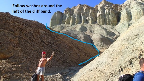 Follow the washes around the left side of the white conglomerate cliff band.
After turning up the
leftmost fork
(wScorpionRP07) it will
veer right and begin
traveling southwest
again for about 200 feet
to a short easy scramble
up (wScorpionRP08).
After you get up the
scramble you should be
able to see an obvious
saddle about 350 feet
ahead to the southwest.
Note the water runnel
traveling down from the
saddle to the wash you
are in. Walk the
wash over to the runnel
then scramble your way
up the water runnel to
get up onto the saddle
(wScorpionRP09).
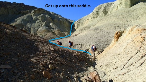 Follow the wash and the water runnel up onto this saddle.
From the saddle follow
down the water course on
the other side running
down to the west.
After about 300 feet you
will drop into a VERY
wide wash
(wScorpionRP10) which is
the Scorpion Canyon
drainage running down to
the northwest.
At this point the wash
is very wide and flat
providing easy walking
for long way.
About 0.8 miles down the
wash is another large
wash (jVinegaroon)
joining in from the
right (north).
Note:
Stay in the main wash
and travel down to the
west to continue on the
Scorpion Canyon route.
If you were going to
Vinegaroon Canyon you
would turn right and
travel north up this
wide side wash.
About 0.25 miles down
the wash the walls close
in a little with brown
conglomerate rock giving
a more narrow feel (yScorpionTp).
Since this is the first
place the wash begins to
feel like it might get
more narrow it makes a
good spot to label as
the head of the canyon.
The Canyoneering / Technical Section:
From where the
wash got a little more
narrow (yScorpionTp)
walk about 375 feet to
the top of a drop of
about 25 feet (wScorpionRP12).
The drop is easily
bypassed walking down
the slope on the LDC
side. About 200
feet down canyon is a
right - left jog in the
canyon just before it
opens up to more wide
easy wash walking.
Walk the open wash about
0.6 miles to the top of
rap 1.
Rap 1 (dScorpionR1)
drops down through a
doorway like hole into a
narrow section.
Rap 1 is anchored from a
large rock about 10 feet
back from the drop and
uses about 135 feet of
rope travel to drop over
two stages. The
first stage is about 25
feet with a long ledge
to the second stage
dropping about 30 feet.
Down canyon of rap 1 is
a section with multiple
easy downclimbs ranging
in height from 6 to 20
feet. The
downclimbs are scattered
over the next 500 feet
of canyon before
reaching a boulder
debris pile
(wScorpionRP13).
The boulder debris pile
(wScorpionRP13) has a
drop of about 20 feet
going under a couple of
the boulders. The
drop under the boulders
looks like a rappel but
can be downclimbed with
moderate difficulty.
There are plenty of hand
and foot holds but be
aware of loose rock that
can break away.
Just after the boulder
debris downclimb is an
easy scramble of about
10 feet then a wash walk
of about 100 feet to the
top of rap 2.
Rap 2 (dScorpionR2)
anchored from a cairn
anchor about 10 feet
back from the drop and
drops about 95 feet down
a mostly vertical wall
with some ledge like
features to step over
about mid way down.
Down canyon of rap 2 are
a few short easy
downclimbs spread out
over about 600 feet of
wash. about 600
feet down canyon of rap
2 is a split in the
watercourse
(wScorpionRP14).
To get to rap 3 follow
down the LDC (south)
split and scramble
through some pinkish
boulder debris.
Rap 3 is about 150 feet
after the split.
An anchor was also set
in the right split but I
gathered no information
on that rappel.
Both routes will rejoin
just down canyon of the
rappel.
Rap 3 (dScorpionR3) is
anchored from a cairn
anchor and drops about
150 feet down a mostly
vertical wall with a
short portion of free
hang near the end.
Be careful of placement
of the cairn anchor
since anything rolling
off the anchor will go
over the rappel.
After rap 3 walk a short
distance to a confluence
where the up canyon
split in the watercourse
rejoins then walk about
60 feet down canyon to
the top of rap 4.
Rap 4 (dScorpionR4) is
anchored from a large
rock on the LDC side and
drops about 25 feet down
a vertical wall.
Down canyon of rap 4 is
a scenic corridor like
section.
Down canyon from rap 4
is a long wash walking
section with great
scenery. The wash
walk is about 0.8 miles
long with a couple of
spots of short easy
scrambles to break up
the walk a little.
Just before reaching rap
5 is a downclimb of
about 12 feet in a
narrow chute.
Rap 5 (dScorpionR5) is
anchored from a very
large rock protrusion
about 15 feet back from
the drop and drops about
35 feet down a vertical
wall using a total of 50
feet of rope travel.
Rap 6 (dScorpionR6) is
about 180 feet down
canyon of rap 5.
Rap 6 is anchored from a
rock pile on the RDC
wall about 8 feet back
and drops about 60 feet
down a vertical wall.
After rap 6 walk down
canyon about 500 feet
down canyon to the top
of rap 7 where you can
see the alluvial fan
just down canyon where
things open up.
Rap 7 (dScorpionR7) is
anchored from a cairn
anchor and drops about
60 feet down a mostly
vertical wall.
After rap 7 walk about
80 feet out to where the
canyon ends (yScorpionBt)
and you are out on the
alluvial fan.
The Exit:
From the
end of Scorpion Canyon (yScorpionBt)
walk 0.43 miles
southwest on a bearing
of 242 degrees (true) to
get to the cars parked
at the Desolation Canyon
Trailhead (tDesolationCyn).
Note:
You can not see the cars
from the exit of the
canyon so use a compass
GPS or just be good with
direction to stay on
course. As you get
closer to the cars you
will start to notice you
are walking toward a
small blackish hill.
The trailhead is on the
west side of that hill.
Downloadable GPX files
available at
BG-Gear Store
(easier than manual entry and a great way to support
Bluugnome).
Waypoint naming convention and map symbol information can be found on the Glossary page.
Elevations are approximate.
BEFORE
manually entering coordinates set your system to WGS84 datum and Lat/Lon hddd.ddddd° coordinate format.
Inconsistent datum's and coordinate formats will result in location errors.
Click to show / expand the list of waypoints below........
| Scorpion (1) - Drive for exit vehicle parking and trailhead |
- extDesoltnCyn
Lat/Lon (WGS84): N 36.39660
W -116.84746
Elev: -205 Feet
Exit for the road to Desolation Canyon Trailhead.
- tDesolationCyn
Lat/Lon (WGS84): N 36.39565
W -116.83858
Elev: -50 Feet
Parking area at the end of the Desolation Canyon road. Also parking for the exit vehicle for the Scorpion Canyon and Vinegaroon Canyon Routes.
- ext-20Mule-In
Lat/Lon (WGS84): N 36.40941
W -116.79466
Elev: 840 Feet
Entrance to the 20 Mule Team Rd.
- pkScorpion
Lat/Lon (WGS84): N 36.39146
W -116.77847
Elev: 1,205 Feet
Parking spot to side of road in 20 Mule Team Road. 1 - 2 vehicles. This is the spot to park for the start of Scorpion Canyon or Vinegaroon Canyon.
|
| Scorpion (2) - Approach |
- pkScorpion
Lat/Lon (WGS84): N 36.39146
W -116.77847
Elev: 1,205 Feet
Parking spot to side of road in 20 Mule Team Road. 1 - 2 vehicles. This is the spot to park for the start of Scorpion Canyon or Vinegaroon Canyon.
- wScorpionRP01
Lat/Lon (WGS84): N 36.39231
W -116.77876
Elev: 1,195 Feet
To go up to Scorpion Canyon leave the Twenty Mule Team road here and start up the wash going southwest.
- wScorpionRP02
Lat/Lon (WGS84): N 36.38916
W -116.78129
Elev: NaN Feet
Small doorway shapped hole on the hillside. There is a tunnel here going through the hill to the otherside with a T part way in to a deadend tunnel part way into the hill.
- wScorpionRP03
Lat/Lon (WGS84): N 36.38779
W -116.78265
Elev: 1,360 Feet
The wash begins to get a little more narrow here.
- wScorpionRP04
Lat/Lon (WGS84): N 36.38702
W -116.78346
Elev: NaN Feet
Wash does a left - right jog here shortly before reaching a more wide open section of the wash.
- wScorpionRP05
Lat/Lon (WGS84): N 36.38700
W -116.78518
Elev: 1,450 Feet
Confluence of 3 forks. Follow the left most fork running up to the southwest.
- wScorpionRP06
Lat/Lon (WGS84): N 36.38624
W -116.78669
Elev: 1,660 Feet
A narrow spot to scramble up about 15 feet that is a little difficult since it is steep and has a lot of loose sand and gravel.
- wScorpionRP07
Lat/Lon (WGS84): N 36.38598
W -116.78724
Elev: NaN Feet
Top of a moderately steep section of scrambling and where the wash widens out again with easy wash walking. There is a confluence here of a few forks. Travel up the left most fork going southeast then shortly after turning right to travel southwest again.
- wScorpionRP08
Lat/Lon (WGS84): N 36.38552
W -116.78724
Elev: NaN Feet
Short easy scramble up in the wash. From here you can see an obvious saddle to the southwest about 350 feet away. Note the water runnel traveling up to the saddle. Continue up the wash then up the runnel to get up onto the saddle.
- wScorpionRP09
Lat/Lon (WGS84): N 36.38500
W -116.78812
Elev: 1,845 Feet
On top of a saddle after scrambling up a water runnel out of the wash. To drop into the Scorpion Drainage follow the water course running down the west side of the saddle for about 300 feet.
- wScorpionRP10
Lat/Lon (WGS84): N 36.38475
W -116.78913
Elev: 1,785 Feet
Route drops into the main water course for Scorpion Canyon.
- jVinegaroon
Lat/Lon (WGS84): N 36.38937
W -116.80203
Elev: 1,565 Feet
Large wash joining in from the right (north). Continue west down the wash to continue to Scorpion. Or Travel north up the side wash to follow the route to Vinegaroon Canyon.
- yScorpionTp
Lat/Lon (WGS84): N 36.39049
W -116.80677
Elev: 1,475 Feet
The wash gets a little more narrow and has brown conglomerate rock on the sides.
|
| Scorpion (3) - The Canyon and Exit |
- yScorpionTp
Lat/Lon (WGS84): N 36.39049
W -116.80677
Elev: 1,475 Feet
The wash gets a little more narrow and has brown conglomerate rock on the sides.
- wScorpionRP12
Lat/Lon (WGS84): N 36.39121
W -116.80760
Elev: NaN Feet
Drop of about 25 feet with a sloped hands free bypass to walk down on the LDC side. About 200 feet down canyon is a left - right jog just as the canyon opens to more wide open wash walking for over half mile.
- dScorpionR1
Lat/Lon (WGS84): N 36.39465
W -116.81551
Elev: 1,226 Feet
Rap 1 - Scorpion Canyon. Anchored from a large rock about 10 feet back from a door way like opening and uses about 135 feet of rope travel to drop over two stages. The next 50o feet of canyon has multiple easy downclimbs ranging from 6 to 20 feet before reaching a boulder debris pile.
- wScorpionRP13
Lat/Lon (WGS84): N 36.39574
W -116.81667
Elev: NaN Feet
Boulder debris pile has a drop of about 20 feet going under a couple of the boulders. The drop under the boulders looks like a rappel but can be downclimbed with moderate difficulty. There are plenty of hand and foot holds but be aware of loose rock that can break away.
- dScorpionR2
Lat/Lon (WGS84): N 36.39599
W -116.81704
Elev: NaN Feet
Rap 2 - Scorpion Canyon. Anchored from a cairn anchor about 10 feet back from the drop and drops about 95 feet down a mostly vertical wall with some ledge like features to step over about mid way down.
- wScorpionRP14
Lat/Lon (WGS84): N 36.39668
W -116.81884
Elev: NaN Feet
Split in the water course. Rap 3 is down the LDC (south) fork about 150 feet away through some boulder debris to scramble through. A rappel can also be set by dropping down the the RDC side of the split but I have no information on that rap. Both routes will rejoin just below the rappels.
- dScorpionR3
Lat/Lon (WGS84): N 36.39677
W -116.81939
Elev: NaN Feet
Rap 3 - Scorpion Canyon. Down the LDC side of a split in the water course just up canyon. Anchored from a cairn anchor and drops about 150 feet down a mostly vertical wall with a short portion of free hang near the end. Be careful of placement of the cairn anchor since anything rolling off the anchor will go over the rappel.
- dScorpionR4
Lat/Lon (WGS84): N 36.39708
W -116.81948
Elev: 720 Feet
Rap 4 - Scorpion Canyon. Anchored from a large rock on the LDC side and drops about 25 feet down a vertical wall.
- dScorpionR5
Lat/Lon (WGS84): N 36.39883
W -116.82980
Elev: 245 Feet
Rap 5 - Scorpion Canyon. Anchored from a very large rock protrusion about 15 feet back from the drop and drops about 35 feet down a vertical wall using a total of 50 feet of rope travel.
- dScorpionR6
Lat/Lon (WGS84): N 36.39856
W -116.83000
Elev: NaN Feet
Rap 6 - Scorpion Canyon. Anchored from a rock pile on the RDC wall about 8 feet back and drops about 60 feet down a vertical wall.
- dScorpionR7
Lat/Lon (WGS84): N 36.39865
W -116.83153
Elev: NaN Feet
Rap 7 - Scorpion Canyon. Anchored from a cairn anchor and drops about 60 feet down a mostly vertical wall.
- yScorpionBt
Lat/Lon (WGS84): N 36.39860
W -116.83178
Elev: 90 Feet
Bottom of Scorpion Canyon where it drops out to the alluvial fan.
- tDesolationCyn
Lat/Lon (WGS84): N 36.39565
W -116.83858
Elev: -50 Feet
Parking area at the end of the Desolation Canyon road. Also parking for the exit vehicle for the Scorpion Canyon and Vinegaroon Canyon Routes.
|