Canyoneering Route Description
Rainbow Canyon - 3A I
Death Valley National Park, California.
03-27-10, 4 people, 1 Day (Travel time in route 3.5 hours)

04-24-11, 6 people, 1 Day (Travel time in route 3.8 hours)
Time Required - 3 to 4 hours
Distance - 2.2 miles Total, 0.7 miles Technical
Rappels - 3 Rappels, Longest Rappel 150 feet.
Elevation Range - 4600 -
3860 Feet
Shuttle Required - Optional 0.3 miles Vehicle - Passenger
Permit Required - No
Rappelling and anchor gear, Ropes and or pull cords for rappels up
to 170 feet, 20 feet of 1" webbing for sling placement. Longest
rappel is 150 but the anchor is set back about 20 feet which is why
170 feet is listed here under gear.
ATTENTION!!
Death Valley is considering a new permit system in response to the impact of the growing popularity of Canyoneering.
Lets continue to show the park just how respectful we can be to our environment.
Specific issues the park is concerned about:
1. Anchors: Bolting is Illegal in Death Valley National Park! Do Not Add Bolts. Natural anchor options are abundant.
Recent illegal bolts have popped up in Helios and Rainbow Canyons.
2. Poop: Dig a cathole at least 6 inches deep and 200 yards from any water source or campsite. Pack out all toilet paper.
3. Collecting fire wood is illegal, just don't do it!
Other basics:
Avoid walking in water when possible (Willow Canyon, etc).
Hike on durable surfaces and previously worn paths (avoid trampling vegetation or fragile soil crusts).
Pack out all trash including organic material (including seed shells, apple cores, orange peels, etc).
More info can be found here: http://www.nps.gov/deva/planyourvisit/backcamp.htm
Lets keep this wonderful resource pristine so that we may continue to enjoy the canyons with limited regulations!
The traditional Rainbow Canyon route covers the portion of the
canyon in this route plus a long walk down the lower section of the
canyon. The lower section of the canyon (down canyon of the route
described here) is a long walk in a wash with large rocks making
travel difficult. The lower canyon has only one short rappel, so
there is no technical draw to that part of the canyon. This shorter
route gets you through the fun part then escapes the canyon to avoid
the not so fun part.
The section of raps 2 and 3 is where you get a view of why this is
called Rainbow Canyon. From the top of rap 2 you have a view
of the LDC wall down canyon with reddish brown stripes in the gray
canyon wall.
Rap 3 is down a colorful rainbow striped wall with gray, red, orange and white
stripes.
When I was there in 2010 and 2011 the bottom
of rap 2 had a large sink hole that was easy to scramble up and out
the down canyon side. In 2022 Brian Moore contacted me and
said things had changed. I was told the sinkhole/pothole is
now a keeper, maybe 25' deep with vertical walls for the bottom 15'
or so. The rappel ends on a ledge above it, from which you have a
choice of a very exposed traverse either left or right to bypass it
which many people will find uncomfortable.
A shuttle is optional for Rainbow Canyon. The distance between the
two parking spots is about 0.3 miles on the road. If you only
have one vehicle or don't mind an additional 0.3 mile walk you can
do this as a loop route. If you decided to walk between
parking spots please consider staying off the highway and walk in
the desert instead. The road here is narrow and curvy.
This section of the highway could easily lead to a driver not seeing
a pedestrian and accidentally hitting them. Consider this
before walking the road.
Rainbow is a short canyon and
can easily be combined with Darwin Falls for a day out.
To get to the Trailhead
From Panamint Springs (lPanamintSpngs) drive west on highway 190
about 9.9 miles and pull over to start the route (PkRainbow-Tp).
To leave the Exit Vehicle / Escape Pod
From Panamint Springs (lPanamintSpngs) drive west on highway 190
about 9.6 miles and pull over to drop the exit vehicle (PkRainbow-Mid).
There is a pull out here large enough for about 3 cars near a
guard rail on the east side of the road. This pull out is 0.3 miles before getting to
the parking spot to start the route.
Panamint Springs is a small town about 14 miles west of the
western boarder of Death Valley National Park on highway 190.
Yup Rainbow Canyon is outside the park.
GPS coordinate information listed at the bottom. For information about waypoint naming and map symbols, refer to the
Glossary page.

Click the links for maps of the route.
Map of the entire route.
The Approach:
From the parking spot (PkRainbow-Tp), walk north in the
desert about 50 feet along the east side
of the highway. About 300 feet after leaving the parking
spot you should notice a very obvious dirt road that is no longer
used (wRainbowRP-1). This old dirt road has rock spread out
all over it in an attempt to hide it and keep people from driving on
it.
A little over 500 feet farther the road crosses over a wash
(wRainbowRP-2).
About 300 feet after crossing the wash the road slowly turns right
(north east) and continues down toward the drainage for Rainbow
Canyon. The road here is very obvious and easy to follow.
Follow the road for another 0.7 miles to where it dumps into the
large drainage for Rainbow Canyon (wRainbowRP-3).
Turn right (south east) and walk about 500 feet down the wash to
what is marked as the head of Rainbow Canyon (yRainbowTp). In
this area you will find a drop of about 20 feet.
The Canyon / Technical Section:
At the head of the canyon (yRainbowTp) is a downclimb on the LDC
side of about 15 or 20 feet in a section of brown and black volcanic
rock, Continue down canyon about 80 feet to rap 1.
(dRainbowR1)
Rap 1 is anchored from a large rock RDC and drops about
95 feet down a mostly vertical wall. The wall starts off almost
black and has a reddish brown stripe along the bottom providing your
first taste of the rainbow. The next 0.2 miles of canyon is
mostly easy travel with one gradual drop to navigate down over
boulders.
(dRainbowR2-3) Rap 2 (170 feet rope travel) is
anchored from a large cairn anchor about 20 feet back and drops about 150 feet down a
mostly vertical wall. When I was there in 2010 and 2011 the bottom
of rap 2 had a large sink hole that was easy to scramble up and out
the down canyon side. In 2022 I was told the sinkhole/pothole
is now a keeper, maybe 25' deep with vertical walls for the bottom
15' or so. The rappel ends on a ledge above it, from which you have
a choice of a very exposed traverse either left or right to bypass
it which many people will find uncomfortable. The next rap is
about 100 feet down canyon of the sink hole. It has also been
mentioned there are now 2 bolted hangers at the top of rap 2.
Rap 3 (80 feet rope travel) is anchored from a cairn anchor and drops
about 70 feet down a vertical colorful rainbow striped wall with
gray, red, orange and white stripes.
Continue down canyon about 0.3 miles looking for an obvious ridge on
the RDC (west) side of the canyon with colorful stripes running
horizontally along it.
The base of that ridge where it meets the canyon floor (yRainbowBt)
is the bottom exit for Rainbow Canyon.
The Exit:
From the bottom of the ridge (yRainbowBt) begin travel up the down canyon
side of the ridge. The start up the ridge is loose and rocky. To
play it safe people should ascend the first 60 or 70 feet one at a
time while those below stay clear of any rock that might roll down.
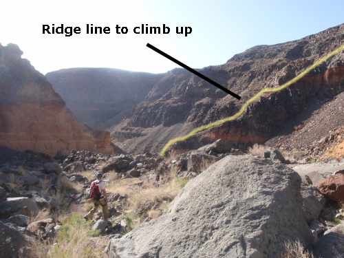
This is a picture of the ridge you are looking for to climb up
out of the canyon.
After everyone is up the first 60 feet or so where you can safely
regroup, everyone can safely travel together. The rest of the way
up is just a slow slog up a dirt and rock slope out of the canyon.
The total elevation gain of the ridge is about 500 feet over about
900 horizontal feet.
From the top of the ridge (wRainbowRP-4), walk due west up the
slight slope about 0.2 miles to where you parked the exit vehicle (PkRainbow-Mid).
If you did not park an exit vehicle you will then need to turn right
at the high way and walk back to the entry vehicle.
Downloadable GPX files
available at
BG-Gear Store
(easier than manual entry and a great way to support
Bluugnome).
Waypoint naming convention and map symbol information can be found on the Glossary page.
Elevations are approximate.
BEFORE
manually entering coordinates set your system to WGS84 datum and Lat/Lon hddd.ddddd° coordinate format.
Inconsistent datum's and coordinate formats will result in location errors.
Click to show / expand the list of waypoints below........
| Rainbow 1 - Approach |
- PkRainbow-Tp
Lat/Lon (WGS84): N 36.35993
W -117.57929
Elev: 4,600 Feet
Park near hear to start the route down to Rainbow Canyon.
- wRainbowRP-1
Lat/Lon (WGS84): N 36.36065
W -117.57985
Elev: NaN Feet
Old dirt road you will be following becomes very obvious here about 300 feet after leaving the parking spot.
- wRainbowRP-2
Lat/Lon (WGS84): N 36.36200
W -117.58058
Elev: NaN Feet
Dirt road crosses over a wash here.
- wRainbowRP-3
Lat/Lon (WGS84): N 36.36644
W -117.57139
Elev: 4,370 Feet
Drop into a large wide open wash. This is the main wash leading down to Rainbow Canyon. Travel down canyon (south east) toward the head of Rainbow.
- yRainbowTp
Lat/Lon (WGS84): N 36.36520
W -117.57069
Elev: 4,320 Feet
Top entry for Rainbow Canyon. There is a drop here of about 20 feet that is down climbed LDC. The drop is in a section of brown and black volcanic rock.
|
| Rainbow 2 - The Canyon and Exit |
- yRainbowTp
Lat/Lon (WGS84): N 36.36520
W -117.57069
Elev: 4,320 Feet
Top entry for Rainbow Canyon. There is a drop here of about 20 feet that is down climbed LDC. The drop is in a section of brown and black volcanic rock.
- dRainbowR1
Lat/Lon (WGS84): N 36.36497
W -117.57062
Elev: NaN Feet
Rap 1 - Rainbow Canyon. Anchored from a large rock RDC and drops about 95 feet down a mostly vertical wall.
- dRainbowR2-3
Lat/Lon (WGS84): N 36.36238
W -117.57023
Elev: 4,200 Feet
Raps 2 and 3 - Rainbow Canyon.
Rap 2 anchored from a large cairn anchor about 20 back from the rap and drops about 150 feet (170 feet back to the anchor).
Rap 3 is anchored from a cairn anchor and drops about 70 feet down a vertical wall. The rock along rap 3 is very colorful and striped resembling a rainbow.
- yRainbowBt
Lat/Lon (WGS84): N 36.35892
W -117.56777
Elev: 3,860 Feet
Bottom exit of Rainbow Canyon. This is at the bottom of a ridge RDC with colorful horizontal stripes. The exit out of the canyon is to climb up the ridge.
- wRainbowRP-4
Lat/Lon (WGS84): N 36.35809
W -117.57046
Elev: 4,332 Feet
Top of the ridge that climbs up out of Rainbow Canyon for the exit.
- PkRainbow-Mid
Lat/Lon (WGS84): N 36.35829
W -117.57452
Elev: 4,458 Feet
Park here to leave an exit vehicle when exiting Rainbow Canyon from shortly below the technical section. This is next to a guard rail with room for about 3 or 4 cars.
|