Canyoneering Route Description
Grotto Canyon - Layer Fork - 4A III
Death Valley National Park,
California.
12-28-13, 7 people, 1 Day (Travel time in route 7.25 hours)

Time Required - 7 to 9 hours
Distance - 5.7 miles Total, 2.3 miles Technical
Rappels - 12 Rappels, Longest Rappel 115 feet.
Elevation Range - 680 - 3380 Feet
Shuttle Required - No Vehicle - High Clearance, 4WD if bad road conditions
Permit Required - No
Rappelling and anchor gear, Ropes and or pull cords for rappels up
to 115 feet and 80 feet of 1 inch webbing for sling placement.
The Layer Fork of Grotto Canyon is very scenic in a few
spots where you cut through upturned rock layers sitting vertically. There
is also a lot more going on with downclimbs and rappels in this Layer Fork as
opposed to the not very interesting Not So Much Fork to the east. If you
are going to choose a fork of Grotto to descend, I recommend this one.
The Layer Fork of Grotto was rated a 4 in technical
difficulty only because knot chalk anchors have been used in a couple spots.
These drops can be anchored suing rocks or cairn anchors but you will need
to farm the rocks. If no knot chalk anchors are used this would be a
technical canyon rated at 3.
There are multiple forks of Grotto and I have only been
along on two of them. One we called the Not So Much fork because it was not
a fun route. The other we called the Layer Fork because the route was more
fun and the canyon cut through some very beautiful layers of rock.
Thanks to Rick Kent for inviting us along on the trip to explore this fork.
There is one rappel in an entry ravine that is counted
in the rap count. If you prefer to count only the raps in canyon proper
subtract one from my count.
While going over rap 2 and the scrambling / downclimbs
just down canyon of it, do not forget to turn around and look back up canyon
occasionally. The layers you have been going over are extremely scenic.
Farther down in the canyon around raps 5 and are more very cool looking
upturned layers of rock to go over. Again do not forget to look back up
canyon occasionally.
The approach route travels up a long ridge over Point
Hideous (name given to the point by Mike Cressman) then down the ridge on
the other side to cross a wide wash. From that wash the route goes south up
more steep ridge then later leaves the ridge and goes over toward the
canyon. The spot to leave the second ridge does not have any good landmarks
to tell you when to stop. Pay careful attention to the description so you
drop in at the right location or use a GPS to get you to the right spot.
To get to the Trailhead
From the store / gas station in Stovepipe Wells (wStovpipeStore)
drive east on Hwy 190 for 1.9 miles to the parking area for the
Mesquite Flat Sand Dunes (pkMesqSndDune). The sand dune
parking lot is a very large paved parking lot with bathrooms and
makes a great place to consolidate people into fewer vehicles if
desired.
From the Mesquite Flat Sand Dunes parking lot continue east on
Hwy 190 for 0.53 miles to a turn off onto a dirt road on the
right (south) which is the turn of for Grotto Canyon (exGrottoDV).
Turn right and drive south up the dirt and gravel road toward
Grotto Canyon which eventually gets more rough as it passes over
alluvial fan and travels directly up the wash.
About 1.2 miles after leaving the highway will be the mouth of
the canyon (GrottoDVMouth). What I marked as the mouth of
the canyon is you begin to have steep hills on BOTH sides of you
(a few hundred feet after you started to have a steep hill on
the right).
The place to park to start the route up the ridge is about 0.37
miles up the wash after getting into the mouth. Park off
to the side (pkGrottoDV) to begin the route.
Note:
There is no signage, markings or good landmarks to
denote the parking and a GPS is helpful finding this spot.
As you drive up fro the mouth of Grotto this parking spot is
near the end of a sweeping left bend and just before a right
bend in the wash as you drive up.
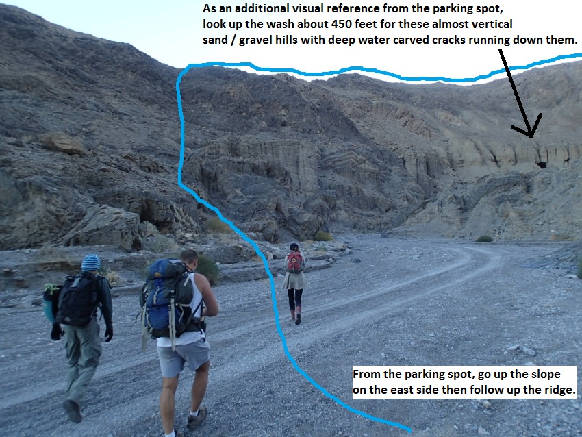
To help visually find the correct spot you should be able to see
some almost vertical sand hills with deep water carved slots /
grooves cut into them on the left side (looking up the wash)
about 450 feet away. The sand hills are visually slightly
obscured by the canyon walls since they are slightly around the
right hand bend in the wash you parked before getting to.
To the left (east) side of the wash almost directly across the
wash from the parking spot the slope up to the ridge above
should look like you can walk / scramble your way up the slopes.
Farther up the wash the canyon walls are too steep to go up.
To leave the Exit Vehicle / Escape Pod
No exit vehicle is needed. This is done as a loop route.
GPS coordinate information listed at the bottom. For information about waypoint naming and map symbols, refer to the
Glossary page.

Click the links for maps of the route.
Map of the drive into the route.
Map of the entire route.
Map of the technical section Zoomed to Upper.
Map of the technical section Zoomed to Lower.
The Approach:
From the parking spot (pkGrottoDV)
go up the slope on the
left (east) side of the
wash. About 500 feet up
the slope you will get
up to the crest of the
ridge on a saddle.
Once on the ridge (GrottoDV01)
turn right and go
southeast up the ridge.
About 0.27 miles up the
ridge it begins to get
steep (GrottoDV02).
Almost 500 feet farther
is an outcropping to
scramble up. As
you scramble up around
the outcropping it seems
to go a little easier to
the right. From
the top of the
outcropping (GrottoDV03)
continue up the ridge
for about 0.25 miles and
cross a shallow saddle
(GrottoDV04). A
little over 500 feet
farther the route up the
ridge tops out briefly
(GrottoDV05).
About 250 feet farther
is another small saddle
(GrottoDV06) then
continue up the ridge
where you will have a
short steep section with
a lot of larger rocks to
walk through and one
small saddle before
getting to the high
point (pPointHideous) on
the approach ridge about
1200 feet away.
The high point on the
ridge (pPointHideous)
was named by Mike
Cressman as Point
Hideous. Follow the more
gently sloped ridge
southeast down the other
side of the peak.
About 0.27 miles down
the ridge from the high
point is another saddle
(GrottoDV07).
About 0.21 miles farther
down the ridge is
another saddle
(GrottoDV08).
About 500 feet farther
is another saddle
(GrottoDV09).
About 300 feet farther
the route crosses over a
large wash (GrottoDV10)
near its top which is
very shallow this high
up. Continue south
across the wide wash
then start up the steep
slope / ridge to the
south.
Note:
As you go over to the
slope you will see a
gully going up just to
the left of the more
rocky terrain. Start up
that gully for easier
travel but you will soon
need to move over onto
the more rocky terrain.
About 450 feet up the
slope is the top end of
the gully (GrottoDV11)
where you need to move
over to the right a bit
and continue up the
ridge in more rocky
terrain with a couple
spots of light
scrambling. About
650 feet farther up is a
small flat zone
(GrottoDV12) for a tiny
break in the steep
grade. About 1000
feet farther up the
grade gets steeper
(GrottoDV13) and more
rocky. Going up the
crest of the ridge here
involves some light 3rd
class scrambling and
looks more difficult
than it is. A few
hundred feet farther and
it becomes a walk again
on more gentle slopes.
Note:
It is possible
to contour around this
on the right side but it
is not fun travel and
going up the ridge is
preferred. Ask me how I
know this.
When you get to the top
of the 3rd class
scrambling and the grade
becomes more gentle
(GrottoDV14), continue
up the ridge about 0.24
miles to the start of a
semi level section
(GrottoDV15) where you
can see see a wide
mellow saddle a bit
lower than you are to
the right (west) about
1000 feet away. The
drainage running down to
the north from that
saddle is the Not So
Much Fork of Grotto. The
Layer Fork of Grotto is
one more drainage over
to the west. Leave the
ridge hear and contour
over to that saddle.
Contour around and route
find your way over to
that saddle.
When you have dropped
down and contoured over
to the saddle (yGrottoNSMTp)
you are on a wide saddle
and at the start of both
the route to the Not So
Much Fork of Grotto and
the Layer Fork of
Grotto.
Note:
To drop into the Not So
Much Fork follow down
the drainage to the
north.
To
continue over to the
Layer Fork of Grotto
follow down the wide
slope to the west which
slowly starts to turn
into a minor drainage.
The Canyoneering / Technical Section:
From the saddle (yGrottoNSMTp)
to continue over to the
Layer Fork, follow down
the wide slope to the
west which slowly starts
to turn into a minor
drainage.
About 400 feet from the
saddle the wash begins
to narrow a little
(GrottoLayer01) and have
some rocks to walk
around.
About 180 feet farther
the wash starts to drop
very steeply
(GrottoLayer02). With
two drops of 15 each
near the top. The first
is an easy scramble or
bypassed LDC and the
second will be
moderately difficult. A
few more short scramble
of about 5 feet each to
a rappel. About 160 feet
farther is a rap 1.
Rap 1 (dGrottoLyrR01) is
anchored from a rock
pile and drops about 20
feet. It may be possible
to downclimb this rap
but it would be
difficult and exposed.
About 100 feet after rap
1 is a moderately
difficult downclimb of
about 15 feet
(GrottoLayer03).
About 200 feet farther
the side drainage used
to get to here meets the
wash (yGrottoLayerTp)
and you are in the main
canyon of the Layer
Fork. Turn right and go
north down canyon.
About 800 feet down
canyon is Rap 2.
Rap 2 (dGrottoLyrR02) is
anchored LDC about head
high from a pinch
between rocks and drops
about 60 feet down a
mostly vertical wall
with small ledges formed
by a series of upturned
layers of rock.
Just after rap 2 is a
moderately difficult
downclimb of about 35
feet that also has
little ledges formed by
a series of upturned
rock layers.
Shortly down canyon are
more easy downclimbs
over another section
going over more upturned
layers of rock
(GrottoLayer04). Then
wash walking down to rap
3.
Rap 3 (dGrottoLyrR03) is
anchored RDC from a
cairn anchor and uses
about 115 feet of rope
over 2 stages with a
long horizontal section
between stages.
About 375 feet down
canyon is a series of 3
drops to downclimb
(GrottoLayer05). 1st is
about 12 feet and can be
bypassed RDC, second is
about 12 feet and is
downclimbed through a
rabbit hole down under a
boulder, 3rd is almost
about 17 feet with a
ledge about 5 feet up
from the bottom. A
couple of the downclimbs
are moderately difficult
and may require a
partner assist for some.
About 250 feet down
canyon is rap 4.
Rap 4 (dGrottoLyrR04) is
anchored from a large
cairn anchor and drops
about 25 feet down a
water carved flute. The
previous anchor was a
knot chalk on the RDC
side about head high in
a crack.
About 80 feet down
canyon is the start of a
winding narrows
(GrottoLayer06) that
starts with a downclimb
of about 10 feet that is
a little difficult under
a boulder and will
likely require a partner
assist. The winding slot
after the downclimb is
short and opens up to
wash walking again.
About 0.22 miles down
canyon is rap 5.
Rap 5 (dGrottoLyrR05) is
anchored RDC from a
redirected knot chalk
and drops about 12 feet
down kind of a flute
formed cutting through
an upturned layer of
rock. Can bypass the rap
by downclimbing around
to the LDC side.
About 230 feet down
canyon is a drop
(GrottoLayer07) where
going down the water
course is a drop of
about 6 feet followed by
a pretty spicy downclimb
of about 15 feet.
However this drop can be
made easier and WAY more
fun / scenic by
downclimbing the first 6
feet then climb out on
the RDC side you get
drop over onto one of
the large upturned rock
layers and walk /
scramble down on its
edge to the canyon
floor. This is a fun
downclimb as you see
what you are walking on.
Wash walking and a few
easy scrambles over
rocks before reaching
rap 6.
Rap 6 (dGrottoLyrR06) is
anchored RDC from a
pinch point between
boulders and uses about
85 feet of rope as it
drops over 2 subtle
stages down slightly
sloped wall.
Just down canyon of rap
6 is a drop of about 35
feet that can be
bypassed by climbing
around on the RDC side.
Rap 7 is a little over
300 feet down canyon.
Rap 7 (dGrottoLyrR07-9)
is anchored LDC from
large boulder embedded
in the wash and drops
about 85 feet with an
awkward start and free
hanging most of the way
down. Be careful at the
top of rap 7 since it is
on a big false floor.
Care should be taken to
be prepared for the
floor to crumble away.
Rap 8 down canyon of rap
7 about 40 feet,
anchored from a cairn
style anchor and drops
about 85 feet and is not
free hanging at all.
Rap 9 down canyon of rap
8 about 40 feet,
anchored RDC from a
pinch point about 15
feet back from the drop
and drops about 20 feet.
This rap can be
downclimbed but is
difficult and sketchy.
Just after rap 9 the
canyon makes a very
sharp left hand bend and
feels like it almost
makes a U-turn is a
downclimb of about 8
feet that is easiest on
the LDC side with wash
walking down canyon
after it.
About 300 feet down
canyon is rap 10.
Rap 10 (dGrottoLyrR10)
is anchored from a rock
protruding from the
floor about 20 feet back
and drops about 40 feet.
About 0.2 miles farther
a junction comes in from
the left (jGrottoOther)
Rick Kent has descended
this other fork and I do
not know what he named
it.
For a side trip, you can
walk up this other fork
about 650 feet to the
lower end of a narrows
then go up that narrows
about 300 more feet to
the bottom of the final
rap in that fork.
About 850 feet down
canyon is the start of a
narrows (GrottoLayer08)
about 450 feet long.
Shortly into the narrows
is an easy downclimb of
about 8 feet then
shortly after is the
next rap. About
100 feet down canyon is
rap 11.
Rap 11 (dGrottoLyrR11)
you can silmul-rap by
stringing the rope over
a large boulder at the
top of the drop and
drops about 15 feet.
This rap can be
downclimbed but will
likely need a partner
assist so sending
someone down on eat
anchor may be the best
option. Continue wash
walking in the narrows
with 5 or 6 more short
and easy scramble /
downclimbs.
Almost 300 feet farther
is a 450 feet long
narrows where you
continue wash walking
down canyon. When
the narrows opens up
(GrottoLayer09) it is
about 0.25 miles down to
rap 12 with one easy
downclimb of about 6 to
8 feet along the way.
Rap 12 (dGrottoLyrR12)
is anchored using either
a rock in the wash or a
knot chalk about 10 feet
back on the RDC side and
drops about 60 feet. At
the bottom of this rap
is what is known as The
Grotto and people
commonly hike up to the
base of this rappel.
Note:
From the top of this rap
you can bypass on the
RDC side following a
ledge then walking the
RDC rim following the
occasional use trail
then drop back to the
canyon floor a few
hundred feet down
canyon. The bypass goes
around the final rappel
and the Grotto. section.
About 0.27 miles down
canyon is the confluence
where the Not So Much
Fork of Grotto joins in
from the RDC side (jLayer-NSM).
About 500 feet farther
down canyon is the top
of a narrows
(GrottoLayer10) about
200 foot long with 3
moderately difficult
drops of 6, 10 and 15
feet. A partner assist
will likely be needed on
the 10 foot drop.
Optionally you can route
find your way up and
around a long ways RDC
to bypass this narrows.
The Exit:
When the
final small narrows
widens out
(yGrottoDV-Bt) walk down
the wash about 0.4 miles
back to the cars.
Downloadable GPX files
available at
BG-Gear Store
(easier than manual entry and a great way to support
Bluugnome).
Waypoint naming convention and map symbol information can be found on the Glossary page.
Elevations are approximate.
BEFORE
manually entering coordinates set your system to WGS84 datum and Lat/Lon hddd.ddddd° coordinate format.
Inconsistent datum's and coordinate formats will result in location errors.
Click to show / expand the list of waypoints below........
| Grotto DV - Layer Fork 1 - Drive to Trailhead |
- wStovpipeStore
Lat/Lon (WGS84): N 36.60663
W -117.14688
Elev: 0 Feet
Convenience store / gas station at Stovepipe Wells.
- pkMesqSndDune
Lat/Lon (WGS84): N 36.60625
W -117.11505
Elev: -14 Feet
Parking area for the Mesquite Flat Sand Dunes. Large parking lot with bathrooms.
- exGrottoDV
Lat/Lon (WGS84): N 36.60439
W -117.10572
Elev: NaN Feet
Turn off to dirt road going to Grotto Canyon. High clearance recomended, passenger cars will have trouble.
- GrottoDVMouth
Lat/Lon (WGS84): N 36.58836
W -117.11026
Elev: NaN Feet
This is the mouth of Grotto Canyon where it opens up to alluvial fan. On the drive up to here from the road this is where you begin to have steep hills on BOTH sides of you (a few hundred feet after you started to have a steep hill on the right).
- pkGrottoDV
Lat/Lon (WGS84): N 36.58460
W -117.10608
Elev: 680 Feet
Parking spot to start the Grotto route. This is about 0.37 miles up into Grotto from the mouth and is near the end of a sweeping left bend and just before a right bend in the wash as you drive up. Park off to the side. There is no signage, markings or good landmarks and a GPS is helpful finding this spot.
To begin the route up, go up the slope on the left (east) side of the wash. About 500 feet up the slope you will get up to the crest of the ridge on a saddle.
|
| Grotto DV - Layer Fork 2 - Approach |
- pkGrottoDV
Lat/Lon (WGS84): N 36.58460
W -117.10608
Elev: 680 Feet
Parking spot to start the Grotto route. This is about 0.37 miles up into Grotto from the mouth and is near the end of a sweeping left bend and just before a right bend in the wash as you drive up. Park off to the side. There is no signage, markings or good landmarks and a GPS is helpful finding this spot.
To begin the route up, go up the slope on the left (east) side of the wash. About 500 feet up the slope you will get up to the crest of the ridge on a saddle.
- GrottoDV01
Lat/Lon (WGS84): N 36.58564
W -117.10451
Elev: NaN Feet
Saddle. Turn right and go southeast up the ridge.
- GrottoDV02
Lat/Lon (WGS84): N 36.58294
W -117.10179
Elev: NaN Feet
Ridge begins to get steep.
- GrottoDV03
Lat/Lon (WGS84): N 36.58248
W -117.10006
Elev: NaN Feet
Top of a large outcropping to scramble up. As you scramble up around the outcropping it seems to go a little easier to the right.
- GrottoDV04
Lat/Lon (WGS84): N 36.57997
W -117.09718
Elev: NaN Feet
Crossing a shallow saddle.
- GrottoDV05
Lat/Lon (WGS84): N 36.57885
W -117.09593
Elev: NaN Feet
Route up the ridge tops out briefly.
- GrottoDV06
Lat/Lon (WGS84): N 36.57845
W -117.09535
Elev: NaN Feet
Saddle after the brief top out. Continue up the ridge where you will have a short steep section with a lot of larger rocks to walk through and one small saddle before getting to the high point on the approach ridge about 1200 feet away.
- pPointHideous
Lat/Lon (WGS84): N 36.57758
W -117.09163
Elev: 2,110 Feet
Top out of the approach ridge up to Grotto. Cressman named this peak Point Hideous. Follow the more gently sloped ridge southeast down the other side of the peak.
- GrottoDV07
Lat/Lon (WGS84): N 36.57527
W -117.08784
Elev: NaN Feet
Saddle along the ridge.
- GrottoDV08
Lat/Lon (WGS84): N 36.57281
W -117.08586
Elev: NaN Feet
Saddle along the ridge.
- GrottoDV09
Lat/Lon (WGS84): N 36.57150
W -117.08587
Elev: NaN Feet
Saddle along the ridge.
- GrottoDV10
Lat/Lon (WGS84): N 36.57073
W -117.08558
Elev: 1,970 Feet
Crossing over a large wash near its top which is very shallow this high up. Continue south across the wide wash then start up the steep slope / ridge to the south.
As you go over to the slope you will see a gully going up just to the left of the more rocky terrain. Start up that gully for easier travel but you will soon need to move over onto the more rocky terrain.
- GrottoDV11
Lat/Lon (WGS84): N 36.56961
W -117.08578
Elev: NaN Feet
Top end of the gully where you need to move over to the right a bit and continue up the ridge in more rocky terrain with a couple spots of light scrambling.
- GrottoDV12
Lat/Lon (WGS84): N 36.56824
W -117.08717
Elev: NaN Feet
Small flat zone for a tiny break in the steep grade.
- GrottoDV13
Lat/Lon (WGS84): N 36.56567
W -117.08849
Elev: NaN Feet
Grade gets steeper and more rocky. Going up the crest of the ridge here involves some light 3rd class scrambling and looks more difficult than it is. A few hundred feet fartehr and it becomes a walk again on more gentle slopes.
Note:
It is possible to contour around this on the right side but it is not fun travel and going up the ridge is preferred. Ask me how I know this.
- GrottoDV14
Lat/Lon (WGS84): N 36.56433
W -117.08820
Elev: 2,980 Feet
Top of the 3rd class scrambling and the grade becomes more gentle.
- GrottoDV15
Lat/Lon (WGS84): N 36.56094
W -117.08910
Elev: 3,339 Feet
Start of a semi level section. From here you can see a wide mellow saddle a bit lower than you are to the right (west) about 1000 feet away. The drainage running down to the north from that saddle is the Not So Much Fork of Grotto. The Layer Fork of Grotto is one more drainage over to the west. Leave the ridge hear and contour over to that saddle. Contour around and route find your way over to that saddle.
- yGrottoNSMTp
Lat/Lon (WGS84): N 36.56069
W -117.09240
Elev: 3,167 Feet
Top of Grotto - Not So Much Fork. This is a wide saddle at the top of the canyon.
To drop into the Not So Much Fork follow down the drainage to the north. Down the drainage from here is easy travel down moderately steep and wide ravine.
To continue over to the Layer Fork of Grotto follow down the wide slope to the west which slowly starts to turn into a minor drainage.
|
| Grotto DV - Layer Fork 3 - The Canyon |
- yGrottoNSMTp
Lat/Lon (WGS84): N 36.56069
W -117.09240
Elev: 3,167 Feet
Top of Grotto - Not So Much Fork. This is a wide saddle at the top of the canyon.
To drop into the Not So Much Fork follow down the drainage to the north. Down the drainage from here is easy travel down moderately steep and wide ravine.
To continue over to the Layer Fork of Grotto follow down the wide slope to the west which slowly starts to turn into a minor drainage.
- GrottoLayer01
Lat/Lon (WGS84): N 36.56015
W -117.09342
Elev: NaN Feet
Wash begins to narrow a little and have some rocks to walk around.
- GrottoLayer02
Lat/Lon (WGS84): N 36.56041
W -117.09395
Elev: NaN Feet
Wash starts to drop very steeply. Here near the top are two drops of 15 each. The first is an easy scramble or bypassed LDC and the second will be moderately difficult. A few more short scramble of about 5 feet each to a rappel.
- dGrottoLyrR01
Lat/Lon (WGS84): N 36.56041
W -117.09441
Elev: NaN Feet
Rap 1 - Grotto - Layer Fork. Anchored from a rock pile and drops about 20 feet. It may be possible to downclimb this rap but it would be difficult and exposed.
- GrottoLayer03
Lat/Lon (WGS84): N 36.56039
W -117.09481
Elev: NaN Feet
Moderately difficult downclimb of about 15 feet.
- yGrottoLayerTp
Lat/Lon (WGS84): N 36.56069
W -117.09544
Elev: 2,830 Feet
Top of the Layer Fork of Grotto Canyon where a side drainage used to get to here meets the wash. Turn right and go north down canyon.
- dGrottoLyrR02
Lat/Lon (WGS84): N 36.56174
W -117.09599
Elev: NaN Feet
Rap 2 - Grotto - Layer Fork. Anchored LDC about head high from a pinch between rocks and drops about 60 feet down a mostly vertical wall with small ledges formed by a series of upturned layers of rock.
Just after rap 2 is a moderately difficult downclimb of about 35 feet that also has little ledges formed by a series of upturned rock layers.
- GrottoLayer04
Lat/Lon (WGS84): N 36.56199
W -117.09625
Elev: NaN Feet
Easy downclimbs over another section going over more upturned layers of rock. Then wash walking down to rap 3.
- dGrottoLyrR03
Lat/Lon (WGS84): N 36.56338
W -117.09651
Elev: NaN Feet
Rap 3 - Grotto - Layer Fork. Anchored RDC from a cairn anchor and uses about 115 feet of rope over 2 stages with a long horizontal section between stages.
- GrottoLayer05
Lat/Lon (WGS84): N 36.56376
W -117.09737
Elev: NaN Feet
Series of 3 drops to downclimb. 1st is about 12 feet and can be bypassed RDC, second is about 12 feet and is downclimbed through a rabbit hole down under a boulder, 3rd is almost about 17 feet with a ledge about 5 feet up from the bottom. A couple of the downclimbs are moderately difficult and may require a partner assist for some.
- dGrottoLyrR04
Lat/Lon (WGS84): N 36.56413
W -117.09808
Elev: NaN Feet
Rap 4 - Grotto - Layer Fork. Anchored from a large cairn anchor and drops about 25 feet down a water carved flute. The previous anchor was a knot chalk on the RDC side about head high in a crack.
- GrottoLayer06
Lat/Lon (WGS84): N 36.56430
W -117.09833
Elev: NaN Feet
Winding narrows starts with a downclimb of about 10 feet that is a little difficult under a boulder and will likely require a partner assist. The winding slot after the downclimb is short and opens up to wash walking again.
- dGrottoLyrR05
Lat/Lon (WGS84): N 36.56600
W -117.09917
Elev: NaN Feet
Rap 5 - Grotto - Layer Fork. Anchored RDC from a redirected knot chalk and drops about 12 feet down kind of a flute formed cutting through an upturned layer of rock. Can bypass the rap by downclimbing around to the LDC side.
- GrottoLayer07
Lat/Lon (WGS84): N 36.56667
W -117.09925
Elev: NaN Feet
A drop where going down the water course is a drop of about 6 feet followed by a pretty spicy downclimb of about 15 feet. However this drop can be made easier and WAY more fun / scenic by downclimbing the first 6 feet then climb out on the RDC side you get drop over onto one of the large upturned rock layers and walk / scramble down on its edge to the canyon floor. This is a fun downclimb as you see what you are walking on.
Wash walking and a few easy scrambles over rocks before reaching rap 6.
- dGrottoLyrR06
Lat/Lon (WGS84): N 36.56698
W -117.09974
Elev: NaN Feet
Rap 6 - Grotto - Layer Fork. Anchored RDC from a pinch point between boulders and uses about 85 feet of rope as it drops over 2 subtle stages down slightly sloped wall.
Just down canyon of rap 6 is a drop of about 35 feet that can be bypassed by climbing around on the RDC side.
- dGrottoLyrR07-9
Lat/Lon (WGS84): N 36.56763
W -117.10061
Elev: NaN Feet
Raps 7 thru 9 - Grotto - Layer Fork.
Rap 7 anchored LDC from large boulder embedded in the wash and drops about 85 feet with an awkward start and free hanging most of the way down. Be careful at the top of rap 7 since it is on a big false floor. Care should be taken to be prepared for the floor to crumble away.
Rap 8 down canyon of rap 7 about 40 feet, anchored from a cairn style anchor and drops about 85 feet and is not free hanging at all.
Rap 9 down canyon of rap 8 about 40 feet, anchored RDC from a pinch point about 15 feet back from the drop and drops about 20 feet. This rap can be downclimbed but is difficult and sketchy.
Just after rap 9 the canyon makes a very sharp left hand bend and feels like it almost makes a U-turn is a downclimb of about 8 feet that is easiest on the LDC side with wash walking down canyon after it.
- dGrottoLyrR10
Lat/Lon (WGS84): N 36.56792
W -117.10164
Elev: NaN Feet
Rap 10 - Grotto - Layer Fork. Anchored from a rock protruding from the floor about 20 feet back and drops about 40 feet.
- jGrottoOther
Lat/Lon (WGS84): N 36.57046
W -117.10307
Elev: 1,619 Feet
When walking down Grotto Layer Fork another one of the Grotto Canyon Forks joins in here from the LDC side. Rick Kent has descended this other fork and I do not know what he named it.
You can walk up this other fork about 650 feet to the lower end of a narrows then go up that narrows about 300 more feet to the bottom of the final rap in that fork.
- GrottoLayer08
Lat/Lon (WGS84): N 36.57196
W -117.10177
Elev: NaN Feet
Start of a narrows about 450 feet long. Shortly into the narrows is an easy downclimb of about 8 feet then shortly after is the next rap.
- dGrottoLyrR11
Lat/Lon (WGS84): N 36.57216
W -117.10148
Elev: NaN Feet
Rap 11 - Grotto - Layer Fork. You can silmul-rap by stringing the rope over a large boulder at the top of the drop and drops about 15 feet. This rap can be downclimbed but will likely need a partner assist so sending someone down on eat anchor may be the best option. Continue wash walking in the narrows with 5 or 6 more short and easy scramble / downclimbs.
- GrottoLayer09
Lat/Lon (WGS84): N 36.57302
W -117.10130
Elev: NaN Feet
Lower end of a narrows about 450 feet long where you continue wash walking down canyon to the final rap with one easy downclimb of about 6 to 8 feet along the way.
- dGrottoLyrR12
Lat/Lon (WGS84): N 36.57596
W -117.10064
Elev: NaN Feet
Rap 12 - Grotto - Layer Fork. Anchored using either a rock in the wash or a knot chalk about 10 feet back on the RDC side and drops about 60 feet. At the bottom of this rap is what is known as The Grotto and people commonly hike up to the base of this rappel.
Note:
From the top of this rap you can bypass on the RDC side following a ledge then walking the RDC rim following the occasional use trail then drop back to the canyon floor a few hundred feet down canyon. The bypass goes around the final rappel and the Grotto. section.
- jLayer-NSM
Lat/Lon (WGS84): N 36.57833
W -117.10232
Elev: 930 Feet
Confluence of the Layer and Not So Much forks of Grotto where they join. Continue wash walking down canyon.
- GrottoLayer10
Lat/Lon (WGS84): N 36.57972
W -117.10259
Elev: NaN Feet
Narrows about 200 foot long with 3 moderately difficult drops of 6, 10 and 15 feet. A partner assist will likely be needed on the 10 foot drop. Optionally you can route find your way up and around a long ways RDC to bypass this narrows.
- yGrottoDV-Bt
Lat/Lon (WGS84): N 36.57995
W -117.10317
Elev: 860 Feet
Bottom of Grotto Canyon just after the last short narrows with a few downclimbs. Walk down the wash back to the cars.
|
| Grotto DV - Layer Fork 4 - Exit |
- yGrottoDV-Bt
Lat/Lon (WGS84): N 36.57995
W -117.10317
Elev: 860 Feet
Bottom of Grotto Canyon just after the last short narrows with a few downclimbs. Walk down the wash back to the cars.
- tGrottoCyn
Lat/Lon (WGS84): N 36.58228
W -117.10404
Elev: 770 Feet
Trailhead for Grotto Canyon. sings in wash saying no driving up past this point.
- pkGrottoDV
Lat/Lon (WGS84): N 36.58460
W -117.10608
Elev: 680 Feet
Parking spot to start the Grotto route. This is about 0.37 miles up into Grotto from the mouth and is near the end of a sweeping left bend and just before a right bend in the wash as you drive up. Park off to the side. There is no signage, markings or good landmarks and a GPS is helpful finding this spot.
To begin the route up, go up the slope on the left (east) side of the wash. About 500 feet up the slope you will get up to the crest of the ridge on a saddle.
|