Canyoneering Route Description
Coffin Canyon - 3A II
Death Valley National Park, California.
Note:
Various routes into Coffin Canyon have been explored before finding
the best route. Pictures prior to 2010 used approach routes no
longer in use and should not be referenced to get a feel for the
approach. Pictures from 02-28-10 and forward will use the preferred
approach route. Pictures from 03-09-08 are on the route for both
Upper and Lower Coffin Canyon starting via Dante's View area.
03-09-08, 6 people, 1 Day (Travel time in route 8.65 hours) Upper and Lower
Coffin Canyon.

11-10-08, 2 people, 1 Day (Travel time in route 6.25 hours) Alternate
approach (not recommended).
04-18-09, 1 person, 1 Day (Travel time in route 6.25 hours) Alternate approach (not recommended).
02-28-10, 6 people, 1 Day (Travel time in route 6.25 hours)
Preferred approach.
12-23-10, 3 people, 1 Day (Travel time in route 5.25 hours)
Preferred approach.
12-25-11, 5 Elves and 1 Reindeer , 1 Day (Travel time 6.2 hours) Preferred
approach.
10-29-12, 4 people, 1 Day (Travel time in route 11 hours) Upper and Lower
Coffin Canyon taking it slow for the Popular Mechanics guys.
02-17-13, 34 people, 1 Day (Travel time in route 7.75 hours)
Preferred approach. (Coffin Crush - How Many People Can We ....)
Time Required - 5 to 7 hours
Distance - 3.7 miles Total, 1.2 miles Technical
Rappels - 5 Rappels, Longest Rappel 190 feet.
Elevation Range - -260 feet below sea level -
1675 Feet
Shuttle Required -No Vehicle - Passenger
Permit Required - No
If you decide to do the full route consisting of Upper and Lower Coffin
Canyon, the route will be 8.7 miles and have two more raps.
For more on this see a note in the General Comments section.
Rappelling and anchor gear, Ropes and or pull cords for rappels up
to 190 feet and 60 feet of 1 inch webbing for sling placement.
ATTENTION!!
Death Valley is considering a new permit system in response to the impact of the growing popularity of Canyoneering.
Lets continue to show the park just how respectful we can be to our environment.
Specific issues the park is concerned about:
1. Anchors: Bolting is Illegal in Death Valley National Park! Do Not Add Bolts. Natural anchor options are abundant.
Recent illegal bolts have popped up in Helios and Rainbow Canyons.
2. Poop: Dig a cathole at least 6 inches deep and 200 yards from any water source or campsite. Pack out all toilet paper.
3. Collecting fire wood is illegal, just don't do it!
Other basics:
Avoid walking in water when possible (Willow Canyon, etc).
Hike on durable surfaces and previously worn paths (avoid trampling vegetation or fragile soil crusts).
Pack out all trash including organic material (including seed shells, apple cores, orange peels, etc).
More info can be found here: http://www.nps.gov/deva/planyourvisit/backcamp.htm
Lets keep this wonderful resource pristine so that we may continue to enjoy the canyons with limited regulations!
The Copper Canyon area in Death Valley is closed. This closure
effects this route. For
more information check out the
Copper Canyon Closure Page.
Note about doing the full Coffin Canyon route:
If you want to see Upper and Lower Coffin Canyon I do not recommend
doing the full route. Instead follow this route description to
do only Lower Coffin Canyon (absolutely the best part). Then
follow the route description to do Styx Canyon. Styx Canyon
uses Upper Coffin Canyon as the approach so doing Styx will show you
through Upper Coffin Canyon. Doing it this was there is only a
3.5 mile stretch you do not get to walk in. That 3.5 miles is
a very long boring walk down a very wide open wash. By doing
Lower Coffin Canyon then Styx Canyon, you get to see all the cool
stuff, do two canyons and avoid a long 3.5 mile walk down a wide open wash.
Doing upper and lower Coffin together will also introduce the need
for a long shuttle.
There are other routes into Lower Coffin Canyon. Some of these
routes cross into the Copper Canyon Closure Area and should not be
followed. Some rangers in Death Valley get alarmed if they
see cars parked near Copper Canyon. Using this route will keep
you and your vehicle far away from Copper Canyon so there should be
no concerns of violating any boundaries of the closure.
If you park too close to Copper Canyon, you just might have a ranger
and highway patrol waiting for you at your car. If this happens
they will search any data on your GPS, look through ALL the pictures
on your camera and search you and everything you have (just short
of a strip search) before sending you on your way. This is all to
be sure you were not somewhere you were not supposed to be. How do
I know this you ask? Because I got the royal treatment coming back
from a solo trip to look over optional different approach routes.
The approach described here ascends the ridge on the immediate south
side of Coffin Canyon. The steepest part is from the mouth of
Coffin Canyon up to peak 1676. This section ascends a little
over 1700 feet in less than a mile.
Rap 1 is interesting in that the wash leading to the top of and away
from the bottom is flat and level. But the rap itself is down a
sheer wall 190 feet. I love the contrast of this. It is as though
someone took a flat gravel side walk and dropped part of it 190
feet. This is one of my favorite rappels in Death Valley
because of the contrast.
In the canyon are enough down climbs to keep you interested. The
first 2 drops are 40 and 30 feet and do not need to be rappelled.
Instead climb around each RDC. After the two drops you will
get to the top of rap 1. Some have set anchors for these first
2 drops
but these are unnecessary.
To get to the Trailhead
From the intersection of hwy 190 and Bad Water Road (hwy 178),
follow Bad Water Road south about 16 miles to Bad Water. From
Bad Water continue on Bad Water Road 7.3 miles and pull off to
the side of the road. There are no pull outs or parking areas.
Just find a spot on the side of the road to pull over and park.
This is about 0.4 miles due south of the exit from Coffin
Canyon.
To leave the Exit Vehicle / Escape Pod
No exit vehicle is needed. This is done as a loop route.
GPS coordinate information listed at the bottom. For information about waypoint naming and map symbols, refer to the
Glossary page.

Click the links for maps of the route.
Map of the entire route.
The Approach:
From where you have parked your vehicle alongside the road (pkCoffinBT),
walk north across the alluvial fan toward the mouth of Coffin
Canyon. On the south side of the mouth of the canyon is a
the start of a ridge (wCofinLwrRP-01) that goes up east, staying
roughly along the south side of Coffin Canyon. The ridge
is what you will be following for the approach to Coffin (lower)
Canyon.
Looking up the ridge from below looks like it is not an easy or
fun route to follow. Surprisingly it is pretty easy travel
although a bit steep. There are a lot of loose rocks along
the route so be careful what you pull or step on.
The start of the climb up on the ridge is steep but is not much
more difficult than walking up stairs with big steps.
About 450 feet along the ridge is a chute that needs to be
scrambled up (wCofinLwrRP-02). This is the first spot you
will need your hands for more than just a quick balance point.
The chute is pretty easy to conquer. After getting up the
chute, the ridge continues just as it had been before, steep
rough and as easy to travel as a set of big stairs.
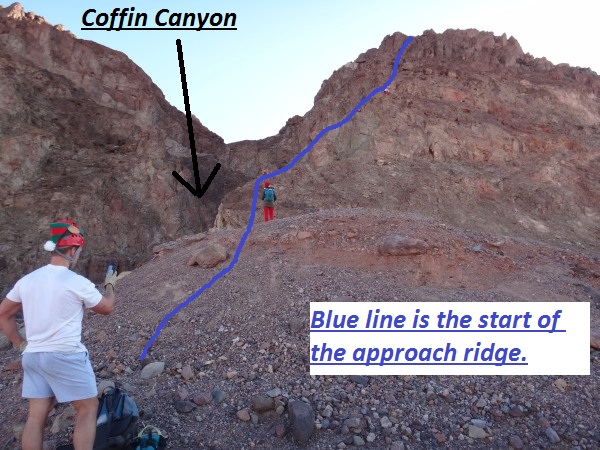
This is the start of the approach ridge.
Note:
When starting up the first part of the ridge it is easy to get
off track. For the first few hundred feet up make a point
of staying close to Coffin Canyon (on your left) and not wander
off to the right too far.
About 200 feet after the chute is a small area along the ridge
that levels off. Then another 800 feet and a faint trail
emerges (wCofinLwrRP-03) running up along the ridge. The
trail continues a long way before fading out again.
Another 0.4 miles up the ridge is the top out on the first major
peak on the ridge (wCofinLwrRP-04). Continue east along
the top of the peak then down the east side. Dropping off
the east side of the peak is a drop with large rocks to scramble
down.
After getting down the other side of the peak walk over to then
across a large saddle (wCofinLwrRP-05). The saddle is
covered in a yellow dirt as opposed to the darker dirt on either
end of it.
After the saddle continue east following the ridge climbing up
to the second major peak on the ridge. This peak is marked
as peak 1676 on some maps. Continue over to the highest
point on the peak (wCofinLwrRP-06). From this point are
great views of the surrounding area and a birds eye look over
the remainder of the route down into Coffin wash.
Looking down and east is a hill below with a green color to it.
Look close and you will be able to see a faint trail running
along its base toward Coffin wash. That trail will be part
of the route. Looking beyond and slightly right (south) of
the green hill is a large white mountain. Looking left
(north) beyond the Coffin wash is a large red mountain with a
slightly yellow top. The view from this peak offers many
different colors on the surrounding hills.
From the peak continue down the east side and start dropping
down toward the green hill. On the way down toward the
green hill will be a ridge line to the left (north) and a wide
shallow ravine to the right (south). The best route is to
continue down hill between the ridge and the ravine.
0.2 miles down from the peak the route will intersect with a
trail (wCofinLwrRP-07) coming in from the south east. Turn
left onto this trail and follow it north east. The trail
quickly turns north and starts down a slope.
About 200 feet along the trail will be a flat spot in the trail
along its drop down the slope (wCofinLwrRP-08). From this
flat spot on the slope, look right (east) for a trail down on
the saddle below. The trail clearly starts up again about
200 feet away on the saddle. Walk down a shallow ravine
about 200 feet to get to the trail the saddle (wCofinLwrRP-09).
Follow the trail a little over 500 feet as it curves north
toward Coffin Wash. The trail fades before reaching the
final drop down into the wash.
Once in Coffin Wash (wCofinLwrRP-10), turn left (northwest) and
start down canyon. About 0.3 miles down the wash will be the
point I have called the "Mouth of the Canyon" which marks the top
of the technical section. The "Mouth of the Canyon" is a large
opening on canyon right (RDC) that looks like a large mouth
ready to swallow anything that gets near it.
The Canyon / Technical Section:
From the Mouth of the Canyon" (yCoffinLowerTp) hike 0.4 miles
down canyon to the first major drop (wCoffinRP-01). It is about
40 feet and can be down climbed around RDC. Some people
have added an
anchor here to rappel. It is much easier to climb around RDC.
Walk up the rock on the right and follow along to a scree slope
leading back down to the main wash. You can be back in the wash
on your way down canyon in less time than it takes to set up the
rappel.
Shortly after is another drop in the water course about 30 feet
that can also be down climbed around RDC (wCoffinRP-02).
Climb up right and over to a drop RDC along the canyon wall.
The drop is easy to down climb since it travels down a a crack
so stemming is pretty simple. The total drop is about 30
feet.
Rap 1 (dCoffinLowerR1) is 300 feet or so after the down climb. Rap 1 is 190 feet and anchored by
2 bolt and hangers. Rap 1 is the longest rappel on the route
and is the best of them, but not because it is the longest. I
like it best because of the sheer drop with flat wash up and
down canyon of it. The wash leading up to Rap 1 is nice, flat
and easy walking in soft gravel. The 190 foot sheer drop is
very abrupt. At the bottom the wash continues down canyon very
flat and has the same feeling of easy walking since it too has a
soft gravel floor. It feels like someone took a nice level gravel
path and just dropped half of it 190 feet right in the middle.
Rap 2 (dCoffinLowerR2) is about 1,000 feet down canyon of rap 1. Rap
2 is
anchored about 30 feet up canyon from the drop from webbing
slung around a medium size boulder. The rap itself drops about
30 feet down a slightly fluted wall. On later visits he
anchor for this has been changed to a large cairn anchor at the
top of the drop. I am noting this to help with keeping on
track with this description.
After a couple hundred feet and a couple easy down climbs is a
more challenging down climb where the canyon turns sharp left
and a large choke stone is wedged overhaed. The down climb drops about 12 feet and looks
intimidating. People should take advantage of a belay for this
down climb. As you get a few feet down there are lots of foot
holds, but they are hard to see. Adding to the difficulty is the
lack of hand holds at the top. Trying to get into position for
the next move is difficult since there are no hand holds to aid
in balance. The last person will likely need a spot to complete this
climb. After getting to the bottom it looks as though it should
not be a problem at all, but looks can be deceiving. Some
parties
have added webbing around a rock RDC to allow raping the down
climb. With a good spot from below the last person can
safely get down this drop. Be sure to look up over head
while in this area to see a large choke stone wedge overhead.
Rap 3 (dCoffinLowerR3) is about 50 feet after this down climb.
To get to the anchors for rap 3, climb down about
8 feet to a ledge were there are 2 bolt and hangers LDC a little
over head high. Rap 3 drops down a fairly smooth rock face
about 30 feet to the soft gravel floor below.
From the bottom of rap 3 the canyon begins to open up with a
couple easy down climbs to mix it up a little. There are
also views of the Death Valley floor in the distance.
Rap 4 (dCoffinLowerR4) is about 1,000 feet down canyon from
rap 3.
Rap 4 drops about 20 feet down a fairly
deep fluted wall. The flute twists a little on the way down. I
found this rap pleasing in some way.
Note:
I have seen a number of various anchor configurations for rap 4
over time. I have seen choke stones in cracks, knot
chocks, climbing nuts and quasi cairn anchors. The one
prefer is a knot chock placed LDC about 5 feet back from the
drop. But who knows what you will find when you get there.
Rap 5 (dCoffinLowerR5) is about 600 after rap 4. Rap 5
is the final rap and is
anchored from another anchor system consisting of webbing slung
around a boulder and backed up with webbing slung around a small
blunt horn. Rap 5 drops about 80 feet down a rough rock wall.
A couple hundred feet below rap 5 the canyon ends and you find
yourself at the top of the alluvial fan for Coffin Canyon
(yCoffinLowerBt).
The Exit:
After exiting the canyon and getting to the alluvial fan turn
left (south) and walk about 0.4 miles back to the car
(pkCoffinBT).
Downloadable GPX files
available at
BG-Gear Store
(easier than manual entry and a great way to support
Bluugnome).
Waypoint naming convention and map symbol information can be found on the Glossary page.
Elevations are approximate.
BEFORE
manually entering coordinates set your system to WGS84 datum and Lat/Lon hddd.ddddd° coordinate format.
Inconsistent datum's and coordinate formats will result in location errors.
Click to show / expand the list of waypoints below........
| Coffin 1 - Drive to Trailhead |
- extBadWatr-190
Lat/Lon (WGS84): N 36.44835
W -116.85247
Elev: 10 Feet
Junction of highway 190 and Badwater Road (178).
- extDesoltnCyn
Lat/Lon (WGS84): N 36.39642
W -116.84753
Elev: -186 Feet
Exit for the road to Desolation Canyon.
- extDevilsGolf
Lat/Lon (WGS84): N 36.29845
W -116.81171
Elev: -200 Feet
Turn off for the Devil's Golf Course. Park here to leave an exit vehicle when doing Brimstone Canyon.
- extNatBridge
Lat/Lon (WGS84): N 36.27404
W -116.79292
Elev: -241 Feet
Exit for the road to the Natural Bridge trailhead.
- sBadWater282
Lat/Lon (WGS84): N 36.23001
W -116.76791
Elev: -282 Feet
Sign at Bad Water Stating 282 feet below sea level
- pkCoffinBT
Lat/Lon (WGS84): N 36.14693
W -116.76678
Elev: -265 Feet
Park here next to the highway to leave the exit vehicle.
|
| Coffin 2 - Approach |
- pkCoffinBT
Lat/Lon (WGS84): N 36.14693
W -116.76678
Elev: -265 Feet
Park here next to the highway to leave the exit vehicle.
- wCofinLwrRP-01
Lat/Lon (WGS84): N 36.15251
W -116.76679
Elev: -70 Feet
Start of a ridge running up to the east the roughly follows the south edge of Coffin Canyon.
- wCofinLwrRP-02
Lat/Lon (WGS84): N 36.15205
W -116.76541
Elev: NaN Feet
A short chute that needs to be scrambled up about 20 feet. Easy scramble up.
- wCofinLwrRP-03
Lat/Lon (WGS84): N 36.15070
W -116.76283
Elev: NaN Feet
Faint path emerges and continues along the ridge for quite a way before fading out.
- wCofinLwrRP-04
Lat/Lon (WGS84): N 36.15014
W -116.75563
Elev: NaN Feet
Top out on first major hill on ridge. Flat area here.
- wCofinLwrRP-05
Lat/Lon (WGS84): N 36.15047
W -116.75470
Elev: NaN Feet
Saddle between the two peaks along the ridge. Yellow dirt.
- wCofinLwrRP-06
Lat/Lon (WGS84): N 36.15122
W -116.75258
Elev: 1,676 Feet
Top out of the second major peak along the ridge. Marked as peak 1676 on some maps.
28-FEB-10 11:36:57AM
- wCofinLwrRP-07
Lat/Lon (WGS84): N 36.15252
W -116.74937
Elev: NaN Feet
Route meets a trail coming in from the south west. Turn left on the trail to follow it north east.
This is where the old route in from Copper Canyon meets the new improved route.
- wCofinLwrRP-08
Lat/Lon (WGS84): N 36.15290
W -116.74883
Elev: NaN Feet
Trail drops down a slope to a flat spot here. Look right (east) to see a faint trail on a saddle below.
- wCofinLwrRP-09
Lat/Lon (WGS84): N 36.15268
W -116.74805
Elev: NaN Feet
Clear easy trail running along a saddle toward Coffin Wash.
- wCofinLwrRP-10
Lat/Lon (WGS84): N 36.15390
W -116.74735
Elev: 1,150 Feet
In Coffin Wash.
- yCoffinLowerTp
Lat/Lon (WGS84): N 36.15620
W -116.75077
Elev: 1,044 Feet
Top Entry for Lower Coffin Canyon. Point where Lower Coffin Canyon begins to narrow and get technical. A large mouth like opening is seen RDC. Looks like it could eat you.
|
| Coffin 3 - The Canyon and Exit |
- yCoffinLowerTp
Lat/Lon (WGS84): N 36.15620
W -116.75077
Elev: 1,044 Feet
Top Entry for Lower Coffin Canyon. Point where Lower Coffin Canyon begins to narrow and get technical. A large mouth like opening is seen RDC. Looks like it could eat you.
- wCoffinRP-01
Lat/Lon (WGS84): N 36.15289
W -116.75579
Elev: NaN Feet
40 foot drop in water course that can be bypassed with a down climb RDC.
- wCoffinRP-02
Lat/Lon (WGS84): N 36.15281
W -116.75674
Elev: NaN Feet
30 foot drop in water course that can be bypassed with a down climb RDC.
- dCoffinLowerR1
Lat/Lon (WGS84): N 36.15267
W -116.75767
Elev: NaN Feet
Rap 1 in Lower Coffin Canyon. 190 feet, anchored from 2 bolt and hangers. This is the first rappel in the lower Coffin Canyon.
- dCoffinLowerR2
Lat/Lon (WGS84): N 36.15239
W -116.76054
Elev: 528 Feet
Rap 2 in Lower Coffin Canyon. 30 feet, anchored from a boulder about 30 feet up canyon or a large cairn anchor at the top of the drop.
- dCoffinLowerR3
Lat/Lon (WGS84): N 36.15253
W -116.76195
Elev: -40 Feet
Rap 3 in Lower Coffin Canyon. 30 feet, anchored from 2 bolt and hangers LDC.
- dCoffinLowerR4
Lat/Lon (WGS84): N 36.15229
W -116.76450
Elev: 100 Feet
Rap 4 - in Lower Coffin Canyon. Drops about 20 feet and is anchored from various configurations depending on previous parties. Knot chock LDC about 5 feet back is my preferrence.
- dCoffinLowerR5
Lat/Lon (WGS84): N 36.15277
W -116.76565
Elev: NaN Feet
Rap 5 in Lower Coffin Canyon. 80 feet, anchored from a boulder.
- yCoffinLowerBt
Lat/Lon (WGS84): N 36.15262
W -116.76643
Elev: -67 Feet
Bottom exit of Lower Coffin Canyon Route.
- pkCoffinBT
Lat/Lon (WGS84): N 36.14693
W -116.76678
Elev: -265 Feet
Park here next to the highway to leave the exit vehicle.
|