Canyoneering Route Description
Brimstone Canyon North Fork 2 - 3A IV
Death Valley National Park, California.
01-09-11, 5 people, 1 Day (Travel time in route 11.4 hours)

Time Required - 10 to 13 hours
Distance - 7.9 miles Total, 2.6 miles Technical
Rappels - 14 Rappels, Longest Rappel 100 feet.
Elevation Range - 4025 thru -200 feet below sea
level
Shuttle Required -Yes 20.9 Miles Vehicle - Passenger
Permit Required - No
Rappelling and anchor gear, Ropes and or pull cords for rappels up
to 100 feet and 80 feet of 1 inch webbing for sling placement.
ATTENTION!!
Death Valley is considering a new permit system in response to the impact of the growing popularity of Canyoneering.
Lets continue to show the park just how respectful we can be to our environment.
Specific issues the park is concerned about:
1. Anchors: Bolting is Illegal in Death Valley National Park! Do Not Add Bolts. Natural anchor options are abundant.
Recent illegal bolts have popped up in Helios and Rainbow Canyons.
2. Poop: Dig a cathole at least 6 inches deep and 200 yards from any water source or campsite. Pack out all toilet paper.
3. Collecting fire wood is illegal, just don't do it!
Other basics:
Avoid walking in water when possible (Willow Canyon, etc).
Hike on durable surfaces and previously worn paths (avoid trampling vegetation or fragile soil crusts).
Pack out all trash including organic material (including seed shells, apple cores, orange peels, etc).
More info can be found here: http://www.nps.gov/deva/planyourvisit/backcamp.htm
Lets keep this wonderful resource pristine so that we may continue to enjoy the canyons with limited regulations!
This route goes up and over the north end of the black mountain
range. Starts from highway 190 and goes up and over dropping back
down to highway 170 near the turn off for the Devil’s Golf Course.
Brimstone Canyon is not a good route for beginners who are not
confident down climbers. The down climbs are not overly difficult.
The problem is beginners will likely need or want assistance with
down climbs especially in the loose rock. Providing adequate
assistance to others on down climbs would be difficult in the upper
section of the canyon due to poor rock quality.
This route is for the middle of three possible forks of the North
Fork of Brimstone Canyon. Rather than use confusing names I went
with North Fork 2.
Most of the South Fork of Brimstone I found to be full of loose
chossy rock making the route not very fun. The top of the North
fork starts out the same way but part way through the canyon the
rock quality improves greatly and the canyon becomes fun and
scenic. I prefer the North Fork over the South Fork of Brimstone.
Hiking up from the bottom would present you with a beautiful portion
of canyon in the lower part of North Fork of Brimstone. But you
would need to hike 2.4 miles of alluvial fan just to enter the
canyon. To make it a good scenic hike you would also need to be
able to up climb the last drop in the North Fork of Brimstone.
Doing so will give you access to a long section of pretty canyon.
This climb is chimney style and about 15 feet and moderately
challenging.
To get to the Trailhead
From the Junction of highway 190 and highway 178, drive south
east on highway 190 for 9.9 miles and pull off to the side of
the road at the parking spot (pBrimstoneNFtp). There is no pull
out or markings of any kind. Just pull off the side of the road
where it feels comfortable. This is the spot to park that keep
the hiking distance to a minimum. It may help to know this
parking space is 0.9 miles west of the turn off for the Dante’s
View Road.
To leave the Exit Vehicle / Escape Pod
From the junction of highway 190 and highway 178, drive south on
highway 178 for 11 miles to the turn off for the Devil’s Golf
Course (extDevilsGolf). Pull over and park near the exit any
where it feel comfortable. There is no designated parking area
just pull off the side of the road.
GPS coordinate information listed at the bottom. For information about waypoint naming and map symbols, refer to the
Glossary page.

Click the links for maps of the route.
Map of the entire route.
Map of the technical section.
The Approach:
From the parking spot to start the route (pBrimstoneNFtp), walk
south west across the open desert at a bearing of 216 degrees
(true).
1.3 miles from the parking spot will be the start of a ridge that
will be used to start the climb up the side of the mountain from the
desert floor (wBrimNF-RP-01).
Note:
A picture is worth a thousand words on trying to describe which
ridge to choose but I will try. As you walk across the desert look
at the mountain range ahead. Near the center of the range are two
of the highest peaks you can see and both appear of about equal
height from your vantage point. Look down at the base of the
mountain range and to the right of the peaks. You should be able to
see a small patch of white dirt tucked back in a canyon then a much
larger area of white dirt farther right. Choose the smaller patch
of white. The ridge just left of the smaller patch is the ridge
line to start the hike up out of the desert floor.
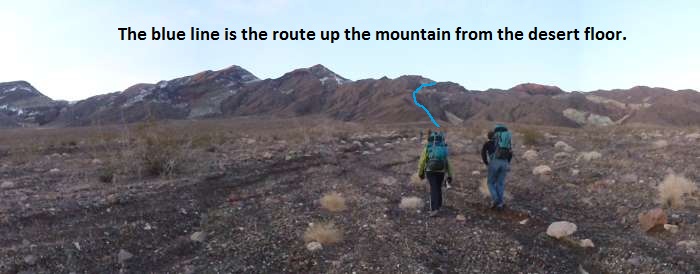
A view walking across the desert toward the ridge to start
up.
Once at the base of the ridge (wBrimNF-RP-01) start up the very
gentle slope. About 500 feet farther the ridge goes from a gentle
slope to a steeper grade (wBrimNF-RP-02).
About 800 feet farther
up the ridge is a short section that requires scrambling before
being able to walk along the ridge again (wBrimNF-RP-03). This is
an easy scramble and is only noted for a land mark.
About 1300
feet farther up the ridge is a highpoint along the ridge
(wBrimNF-RP-04). Just before reaching this high point there is a
section of that you will need to scramble / up climb to get up. The
up climb is relatively easy but care should be taken since the rock
is crumbly and brittle. This high point is just above a white
section of rock. The white section of rock makes a good land mark
and can be seen on the right before scrambling up to the high point.
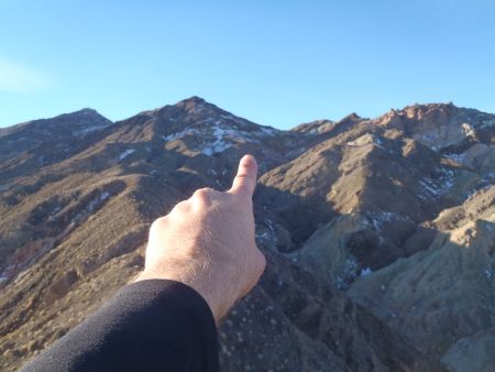
We are going to that saddle.
From this area you have a good view of the saddle you are
trying to reach. It is just right (north west) of the high pointy
peak ahead of you.
A little more than 100 feet after the high point on the ridge
will be a notch in the ridge that you need to cross. The down climb
into the notch is about 15 feet and full of more loose crumbly
rock. Not a difficult down climb but care needs to be taken here as
well. After crossing the notch travel up the ridge becomes a walk
up a slope again starting with a gentle grade and slowly getting a
little steeper.
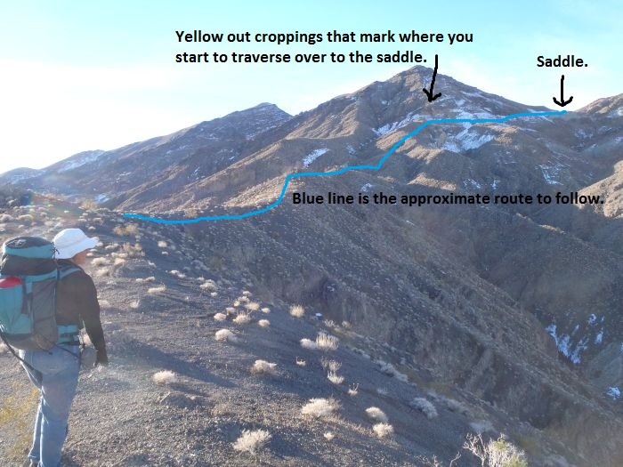
A view of the route to traverse over to the saddle.
About 0.5 miles up the ridge after
crossing the notch you will get to a the base of a section of with a
lot of yellowish out croppings on the ridge (wBrimNF-RP-05). To
continue directly up the ridge you would need to climb the yellow
out croppings. Instead veer right (west) and traverse along the
steep scree slope. Traversing this section is a bit annoying since
you are travel sideways across the mountain side in loose rock.
As you traverse here you are trying to get to the wide saddle about 0.2
miles west of the yellow out croppings. To the right of the saddle
you can see a deep notch. That notch is where you will begin the
descent down into the canyon.
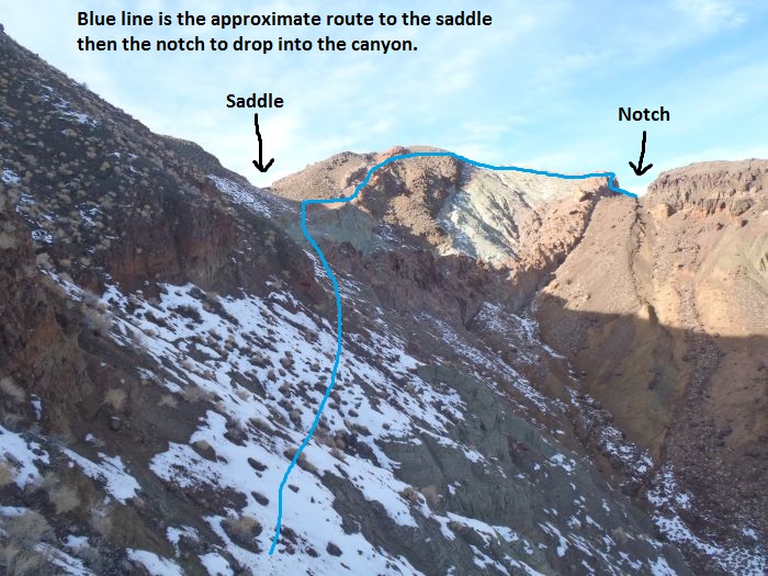
After going to the wide saddle, go up and over the peak and
down climb into the notch. Dropping down the other side of the
notch begins the descent down into the North Fork of Brimstone.
About 0.2 miles of the traverse gets
you to a saddle (wBrimNF-RP-06). This saddle has great views down
into parts of Brimstone and back toward the Dante’s View road.
From the saddle (wBrimNF-RP-06) walk up the slope to the west about
400 feet to the top of a peak (wBrimNF-RP-07). This peak is the
high point on the route. More good views with a good look down into
parts of the complex area of the North Fork of Brimstone.
From the
peak that was the high point of the route, continue over the other
side of the peak. As you continue west over the peak start veering
to the right (north) to get over to the deep notch you could see
from the saddle. The notch is about 375 feet from the peak.
When
you get to the notch route find your way down into the notch. You
will need to do some scrambling down rock to get down the short
drop. Down in the notch is where the head of the canyon is marked
(yBlkSmthNF2-Tp).
The Canyoneering / Technical Section:
From the notch marking the head of the canyon (yBlkSmthNF2-Tp),
travel down the slope on the north west side of the notch.
As you drop down the slope from the notch you will have two options
to go down. There are two drainages forming. Stay to the right and
descend the drainage on the right not the one on the left.
Soon you should be able to see a point sticking up between the two
drainages about 450 feet down canyon of the notch where you dropped
in. Travel down the right drainage to get down canyon of this
point.
When you get just under the point you will get to the top of a dry
fall (wBrimNF-RP-08). When you get to this dry fall, scramble up
and over to the left (south). The scramble up and over will be just
below the point used as a land mark when dropping from the notch.
Drop down to the drainage on the other side of the point where you
will find rap 1.
This upper section of the canyon is full of loose chossy crumbly
rock. The rock quality does improve a little ways down canyon and
travel becomes a lot more fun.
Rap 1 (dBrimNF2-R1-2) is about 600 feet down canyon of the drop in
from the notch. Rap 1 is anchored form a large boulder and drops
about 55 feet down a sloped section of loose rock.
Rap 2 is about 40 feet down canyon of rap 1. Rap 2 is anchored from
a boulder about 23 feet back from the top of the drop and drops
about 30 feet. The first part is sloped then goes vertical.
Shortly down canyon of rap 2 is a down climb of about 15 or 20
feet. The down climb is down a chute with lots of loose crumbly
rock. The down climb is not difficult but the rock quality demands
attention.
Shortly down canyon is another down climb of about 30 feet. The
bottom 6 or 8 feet of this down climb has an overhang and will be a
bit challenging.
Continuing down canyon the route is steep and full of loose rock and
debris with a few light scrambles.
Rap 3 (dBrimNF2-R3-4) is about 350 feet down canyon of rap 2. Rap 3
is anchored from a cairn anchor about 10 feet back from the drop.
Rap 2 drops down a sloped wall with a ledge about half way down.
Rap 2 is about 95 feet from anchor to ground at the bottom. Again
more loose rock.
Rap 4 is a short distance down canyon of rap 3 in a narrow section
and is anchored from a cairn anchor about 30 feet back from the
drop. Rap 4 drops about 35 feet down a vertical wall with a little
bit of free hang at the bottom. It is about 65 feet from anchor to
the ground at the bottom of the rap.
Down canyon of rap 4 the canyon has a narrow feel and provides a
three down climbs ranging from 6 to feet.
Rap 5 (dBrimNF2R-5-6) is about 300 feet down canyon of rap 4 and is
anchored from a large rock laying in the wash about 15 feet back
from the top of the drop. Rap 5 drops about 20 feet giving a total
rope travel from anchor to ground of about 35 feet.
Just after rap 5 is a down climb of about 15 feet. The better down
climber of the group should provide a meat anchor for everyone at
this drop then down climb last. The down climb will be challenging
due to loose rock. Rap 6 is near the bottom of the down climb.
Rap 6 is anchored from a cairn anchor about 8 feet back from the top
of the drop. About the first 50 feet of rap 6 is just and easy
scramble down climb. Then there is a vertical drop of about 20
feet. Total rope travel is about 70 feet for a vertical drop of
about 20 feet.
Down canyon of rap 6 the grade gets gentler and the canyon opens up
a bit. Travel starts to get a little easier with a mix of wash
walking and multiple easy down climb scrambles.
About 0.3 miles down canyon of rap 6 is a drop of about 25 feet
(wBrimNF-RP-09). This drop is bypassed by climbing up and over LDC
then sliding down a scree slope back to the canyon floor.
Rap 7 (dBrimNF2-R7) is about 150 feet down canyon of the drop that
was bypassed by the scree pile with a drop of about 5 feet before
getting down to it. Rap 7 is anchored from a rock jug about 15 feet
back from the drop then drops about 40 feet down a mostly sloped
wall. Rap 7 is likely down climbable.
Down canyon of rap 7 the canyon rock starts to take on a concrete
like feel. The rock starts to become more conglomerate like and
feels like you are navigating a big messy pour of concrete.
Rap 8 (dBrimNF2-R8) is about 450 feet down canyon of rap 7 and is
anchored from rocks in a rock fall debris area about 50 feet back
from the drop. Rap 8 drops about 40 feet down a sloped wall with
parts of it feeling almost down climb like. The total rope travel
needed from anchor to the ground at the bottom of the rappel is
about 90 feet.
After rap 8 is a drop of about 25 to 30 feet down some boulders.
Rap 9 (dBrimNF2-R9) is about 150 feet down canyon of rap 8 and is
anchored from rock embedded in the wash along with lots of other
rock debris. Rap 9 looks big from the top and has a view of a long
section of wash below it to walk after. Rap 9 drops 95 feet down a
vertical wall. It feels like you might get some free hang along the
way but your feet are able to touch the wall all the way down.
Down canyon of rap 9 is easy wash walking with a few easy down
climbs. One area has a lot of small flat rocks stacked to make up
the RDC wall of the canyon. This section is very pretty and catches
your eye. Shortly after is where another drainage joins in from RDC
(wBrimNF-RP-10). Where the drainage joins in is about 500 feet down
canyon of rap 9.
About 300 feet down canyon after the drainage joining in is rap 10.
Rap 10 (dBrimNF2-R10) is anchored from a medium size bush about 25
feet back from the top of the drop. Rap 10 drops over the edge of a
wide rim pour off in the wash about 80 feet down a vertical wall.
The total rope travel needed will be 100 feet with 80 feet of it
being the rappel and 20 feet back to the anchor.
Down canyon of rap 10 is a section with a lot of boulder and rock
debris to scramble over and through, nothing difficult.
Rap 11 (dBrimNF2-R11) is anchored from one of many rocks in the
boulder debris. Rap 11 drops about 75 feet starting over boulders
then down an almost vertical wall.
After rap 11 is a big rock fall to scramble down in a semi steep
section. Just after the rock fall debris area the wash levels out
and gives way to easy wash walking and the occasional easy scramble.
About 0.2 miles down canyon of rap 11 another drainage joins in from
LDC (wBrimNF-RP-11). Continuing down canyon is still easy wash
walking. The canyon has gotten a lot more casual and scenic along
this area.
Rap 12 (dBrimNF2-R12) is about 0.2 miles down canyon of the
confluence with the last drainage. Rap 12 is anchored from a large
rock in the wash. The first 30 feet of the drop from the anchor is
down climbable then another 30 feet of vertical wall. Rap 12 drops
alongside and partially under a huge boulder in the wash.
Rap 12 can be bypassed by climbing up and around LDC. Down climb in
a chute then scurry down a rock slope.
Rap 13 (dBrimNF2-R13) is a little over 200 feet down canyon of rap
12. Rap 13 is anchored about 20 feet back from the drop from a
cairn anchor. Rap 13 drops over two stages about 95 on the LDC side
of the canyon. Rap 13 looks like a creative down climber could get
down this rap.
Rap 14 (dBrimNF2-R14) is about 100 feet down canyon of rap 13. Rap
14 is anchored LDC from a boulder in the wash. The shape of this
rock looks like the webbing could slip off if pulled the wrong way
so the anchor is redirected through a small hole under other
boulders near the top of the drop. Rap 14 drops about 75 feet with
the top part almost gently sloped enough to down climb.
Down canyon of rap 14 is easy wash walking with some pretty corridor
sections. This lower part of the canyon is very scenic. The
variety of colors in the walls along the corridors is interesting.
There are a couple easy down climbs along the way but most is just
peaceful feeling wash walking. 0.3 miles down canyon of rap 14
another drainage joins in from RDC (wBrimNF-RP-12).
About 0.3 miles down canyon of the last drainage joining in is a
drop of about 15 feet (wBrimNF-RP-13). This drop is a moderately
challenging chimney style down climb. Weaker down climbers may want
a meat anchor here.
Note:
If you decide to hike up from the bottom to see this area you will
need to up climb this to continue up canyon. Doing so will reward
you with a long beautiful section to walk.
A few hundred feet down canyon of the junction with the south fork
is a small pile of boulders in the wash with space large enough for
you to walk under as you continue down canyon. There are a couple
minor down climbs a little further down canyon.
About 0.4 miles down canyon of the fork the canyon walls get lower
and the canyon comes to an end (yBRimStoneBt). The grooves in the
alluvial fan are pretty deep here and it still feels like you are
still IN the canyon.
The Exit:
After exiting Brimstone canyon, walk about 2.4 miles southwest
across the alluvial fan to Bad Water Road were you left your exit
vehicle parked at the turn off for the Devil’s Golf Course (extDevilsGolf).
Another 0.2 miles down canyon is the confluence of the South and
North Forks of Brimstone Canyon.
Downloadable GPX files
available at
BG-Gear Store
(easier than manual entry and a great way to support
Bluugnome).
Waypoint naming convention and map symbol information can be found on the Glossary page.
Elevations are approximate.
BEFORE
manually entering coordinates set your system to WGS84 datum and Lat/Lon hddd.ddddd° coordinate format.
Inconsistent datum's and coordinate formats will result in location errors.
Click to show / expand the list of waypoints below........
| BrimstoneNF 1 - Drive to lower exit |
- extBadWatr-190
Lat/Lon (WGS84): N 36.44835
W -116.85247
Elev: 10 Feet
Junction of highway 190 and Badwater Road (178).
- extDesoltnCyn
Lat/Lon (WGS84): N 36.39642
W -116.84753
Elev: -186 Feet
Exit for the road to Desolation Canyon.
- extDevilsGolf
Lat/Lon (WGS84): N 36.29845
W -116.81171
Elev: -200 Feet
Turn off for the Devil's Golf Course. Park here to leave an exit vehicle when doing Brimstone Canyon.
|
| BrimstoneNF 2 - Drive to Trailhead |
- extBadWatr-190
Lat/Lon (WGS84): N 36.44835
W -116.85247
Elev: 10 Feet
Junction of highway 190 and Badwater Road (178).
- ext-20Mule-In
Lat/Lon (WGS84): N 36.40941
W -116.79466
Elev: 840 Feet
Entrance to the 20 Mule Team Rd.
- extHoleInWall
Lat/Lon (WGS84): N 36.40480
W -116.78271
Elev: 1,039 Feet
Exit for the Hole in the Wall road.
- ext-20Mule-Out
Lat/Lon (WGS84): N 36.39784
W -116.77033
Elev: 1,148 Feet
Exit to the 20 Mule Team Rd.
- pBrimstoneNFtp
Lat/Lon (WGS84): N 36.36529
W -116.72385
Elev: 1,806 Feet
Parking spot along side the road to start the Bimstone Canyon North Fork. No specific parking spot. Just pull off where it feel comfortable.
|
| BrimstoneNF 3 - Approach |
- pBrimstoneNFtp
Lat/Lon (WGS84): N 36.36529
W -116.72385
Elev: 1,806 Feet
Parking spot along side the road to start the Bimstone Canyon North Fork. No specific parking spot. Just pull off where it feel comfortable.
- wBrimNF-RP-01
Lat/Lon (WGS84): N 36.35006
W -116.73741
Elev: 2,520 Feet
Bottom of the ridge to start climbing up the mountain from the desert floor.
- wBrimNF-RP-02
Lat/Lon (WGS84): N 36.34931
W -116.73915
Elev: 2,585 Feet
The ridge goes from a gentle slope to a steeper grade.
- wBrimNF-RP-03
Lat/Lon (WGS84): N 36.34758
W -116.74053
Elev: NaN Feet
Short section to scramble up the ridge before being able to walk again.
- wBrimNF-RP-04
Lat/Lon (WGS84): N 36.34526
W -116.74359
Elev: 3,250 Feet
A high point along the ridge. Just before reaching this is a section to scramble / up climb in loose crumbly rock. About 150 feet after this is a notch in the ridge to cross with a 15 foot down climb in more loose crumbly rock.
- wBrimNF-RP-05
Lat/Lon (WGS84): N 36.33847
W -116.74641
Elev: 3,840 Feet
At the base of some yellow out croppings. Ratehr than climb up the out croppings, traverse right along the side of the mountain and get over to the wide saddle about 0.2 miles west.
- wBrimNF-RP-06
Lat/Lon (WGS84): N 36.33720
W -116.74951
Elev: 3,985 Feet
Saddle with great views down into parts of Brimstone and back ovder the Dante's View road area. The notch to the north is where you will drop into the North Fork of Brimstone. That is the middle of three possible forks of the middle fork.
- wBrimNF-RP-07
Lat/Lon (WGS84): N 36.33743
W -116.75074
Elev: 4,025 Feet
Peak between the saddle and the notch where you will drop into the North Fork of Brimstone.
- yBlkSmthNF2-Tp
Lat/Lon (WGS84): N 36.33818
W -116.75059
Elev: 3,955 Feet
Top entry to The North Fork 2 of Brimstone Canyon (the center of three forks for Brimstone Canyon). This is at a deep notch in the rim above the canyon.
|
| BrimstoneNF 4 - The Canyon and Exit |
- yBlkSmthNF2-Tp
Lat/Lon (WGS84): N 36.33818
W -116.75059
Elev: 3,955 Feet
Top entry to The North Fork 2 of Brimstone Canyon (the center of three forks for Brimstone Canyon). This is at a deep notch in the rim above the canyon.
- wBrimNF-RP-08
Lat/Lon (WGS84): N 36.33865
W -116.75235
Elev: NaN Feet
Top of a dray fall. When you get here cut up and over to the left (south). Scramble up and over just below a prominent point then drop back down to teh drainage on the other side.
- dBrimNF2-R1-2
Lat/Lon (WGS84): N 36.33845
W -116.75236
Elev: 3,600 Feet
Raps 1 and 2 - North Fork 2 of Brimstone Canyon.
Rap 1 anchored from a boulder and drops about 50 feet.
Rap 2 is about 40 feet down canyon of rap 1, is anchored from a boulder about 25 feet back from the drop and drops about 30 feet.
- dBrimNF2-R3-4
Lat/Lon (WGS84): N 36.33831
W -116.75352
Elev: NaN Feet
Raps 3 and 4 - North Fork 2 of Brimstone Canyon.
Rap 3 is anchored from a cairn anchor about 10 feet back and drops about 95 feet from anchor to ground on a sloped wall with a ledge half way down.
Rap 4 is anchored from a cairn anchor about 30 feet back from the top of the drop and drops about 35 feet
- dBrimNF2-R5-6
Lat/Lon (WGS84): N 36.33818
W -116.75473
Elev: NaN Feet
Raps 5 and 6 - North Fork 2 of Brimstone Canyon.
Rap 5 is anchored from a rock about 15 feet back from the drop then drops about 20 feet.
There is a down climb of about 15 feet between raps 5 and 6 that should have a meat anchor given.
Rap 6 is anchored from a cairn anchor about 8 feet back. The first 50 feet of rap 6 is an easy scramble down climb. The last 20 feet is a vertical drop.
- wBrimNF-RP-09
Lat/Lon (WGS84): N 36.33756
W -116.75911
Elev: 2,660 Feet
Drop of about 25 feet that would not be a good idea to down climb. Bypass by climbing up and around LDC then slide down a scree slope back to the canyon floor.
- dBrimNF2-R7
Lat/Lon (WGS84): N 36.33735
W -116.75961
Elev: NaN Feet
Rap 7 - North Fork 2 of Brimstone Canyon. Anchored from a rock jug about 15 feet back then drops about 40 feet down a sloped wall. Rap 7 is likey down climbable.
- dBrimNF2-R8
Lat/Lon (WGS84): N 36.33675
W -116.76085
Elev: 2,436 Feet
Rap 8 - North Fork 2 of Brimstone Canyon. Anchored from rocks in a rock fall debris area. Anchor is set back about 50 feet then there is a drop of about 40 feet down a sloped wall. Total rope travel is about 90 feet.
- dBrimNF2-R9
Lat/Lon (WGS84): N 36.33689
W -116.76133
Elev: NaN Feet
Rap 9 - North Fork 2 of Brimstone Canyon. Anchored from a wash embbeded in the wash among other rock debris and drops 95 feet down a vertical wall.
- wBrimNF-RP-10
Lat/Lon (WGS84): N 36.33628
W -116.76254
Elev: NaN Feet
Another drainage joins in from RDC.
- dBrimNF2-R10
Lat/Lon (WGS84): N 36.33550
W -116.76286
Elev: NaN Feet
Rap 10 - North Fork 2 of Brimstone Canyon. Anchored about 25 feet back from a medium size bush then drops about 80 feet down a vertical wall. Total rope travel needed is 100 feet.
- dBrimNF2-R11
Lat/Lon (WGS84): N 36.33496
W -116.76284
Elev: NaN Feet
Rap 11 - North Fork 2 of Brimstone Canyon. Anchored from one of many rocks in the boulder debris and drops about 75 feet. THe rap starts over some boulders then down an almost vertical wall.
- wBrimNF-RP-11
Lat/Lon (WGS84): N 36.33190
W -116.76254
Elev: 1,697 Feet
Confluence joins in from LDC.
- dBrimNF2-R12
Lat/Lon (WGS84): N 36.33061
W -116.76470
Elev: 1,590 Feet
Rap 12 - North Fork 2 of Brimstone Canyon. Anchored from a rock at the top of trhe drop and drops about 60 feet with teh first 30 being an easy down climb. RAp 12 can be bypassed by climbing up and around LDC.
- dBrimNF2-R13
Lat/Lon (WGS84): N 36.33005
W -116.76504
Elev: NaN Feet
Rap 13 - North Fork 2 of Brimstone Canyon. Anchored from a cairn anchor and drops about 95 feet down two stages on the LDC side of the canyon.
- dBrimNF2-R14
Lat/Lon (WGS84): N 36.32980
W -116.76522
Elev: NaN Feet
Rap 14 - North Fork 2 of Brimstone Canyon. Anchored LDC from a boulder and redirected through a hole under a large boulder. Drops about 75 feet with the first part gently sloped.
- wBrimNF-RP-12
Lat/Lon (WGS84): N 36.32726
W -116.76962
Elev: 1,225 Feet
Drainage joins in from RDC.
- wBrimNF-RP-13
Lat/Lon (WGS84): N 36.32439
W -116.77326
Elev: NaN Feet
Drop of about 15 feet. This down climb is a moderately difficult chimney down climb.
- jbrimMain
Lat/Lon (WGS84): N 36.32196
W -116.77536
Elev: 800 Feet
Junction where the North and South forks of Brimstone Canyon meet.
- yBrimStoneBt
Lat/Lon (WGS84): N 36.31876
W -116.78101
Elev: 580 Feet
Bottom exit of Brimstone Canyon.
- extDevilsGolf
Lat/Lon (WGS84): N 36.29845
W -116.81171
Elev: -200 Feet
Turn off for the Devil's Golf Course. Park here to leave an exit vehicle when doing Brimstone Canyon.
|