Canyoneering Route Description
Arachnophobia Canyon - 3A II
Death Valley National Park,
California.
02-29-20, 9 people, 1 Day (Travel time in route 7.5 hours)
 Time includes 1hr 10min break on approach hike.
Time Required - 5 to 6.5 hours
Distance - 4.0 miles Total, 4.7 miles Technical
Rappels - 10 Rappels, Longest Rappel 170 feet.
Elevation Range - 1850 to -50 Feet
Shuttle Required - Yes 10.9 Miles Vehicle -
Passenger
Permit Required - No
Rappelling and anchor gear. Ropes and pull cords for rappels up
to 170 feet and 80 feet of 1 inch webbing for sling placement.
ATTENTION!!
Death Valley is considering a new permit system in response to the impact of the growing popularity of Canyoneering.
Lets continue to show the park just how respectful we can be to our environment.
Specific issues the park is concerned about:
1. Anchors: Bolting is Illegal in Death Valley National Park! Do Not Add Bolts. Natural anchor options are abundant.
Recent illegal bolts have popped up in Helios and Rainbow Canyons.
2. Poop: Dig a cathole at least 6 inches deep and 200 yards from any water source or campsite. Pack out all toilet paper.
3. Collecting fire wood is illegal, just don't do it!
Other basics:
Avoid walking in water when possible (Willow Canyon, etc).
Hike on durable surfaces and previously worn paths (avoid trampling vegetation or fragile soil crusts).
Pack out all trash including organic material (including seed shells, apple cores, orange peels, etc).
More info can be found here: http://www.nps.gov/deva/planyourvisit/backcamp.htm
Lets keep this wonderful resource pristine so that we may continue to enjoy the canyons with limited regulations!
Arachnophobia is fun half day canyon in the same area as
Scorpion and Vinegaroon Canyons and sharing the same colorful scenery.
Arachnophobia requires a car shuttle. The number of rappels you encounter may
vary as there have been cairns built at the top of downclimbs and there a lot of
different ways you can combine raps and downclimbs.
Arachnophobia uses the same approach hike as Scorpion
Canyon. As you drop into the large upper wash of Scorpion Canyon, there are
multiple places you can leave Scorpion and hike up slopes to get to
Arachnophobia. Thanks to Abby for trying a few of the options and letting me
know the one described here is by far the easiest way between Scorpion and
Arachnophobia.
To get to the Trailhead
From the Junction of highway 190 and highway 178, drive south
east on highway 190 for 4.7 miles to the turn off for the Twenty
Mule Team road (ext-20Mule-In) on the right (south) side of the
highway. The Twenty Mule Team road is a dirt road that
runs for about 2.6 miles and comes back out to the highway a
little south of where you entered. Turn right (south) onto
the Twenty Mule Team road and drive 1.7 miles to a parking
turnout on the right (pkScorpion). This turnout is
just as you reach a sharp left hand bend in the road. Park
the entry vehicle here. Remember to go set an exit vehicle
as this route requires a shuttle.
To leave the Exit Vehicle / Escape Pod
From the Junction of highway 190 and highway 178 (Badwater
Road), drive south on highway 178 for 3.7 miles to a dirt road
(extDesoltnCyn) on the left (east). Turn left onto the
Desolation Canyon road and drive 0.5 miles east to the end of
the dirt road where there is a large parking area (tDesolationCyn).
Park the exit vehicle here.
GPS coordinate information listed at the bottom. For information about waypoint naming and map symbols, refer to the
Glossary page.

Click the links for maps of the route.
Map of the entire route.
Map of the first part of approach.
Map of the first second part of approach.
Map of the technical section.
Map of the exit.
The Approach:
From the parking spot (pkScorpion)
walk about 350 feet
north on the Twenty Mule
Team road to a large
wash (wScorpionRP01)
leaving the road and
traveling southwest.
Turn left and walk
southwest up the large
wide wash. About
700 feet from the road
the wash is wide and may
seem to have forks
coming in. Just
keep following straight
up southwest of what
feels like the main
wash.
About 0.28 miles up the
wash you may notice a
doorway shaped hole
(wScorpionRP02) in the
hillside on the left
(southeast) side.
There are a couple short
tunnels here. As a
general rule it is best
to do as the park
says.... Stay Out - Stay
Alive.
Another 650 feet
southwest up the
drainage is where the
wash begins to get a
little more narrow
(wScorpionRP03).
About 400 feet farther
the wash makes a left -
right jog
(wScorpionRP04) shortly
before getting to a more
wide open section of the
wash.
About 350 to 400 feet
farther will be a spot
to scramble up about 15
feet. Just after
the scramble up will be
a confluence of 3 forks
(wScorpionRP05).
From the confluence
travel southwest up the
left most fork.
Travel from here gets
steeper but is mostly an
easy walk up with an
occasional spot where
you might want to use
your hands for balance.
About 500 feet farther
is a narrow spot where
you need to scramble
about 15 feet up a steep
section (wScorpionRP06)
that also has a lot of
loose sand and gravel on
it.
Continue light
scrambling up a
moderately steep section
for about 200 feet until
you get to a more wide
open area
(wScorpionRP07) and easy
wash walking again.
There is a confluence
here of a few forks.
Travel up the left most
fork going southeast
then shortly after
turning right to travel
southwest again.
Note:
From this confluence you
can see a white
conglomerate cliff band
ahead to the west.
What you will be trying
to do from here is
travel up to the left
(south) side of the
cliff band.
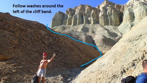 Follow the washes around the left side of the white conglomerate cliff band.
After turning up the
leftmost fork
(wScorpionRP07) it will
veer right and begin
traveling southwest
again for about 200 feet
to a short easy scramble
up (wScorpionRP08).
After you get up the
scramble you should be
able to see an obvious
saddle about 350 feet
ahead to the southwest.
Note the water runnel
traveling down from the
saddle to the wash you
are in. Walk the
wash over to the runnel
then scramble your way
up the water runnel to
get up onto the saddle
(wScorpionRP09).
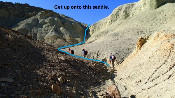 Follow the wash and the water runnel up onto this saddle.
From the saddle follow
down the water course on
the other side running
down to the west.
After about 300 feet you
will drop into a VERY
wide wash
(wScorpionRP10) which is
the Scorpion Canyon
drainage running down to
the northwest.
At this point the wash
is very wide and flat
providing easy walking
for long way.
About 0.8 miles down the
wash is another large
wash (jVinegaroon)
joining in from the
right (north).
Note:
Stay in the main wash
and travel down to the
west to continue on the
Scorpion Canyon route.
If you were going to
Vinegaroon Canyon you
would turn right and
travel north up this
wide side wash.
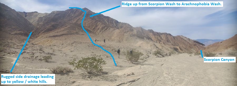
About
400 feet farther down
the wash is where you
leave (jArachno) the
Scorpion wash to go up
toward Arachnophobia.
Note a rugged side
drainage on the LDC
(south) side leading up
toward yellow/white
slopes. Leave the
Scorpion wash and hike
up the ridge on the
right (west) side of the
side wash. The ridge is
steep but easy to
navigate and walk up
with a few outcroppings
to go around.
Note:
The ridge is about 400
feet after passing the Vinegaroon
wash. The rugged side
drainage just before the
ridge is identified by
seeing that the drainage
leads up to yellow/white
slopes.
About 500 feet up the
ridge is a rock
outcropping (Arachno02)
on the ridge. Go around
the left side and
continue up the ridge.
There will be a couple
more minor outcroppings
to go around on the way
up the ridge.
About 375 feet farther
the ridge tops out
(Arachno3). Walk down
slope into the wash
below then turn right
and walk west down the
Arachnophobia wash.
About 1000 feet farther
is the head of
(Arachno4) a deep
drainage with a 20 foot
drop and leading north
down to Scorpion Canyon.
Continue west down the
gentle slope of
Arachnophobia. Don't
accidentally drop down
toward Scorpion.
About 0.4 miles farther
is top of Arachnophobia
Canyon (yArachnoTp)
where wide open spacious
views over the Death
Valley flats as you
approach the steeply
dropping technical
section ahead.
The Canyoneering / Technical Section:
From top of the
canyon (yArachnoTp) walk
over to the first rap.
Rap 1 (dArachR01)
anchored from cairn
anchor and drops about
100 feet over multiple
stages and rugged
ledges. At the bottom of
rap 1 is a downclimb of
about 12 feet to the top
of rap 2. Optionally you
can use a longer rope
and rap past the
downclimb directly to
rap 2.
Rap 2 (dArachnoR02)
anchored from an
equalized pinch point
and redirected knot
chock and drops about 35
feet. Just after the rap
is a cairn anchor we did
not use at the top of a
downclimb of about 12
feet down to rap 3.
Optionally you could use
longer rope for rap 2
and combine it with the
downclimb.
Rap 3 (dArachnoR03)
anchored from a cairn
anchor and drops about
170 feet down a vertical
wall with a lot of free
hang. Be careful of
sharp rock that can cut
rope. Reset the rope a
foot or so after between
people.
The next 450 feet is a
mix of wash walking and
a few minor scrambles.
Rap 4 (dArachnoR04)
anchored from a cairn
anchor and drops about
60 feet. Just before
getting to the rap is a
steep easy downclimb of
about 30 feet over 2
stages.
The next 1000 feet of
canyon is a mix of
walking and a few short
easy scrambles.
Rap 5 (dArachnoR05)
anchored from a pinch
point at the top of the
drop and drops about 80
feet. The anchor here
used to be an equalized
knot chock and rock horn
up on the RDC side.
Rap 6 (dArachnoR06)
anchored from a large
rock about 20 feet back
and drops about 20 feet
and is awkwardly
overhung.
About 250 feet farther
is a downclimb of about
6 feet followed by easy
walking for about 130
feet to the next rap.
Rap 7 (dArachnoR07)
anchored from a cairn
anchor about 10 feet
back and drops about 25
feet.
About 30 feet
down canyon is a sloped
downclimb along the LDC
side down to the next
rap.
Rap 8 (dArachnoR08)
anchored from a cairn
anchor about 25 feet
back and drops about 45
feet down a vertical
trough like feature.
Just after is a sharp
right hand bend in the
canyon before reaching
the final 2 rappels.
Rap 9 (dArachnoR09)
anchored from a cairn
anchor about 25 feet
back uses about 50 feet
of rope as the rappel
starts down a gentle
slope leading to a
vertical drop of about
20 feet. The next rappel
is right at the bottom
of this rap.
Rap 10 (dArachnoR10)
anchored from a cairn
about 20 feet back and
drops about 40 feet.
About 180 feet farther
is 2 downclimbs
(Arachno06) one right
after the other in
narrow canyon next to
large rocks of about 12
to 15 feet each.
About 650 feet farther
is the bottom of
Arachnophobia Canyon (yArachnoBt)
at a junction where
another drainage joins
in from the left.
The Exit:
From the
bottom of Arachnophobia
Canyon (yArachnoBt),
continue down canyon
following developing use
trails.
About 350 feet farther
is an easy downclimb of
about 6 feet.
Continue down canyon as
it slowly opens to wide
wash for a little over 1
mile back to the parking
spot of the exit vehicle
in Desolation Canyon
(tDesolationCyn).
Downloadable GPX files
available at
BG-Gear Store
(easier than manual entry and a great way to support
Bluugnome).
Waypoint naming convention and map symbol information can be found on the Glossary page.
Elevations are approximate.
BEFORE
manually entering coordinates set your system to WGS84 datum and Lat/Lon hddd.ddddd° coordinate format.
Inconsistent datum's and coordinate formats will result in location errors.
Click to show / expand the list of waypoints below........
| Arachnophobia (1) - Drive for exit vehicle parking and trailhead |
- extDesoltnCyn
Lat/Lon (WGS84): N 36.39660
W -116.84746
Elev: -205 Feet
Exit for the road to Desolation Canyon Trailhead.
- tDesolationCyn
Lat/Lon (WGS84): N 36.39565
W -116.83858
Elev: -50 Feet
Parking area at the end of the Desolation Canyon road. Also parking for the exit vehicle for the Scorpion Canyon and Vinegaroon Canyon Routes.
- ext-20Mule-In
Lat/Lon (WGS84): N 36.40941
W -116.79466
Elev: 840 Feet
Entrance to the 20 Mule Team Rd.
- pkScorpion
Lat/Lon (WGS84): N 36.39146
W -116.77847
Elev: 1,205 Feet
Parking spot to side of road in 20 Mule Team Road. 1 - 2 vehicles. This is the spot to park for the start of Scorpion Canyon or Vinegaroon Canyon.
|
| Arachnophobia (2) - Approach |
- pkScorpion
Lat/Lon (WGS84): N 36.39146
W -116.77847
Elev: 1,205 Feet
Parking spot to side of road in 20 Mule Team Road. 1 - 2 vehicles. This is the spot to park for the start of Scorpion Canyon or Vinegaroon Canyon.
- wScorpionRP01
Lat/Lon (WGS84): N 36.39231
W -116.77876
Elev: 1,195 Feet
To go up to Scorpion Canyon leave the Twenty Mule Team road here and start up the wash going southwest.
- wScorpionRP02
Lat/Lon (WGS84): N 36.38916
W -116.78129
Elev: NaN Feet
Small doorway shapped hole on the hillside. There is a tunnel here going through the hill to the otherside with a T part way in to a deadend tunnel part way into the hill.
- wScorpionRP03
Lat/Lon (WGS84): N 36.38779
W -116.78265
Elev: 1,360 Feet
The wash begins to get a little more narrow here.
- wScorpionRP04
Lat/Lon (WGS84): N 36.38702
W -116.78346
Elev: NaN Feet
Wash does a left - right jog here shortly before reaching a more wide open section of the wash.
- wScorpionRP05
Lat/Lon (WGS84): N 36.38700
W -116.78518
Elev: 1,450 Feet
Confluence of 3 forks. Follow the left most fork running up to the southwest.
- wScorpionRP06
Lat/Lon (WGS84): N 36.38624
W -116.78669
Elev: 1,660 Feet
A narrow spot to scramble up about 15 feet that is a little difficult since it is steep and has a lot of loose sand and gravel.
- wScorpionRP07
Lat/Lon (WGS84): N 36.38598
W -116.78724
Elev: NaN Feet
Top of a moderately steep section of scrambling and where the wash widens out again with easy wash walking. There is a confluence here of a few forks. Travel up the left most fork going southeast then shortly after turning right to travel southwest again.
- wScorpionRP08
Lat/Lon (WGS84): N 36.38552
W -116.78724
Elev: NaN Feet
Short easy scramble up in the wash. From here you can see an obvious saddle to the southwest about 350 feet away. Note the water runnel traveling up to the saddle. Continue up the wash then up the runnel to get up onto the saddle.
- wScorpionRP09
Lat/Lon (WGS84): N 36.38500
W -116.78812
Elev: 1,845 Feet
On top of a saddle after scrambling up a water runnel out of the wash. To drop into the Scorpion Drainage follow the water course running down the west side of the saddle for about 300 feet.
- wScorpionRP10
Lat/Lon (WGS84): N 36.38475
W -116.78913
Elev: 1,785 Feet
Route drops into the main water course for Scorpion Canyon.
- jVinegaroon
Lat/Lon (WGS84): N 36.38937
W -116.80203
Elev: 1,565 Feet
Large wash joining in from the right (north). Continue west down the wash to continue to Scorpion. Or Travel north up the side wash to follow the route to Vinegaroon Canyon.
- jArachno
Lat/Lon (WGS84): N 36.38928
W -116.80351
Elev: 1,550 Feet
To go to Arachnophobia, note a rugged side drainage on the LDC (south) side leading up toward yellow/white slopes. Leave the Scorpion wash and hike up the ridge on the right (west) side of the side wash. The ridge is steep but easy to navigate and walk up with a few outcroppings to go around.
Note:
The ridge is about 400 feet after passing the Vinegaroon wash. The rugged side drainage just before the ridge is identified by seeing that the drainage leads up to yellow/white slopes.
- Arachno02
Lat/Lon (WGS84): N 36.38847
W -116.80493
Elev: NaN Feet
Rock outcropping on the ridge. Go around the left side and continue up the ridge. There will be a couple more minor outcroppings to go around on the way up the ridge.
- Arachno3
Lat/Lon (WGS84): N 36.38788
W -116.80594
Elev: 1,850 Feet
The ridge tops out. Walk down slope into the wash below then turn right and walk west down the Arachnophobia wash.
- Arachno4
Lat/Lon (WGS84): N 36.38884
W -116.80900
Elev: NaN Feet
Head of a deep drainage with a 20 foot drop and leading north down to Scorpion Canyon. Continue west down the gentle slope of Arachnophobia. Don't accidentally drop down toward Scorpion.
- yArachnoTp
Lat/Lon (WGS84): N 36.38960
W -116.81514
Elev: 1,540 Feet
Top of Arachnophobia Canyon. Wide open spacious views over the Death Valley flats as you approach the steeply dropping technical section ahead.
|
| Arachnophobia (3) - The Canyon and Exit |
- yArachnoTp
Lat/Lon (WGS84): N 36.38960
W -116.81514
Elev: 1,540 Feet
Top of Arachnophobia Canyon. Wide open spacious views over the Death Valley flats as you approach the steeply dropping technical section ahead.
- dArachR01
Lat/Lon (WGS84): N 36.38955
W -116.81528
Elev: NaN Feet
Rap 1 - Arachnophobia. Anchored from cairn anchor and drops about 100 feet over multiple stages and rugged ledges. At the bottom of rap 1 is a downclimb of about 12 feet to the top of rap 2. Optionally you can use a longer rope and rap past the downclimb directly to rap 2.
- dArachnoR02
Lat/Lon (WGS84): N 36.38958
W -116.81559
Elev: NaN Feet
Rap 2 - Arachnophobia. Anchored from an equalized pinch point and redirected knot chock and drops about 35 feet. Just after the rap is a cairn anchor we did not use at the top of a downclimb of about 12 feet down to rap 3. Optionally you could use longer rope for rap 2 and combine it with the downclimb.
- dArachnoR03
Lat/Lon (WGS84): N 36.38960
W -116.81571
Elev: NaN Feet
Rap 3 - Arachnophobia. Anchored from a cairn anchor and drops about 170 feet down a vertical wall with a lot of free hang. Be careful of sharp rock that can cut rope. Reset the rope a foot or so after between people.
The next 450 feet is a mix of wash walking and a few minor scrambles.
- dArachnoR04
Lat/Lon (WGS84): N 36.38995
W -116.81691
Elev: NaN Feet
Rap 4 - Arachnophobia Canyon. Anchored from a cairn anchor and drops about 60 feet. Just before getting to the rap is a steep easy downclimb of about 30 feet over 2 stages.
The next 1000 feet of canyon is a mix of walking and a few short easy scrambles.
- dArachnoR05
Lat/Lon (WGS84): N 36.38991
W -116.81992
Elev: NaN Feet
Rap 5 - Arachnophobia. Anchored from a pinch point at the top of the drop and drops about 80 feet. The anchor here used to be an equalized knot chock and rock horn up on the RDC side.
- dArachnoR06
Lat/Lon (WGS84): N 36.38973
W -116.82059
Elev: NaN Feet
Rap 6 - Arachnophobia. Anchored from a large rock about 20 feet back and drops about 20 feet and is awkwardly overhung.
- Arachno05
Lat/Lon (WGS84): N 36.38930
W -116.82126
Elev: NaN Feet
Downclimb of about 6 feet followed by easy walking for about 130 feet to the next rap.
- dArachnoR07
Lat/Lon (WGS84): N 36.38908
W -116.82157
Elev: NaN Feet
Rap 7 - Arachnophobia. Anchored from a cairn anchor about 10 feet back and drops about 25 feet.
About 30 feet down canyon is a sloped downclimb along the LDC side down to the next rap.
- dArachnoR08
Lat/Lon (WGS84): N 36.38886
W -116.82163
Elev: NaN Feet
Rap 8 - Arachnophobia. Anchored from a cairn anchor about 25 feet back and drops about 45 feet down a vertical trough like feature.
Just after is a sharp right hand bend in the canyon before reaching the final 2 rappels.
- dArachnoR09
Lat/Lon (WGS84): N 36.38854
W -116.82176
Elev: NaN Feet
Rap 9 - Arachnophobia. Anchored from a cairn anchor about 25 feet back uses about 50 feet of rope as the rappel starts down a gentle slope leading to a vertical drop of about 20 feet. The next rappel is right at the bottom of this rap.
- dArachnoR10
Lat/Lon (WGS84): N 36.38855
W -116.82194
Elev: NaN Feet
Rap 10 - Arachnophobia. Anchored from a cairn about 20 feet back and drops about 40 feet.
- Arachno06
Lat/Lon (WGS84): N 36.38851
W -116.82254
Elev: NaN Feet
2 downclimbs one right after the other in narrow canyon next to large rocks of about 12 to 15 feet each.
- yArachnoBt
Lat/Lon (WGS84): N 36.38815
W -116.82443
Elev: 330 Feet
Bottom of Arachnophobia Canyon at a junction where another drainage joins in from the left.
Continue down canyon following developing use trails.
- Arachno07
Lat/Lon (WGS84): N 36.38837
W -116.82530
Elev: NaN Feet
Easy downclimb of about 6 feet.
- tDesolationCyn
Lat/Lon (WGS84): N 36.39565
W -116.83858
Elev: -50 Feet
Parking area at the end of the Desolation Canyon road. Also parking for the exit vehicle for the Scorpion Canyon and Vinegaroon Canyon Routes.
|