Canyoneering Route Description
Lost Angel Canyon - 3A III
Dirty Devil Area, Utah.
03-29-16, 2 people, 1 Day (Travel time in route 5 hours)

Time Required - 4 to 6 hours
Distance - 5.3 miles Total, 0.5 miles Technical
Rappels - 6 Rappels, Longest Rappel 180 feet.
Can be done with a shorter rope, General Comments for details.
Elevation Range - 4850 - 4150 Feet
Shuttle Required - No Vehicle - High Clearance
or carefully driven passenger car
Permit Required - No
Rappelling and anchor gear, Ropes and or pull cords for rappels up
to 180 feet and 80 feet of 1 inch webbing for sling placement.
Lost angel is a great route to visit if you have seen
the others or want a little longer day. The canyon is worthwhile but
if you are looking for more bang for your buck some of the other Angels may
be a better choice since Lost angle has a longer approach, a longer exit and
does not offer a significant increase in canyono fun or scenic value.
The recomendation for 80 feet of webbing is so spare
webbing is on hand in the event the webbing at rap 6 needs to be replaced.
50 feet of webbing will be needed for just that rappel if replacing the
webbing.
The last road you turn off onto may have some rough
spots (depending on when it was last maintained) that a passenger car may
not like. If you find it too rough to travel there is space to get a
couple cars parked off to the side of the road at the previous road
junction. From there you can walk the 0.36 miles of dirt road instead
of drive in.
There is an arch high up on the RDC wall near the end
of the canyon that can be easily missed if you are not looking carefully.
If you do miss it the arch can readily be seen in the distance while walking
the exit route.
Lost Angel Canyon does not have a lot of water holding
capacity so if there are recent rains you may expect some shin deep water in
places but not much more.
A fun note for those who enjoy playing with echo walls.
Shortly after starting on the use trails along the river bank after exiting
the canyon there is a large flat wall on the opposite side of the river.
This makes for great sonic fun!
Note:
Both upper forks leading
down to the top of Lost Angle forks drop down to roughly
the same location, each having a spot to rappel into an alcove like spot below. The
fork to the right (south) on the way in is what has been described in some other route desctiptions and
involves rappelling from a dead tree. The tree appeared solid when we
were there in March 2016, however rappelling from a dead tree is a bad idea
since it will fail at some point. The fork to the left (north) on the
way in, as followed by this
route description, gets to a drop with a lot of boulder debris at the top
which is used for an anchor instead. Both rappels are of similar
hieght and go to the same place so the left fork rap 1 is preferred for
safety resons. If you would like to look at both options it is a quick
80 feet walk up and over between the forks so you can make your own choice.
Note:
The final rap (rap 6) is
anchored from a tree and
travels about 180 feet
to base of rappel.
However the first 50
feet the rap needs to
have the anchor webbing
extended over 2 potholes
that can be downclimbed
through leaving only 130
feet of rope travel
needed for the rappel.
After the 2 potholes,
Rap 6 goes down a mostly
vertical wall with the
last 15 feet being
downclimable. The
downclimbs into each of
the potholes is about 15
feet with the second
being moderately
difficult but the anchor
webbing can be used as a
handline if needed.
After 2nd pothole rap
drops off vertical.
This is mentioned so the
actual lengths of what
are needed are known
before you go in. If
you go in with a lot of
webbing and can extend
the anchor as needed
then a rope shorter than
180 can be used.
However if you do not
extend the webbing over
the potholes you will
need more rope, have a
more difficult rope pull
and leave more rope
grooves on the canyon
walls. Bring webbing,
please extend the
anchor.
Note:
There are a
couple rock art panels
to check out on the
exit. See the
route description for
details on finding them.
To get to the Trailhead
From the junction of highway 95 and highway 24 in Hanksville
Utah, drive 10.2 miles south on highway 95 to an un-named dirt
road on the left (extAngelTrlRd). The road has a BLM sign
saying it goes out to the Angel Trail. Turn left (east) on the
Angel Trail road and ignore smaller dirt roads that branch off.
2.4 miles from the highway will be a Y in the road (ex0100-0101DD).
Turn left at this Y and continue toward the Angel Canyons on the
road labeled 0100.
Stay on road 0100 for
5.9 miles to a turn off to another road on the right (ex1002DD).
Do not turn right on this road but instead continue north for
another 0.33 miles to an un-marked dirt road on the right
(exAngelCove). Turn right onto the un-marked road and drive 0.36
miles to a large parking area (tAngelCove) to start the route.
Note: Some vehicles may have issues on the last
part of the road if the road has not been recently maintained.
If this is the case you can park at the junction and walk in
0.36 miles to the TH.
To leave the Exit Vehicle / Escape Pod
No exit vehicle is needed. This is done as a loop route.
GPS coordinate information listed at the bottom. For information about waypoint naming and map symbols, refer to the
Glossary page.

Click the links for maps of the route.
Map of the drive into the route.
Map of the entire route.
Map of the technical section.
Map of the last portion of the exit.
The Approach:
From the parking spot /
trailhead (tAngelCove),
follow a use trail north
about 500 feet down into
the side of the North
Fork of Angel Cove
Drainage.
Once down in the
draiange for Angel Cove
North Fork
(jAngelCoveNFTp)
continue up out of the
north side of the
drainage up a dirt side
ravine about 400 feet to
the bottom of a dirt
ridge which can be
followed up to rolling
open desert above
(wFallenAng01).
Once up in the rolling
desert (wFallenAng01)
look for the Flat Tops
off in the distance to
the northast and walk
directly toward the Big
Flat Top. The upper
shallow dirt drainage of
Fallen Angel is about
0.3 miles away
(jFallenAngel)
Contour around the
drainage and continue
toward the right side of
the Big Flat Tops for
about 0.2 miles to the
drainage for Lost Angel
(jLostAngel).
As you get to the wide
dirt drainage for Lost
Angel you should note
there are two forks
forming each going
around separate sides of
a dirt hill. You
can follow either one as
they both end up in
roughly the same place.
This route description
follows down the
drainage to the left
(north).
About 900 feet is where
the drainage starts to
get deeper with a mix of
dirt and rock sides
(yLostAngelTp).
The Canyoneering / Technical Section:
From where the
dirt drainage begins to
get deeper
(yLostAngelTp) continue
about 700 feet to the
top of rap 1
(dLostAngR1-2).
Note:
Both forks drop down to
roughly hear, each
having a spot to rappel
into an alcove like spot
below. The fork to
the right (south) on the
way in is what has been
described in some other
route desctiptions and
involves rappelling from
a dead tree. The
tree appeared solid when
we were there in March
2016, however rappelling
from a dead tree is a
bad idea since it will
fail at some point.
The fork to the left
(north) on the way in, as
followed by this route
description, gets to a
drop with a lot of
boulder debris at the
top which is used for an
anchor instead.
Both rappels are of
similar hieght and go to
the same place so the
left fork rap 1 is
preferred for safety
resons. If you
would like to look at
both options it is a
quick 80 feet walk up
and over between the
forks so you can make
your own choice.
Rap 1 (dLostAngR1-2) is
anchored from one of
many large rocks and
drops 50 feet down a
vertical chossy wall.
Be careful of anchor
placement as the rocks
can be sharp. Also be
careful of knocking
loose rock down while on
rappel.
Rap 2 very close to the
bottom of rap 1,
anchored from a boulder
on the LDC side and
drops about 20 feet. Rap
2 may be downclimable
with a partner assist.
Rap 3 (dLostAngR3-4) is
about 200 feet down
canyon, is anchored
about head high on the
LDC side from an arch in
a hueco and drops about
65 feet down a slopped
wall. Rap 3 is sloped
enough to allow the drop
to be done as a
handline.
After rap 3 is a sloped
trough like downclimb /
scramble to the top of
rap 4.
Rap 4 is anchored from
large choke stones and
drops a total of about
60 feet over 2 stages.
The first stage is
sloped enough to be
handlined but the second
stage is vertical.
Rap 5 (dLostAngR5) is a
little over 100 feet
from the bottom of rap 4
and is anchored from a
large rock in the wash,
drops about 60 feet over
2 stages. Rap 5 can be
bypassed by going up
around on either side
but both sides are a
little sketchy. The RDC
side involves going up
over to a short ledge
where a partner assist
may be needed and the
LDC side involves
steeply sloped slabs to
traverse.
A little over 150 feet
down canyon is a semi
spicy sloped downclimb
of about 20 feet
(wLostAngel01) that can
be bypassed LDC if
desired. This is also
the start of a V-shaped
slot with scenic winding
/ undulating walls.
About 150 feet down
canyon is a downclimb /
galumph of about 15 feet
in a v-slot
(wLostAngel02). A
little over 200 feet is
the top of rap 6
Rap 6 (dLostAngR6) is
anchored from a tree and
travels about 180 feet
to base of rappel. The
first 50 feet of the rap
needs to have the anchor
webbing extended over 2
potholes that can be
downclimbed through.
This leaves only 130
feet of rope travel
needed for the rappel.
After the 2 potholes,
Rap 6 goes down a mostly
vertical wall with the
last 15 feet being
downclimable.
Downclimbs into each of
the potholes is about 15
feet with the second
being moderately
difficult but the anchor
webbing can be used as a
handline if needed.
After 2nd pothole rap
drops off vertical.
Note:
During colder months
this tree goes dormant
and appears to be dead
but comes to life as
things warm up. If this
tree does die off or
does not look trust
worthy you could build a
deadman in one of the
potholes or place choke
stones in a crack out on
the RDC side. Up on the
RDC rim there is a lot
of rock debris that can
be farmed if needed.
About 700 feet down
canyon after rap 6 is
drop of about 20 feet
(wLostAngel03) that is
easily bypassed on the
LDC using a use trail
that is forming.
A little over 300 feet
farther you will get to
the bank of the Dirty
Devil River
(yLostAngelBt).
Just before getting to
the over grown
vegetation turn right to
go up onto the east dirt
bank to a use trail.
The Exit:
From the
use trail by the Dirty
Devil River
(yLostAngelBt) follow
the use trail just under
a cliff band.
Note:
Also an arch way up on
the RDC side is more
visible if you look over
there from the use
trails as you exit the
canyon. Look high up on
the ciff rim to see it.
If you enjoy playing
with Echos there is a
big flat wall on the
opposite side of the
Dirty Devil a short
distance after you start
on the use trails along
the river. Great echo
play wall.
Follow the use trail
about 0.3 miles to where
the use trail starts up
here to go from the base
of the cliff band up to
the top of the cliff
band (wLostAngel04).
Follow the use trail up
to to the next level
then to where it crosses
over a small drainage
and pouroff
(wLostAngel05).
Cross the drainage and
look for the use trail
to continue up the dirt
slopes to the southeast
up dirt slopes.
Follow the use trail
about 0.2 miles to the
top of a ridge dropping
down from the rolling
desert (wLostAngel06).
Note:
While in the rolling
desert up here look
south off in the
distance for a hoodoo
like tower up on the rim
about 0.8 mile away. The
hoo doo like tower is on
the rim of Angel Cove
canyon and your exit
route will take you just
beyond there to then go
up to the rim.
About 350 feet further
is the bottom of the
ridge (wLostAngel07)
dropping down from
rolling deset above to
the top of a slickrock
pour off. Veer right to
travel southwest allong
the top of the shelf
just abovce the Dirty
Devil. About 300 feet
farther you will cross
under an alcove.
About 0.2 miles further
the route follows a
short distance down a
wash along the rim to a
pour off (wLostAngel08).
Pass the pour off and
continue south-ish along
the rim.
About 200 feet later
pass over the top of
another pour off
(wLostAngel09).
About 600 feet further
begin finding your way
down in one of a few
places to get down off
the shelf (wLostAngel10)
down toward the Dirty
Devil River as you get
close to the Fallen
Angel drainage.
A few hundred feet after
dropping off the shelf
will be the Fallen Angel
Canyon drainage
(yFallenAngelBt)
dropping in from the
right (west).
From the Fallen Angel
Drainage
(yFallenAngelBt) walk
about 200 feet and look
for a way to scramble up
over some boulder debris
then down to use trails
following along the base
of the huge flat wall.
Follow the use trail
along the very base of
this rediculously huge
flat wall for about
1,000 feet to near the
other end of the wall
where there is boulder
debris (wFallenAng05).
Depending on what use
trail you followed along
the wall you may find a
rubble pile here you
need to scramble up
about 15 feet to find
the use trails
continuing. Shortly
after here you will need
to find your way down
the rubble to the use
trails thta travel right
along the shore of the
Dirty Devil.
Note: - Rock Art
Pannel(s)
If you would like to
check out some rock art
there are some samples
here. To locate this
start from the rubble
pile at the south end of
the wall and walk right
at the base of the wall.
To find the first spot
of art, look up and note
a huge arch forming on
the flat wall way up
then a second smaller
arch forming lower down.
Just under the apex of
the smaller arch is a
rock that could be
scrambled up onto. Just
at the top of this rock
is one area of rock art
where you will find red
paint making some
symbols.
To find the second spot
of art, travel south
along the wall from the
first spot about 100
feet to some carvings in
the wall about head
high.
Follow the use trails
down along the bank of
the Dirty Devil River
for about 800 feet over
to the bottom of the
drainage for Angel Cove
Canyon (yAngelCove-Bt)
where it meets the Dirty
Devil.
From the bottom of Angel
Cove Canyon (yAngelCove-Bt).
continue south on
well defined use trail.
Note:
Very shortly after starting
on the use trails, look
about waist high on the
cliff wall for rock art
carvings(sAngelPetro02).
These are not as nice of
rock art as the set to the
north of here but worth a
quick look just to check
them out. Better rock
art carvings and some paint
can be found about 750 feet
north on the cliff walls of
a HUGE flat wall the use
trails go under. More
details of how to locate
these can be found on the
route description for Lost
Angel and Hidden Angel.
Continue along the use
trail for almost 500
feet to where it starts
up a sand hill
(AngelCvExit11).
About 375 feet further
the trail briefly tops
out (AngelCvExit12) then
drops back down again.
About 200 feet further
the trail briefly tops
out again
(AngelCvExit13).
There is a spot here you
can upclimb to get to
the next higher level
that may be moderately
difficult. If you
want to climb up here
you can shortcut the
route a little.
If you did not climb up
yet, follow the use
trail about 200 feet to
another top out
(AngelCvExit14) then
about 220 feet to yet
one more top out
(AngelCvExit15) where it
is an easy walk up to
the shelf above.
Once up on the shelf
above, veer right to
walk southwest then west
working your way over to
a draiange
(AngelCvExit16) going up
to the west.
When you get to a large
pothole in the wash
(AngelCvExit17) exit the
wash on the right
(north) side and route
find along the slickrock
for about 200 feet to
the bottom of a steep
side ravine / slot with
small potholes visible
up in it
(AngelCvExit18).
 When get to this area
you can begin to see the
final cliff band you
will be climbing up
onto. A good
visual aid is the huge
pocket / hole in the
side of the cliff band.
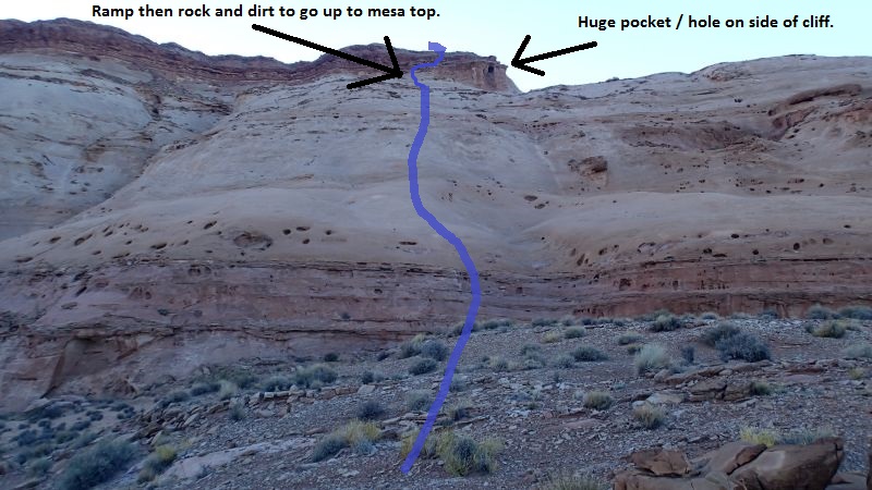
Your goal is to navigate
over to near that huge
pocket and scramble up
the ramp just to the
left (west) of it.
When get to this area
you can begin to see the
final cliff band you
will be climbing up
onto. A good
visual aid is the huge
pocket / hole in the
side of the cliff band.
Your goal is to navigate
over to near that huge
pocket and scramble up
the ramp just to the
left (west) of it.
From the bottom of this
side ravine / slot, note
a semi steep slickrock
slope to the left (west)
of the ravine.
Scramble you way up to the top of
this slope
(AngelCvExit19).
Walk north about 200
feet to the bottom of a
trough like drainage
running up
(AngelCvExit20). Follow
up this to go up toward
the end of the red rock
point above. You may
need to use your hands
in a few steep spots.
Walk up the slopes to
get to a ramp like area
just to the left of a
huge pocket on the side
of the cliff band above
(AngelCvExit21).
Work your way up the
ramp then scramble the
dirt and rock debris up
to the mesa top with
rolling dirt desert
above (AngelCvExit22).
Once up on the rolling
desert, follow use
trails west-ish roughly
following the Angel Cove
drainage on your right
(north) side.
About 0.25 miles up the
route will drop into a
wash (yAngelCvSF-Tp)
just above a shale
shelf. This is the
top of the South Fork of
Angel Cove.
Continue west up the
wash about 450 feet to
find one of many use
trails (AngelCvExit23)
leaving the wash going
northwest up the steep
dirt slopes.
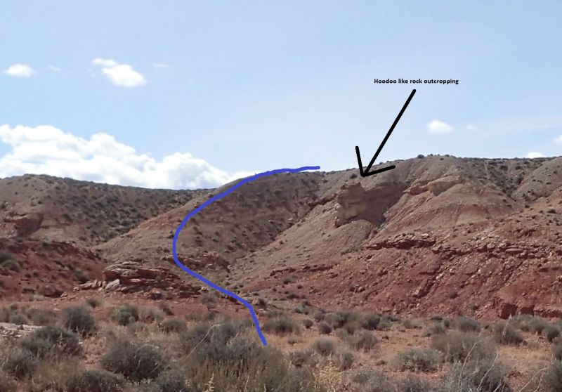 The better use trail in
this area seems to be
the one going up the
ridge to the left (west)
of a hoodoo like rock
feature protruding from
the dirt slopes.
The better use trail in
this area seems to be
the one going up the
ridge to the left (west)
of a hoodoo like rock
feature protruding from
the dirt slopes.
Once at the top of the
dirt slopes
(AngelCvExit24) walk
northwest about 0.2
miles through rolling
desert back to the
trailhead (tAngelCove).
Downloadable GPX files
available at
BG-Gear Store
(easier than manual entry and a great way to support
Bluugnome).
Waypoint naming convention and map symbol information can be found on the Glossary page.
Elevations are approximate.
BEFORE
manually entering coordinates set your system to WGS84 datum and Lat/Lon hddd.ddddd° coordinate format.
Inconsistent datum's and coordinate formats will result in location errors.
Click to show / expand the list of waypoints below........
| 1 Lost Angel - Drive in to Trailhead |
- extAngelTrlRd
Lat/Lon (WGS84): N 38.23613
W -110.64761
Elev: 4,810 Feet
Exit off highway 95 to an un-named road that leads to the Angel Point areas. The BLM has a sign saying this road leads to the Angel Trail.
- ex0100-0101DD
Lat/Lon (WGS84): N 38.24243
W -110.61040
Elev: NaN Feet
This is a Y in the road. Turning left on the road labeled 0100 leads northeast toward the Angel Trail and to the Angel Canyons. Turning right on the road labeled 0101 leads southeast toward the Beaver Canyons and Balcony Canyons Area.
- ex1002DD
Lat/Lon (WGS84): N 38.30851
W -110.55301
Elev: NaN Feet
Turn right onto a dirt road here marked 1002 to go to Angel Slot. Continue straight to go to Angel Cove or Fallen Angel Canyon.
- exAngelCove
Lat/Lon (WGS84): N 38.31323
W -110.55147
Elev: NaN Feet
Exit of of Road 0100 to the Angel Cove Canyon area. Turn right (northeast) onto an un-named road for about 0.35 miles to the TH for Angel Cove Canyons. To the left (northwest) road 0100 continues.
- tAngelCove
Lat/Lon (WGS84): N 38.31687
W -110.54710
Elev: 4,800 Feet
Parking at the trailhead for Angel Cove Canyon. Enough space for up to about 4 cars. 2WD can make it here but the road can have some sand and rough spots where high clearance may be required. If your car will not get to here you can park at the road junction about 0.36 miles before getting here and walk in.
Follow a use trail north down into the side of the North Fork of Angel Cove Drainage.
|
| 2 Lost Angel - Approach |
- tAngelCove
Lat/Lon (WGS84): N 38.31687
W -110.54710
Elev: 4,800 Feet
Parking at the trailhead for Angel Cove Canyon. Enough space for up to about 4 cars. 2WD can make it here but the road can have some sand and rough spots where high clearance may be required. If your car will not get to here you can park at the road junction about 0.36 miles before getting here and walk in.
Follow a use trail north down into the side of the North Fork of Angel Cove Drainage.
- jAngelCoveNFTp
Lat/Lon (WGS84): N 38.31818
W -110.54666
Elev: NaN Feet
To go down North Fork of Angel Cove, travel east down the wash.
To continue over to Hidden Angel or Lost Angel, continue up out of the north side of the drainage up a dirt side ravine about 400 feet to get to a dirt ravine to travel up another 350 feet up to rolling open desert above.
- wFallenAng01
Lat/Lon (WGS84): N 38.31976
W -110.54779
Elev: 4,850 Feet
Top of the slope up onto open rolling desert. To get Fallen Angel and Lost Angel look for the Flat Tops off in the distance to the northast and walk directly toward the Big Flat Top. The upper shallow dirt drainage of Fallen Angel is about 0.3 miles away and the upper shallow dirt drainage of Lost angel is about 0.2 miles farther.
- jFallenAngel
Lat/Lon (WGS84): N 38.32330
W -110.54677
Elev: 4,840 Feet
To go to Fallen Angel walk east and follow down the dirt runnels leading down. To continue to Lost Angel cross over this dirt drainage and continue northeast toward the Big Flat Top for about 0.2 miles to the next dirt draiange.
- jLostAngel
Lat/Lon (WGS84): N 38.32546
W -110.54677
Elev: 4,850 Feet
Upper end of a wide shallow dirt drainage dropping down to the east. Look east and follow down one of the two forks here that go on either side of a dirt hill. Both get you where you want to go but the drainage to left (north) goes to the preferred rap.
- yLostAngelTp
Lat/Lon (WGS84): N 38.32739
W -110.54480
Elev: 4,730 Feet
This fork of the wash goes from wide dirt to a more developed slot with some rock beginning to show.
|
| 3 Lost Angel - Canyon |
- yLostAngelTp
Lat/Lon (WGS84): N 38.32739
W -110.54480
Elev: 4,730 Feet
This fork of the wash goes from wide dirt to a more developed slot with some rock beginning to show.
- dLostAngR1-2
Lat/Lon (WGS84): N 38.32831
W -110.54332
Elev: NaN Feet
Rap 1 - 2 - Lost Angel.
Rap 1 anchored from one of many large rocks and drops 50 feet down a vertical chossy wall. Be careful of anchor placement as the rocks can be sharp. Also be careful of knocking loose rock down while on rappel.
Rap 2 very close to the bottom of rap 1, anchored from a boulder on the LDC side and drops about 20 feet. Rap 2 may be downclimable with a partner assist.
Note that the rap 1 others have used is from a dead tree in the other fork about 70 feet south and drops down to this same place. Dead trees can be a bad idea to rap from so this rappel is preferred.
- dLostAngR3-4
Lat/Lon (WGS84): N 38.32875
W -110.54256
Elev: NaN Feet
Rap 3 - 4 - Lost Angel.
Rap 3 anchored about head high on the LDC side from an arch in a hueco and drops about 65 feet down a slopped wall. Rap 3 is sloped enough to allow the drop to be done as a handline.
After rap 3 is a sloped trough like downclimb / scramble to the top of rap 4.
Rap 4 anchored from large choke stones and drops a total of about 60 feet over 2 stages. The first stage is sloped enough to be handlined but the second stage is vertical.
- dLostAngR5
Lat/Lon (WGS84): N 38.32908
W -110.54197
Elev: NaN Feet
Rap 5 - Lost Angel. About 100 feet downcaonyon of rap 4, Anchored from a large rock in the wash, drops about 60 feet over 2 stages.
Rap 5 can be bypassed by going up around on either side but both sides are a little sketchy. The RDC side involves going up over to a short ledge where a partner assist may be needed and the LDC side involves steeply sloped slabs to traverse.
- wLostAngel01
Lat/Lon (WGS84): N 38.32934
W -110.54154
Elev: NaN Feet
Semi spicy sloped downclimb of about 20 feet that can be bypassed LDC if desired. This is also the start of a V-shaped slot with scenic winding / undulating walls.
- wLostAngel02
Lat/Lon (WGS84): N 38.32956
W -110.54104
Elev: NaN Feet
V-shaped galumph / downclimb of about 15 feet.
- dLostAngR6
Lat/Lon (WGS84): N 38.33004
W -110.54064
Elev: 4,330 Feet
Rap 6 - Lost Angel. Anchored from a tree and travels about 180 feet to base of rappel. The first 50 feet of the rap needs to have the anchor webbing extended over 2 potholes that can be downclimbed through. This leaves only 130 feet of rope travel needed for the rappel. After the 2 potholes Rap 6 goes down a mostly vertical wall with the last 15 feet being downclimable.
Downclimbs into each of the potholes is about 15 feet with the second being moderately difficult but the anchor webbing can be used as a handline if needed. After 2nd pothole rap drops off vertical.
Note: During colder months this tree goes dormant and appears to be dead but comes to life as things warm up. If this tree does die off or does not look trust worthy you could build a deadman in one of the potholes or place choke stones in a crack out on the RDC side. Up on the RDC rim there is a lot of rock debris that can be farmed if needed.
- wLostAngel03
Lat/Lon (WGS84): N 38.33175
W -110.54045
Elev: NaN Feet
Drop of about 20 feet that is easily bypassed on the LDC using a use trail that is forming.
- yLostAngelBt
Lat/Lon (WGS84): N 38.33236
W -110.54112
Elev: 4,150 Feet
Bottom of Lost Angel Canyon where it meets the Dirty Devil River. Just before you get to the over grown vegetation at the side of the Dirty Devil, go up the dirt bank on the RDC (east) side to find use trails going east along the river bank just below a cliff band.
Also an arch way up on the RDC side is more visible if you look over there from the use trails as you exit the canyon. Look high up on the ciff rim to see it.
If you enjoy playing with Echos there is a big flat wall on the opposite side of the Dirty Devil a short distance after you start on the use trails along the river. Great echo play wall.
|
| 4 Lost Angel - Exit |
- yLostAngelBt
Lat/Lon (WGS84): N 38.33236
W -110.54112
Elev: 4,150 Feet
Bottom of Lost Angel Canyon where it meets the Dirty Devil River. Just before you get to the over grown vegetation at the side of the Dirty Devil, go up the dirt bank on the RDC (east) side to find use trails going east along the river bank just below a cliff band.
Also an arch way up on the RDC side is more visible if you look over there from the use trails as you exit the canyon. Look high up on the ciff rim to see it.
If you enjoy playing with Echos there is a big flat wall on the opposite side of the Dirty Devil a short distance after you start on the use trails along the river. Great echo play wall.
- wLostAngel04
Lat/Lon (WGS84): N 38.33214
W -110.53632
Elev: NaN Feet
Use trail starts up here to go from the base of the cliff band up to the top of the cliff band.
- wLostAngel05
Lat/Lon (WGS84): N 38.33196
W -110.53598
Elev: NaN Feet
Use trail now on top of the cliff band crosses over a draiange here. Cross the drainage and look for the use trail to continue up the dirt slopes to the southeast up dirt slopes.
- wLostAngel06
Lat/Lon (WGS84): N 38.32895
W -110.53481
Elev: NaN Feet
Top of a ridge dropping down from the rolling desert.
While in the rolling desert up here look south off in the distance for a hoodoo like tower up on the rim about 0.8 mile away. The hoo doo like tower is on the rim of Angel Cove canyon and your exit route will take you just beyond there to then go up to the rim.
- wLostAngel07
Lat/Lon (WGS84): N 38.32791
W -110.53505
Elev: NaN Feet
Bottom of the ridge dropping down from rolling deset above to the top of a slickrock pour off here. Veer right to travel southwest allong the top of the shelf just abovce the Dirty Devil. About 300 feet farther you will cross under an alcove.
- wLostAngel08
Lat/Lon (WGS84): N 38.32525
W -110.53734
Elev: NaN Feet
Route follows a short distance down a wash along the rim to a pour off here. Pass the pour off and continue south-ish along the rim.
- wLostAngel09
Lat/Lon (WGS84): N 38.32469
W -110.53757
Elev: NaN Feet
Pass over the top of another pour off and continue south-ish along the rim.
- wLostAngel10
Lat/Lon (WGS84): N 38.32301
W -110.53771
Elev: NaN Feet
Begin finding your way down in one of a few places to get down off the shelf down toward the Dirty Devil River as you get close to the Fallen Angel drainage.
- yFallenAngelBt
Lat/Lon (WGS84): N 38.32209
W -110.53787
Elev: 4,180 Feet
Bottom of Fallen Angel Canyon where it meets the Dirty Devil River. As you get close to the river look for a way up onto the bank to find use trails that will travel south down the river but high up on the ledges up out of the river along the base of the huge flat wall.
- wFallenAng04
Lat/Lon (WGS84): N 38.32153
W -110.53833
Elev: NaN Feet
Look for a way to scramble up over some boulder debris then down to use trails following along the base of the huge flat wall.
- sAngelPetro01
Lat/Lon (WGS84): N 38.31888
W -110.53742
Elev: 4,260 Feet
Rock art on the walls along the huge flat wall. To locate this start from the rubble pile at the south end of the wall and walk right at the base of the wall.
To find the first spot of art, look up and note a huge arch forming on the flat wall way up then a second smaller arch forming lower down. Just under the apex of the smaller arch is a rock that could be scrambled up onto. Just at the top of this rock is one area of rock art where you will find red paint making some symbols.
To find the second spot of art, travel south along the wall from the first spot about 100 feet to some carvings in the wall about head high.
- wFallenAng05
Lat/Lon (WGS84): N 38.31878
W -110.53726
Elev: NaN Feet
Trail is high up on a dirt ledge following along the wall. Depending on what use trail you followed along the wall you may find a rubble pile here you need to scramble up about 15 feet to find the use trails continuing. Shortly after here you will need to find your way down the rubble to the use trails thta travel right along the shore of the Dirty Devil.
- yAngelCove-Bt
Lat/Lon (WGS84): N 38.31778
W -110.53510
Elev: 4,150 Feet
Bottom of Angel Cove Canyon where it meets well worn trail running along the bank of the Dirty Devil River. Follow the trail southeast for the exit route.
- sAngelPetro02
Lat/Lon (WGS84): N 38.31766
W -110.53467
Elev: NaN Feet
Rock carvings in the wall about waist high. Not as many or as intricate as those north of Angel Cove though.
- AngelCvExit11
Lat/Lon (WGS84): N 38.31699
W -110.53365
Elev: NaN Feet
Trail has been following a sandstone wall then gets to an open sandy area here with a use trail starting up a sand hill. Go up the sand hill to continue the exit.
- AngelCvExit12
Lat/Lon (WGS84): N 38.31610
W -110.53310
Elev: NaN Feet
Trail briefly tops out. From here follow the use trail southish as it roughly follows another sandstone wall.
- AngelCvExit13
Lat/Lon (WGS84): N 38.31562
W -110.53275
Elev: NaN Feet
Trail tops out again briefly. Follow the trail southish roughly following the wall. There is a trail from here over to the wall where you can scramble up to the shelf above. The scramble up here can be a little tricky but is not overly difficult. If you want an easier way up continue southish to a much easier way up.
- AngelCvExit14
Lat/Lon (WGS84): N 38.31503
W -110.53246
Elev: NaN Feet
Trail tops out again with pretty level travel beyond. About 220 feet from here is a spot where the cliff band has dropped down to make an easy walk up onto the top.
- AngelCvExit15
Lat/Lon (WGS84): N 38.31443
W -110.53232
Elev: NaN Feet
Trail comes to an easy walk up onto the cliff band you have been following here. Follow the use trail southwestish roughly following the drainage to the south.
- AngelCvExit16
Lat/Lon (WGS84): N 38.31361
W -110.53297
Elev: NaN Feet
Follow the use trail over to and down in this side wash and follow westish about 400 feet up the wash.
- AngelCvExit17
Lat/Lon (WGS84): N 38.31332
W -110.53381
Elev: NaN Feet
Large pothole in the wash. Makes good navigation aid as this is shortly before leaving the wash to exit up to the mesa above.
- AngelCvExit18
Lat/Lon (WGS84): N 38.31329
W -110.53458
Elev: NaN Feet
Leave the wash here by walking northwest up the slickrock slope next to a side draiange commming in from the right (north) that has some small pothole like features. Walk up with the side drainage on your right (east).
As a navigation aid this is about 250 feet or down canyon of where the wash you are in begins to have some slickrock slot like features which you can see froom this point.
- AngelCvExit19
Lat/Lon (WGS84): N 38.31347
W -110.53549
Elev: NaN Feet
Top of the slope up out of the wash below and on the next higher shelf. Look northwest for the end of the red rock point on the mesa. Route find your way over toward the end of the point just to the left of a large obvious pocket in the cliff band. About 200 feet from herre is the bottom of a trough shaped drainage you cn scramble up on the way there.
- AngelCvExit20
Lat/Lon (WGS84): N 38.31401
W -110.53560
Elev: NaN Feet
Bottom of a trough like drainage running up. Follow up this to go up toward the end of the red rock point above. You may need to use your hands in a few steep spots.
- AngelCvExit21
Lat/Lon (WGS84): N 38.31506
W -110.53794
Elev: NaN Feet
Part way up a ramp just to the left of a large abvious pocket on the cliff side. Route find your way up the cliff side just left of the large pocket. You will need to climb up a couple spots and possibly assist one another.
- AngelCvExit22
Lat/Lon (WGS84): N 38.31537
W -110.53806
Elev: 4,740 Feet
On the mesa top just above the large pocket in the dlif side. Walk west in wide open dirt roughly following along the canyon on the right (north) which is Angel Cove Canyon.
- yAngelCvSF-Tp
Lat/Lon (WGS84): N 38.31503
W -110.54239
Elev: 4,755 Feet
Use trail for the exit from the Dirty Devil River meets the wash of Angel Cove Cayon here.
On the exit travel up the wash about 350 feet and exit to the north where convinient.
To drop down the South fork of Angel Canyon continue down the wash over a small shale shelf.
- AngelCvExit23
Lat/Lon (WGS84): N 38.31466
W -110.54392
Elev: NaN Feet
A few use trails up out of the wash developing here. For a visual aid look for a hoodoo like rock outcropping. The use trails are developing in the general vicinity of it with the best route being up the ridge to teh left (west) of the Hoodoo like outcropping.
- AngelCvExit24
Lat/Lon (WGS84): N 38.31498
W -110.54452
Elev: 4,840 Feet
Up on open flat desert. Walk northwest about 0.2 miles to the cars.
- tAngelCove
Lat/Lon (WGS84): N 38.31687
W -110.54710
Elev: 4,800 Feet
Parking at the trailhead for Angel Cove Canyon. Enough space for up to about 4 cars. 2WD can make it here but the road can have some sand and rough spots where high clearance may be required. If your car will not get to here you can park at the road junction about 0.36 miles before getting here and walk in.
Follow a use trail north down into the side of the North Fork of Angel Cove Drainage.
|