Canyoneering Route Description
Angel Cove Canyon - South Fork - 3A II
Dirty Devil Area, Utah.
03-30-16, 2 people, 1 Day (Travel time in route 4 hours)

Time Required - 3 to 4 hours
Distance - 3.3 miles Total, 0.6 miles Technical
Rappels - 8 Rappels, Longest Rappel 70 feet.
Elevation Range - 4800 - 4150 Feet
Shuttle Required - No Vehicle - High Clearance
or carefully driven passenger car
Permit Required - No
Rappelling and anchor gear, Ropes and or pull cords for rappels up
to 70 feet and 70 feet of 1 inch webbing for sling placement.
Angel Cove Canyon is a fun place to visit for a half day
canyon. With Angel Cove Canyon being short you can loop it to do the Norht
Fork then when the exit route crosses over the South Fork drop in and do the
South Fork then follow the exit again all the way out to the cars. Doing
both forks will take most of the day but not all of it.
The last road you turn off onto may have some rough
spots (depending on when it was last maintained) that a passenger car may
not like. If you find it too rough to travel there is space to get a
couple cars parked off to the side of the road at the previous road
junction. From there you can walk the 0.36 miles of dirt road instead
of drive in.
Angel Cove is generally dry. If there have been
recent rains you may find a couple spots that can hold water to waist deep.
70 feet of webbing was recomended since rap 5 in the
main fork (rap 7 on this route) would use
close to 30 feet of it if you need to replace that. THis route seems
to get less travel than the North Fork and has more rappels so more webbing
on hand is a good idea.
If doing the Sputh Fork and using the early exit to
bypass the final 2 rappels the longest rap will be 55 feet. The
longest rappels are the final raps both at 70 feet.
As you travel down canyon after the confluence you may
catch sight of a scenic arch very high up on teh RDC wall but youll have to
keep your eyes open as this is easy to miss.
To get to the Trailhead
From the junction of highway 95 and highway 24 in Hanksville
Utah, drive 10.2 miles south on highway 95 to an un-named dirt
road on the left (extAngelTrlRd). The road has a BLM sign
saying it goes out to the Angel Trail. Turn left (east) on the
Angel Trail road and ignore smaller dirt roads that branch off.
2.4 miles from the highway will be a Y in the road (ex0100-0101DD).
Turn left at this Y and continue toward the Angel Canyons on the
road labeled 0100.
Stay on road 0100 for
5.9 miles to a turn off to another road on the right (ex1002DD).
Do not turn right on this road but instead continue north for
another 0.33 miles to an un-marked dirt road on the right
(exAngelCove). Turn right onto the un-marked road and drive 0.36
miles to a large parking area (tAngelCove) to start the route.
Note: Some vehicles may have issues on the last
part of the road if the road has not been recently maintained.
If this is the case you can park at the junction and walk in
0.36 miles to the TH.
To leave the Exit Vehicle / Escape Pod
No exit vehicle is needed. This is done as a loop route.
GPS coordinate information listed at the bottom. For information about waypoint naming and map symbols, refer to the
Glossary page.

Click the links for maps of the route.
Map of the drive into the route.
Map of the entire route.
The Approach:
From parking area /
trailhead (tAngelCove),
walk about 0.2 miles
southeast to the top of
steep dirt slopes
(AngelCvExit24) dropping
down to a wash below.
Drop down the dirt
slopes into the wash
(AngelCvExit23) then
turn left to walk east
down the wash.
A few hundred feet down
the wash will be a small
shale shelf
(yAngelCvSF-Tp) and is
the start of the South
Fork of Angel Cove
Canyon.
The Canyoneering / Technical Section:
From the small
shale shelf in the wash
(yAngelCvSF-Tp) scramble
down it and continue
down the wash.
About 150 feet down
canyon is rap 1
(dAngelCvSF-R1) which
drops about xx feet from
a cairn anchor but is
easily bypassed walking
around on the LDC side
then down a shale slope
to the top of rap 2
which is about 175 feet
down canyon.
Rap 2 (dAngelCvSF-R2) is
anchored from a rock
pile and drops about 55
feet down a vertical
wall. The anchor is
after downclimbing a
ledge of about 6 feet do
get to it. Walk
down canyon about 350
feet to rap 3.
Rap 3 (dAngelCvSF-R3) is
anchored from large
boulder at the top of
the drop and drops about
55 feet.
From the bottom of rap 3
the canyon begins to
slot up and become
deeper and more narrow.
Shortly after rap 3 is a
downclimb of about 15
feet in a V-slot.
Rap 4 (dAngelCvSF-R4) is
about 200 feet down
canyon of rap 3, is
anchored from large rock
protruding from the
canyon floor and drops
about 25 feet over a
boulder between narrow
walls.
Rap 5 is about 125 feet
down canyon with a few
scrambling downclimbs
between.
Rap 5 (dAngelCvSF-R5) is
anchored from one of the
boulders at the top
forming a false floor
and drops about 35 feet.
The first 10 feet are
downclimbable down the
slot below the boulders.
After rap 5 are a few
short downclimb between
narrow walls and one
stem style downclimb of
about 10 feet.
Rap 6 (dAngelCvSF-R6) is
about 150 feet down
canyon of rap 5 and is
anchored from a large
chokestone at the top of
the drop and dropps
about 20 feet down a
shute. Rap 6 can be
downclimbed with little
difficulty.
After rap 6 are 3
downclimbs of 10 to 15
feet each before getting
to the confluence of the
North and South Forks of
Angel Cove about 300
feet down canyon
(jAngelCoveConf).
Just down canyon of this
confluence are 7 easy
downclimbs of 6 to 12
feet (the last one under
a boulder and is a
little spicy). This
section has the capacity
to hold water after
recent rains but only to
about waist deep.
Note:
As you travel down canyon
after the confluence you may
catch sight of a scenic arch
very high up on teh RDC wall
but youll have to keep your
eyes open as this is easy to
miss.
Just after the
downclimbs is a short
flat patio like area as
the canyon begins to
sweep left and chnge
character to being a
little wider.
Just after the two patio
section are two potholes
(wAngelCv10) that can be
bypassed on ledges on
the RDC side with the
second one being a
little harder to bypass.
If you can not bypass
the second one you could
have chest deep water if
full.
While in this section
look high up on the RDC
wall for a scenic arch
forming about 50 feet
down canyon.
Shortly after the canyon
will open up to a very
wide flat area where you
can walk over onto the
RDC (south) side over to
open dirt rolling
desert. This is
where you can exit the
canyon early and miss
the last two rappels and
make the day a little
shorter. Or walk
over to rap 4 which
drops down the water
course in this same
area.
To Exit Early
walk along the RDC side
near the side of rap 5
and route find your way
about 0.3 miles south to
intersect with the exit
route.
Rap 4 (dAngelCv-R4) is
anchored from a large
boulder about 20 feet
back and drops about 70
feet down a vertical
wall with a ledge about
50 feet down. If the
webbing is not extended
to the lip it may
require 90 feet of rope
travel.
Rap 5 (dAngelCv-R5) is
in the chamber like area
below rap 4 is anchored
from a cairn anchor and
drops about 70 feet.
From the bottom of rap 5
walk the wash about 200
feet out to the Dirty
Devil River
(yAngelCove-Bt) and turn
right (southeast) to
follow use trails.
The Exit:
From end
of the wash where it
gets to the Dirty Devil
(yAngelCove-Bt). turn
right to walk south on
well defined use trail.
Note:
Very shortly after starting
on the use trails, look
about waist high on the
cliff wall for rock art
carvings(sAngelPetro02).
These are not as nice of
rock art as the set to the
north of here but worth a
quick look just to check
them out. Better rock
art carvings and some paint
can be found about 750 feet
north on the cliff walls of
a HUGE flat wall the use
trails go under. More
details of how to locate
these can be found on the
route description for Lost
Angel and Hidden Angel.
Continue along the use
trail for almost 500
feet to where it starts
up a sand hill
(AngelCvExit11).
About 375 feet further
the trail briefly tops
out (AngelCvExit12) then
drops back down again.
About 200 feet further
the trail briefly tops
out again
(AngelCvExit13).
There is a spot here you
can upclimb to get to
the next higher level
that may be moderately
difficult. If you
want to climb up here
you can shortcut the
route a little.
If you did not climb up
yet, follow the use
trail about 200 feet to
another top out
(AngelCvExit14) then
about 220 feet to yet
one more top out
(AngelCvExit15) where it
is an easy walk up to
the shelf above.
Once up on the shelf
above, veer right to
walk southwest then west
working your way over to
a draiange
(AngelCvExit16) going up
to the west.
When you get to a large
pothole in the wash
(AngelCvExit17) exit the
wash on the right
(north) side and route
find along the slickrock
for about 200 feet to
the bottom of a steep
side ravine / slot with
small potholes visible
up in it
(AngelCvExit18).
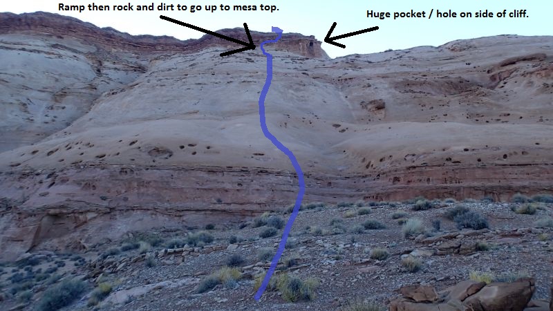 When get to this area
you can begin to see the
final cliff band you
will be climbing up
onto. A good
visual aid is the huge
pocket / hole in the
side of the cliff band.
Your goal is to navigate
over to near that huge
pocket and scramble up
the ramp just to the
left (west) of it.
When get to this area
you can begin to see the
final cliff band you
will be climbing up
onto. A good
visual aid is the huge
pocket / hole in the
side of the cliff band.
Your goal is to navigate
over to near that huge
pocket and scramble up
the ramp just to the
left (west) of it.
From the bottom of this
side ravine / slot, note
a semi steep slickrock
slope to the left (west)
of the ravine.
Scramble you way up to the top of
this slope
(AngelCvExit19).
Walk north about 200
feet to the bottom of a
trough like drainage
running up
(AngelCvExit20). Follow
up this to go up toward
the end of the red rock
point above. You may
need to use your hands
in a few steep spots.
Walk up the slopes to
get to a ramp like area
just to the left of a
huge pocket on the side
of the cliff band above
(AngelCvExit21).
Work your way up the
ramp then scramble the
dirt and rock debris up
to the mesa top with
rolling dirt desert
above (AngelCvExit22).
Once up on the rolling
desert, follow use
trails west-ish roughly
following the Angel Cove
drainage on your right
(north) side.
About 0.25 miles up the
route will drop into a
wash (yAngelCvSF-Tp)
just above a shale
shelf. This is the
top of the South Fork of
Angel Cove.
Continue west up the
wash about 450 feet to
find one of many use
trails (AngelCvExit23)
leaving the wash going
northwest up the steep
dirt slopes.
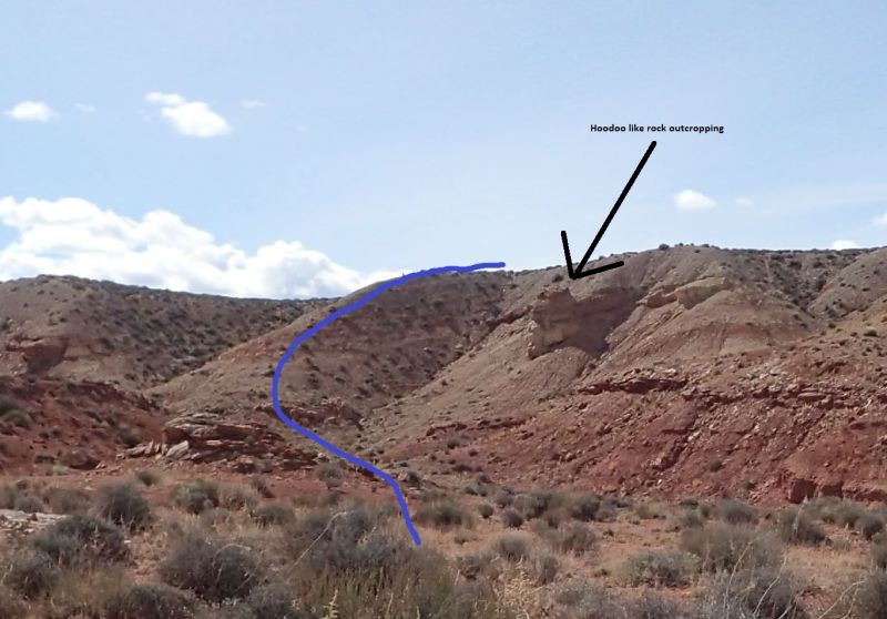 The better use trail in
this area seems to be
the one going up the
ridge to the left (west)
of a hoodoo like rock
feature protruding from
the dirt slopes.
The better use trail in
this area seems to be
the one going up the
ridge to the left (west)
of a hoodoo like rock
feature protruding from
the dirt slopes.
Once at the top of the
dirt slopes
(AngelCvExit24) walk
northwest about 0.2
miles through rolling
desert back to the
trailhead (tAngelCove).
Downloadable GPX files
available at
BG-Gear Store
(easier than manual entry and a great way to support
Bluugnome).
Waypoint naming convention and map symbol information can be found on the Glossary page.
Elevations are approximate.
BEFORE
manually entering coordinates set your system to WGS84 datum and Lat/Lon hddd.ddddd° coordinate format.
Inconsistent datum's and coordinate formats will result in location errors.
Click to show / expand the list of waypoints below........
| 1 Angel Cove - Drive in to Trailhead |
- extAngelTrlRd
Lat/Lon (WGS84): N 38.23613
W -110.64761
Elev: 4,810 Feet
Exit off highway 95 to an un-named road that leads to the Angel Point areas. The BLM has a sign saying this road leads to the Angel Trail.
- ex0100-0101DD
Lat/Lon (WGS84): N 38.24243
W -110.61040
Elev: NaN Feet
This is a Y in the road. Turning left on the road labeled 0100 leads northeast toward the Angel Trail and to the Angel Canyons. Turning right on the road labeled 0101 leads southeast toward the Beaver Canyons and Balcony Canyons Area.
- ex1002DD
Lat/Lon (WGS84): N 38.30851
W -110.55301
Elev: NaN Feet
Turn right onto a dirt road here marked 1002 to go to Angel Slot. Continue straight to go to Angel Cove or Fallen Angel Canyon.
- exAngelCove
Lat/Lon (WGS84): N 38.31323
W -110.55147
Elev: NaN Feet
Exit of of Road 0100 to the Angel Cove Canyon area. Turn right (northeast) onto an un-named road for about 0.35 miles to the TH for Angel Cove Canyons. To the left (northwest) road 0100 continues.
- tAngelCove
Lat/Lon (WGS84): N 38.31687
W -110.54710
Elev: 4,800 Feet
Parking at the trailhead for Angel Cove Canyon. Enough space for up to about 4 cars. 2WD can make it here but the road can have some sand and rough spots where high clearance may be required. If your car will not get to here you can park at the road junction about 0.36 miles before getting here and walk in.
Follow a use trail north down into the side of the North Fork of Angel Cove Drainage.
|
| 2 Angel Cove NORTH Fork - Approach and Canyon down to confluence |
- tAngelCove
Lat/Lon (WGS84): N 38.31687
W -110.54710
Elev: 4,800 Feet
Parking at the trailhead for Angel Cove Canyon. Enough space for up to about 4 cars. 2WD can make it here but the road can have some sand and rough spots where high clearance may be required. If your car will not get to here you can park at the road junction about 0.36 miles before getting here and walk in.
Follow a use trail north down into the side of the North Fork of Angel Cove Drainage.
- jAngelCoveNFTp
Lat/Lon (WGS84): N 38.31818
W -110.54666
Elev: NaN Feet
To go down North Fork of Angel Cove, travel east down the wash.
To continue over to Hidden Angel or Lost Angel, continue up out of the north side of the drainage up a dirt side ravine to get to rolling open desert.
- yAngelCvNF-Tp
Lat/Lon (WGS84): N 38.31832
W -110.54598
Elev: 4,720 Feet
Top of North Fork Angel Cove. A small shelf in wash to easily scramble down.
North Fork of Angel Cove Canyon - 3AII - Longest Rap 70 feet Small Pack advised.
- dAngelCvNF-R1
Lat/Lon (WGS84): N 38.31865
W -110.54473
Elev: NaN Feet
Rap 1 - Angel Cove NF. Anchored from rocks about 5 feet back and drops about 40 feet down a sloped wall that is sloped enough that a hand line can be used instead of rappelling.
A little down canyon after rap 1 is an eaasy downclimb of about 8 feet.
- dAngelCvNF-R2
Lat/Lon (WGS84): N 38.31913
W -110.54310
Elev: NaN Feet
Rap 2 - Angel Cove NF. Anchored from a rock protruding from the canyon floor and drops about 15 feet and can be carefully downclimbed using a handline if desired.
- wAngelCvNF01
Lat/Lon (WGS84): N 38.31923
W -110.54281
Elev: NaN Feet
Side canyon comes in from LDC (north). Can go up about 100 feet before getting to an upclimb.
Down canyon of here is easy walking with a couple spots to easily scramble over.
- dAngelCvNF-R3
Lat/Lon (WGS84): N 38.31912
W -110.54198
Elev: NaN Feet
Rap 3 - Angel Cove NF. Anchored from a boulder and drops about 25 feet from boulder to ground. Top half of this rappel can be downclimbed while the second half is under cut and would not be easy to downclimb or upclimb with out a handline and an aggressive partner assist.
Over the next 400 feet down canyon after rap 3 are three easy downclimbs ranging from 6 to 8 feet each followed by two more drops of about 12 to 15 feet each that can be downclimbed / slid down (partner assist may be helpful).
Soon after is a rock fall area to walk through and just after is a trough like section that is mostly easy walking with a few very small easy drops along the way.
- wAngelCvNF02
Lat/Lon (WGS84): N 38.31863
W -110.53943
Elev: NaN Feet
Long trough like area with mostly easy walking.
- jAngelCoveConf
Lat/Lon (WGS84): N 38.31735
W -110.53834
Elev: 4,410 Feet
Just down canyon of this confluence are 7 easy downclimbs of 6 to 12 feet (the last one under a boulder and is a little spicy). This section has the capacity to hold water after recent rains but only to about waist deep.
Just after the downclimbs is a short flat patio like area as the canyon begins to sweep left and chnge character to being a little wider.
|
| 3 Angel Cove SOUTH Fork - Approach and Canyon down to confluence |
- tAngelCove
Lat/Lon (WGS84): N 38.31687
W -110.54710
Elev: 4,800 Feet
Parking at the trailhead for Angel Cove Canyon. Enough space for up to about 4 cars. 2WD can make it here but the road can have some sand and rough spots where high clearance may be required. If your car will not get to here you can park at the road junction about 0.36 miles before getting here and walk in.
Follow a use trail north down into the side of the North Fork of Angel Cove Drainage.
- AngelCvExit24
Lat/Lon (WGS84): N 38.31498
W -110.54452
Elev: 4,840 Feet
Up on open flat desert. Walk northwest about 0.2 miles to the cars.
- AngelCvExit23
Lat/Lon (WGS84): N 38.31466
W -110.54392
Elev: NaN Feet
A few use trails up out of the wash developing here. For a visual aid look for a hoodoo like rock outcropping. The use trails are developing in the general vicinity of it with the best route being up the ridge to teh left (west) of the Hoodoo like outcropping.
- yAngelCvSF-Tp
Lat/Lon (WGS84): N 38.31503
W -110.54239
Elev: 4,755 Feet
Use trail for the exit from the Dirty Devil River meets the wash of Angel Cove Cayon here.
On the exit travel up the wash about 350 feet and exit to the north where convinient.
To drop down the South fork of Angel Canyon continue down the wash over a small shale shelf.
- dAngelCvSF-R1
Lat/Lon (WGS84): N 38.31542
W -110.54213
Elev: NaN Feet
Rap 1 - Angel Cove South Fork. Anchored from a rock pile and drops about 20 feet down a very chossy wall. Easily bypassed on the LDC side by walking down the shale slope about 150 feet down canyon.
- dAngelCvSF-R2
Lat/Lon (WGS84): N 38.31559
W -110.54157
Elev: NaN Feet
Rap 2 - Angel Cove South Fork. Anchored from a rock pile and drops about 55 feet down a vertical wall. The anchor is after downclimbing a ledge of about 6 feet do get to it.
- dAngelCvSF-R3
Lat/Lon (WGS84): N 38.31623
W -110.54067
Elev: NaN Feet
Rap 3 - Angel Cove South Fork. Anchored from large boulder at the top of the drop and drops about 55 feet.
From the bottom of rap 3 the canyon begins to slot up and become deeper and more narrow. Shortly after rap 3 is a downclimb of about 15 feet in a V-slot.
- dAngelCvSF-R4
Lat/Lon (WGS84): N 38.31652
W -110.54001
Elev: NaN Feet
Rap 4 - Angel Cove South Fork. Anchored from large rock protruding from the canyon floor and drops about 25 feet over a boulder between narrow walls.
Rap 5 is about 125 feet down canyon with a few scrambling downclimbs between.
- dAngelCvSF-R5
Lat/Lon (WGS84): N 38.31667
W -110.53961
Elev: NaN Feet
Rap 5 - Angel Cove South Fork about 120 feet down canyon of rap 4. Anchored from one of the boulders at the top forming a false floor and drops about 35 feet. The first 10 feet are downclimbable down the slot below the boulders.
After rap 5 are a few short downclimb between narrow walls and one stem style downclimb of about 10 feet.
- dAngelCvSF-R6
Lat/Lon (WGS84): N 38.31689
W -110.53919
Elev: NaN Feet
Rap 6 - Angel Cove SF. Anchored from a large chokestone at the top of the drop and dropps about 20 feet down a shute. Rap 6 can be downclimbed with little difficulty.
After rap 6 are 3 downclimbs of 10 to 15 feet each before getting to the confluence of the North and South Forks of Angel Cove about 300 feet down canyon.
- jAngelCoveConf
Lat/Lon (WGS84): N 38.31735
W -110.53834
Elev: 4,410 Feet
Just down canyon of this confluence are 7 easy downclimbs of 6 to 12 feet (the last one under a boulder and is a little spicy). This section has the capacity to hold water after recent rains but only to about waist deep.
Just after the downclimbs is a short flat patio like area as the canyon begins to sweep left and chnge character to being a little wider.
|
| 4 Angel Cove - Canyon from Confluence to End |
- jAngelCoveConf
Lat/Lon (WGS84): N 38.31735
W -110.53834
Elev: 4,410 Feet
Just down canyon of this confluence are 7 easy downclimbs of 6 to 12 feet (the last one under a boulder and is a little spicy). This section has the capacity to hold water after recent rains but only to about waist deep.
Just after the downclimbs is a short flat patio like area as the canyon begins to sweep left and chnge character to being a little wider.
- wAngelCv10
Lat/Lon (WGS84): N 38.31661
W -110.53650
Elev: NaN Feet
This is just after a short patio were there are two potholes that can be bypassed on ledges on the RDC side with the second one being a little harder to bypass. If you can not bypass the second one you could have chest deep water if full.
While in this section look high up on the RDC wall for a scenic arch forming about 50 feet down canyon.
- dAngelCv-R4
Lat/Lon (WGS84): N 38.31688
W -110.53535
Elev: 4,260 Feet
Angel Cove Rap 4. Anchored from a large boulder about 20 feet back and drops about 70 feet down a vertical wall with a ledge about 50 feet down. If the webbing is not extended to the lip it may require 90 feet of rope travel.
This is out where the canyon opens up to a wide ledge / shelf on the RDC side which can be used as an alternate exit making the lower portion of the canyon optional.
- dAngelCv-R5
Lat/Lon (WGS84): N 38.31722
W -110.53532
Elev: NaN Feet
Rap 5 Angle Cove Canyon. Anchored from a cairn anchor and drops about 70 feet.
From here walk the wash out to the Dirty Devil River and turn right (southeast) to follow use trails.
- yAngelCove-Bt
Lat/Lon (WGS84): N 38.31778
W -110.53510
Elev: 4,150 Feet
Bottom of Angel Cove Canyon where it meets well worn trail running along the bank of the Dirty Devil River. Follow the trail southeast for the exit route.
|
| 5 Angel Cove - Exit |
- yAngelCove-Bt
Lat/Lon (WGS84): N 38.31778
W -110.53510
Elev: 4,150 Feet
Bottom of Angel Cove Canyon where it meets well worn trail running along the bank of the Dirty Devil River. Follow the trail southeast for the exit route.
- sAngelPetro02
Lat/Lon (WGS84): N 38.31766
W -110.53467
Elev: NaN Feet
Rock carvings in the wall about waist high. Not as many or as intricate as those north of Angel Cove though.
- AngelCvExit11
Lat/Lon (WGS84): N 38.31699
W -110.53365
Elev: NaN Feet
Trail has been following a sandstone wall then gets to an open sandy area here with a use trail starting up a sand hill. Go up the sand hill to continue the exit.
- AngelCvExit12
Lat/Lon (WGS84): N 38.31610
W -110.53310
Elev: NaN Feet
Trail briefly tops out. From here follow the use trail southish as it roughly follows another sandstone wall.
- AngelCvExit13
Lat/Lon (WGS84): N 38.31562
W -110.53275
Elev: NaN Feet
Trail tops out again briefly. Follow the trail southish roughly following the wall. There is a trail from here over to the wall where you can scramble up to the shelf above. The scramble up here can be a little tricky but is not overly difficult. If you want an easier way up continue southish to a much easier way up.
- AngelCvExit14
Lat/Lon (WGS84): N 38.31503
W -110.53246
Elev: NaN Feet
Trail tops out again with pretty level travel beyond. About 220 feet from here is a spot where the cliff band has dropped down to make an easy walk up onto the top.
- AngelCvExit15
Lat/Lon (WGS84): N 38.31443
W -110.53232
Elev: NaN Feet
Trail comes to an easy walk up onto the cliff band you have been following here. Follow the use trail southwestish roughly following the drainage to the south.
- AngelCvExit16
Lat/Lon (WGS84): N 38.31361
W -110.53297
Elev: NaN Feet
Follow the use trail over to and down in this side wash and follow westish about 400 feet up the wash.
- AngelCvExit17
Lat/Lon (WGS84): N 38.31332
W -110.53381
Elev: NaN Feet
Large pothole in the wash. Makes good navigation aid as this is shortly before leaving the wash to exit up to the mesa above.
- AngelCvExit18
Lat/Lon (WGS84): N 38.31329
W -110.53458
Elev: NaN Feet
Leave the wash here by walking northwest up the slickrock slope next to a side draiange commming in from the right (north) that has some small pothole like features. Walk up with the side drainage on your right (east).
As a navigation aid this is about 250 feet or down canyon of where the wash you are in begins to have some slickrock slot like features which you can see froom this point.
- AngelCvExit19
Lat/Lon (WGS84): N 38.31347
W -110.53549
Elev: NaN Feet
Top of the slope up out of the wash below and on the next higher shelf. Look northwest for the end of the red rock point on the mesa. Route find your way over toward the end of the point just to the left of a large obvious pocket in the cliff band. About 200 feet from herre is the bottom of a trough shaped drainage you cn scramble up on the way there.
- AngelCvExit20
Lat/Lon (WGS84): N 38.31401
W -110.53560
Elev: NaN Feet
Bottom of a trough like drainage running up. Follow up this to go up toward the end of the red rock point above. You may need to use your hands in a few steep spots.
- AngelCvExit21
Lat/Lon (WGS84): N 38.31506
W -110.53794
Elev: NaN Feet
Part way up a ramp just to the left of a large abvious pocket on the cliff side. Route find your way up the cliff side just left of the large pocket. You will need to climb up a couple spots and possibly assist one another.
- AngelCvExit22
Lat/Lon (WGS84): N 38.31537
W -110.53806
Elev: 4,740 Feet
On the mesa top just above the large pocket in the dlif side. Walk west in wide open dirt roughly following along the canyon on the right (north) which is Angel Cove Canyon.
- yAngelCvSF-Tp
Lat/Lon (WGS84): N 38.31503
W -110.54239
Elev: 4,755 Feet
Use trail for the exit from the Dirty Devil River meets the wash of Angel Cove Cayon here.
On the exit travel up the wash about 350 feet and exit to the north where convinient.
To drop down the South fork of Angel Canyon continue down the wash over a small shale shelf.
- AngelCvExit23
Lat/Lon (WGS84): N 38.31466
W -110.54392
Elev: NaN Feet
A few use trails up out of the wash developing here. For a visual aid look for a hoodoo like rock outcropping. The use trails are developing in the general vicinity of it with the best route being up the ridge to teh left (west) of the Hoodoo like outcropping.
- AngelCvExit24
Lat/Lon (WGS84): N 38.31498
W -110.54452
Elev: 4,840 Feet
Up on open flat desert. Walk northwest about 0.2 miles to the cars.
- tAngelCove
Lat/Lon (WGS84): N 38.31687
W -110.54710
Elev: 4,800 Feet
Parking at the trailhead for Angel Cove Canyon. Enough space for up to about 4 cars. 2WD can make it here but the road can have some sand and rough spots where high clearance may be required. If your car will not get to here you can park at the road junction about 0.36 miles before getting here and walk in.
Follow a use trail north down into the side of the North Fork of Angel Cove Drainage.
|