Canyoneering Route Description
Bee Canyon - 3A III
Mount Charleston, Nevada.
Spring Mountain National Recreation Area.
04-29-16, 3 people, 1 Day (Travel time in route 6.75 hours)
 Went up the optional south ridge and to Bee Peak then down Bee Canyon.
Time Required - 3 to 5 hours for the lower
approach. (4 to 6 hours for optional south ridge to Bee
Peak then down Bee Canyon)
Distance - 5.2 miles Total, 0.4 miles Technical
- for lower approach
Rappels - 5 Rappels, Longest Rappel 70 feet.
Elevation Range - 2970 - 3970 Feet (if
going up to Bee Peak 4800 feet)
Shuttle Required - No Vehicle - Passenger
carefully driven
- High Clearance preferred.
Permit Required - No
Rappelling and anchor gear, Ropes and or pull cords for rappels up
to 70 feet and 50 feet of 1 inch webbing for sling placement. A
couple anchors are set back a ways and need to be extended and this
canyon is not frequently done so odds are good you will be replacing
webbing.
Bee Canyon offers a desert hike and a short canyon not too
far from town. Bee Canyon does not offer anything epic but is a fun way to spend
a few hours with friends. Bee Peak is described in one of Courtney
Purcell's books of peaks around Las Vegas. Thanks to Kevin Humes for
inviting us on his quest to one of the most unfulfilling peak hikes I have been
on. I was more interested in the lower canyon so I sat down and enjoyed
the solitude while the Kevin and Tracy did the last 0.3 miles out then back to
Bee Peak.
While this route is in lesser traveled areas, be aware
there are a lot of places nearby that are commonly used as desert shooting
areas. While hiking in and out, it is common to hear gun shots.
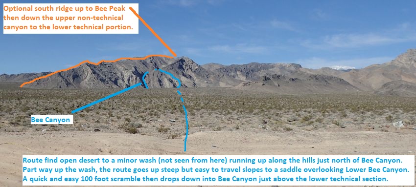
The approach route described here goes up and over the
northern side of the canyon to drop in just above the lower technical
section of Bee Canyon and does not take you to Bee Peak or down the upper
non-technical portion of the canyon. While route finding across open desert,
you will cross a few deep washes where you will need to drop down into then
back up the other side. There are also various animal trails all over the
place, don't let the animal trails lead you to the wrong place. Good
navigation skills with map or GPS will help keep you on track.
Alternate approach and trip to near by Bee Peak:
Alternatively you can travel farther across open desert go up the ridge on
the south side (not the north side as described here) of the canyon then
follow that ridge all the way to Bee Peak. From Bee Peak descend the
upper non-technical portion of Bee Canyon before getting back down to the
lower technical portion. Hiking the ridge up to Bee Peak is relatively
straight forward and easy to figure out but adds significant elevation gain
and distance to the route, so it is not described here. If you are one who
likes going to minor peaks in random places in the desert, Bee Peak at 4800
feet is for you.
Note / Navigation Aid:
While
following the approach route take a look back toward the car park a few
times to get a feel for what to look for after exiting Bee Canyon. The white
patch for the car parking is easy to identify from a distance but the car
may not be easy to spot.
To get to the Trailhead
High clearance recommended. Carefully driven passenger car can
make it.
From Las Vegas, drive north on I-95 out of town. A few miles out
of town you will pass the exit for Snow Canyon. Continue north
on the 95 for another 4.5 miles to a turn off on the left (west)
side of the road (ExTheMost). I called the road The Most since
that was painted on some concrete nearby on my first visit.
There is no turn off for this side road from the north bound
side. You will need find a way to cross the highway or drive up
to the next exit and double back on the south bound side to get
to the turn off.
Drive west on this rough dirt road ignoring turn offs onto power
line roads on the way. 0.7 miles from the highway will be the
parking area in a target shooting area in a large white patch of
dirt (pkBeeCanyon).
This white area of dirt is pretty easy to see in the distance so
it makes a great navigation aid for the hike back to the car
from the canyon exit.
To leave the Exit Vehicle / Escape Pod
No exit vehicle is needed. This is done as a loop route.
GPS coordinate information listed at the bottom. For information about waypoint naming and map symbols, refer to the
Glossary page.

Click the links for maps of the route.
Map of the entire route.
Map of last part of approach and the technical section.
The Approach:
From parking spot (pkBeeCanyon)
route find open desert
to a minor wash running
up the hills just north
of Bee Canyon. Note that
the minor wash is not
seen from the parking
area and will come into
view as you get closer.
Follow the blue line in
the route image.
 Viewed from near the parking area. Follow the blue line toward Bee Peak.
 As you get closer to the mountains and Bee Canyon this will be your view.
Follow the blue line up the wash then up the hill to the side of of Bee Canyon.
As you get closer to the mountains and Bee Canyon this will be your view.
Follow the blue line up the wash then up the hill to the side of of Bee Canyon.
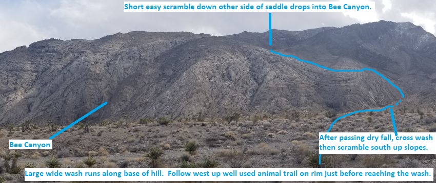
As you get close to the base of the mountains (BeeCyn10), follow the well used
animal trails west up along the right (north) side rim of the wash.
About 700 feet up the trail along the wash rim (BeeCyn11) the trail has one
switch back in it going up about 15 feet.
About 200 feet farther the
trail drops into the wash
(BeeCyn12) just above a dry
fall.
About 100 feet up the wash,
the wash starts a sharp bend
to the left (BeeCyn13).
Leave the wash and scramble
up the left (south) side and
roughly follow the drainage
but staying high up on the
rim for easier travel
Faintly used animal trails
follow the rim and make
walking a bit easier.
About 350 feet farther the
route gets close to dropping
back in the wash where the
rim is low again (BeeCyn14).
Veer left (southeast) away
from the drainage and begin
scrambling up steep but easy
slopes. As you go up look
for animal trails veering
more left (east) to go
around a point for easier
travel.
About 500 feet up the slopes
the route follows animal
trails around a point
(BeeCyn15) then contours
over into another drainage.
About 200 feet farther the
route crosses another
drainage (BeeCyn16).
Continue southeast up slope
about 500 feet to a small
saddle.
From the small saddle
(BeeCyn17) looking south
down into Bee Canyon.
Scramble down the slopes
about 100 feet and into Bee
Canyon.
Once in Bee Canyon
(BeeCyn18) turn left and
walk east down canyon about
70 feet to where the canyon
starts to slot up (yBeeCanyonTp).
The Canyoneering / Technical Section:
From where the
canyon starts to slot up
(yBeeCanyonTp) walk a
rubble filled wash and a
few easy scrambles.
About 150 feet down
canyon are about 4
downclimbs (BeeCyn19) of
about 6 feet each.
Shortly down canyon is
rap 1.
Rap 1 (dBeeCynR1-2) is
anchored LDC from a rock
outcropping about 10
feet back and drops
about 30 feet with a
ledge about 8 feet down.
Rap 2 just after rap 1
is anchored from a cairn
anchor and drops about
70 feet.
Continue down canyon
with a lot of short easy
scrambling and
downclimbing for about
1000 feet to the next
rap.
Rap 3 (dBeeCynR3) is
anchored from a rock
about 15 feet back from
the drop and drops about
25 feet. There is a
vertical downclimb of
about 8 feet just before
the rap where some
people may want a
partner assist.
Rap 4 is shortly down
canyon.
Rap 4 (dBeeCynR4-5 )
anchored from a rock
about 20 feet back and
drops about 25 feet down
into a pothole about 10
feet deep. The pothole
is easily climbed out of
and if full of water you
can get over it while on
rap with a little
effort.
Rap 5 just around the
corner from rap 4 and
drops about 60 feet down
a sloped section of
canyon. This rap can be
downclimbed with
moderate difficulty or
optionally anchored RDC
about 20 feet back by a
knot chock anchor.
About 350 feet down
canyon the walls drop
down (yBeeCanyonBt) and
you are in a wash with
high dirt banks. The
animal trails on the LDC
(north) side make an
easy walk up out of the
wash onto the bank.
The Exit:
From
Where the walls drop
down (yBeeCanyonBt) Look
for and follow up the
animal trails up out of
the wash on the LDC
(north) side.
Shortly after leaving
the wash the animal
trail tops out on the
LDC (north) bank
(BeeCyn20). From here
route find your way
northeast about 2 miles
back to your car. While
walking the desert you
will have good views
most of the time over to
the car park (pkBeeCanyon)
area since the white
dirt you parked in is
visible for a long way
away.
Downloadable GPX files
available at
BG-Gear Store
(easier than manual entry and a great way to support
Bluugnome).
Waypoint naming convention and map symbol information can be found on the Glossary page.
Elevations are approximate.
BEFORE
manually entering coordinates set your system to WGS84 datum and Lat/Lon hddd.ddddd° coordinate format.
Inconsistent datum's and coordinate formats will result in location errors.
Click to show / expand the list of waypoints below........
| Bee Canyon (1) - Drive to Trailhead |
- ExTheMost
Lat/Lon (WGS84): N 36.40828
W -115.40737
Elev: NaN Feet
Exit off of highway 95 onto an un-named dirt road by a cement culvert. I call this road The Most because that is what was spray painted on the cement by the road on my first visit. Drive west on this road ignoring turn offs onto power line roads on the way. 0.7 miles from the highway will be the parking area in a target shooting area full of trash in a large white patch of dirt.
- pkBeeCanyon
Lat/Lon (WGS84): N 36.40572
W -115.41884
Elev: 2,970 Feet
Park here to start the Bee Canyon route. This is a large white dirt area with a ton of debris / trash around for it being used as a taget shooting area. A carefully driven passenger car can be driven to here but high clearence would be a better option. This white area of dirt is pretty easy to see in the distance so it makes a great navigation aid for the hike back to the car from the canyon exit.
To go to the lower technical portion of Bee Canyon, route find open desert to a minor wash running up the hills just north of Bee Canyon. Note that the minor wash is not seen from the parking area and will come into view as you get closer. Follow the blue line in the route image.
To go up the southern ridge to Bee Peak, Walk across open desert southish about 1.6 miles over to the base of the ridge that goes up to the west. Bee Canyon is the large canyon just right of the ridge you will be going up. As you walk the desert there will be a few washes you will need to cross with semi steep dirt banks. If you walk just the right route you may be lucky enough to find the bench mark located about half way between the parking and the base of the ridge.
|
| Bee Canyon (2) - Approach |
- pkBeeCanyon
Lat/Lon (WGS84): N 36.40572
W -115.41884
Elev: 2,970 Feet
Park here to start the Bee Canyon route. This is a large white dirt area with a ton of debris / trash around for it being used as a taget shooting area. A carefully driven passenger car can be driven to here but high clearence would be a better option. This white area of dirt is pretty easy to see in the distance so it makes a great navigation aid for the hike back to the car from the canyon exit.
To go to the lower technical portion of Bee Canyon, route find open desert to a minor wash running up the hills just north of Bee Canyon. Note that the minor wash is not seen from the parking area and will come into view as you get closer. Follow the blue line in the route image.
To go up the southern ridge to Bee Peak, Walk across open desert southish about 1.6 miles over to the base of the ridge that goes up to the west. Bee Canyon is the large canyon just right of the ridge you will be going up. As you walk the desert there will be a few washes you will need to cross with semi steep dirt banks. If you walk just the right route you may be lucky enough to find the bench mark located about half way between the parking and the base of the ridge.
- BeeCyn10
Lat/Lon (WGS84): N 36.38511
W -115.44143
Elev: 3,440 Feet
Follow the well used animal trails west up along the right (north) side rim of the wash.
- BeeCyn11
Lat/Lon (WGS84): N 36.38451
W -115.44373
Elev: NaN Feet
Trail has one switch back in it going up about 15 feet.
- BeeCyn12
Lat/Lon (WGS84): N 36.38405
W -115.44408
Elev: NaN Feet
Trail drops into the wash just above a dry fall.
- BeeCyn13
Lat/Lon (WGS84): N 36.38398
W -115.44449
Elev: NaN Feet
Wash starts a sharp bend to the left. Leave the wash and scramble up the left (south) side and roughly follow the drainage but staying high up on the rim for easier travel Faintly used animal trails follow the rim and make walking a bit easier.
- BeeCyn14
Lat/Lon (WGS84): N 36.38305
W -115.44500
Elev: NaN Feet
Route gets close to dropping back in the wash where the rim is low again. Veer left (southeast) away from the drainage and begin scrambling up steep but easy slopes. As you go up look for animal trails veering more left (east) to go around a point for easier travel.
- BeeCyn15
Lat/Lon (WGS84): N 36.38264
W -115.44391
Elev: NaN Feet
Route follows animal trails around a point then contours over into another drainage.
- BeeCyn16
Lat/Lon (WGS84): N 36.38211
W -115.44369
Elev: NaN Feet
Route crosses another drainage. Continue southeast up slope about 500 feet to a small saddle.
- BeeCyn17
Lat/Lon (WGS84): N 36.38105
W -115.44249
Elev: 3,970 Feet
Small saddle looking south down into Bee Canyon. Scramble down the slopes about 100 feet and into Bee Canyon.
- BeeCyn18
Lat/Lon (WGS84): N 36.38063
W -115.44210
Elev: NaN Feet
Route drops into Bee Canyon. Turn left and walk east down canyon about 70 feet to where the canyon starts to slot up.
- yBeeCanyonTp
Lat/Lon (WGS84): N 36.38071
W -115.44189
Elev: 3,900 Feet
The canyon begins to slot up and feel deeper. Walk a rubble filled wash and a few easy scrambles.
|
| Bee Canyon (3) - Canyon and Exit |
- yBeeCanyonTp
Lat/Lon (WGS84): N 36.38071
W -115.44189
Elev: 3,900 Feet
The canyon begins to slot up and feel deeper. Walk a rubble filled wash and a few easy scrambles.
- BeeCyn19
Lat/Lon (WGS84): N 36.38052
W -115.44156
Elev: 3,875 Feet
About 4 downclimbs of about 6 feet each.
- dBeeCynR1-2
Lat/Lon (WGS84): N 36.38060
W -115.44131
Elev: NaN Feet
Raps 1 and 2 in Bee Canyon.
Rap 1 anchored LDC from a rock outcropping about 10 feet back and drops about 30 feet with a ledge about 8 feet down.
Rap 2 anchored from a cairn anchor and drops about 70 feet.
Continue down canyon with a lot of short easy scrambling and downclimbing for about 1000 feet to the next rap.
- dBeeCynR3
Lat/Lon (WGS84): N 36.38303
W -115.43896
Elev: NaN Feet
Rap 3 - Bee Canyon. Anchored from a rock about 15 feet back from the drop and drops about 25 feet. There is a vertical downclimb of about 8 feet just before the rap where some people may want a partner assist.
- dBeeCynR4-5
Lat/Lon (WGS84): N 36.38323
W -115.43895
Elev: NaN Feet
Raps 4 and 5 - Bee Canyon.
Rap 4 anchored from a rock about 20 feet back and drops about 25 feet down into a pothole about 10 feet deep. The pothole is easily climbed out of and if full of water you can get over it while on rap with a little effort.
Rap 5 just around the corner from rap 4 and drops about 60 feet down a sloped section of canyon. This rap can be downclimbed with moderate difficulty or optionally anchored RDC about 20 feet back by a knot chock anchor.
- yBeeCanyonBt
Lat/Lon (WGS84): N 36.38391
W -115.43853
Elev: 3,415 Feet
Bottom of Bee Canyon where the walls drop down and you are in a wash with high dirt banks. The animal trails on the LDC (north) side make an easy walk up out of the wash onto the bank. Look for and follow up the animal trails up out of the wash on the LDC (north) side.
- BeeCyn20
Lat/Lon (WGS84): N 36.38430
W -115.43866
Elev: 3,480 Feet
Shortly after leaving the wash the animal trail tops out on the LDC (north) bank here. From here route find your way northeast about 2 miles back to your car. While walking the desert you will have good views most of the time over to the car park area since the white dirt you parked in is visible for a long way away.
- pkBeeCanyon
Lat/Lon (WGS84): N 36.40572
W -115.41884
Elev: 2,970 Feet
Park here to start the Bee Canyon route. This is a large white dirt area with a ton of debris / trash around for it being used as a taget shooting area. A carefully driven passenger car can be driven to here but high clearence would be a better option. This white area of dirt is pretty easy to see in the distance so it makes a great navigation aid for the hike back to the car from the canyon exit.
To go to the lower technical portion of Bee Canyon, route find open desert to a minor wash running up the hills just north of Bee Canyon. Note that the minor wash is not seen from the parking area and will come into view as you get closer. Follow the blue line in the route image.
To go up the southern ridge to Bee Peak, Walk across open desert southish about 1.6 miles over to the base of the ridge that goes up to the west. Bee Canyon is the large canyon just right of the ridge you will be going up. As you walk the desert there will be a few washes you will need to cross with semi steep dirt banks. If you walk just the right route you may be lucky enough to find the bench mark located about half way between the parking and the base of the ridge.
|