Canyoneering Route Description
The Wives (a collection of 7)
3A or 4B depending choice of Canyon
Capitol Reef National Park, Utah.
09-03-10, 1 people, 1 Day (Travel time in route 7 hours) - Wives 6 and 2

09-05-10, 8 people, 1 Day (Travel time in route 7.5 hours) - Wives 3 and 5
09-06-10, 2 people, 1 Day (Travel time in route 3.3 hours) - Wife 4
10-29-10, 5 people, 1 Day (Travel time in route 7.75 hours) - TOTGA and Wife 1
Rating - All of the Wives including TOTGA are 3A I
except for Wife 5. Wife 5 is 4B I.
Time Required - 3.5 to 8 hours depending on which or how many Wives are done.
Distance for one Wife - about 2.0 miles Total, 0.2 miles Technical
Distance for two Wives - about 3.0 miles Total, 0.4 miles Technical
Distance for three Wives - about 4.0 miles Total, 0.6 miles Technical
Rappels Wife 1 - 3 Rappels, Longest Rappel 60 feet.
Rappels Wife 2 - 3 Rappels, Longest Rappel 100 feet.
Rappels TOTGA - 0 Rappels, Longest Rappel NA feet.
One down climb may require rope for belay.
Rappels Wife 3 - 2 mandatory and 1 optional
Rappels, Longest Rappel 200 feet - if webbing is extended.
Rappels Wife 4 - 1 Rappels, Longest Rappel 75 feet.
Rappels Wife 5 - 5 Rappels, Longest Rappel 100 feet.
Rappels Wife 6 - 3 Rappels, Longest Rappel 80 feet.
Elevation Range - 5450 - 6200 Feet
Shuttle Required - No Vehicle - Passenger
Permit Required - Yes
Wife 1:
Rappelling and anchor gear, Ropes and or pull cords for rappels up
to 60 feet and 60 feet of 1 inch webbing for sling placement.
Wife 2:
Rappelling and anchor gear, Ropes and or pull cords for rappels up
to 100 feet and 60 feet of 1 inch webbing for sling placement.
TOTGA:
The One That Got Away is completely down climbable and requires no
rope or rappelling gear. However it is highly recommended
you bring about 30 feet of webbing or rope to use as a hand line to
assist each other with the final down climb. The last down
climb can be done with no assist for tall skilled down climbers.
If anyone in your group is not a skilled down climber, it may be a
good idea to have a harness and some rope along to help them over
the last down climb. Due to the difficulty of the final down
climb TOTGA gets a rating of 3AI even though it can be down climbed.
Wife 3:
Rappelling and anchor gear, Ropes and or pull cords for rappels up
to 200 feet and 65 feet of 1 inch webbing for sling placement.
Wife 4:
Rappelling and anchor gear, Ropes and or pull cords for rappels up
to 75 feet and 30 feet of 1 inch webbing for sling placement.
Wife 5:
Rappelling and anchor gear, Ropes and or pull cords for rappels up
to 100 feet and 60 feet of 1 inch webbing for sling placement. No
wet suits needed in mild to warm weather as the water sections are
short and shallow.
Note: Also something should be brought in the canyon with you that
can be left behind as a dead man anchor at rap 4 if there are no
other options. See route description for details.
Wife 6:
Rappelling and anchor gear, Ropes and or pull cords for rappels up
to 80 feet and 55 feet of 1 inch webbing for sling placement.
A friend told me about and provided detail about this little
collection of canyons. Her information, gathered from descending
these canyons, was detailed and helpful making my journey through
these canyons very enjoyable.
The Wives is a collection of 7 short canyoneering routes, all
running roughly parallel to each other. They all run north to south
and drop down into Cohab Canyon along its south side. These canyons
do not show up very well on topo maps, but are easily spotted on
Google Earth or other similar satellite imagery.
A portion of the approach hike will follow the trail through Cohab
Canyon. As the trail runs through Cohab Canyon there will be 6
visible drainages. Farther along the approach hike, the route
traverses along the rim of Cohab Canyon and passes the tops of the
drainages you saw down in Cohab. Along the rim are 6 visible
drainages. Originally The Wives were labeled 1 through 6, since
there are 6 visible drainages top and bottom.
After descending some of the Wives she discovered there are actually
7 drainages. One of these 7 drainages is not easily seen from the
top, while the bottom of another drainage is not seen from the
bottom. Rather than rename The Wives that had already been
descended, another name was given to the 7th drainage that lies
between Wife 2 and Wife 3. The name of the 7th drainage is TOTGA
which is an acronym for The One That Got Away. In this case the one
that almost got away.
After passing the bottom of the Wives on the Cohab Canyon trail,
there will be an additional drainage. This additional drainage is
nick named The Betrothed and is used as part of the approach route.
The approach route leaves the trail at the bottom of The Betrothed
and uses a ledge along the east side of The Betrothed to access the
southern rim of Cohab Canyon. From the top of The Betrothed the
route traverses along the tops of The Wives along the rim.
The area around the Wives and Cohab Canyon are a great place for
hikers to get away and enjoy the desert. Many people wander off
trail, up into the bottoms of and also along the tops of most of
these canyons. Please try to keep things clean by leaving no trash,
not destroying rock features and staying off crypto biotic soils
while on the approach route.
Anchor placement should be kept in mind when thinking about keeping
the area clean as well. At the tops of the Wives, try to place
anchors where they will be out of sight of wandering tourists. If
your anchor choice will draw the attention of someone in the area,
please hike back to the top of the canyon after you complete it to
retrieve the anchor webbing or think about using a retrievable
anchor. No bolts are needed for any of these canyons and as a
reminder it is illegal to place new bolts in Capitol Reef National
Park.
The rock in this area is very fragile. Be careful when choosing
anchors for each of the rappels. Rock that looks solid may break
away very easily. If a dead man anchor is made from fragile rock it
may break causing the anchor to fail when weighted. Some sections
may also be hazardous to down climb since the rock is fragile and
featured with holes and huecos everywhere. Remember that wet sand
stone becomes even more brittle when wet. If there have been recent
rains the rock may be more fragile for a few weeks.
The fragile rock creating anchor challenges is not the only thing
that can create hazardous conditions in these canyons. Advanced
anchor building may be needed at some of these rappels where little
anchor material is present, some of the down climbing is difficult
and finding the correct entry for a particular canyon may be
difficult. Groups entering these canyons should be prepared for a
variety of challenges should they arise.
Since these canyons do not show up well on most topo maps, it may be
difficult to locate the correct drop in points for each of these
canyons. A GPS can help with this. Use your head and think while
trying to locate the drop in for the canyon you plan to descend.
Time and Layout:
The Wives run roughly parallel to each other and all run south to
north dropping down into Cohab Canyon on its south side. A portion
of the approach route runs through Cohab Canyon and passes the
bottom exit of each of the Wives along the way. After descending
any of The Wives you will be back on the trail in Cohab Canyon. To
do an additional Wife after descending one, you do not need to hike
back out to the trail head. Since you are back on the approach
route after exiting a Wife, you can loop back up to the top of the
Wives to descend another. The Wives are relatively short and doing
more than one Wife in a day is a pretty easy (and recommended)
task. This makes it difficult to predict time needed since Wives
can be done individually or in any combination one chooses.
Use the information below to calculate the approximate time needed
for the combination of Wives you plan to do.
The approach from the Cohab Trailhead up to the bottom of The
Betrothed should take about 40 minutes. The exit from any of the
Wives back to the Cohab Canyon Trailhead should take about 30
minutes. No matter what combination of the Wives you choose to do,
this 70 minutes (or 1.15 hours) of time will need to be taken for
the approach and exit.
The times stated below for each of the Wives, is the approximate
time it should take to hike up to the head of that Wife from the
bottom of The Betrothed and descend the canyon back down to the
Cohab Canyon Trail.
Wife 1 about 2.75 hours
Wife 2 about 3.5 hours
TOTGA about 2.5 hours
Wife 3 about 3.25 hours
Wife 4 about 2.3 hours
Wife 5 about 2.75 hours
Wife 6 about 2.5 hours
To determine the approximate time needed for the combination of
Wives you plan to do;
Add up the times given for The Wives you plan to do, then add the
required 70 minutes (or 1.15 hours) for approach and exit. This
will give the approximate time required for your chosen route.
Example for doing Wife 3 then Wife 5:
3.25 (for Wife 3) + 2.75 (for
Wife 5) + 1.15 (for exit and approach) = 7.15
7.15 hours is the
approximate time the route should take.
Recommended Wives:
Each of the Wives are different, so doing each Wife will be a
different experience. Some Wives are fun, some not so fun. Some
Wives go down nice and easy while others are a bit rough and will
leave you with scratches and bruises, like Wife 6 which has a very
large bush you need to fight through. Wife 5 is a bit exotic with
incredible curvy features, and deserves some attention since you
will likely want to enjoy it more than once. Wife 4 is a real head
turner as you catch a glimpse of the head while approaching from the
side, with little else to offer further down except a tight slot to
navigate shortly before exiting. Almost as fun as Wife 5 is Wife 3
which has a long flat mid section and a couple of surprise twists
near the end. Wives 3 and 5 make a great combination if you want
to do more than one Wife at a time. Wife 2 is a bit of work to get
into when first dropping in but offers very little fun otherwise
except for the fun ending of the bottom exit.
Wife 5 is likely the best of the Wives
with Wife 3 making a close second. If you plan to do any of the
Wives, these should be top on your list. Wife 4 would be third
choice. Wife 2 is not recommended and may only be enjoyable if you are
determined to do more than just the best of them. Wife 6 is not
recommended at all since it is short, boring and a lot of work to
get beyond the bush growing between the walls in the canyon. Wife 1
is a short enjoyable canyon with an interesting final rappel. TOTGA
is offers fun chimney style down climbing all the way through and
makes a fun adventure with no rappelling. There are some
sections in TOTGA with subway like walls giving an almost cave like
feel. Do remember to
bring at least 30 feet of rope or webbing to assist each other with
the down climb into the cave in TOTGA.
The best combination would be
to do Wife 3 then Wife 5. If doing this you can leave the 200 foot
rope at the top of Wife 3 and take an 80 foot rope through the rest
of the canyon. Then hike back up to retrieve the rope left at the
top of Wife 3 and go do Wife 5. Doing this keeps you from having to
haul the 200 foot rope and a pull cord (in fact with this
combination a pull cord is not needed) through Wife 3 and allows you
to do the best two Wives of the collection.
To get to the Trailhead
Start from the turn off of highway 24 to the Capitol Reef
Visitor Center. This is about 9.7 miles north on highway 24
from the town of Torrey, Utah, which is at the junction of
highways 12 and 24.
From the turn off to the Capitol Reef Visitor Center (vCapReefVisit)
follow the Scenic Drive road about 1.3 miles southeast to the
Cohab Canyon Trailhead. The trailhead will be on the left with
a large easy to read and find sign.
There is no parking directly at the trailhead. If you have only
2 or 3 cars you can usually find space to park along the side of
the road by the barn structure about 250 feet before reaching the
trailhead (pkCohab). Or you can park at the picnic area about
1100 feet before reaching the trailhead (pkShadyPark). The
advantage with parking at the picnic area is room for more cars
and a good shady place to park with a big lawn for setting up
lunch after you get back.
To leave the Exit Vehicle / Escape Pod
No exit vehicle is needed. These canyons are done as loop
routes.
GPS coordinate information listed at the bottom. For information about waypoint naming and map symbols, refer to the
Glossary page.

Click the links for maps of the route.
Map of the entire route.
The Approach:
Note:
This description for the approach to The Wives will traverse across
the bottom then across the tops of All The Wives. To follow the
route to a specific Wife, follow the route description to its top,
then skip down to the technical section for that particular Wife to
complete the route.
Walk over to the Cohab Canyon Trailhead (tCohab) from whatever
parking spot you chose. Start up the Cohab Canyon Trail. The first
0.3 miles of the trail is up a series of switch backs and gains
about 250 feet.
From the top of the switch backs (wCohabRP-01) the
trail turns right (south) and is mostly level for about 0.1 miles to
the western end of Cohab Canyon (wCohabRP-02).
From the western
end of Cohab Canyon (wCohabRP-02), the trail turns left (east) and
slowly drops in elevation as it travels through Cohab Canyon.
Follow the Cohab Canyon Trail east through Cohab Canyon for about
0.4 miles to the bottom of a side canyon on the right (south) named
here as The Betrothed (wBetrothed-Bt).
Note:
While following the Cohab
Canyon Trail east through Cohab Canyon you will get the opportunity
to look at the bottom exit of each of the Wives. All the wives drop
down into the Cohab Canyon from the south which will be on your
right as you hike over to the bottom of The Betrothed.
The bottom of Wife 1
(yWife1Bt) will be about 100 feet after entering Cohab Canyon.
The
bottom of Wife 2 (yWife2Bt) is about another 100 feet along the
trail but the canyon of Wife 2 is not visible from the Cohab Canyon
Trail since Wife 2 drops down into Cohab Canyon with an 80 foot
rappel. There is a large patch of bright green lichen on the canyon
wall right next to the exit rap for Wife 2 and makes a good marker
for its location as viewed from the trail while in Cohab Canyon.
The bottom of TOTGA
(The One That Got Away) (yTOGAbt) is about 300 feet after passing
Wife 1. TOTGA looks tight and cave like as you peer up her from the
bottom.
The bottom of Wife 3 (yWife3Bt) is about 225 feet after TOTGA.
Between TOTAGA and Wife 3 is a small crack that looks like it might
be fun to try to climb.
The bottom of Wife 4 (yWife4Bt) is about 200 feet after Wife
3. Near the bottom exit of Wife 4 is a sign telling you about the
fragile environment and asking you to stay on the trail. This sign
makes a good landmark for knowing you are at the bottom of Wife 4.
The bottom of Wife 5 (yWife5Bt) is about 430 feet after Wife 4.
The bottom of Wife 6 (yWife6Bt) is
about 330 feet after Wife 5. If you are looking for a nice place to
take a break, you can hike about 300 feet up the bottom of Wife 6 to
the bottom of the last rappel which is a great place to hang out
while having a snack.
About 525 feet after Wife 6 will be the
bottom of a short side canyon labeled here as “The Betrothed†(wBetrothed-Bt).
The left (east) side of The Betrothed is the route up to the top of
the Wives.
At the bottom of the Betrothed is where you will leave
the Cohab Canyon Trail and begin the off trail route along the top
of The Wives.
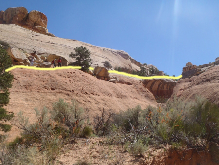
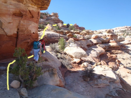
View into the bottom of The Betrothed. Yellow line shows route along the ledge on the east side of the Betrothed up to its head.
Lori, Jay and Abby shown as the beta models.
From the trail at the bottom of The Betrothed (wBetrothed-Bt),
walk up onto the reddish layer of slick rock on the left (east) side
of The Betrothed. Traverse up canyon along the reddish layer of
slick rock and make your way up to a ledge that transfers over to
the white layer and leads to the head of The Betrothed. On the way
along the ledge will be a couple spots of boulders to navigate
around or over. The head of The Betrothed is about 350 feet away
from the Cohab Canyon Trail.
From the head of the Betrothed (wBetrothed-Tp),
continue south up the drainage, climbing up a 5 foot up climb along
the way.
About 175 feet after the head of The Betrothed (wWivesTopRP-01) the
climb up the drainage will level off a little and you begin to get
views of the now more wide open area. It will no longer feel
like being in a drainage but rather topped out on a large wide open
shelf to the right (west) and a small wall still on your left.
When you are at this now wide open area turn right (south west) and start
walking up the gentle slope of white sandstone.
View along the shelf that leads over toward Wife 6. This is viewed from approximately wWivesTopRP-02 where you
first got to the large red patch in the slick rock.
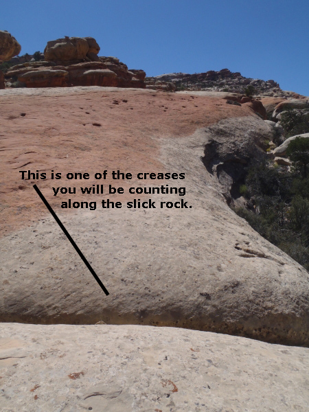
This is one of the creases you will be counting as you walk along the slick rock.
This first crease extends across the red and the white portion of
the shelf.
A little more than 200 feet along the white sandstone slope will be
a large red patch in the sandstone you are walking on
(wWivesTopRP-02). When you get to the large reddish patch on
the slick rock slope, take note of a few creases in the slick rock.
Counting these creases as you cross over them will be used to direct
you to the correct location for the top of Wife 6.
From
where first got to the reddish patch in the slick rock slope at
(wWivesTopRP-02), walk southwest and count the creases you cross
over along the way. The 1st will be about 35 feet away, the 2nd
will be another 150 feet, the 3rd is another 20 feet, the 4th
another 35 feet, the 5th and 6th creases run toward each other but
do not meet and are another 25 feet away and the 7th crease is
another 50 feet away.
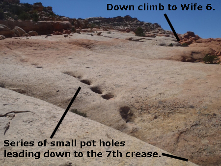
View of the series of
small pot holes leading down to the 7th crease. The series of
potholes is a visual clue to keep on track. The down climb to
Wife 6 is in the background.
Just after the 7th crease in the slick rock will be a series of
small potholes running down to meet the 7th crease. These potholes
are a visual clue to let you know you are at the 7th crease noted in
this route description. This visual cue may be helpful if you lose
count or followed a modified route up to this point.
After the series of small potholes running down to meet the 7th
crease will be the 8th crease about 60 feet beyond the potholes.
This 8th crease will be larger and require you to hop over it (or go
higher up to cross over its smaller head). This larger crease is
also a cue to being in the proper spot. This 8th crease is also the
marked as the junction to start over to Wife 6 (jWife6).
Leave Approach Route to go to Wife 6:
To break off from this approach route and continue down to Wife 6,
skip down to the description for Wife 6 in the Canyon / Technical
section.
To continue on the approach route
towards the other Wives, continue southwest along the slick rock.
About 250 feet along the slick rock and crossing a few more creases
the route will cliff out (jWife5). At this cliff out point you will
be overlooking a large convoluted system of slick rock drainages
below.
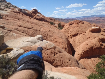
View down into the orange slick rock around the top of Wife 5.
The white knob is a good visual marker.
The large system of drainages below are the top of Wife 5 and
is all orange slick rock. In the center of this sea of orange slick
rock is a single white slick rock knob that is rounded and ball like
at the top. The crack running north down along the west side of
this white knob is the route down to Wife 5.
This cliff out point
(jWife5) where you can look down into the area above Wife 5, is
where you can break off to go to Wife 5.
Leave Approach Route to go to Wife 5
To break off from this approach route and continue down to Wife 5,
skip down to the description for Wife 5 in the Canyon / Technical
section.
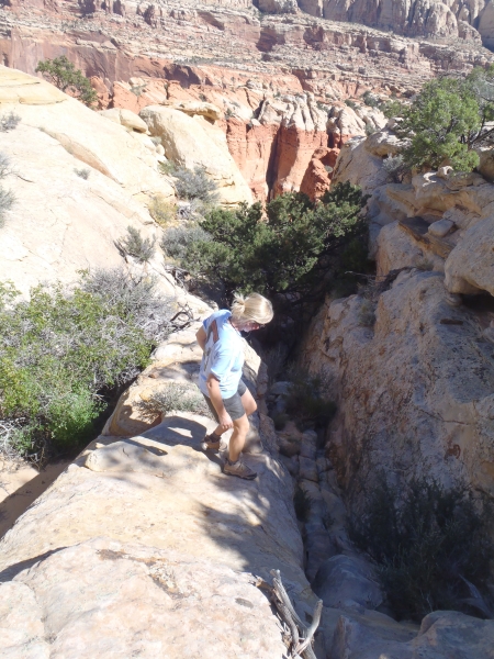
View of the route up to
and along the next higher shelf. Yellow line marks the
approximate route over toward Wife 4. Lori and Abby shown
as the beta models.
To
continue on the approach route towards the other Wives, walk about
75 feet southeast to find a spot to start scrambling up to the next
higher slick rock shelf (wWivesTopRP-03).
Continue about 330 feet
roughly southwest up and along this next higher shelf to a shady
alcove that is north facing and offers good shade most of the day
for taking a break (wWivesTopRP-04). On the wall in this alcove is
scratched USGS 1951 and 1953.
Continue west along the slick rock
and route find your way around fallen boulders and small drainages.
About 375 feet from the shady alcove the route will cliff out over
the upper section of Wife 4 (wWivesTopRP-05). This spot gives a
good view down into Wife 4.
From where you cliffed out looking
down over the upper section of Wife 4 (wWivesTopRP-05), turn left
(south) and walk up along the side of the drainage at the upper end
of Wife 4. After about 100 feet, the drainage will get shallow
enough to easily cross over it (yWife4Tp). This is the eastern most
of the two drainages that leads down to the top of Wife 4. This is
the top entry for Wife 4 and is where you can break off to descend
Wife 4.
View
down into the top entry for Wife 4. This is down the eastern
most of the two drainages at the top of Wife 4. Penny shown as the
beta model.
Leave Approach Route to go to Wife 4
To break off from this approach route and continue down to
Wife
4, skip down to the description for Wife 4 in the Canyon / Technical
section.
To continue on the approach route
towards the other Wives, walk west about 90 feet where you will
cross over another small drainage (wWivesTopRP-06). This small
drainage is the western most of the two drainages leading down to
the top of Wife 4.
Continue west and route find your way around
rock debris and small drainages. About 100 feet after crossing the
western most drainage to Wife 4, you will be able to break off to
descend Wife 3. Wife 3 is not visible from this approach
route. The head of Wife 3 is about 200 feet north of the
route.
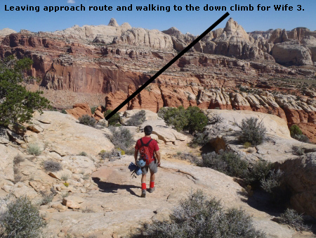
View of the walk over to
the down climb to Wife 3. Mike shown as the beta model.
Leave Approach Route to go to Wife 3
To break off from this approach route and continue down to Wife 3, skip down to the description for Wife 3 in the Canyon / Technical section.
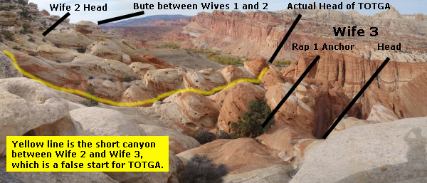
"View down to Wife 3, TOTGA and Wife 2. The yellow line
follows along the short canyon described as part of the approach
down to the actual head of TOTGA. As you can see from the
picture you could optionally follow the route down to the head of
Wife 3 then scramble over to the head of TOTGA.
To continue on the approach route towards the other Wives, walk west
about 90 feet where the route will cliff out overlooking a small
canyon. This canyon is a shorter canyon between Wife 3 and Wife 2
and is about 275 feet after leaving the western portion of the head
of Wife 4. This small canyon is also a false head of TOTGA.
If you get to this cliff out and are looking for the drop down to
Wife 3 you have went about 90 feet too far. Turn left (south) and walk along the edge of this
small canyon for about 150 feet to its head (jTOTGA). If you
are going to do the TOTGA route you will down climb into this small
canyon.
Leave Approach Route to go to TOTGA
To break off from this approach route and continue down to
TOTGA, walk over to the head of this small canyon
between Wife 2 and Wife 3 then skip down to the description for TOTGA in the Canyon / Technical
section.
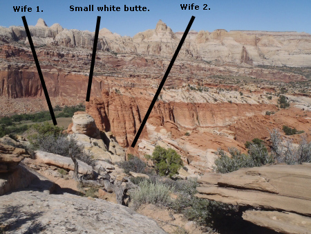
View of the white butte that divides Wife 1 and Wife 2.
To continue on the approach route towards Wives 1 and 2, continue west about 80 feet beyond the head of the short canyon.
Start looking for a small white butte about 100 feet to the right (north).
This butte is the divide between the start of Wife 2 and the start
of Wife 1.
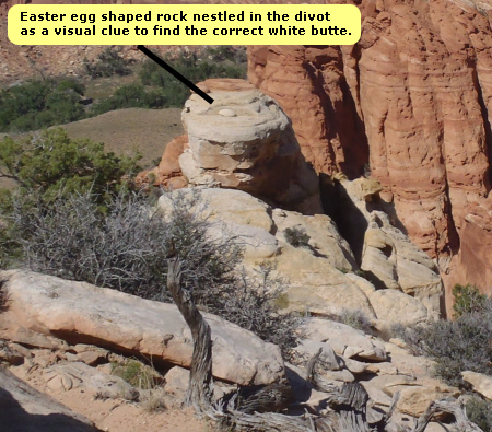
A closer view of the white butte. Look for that Easter egg
shaped rock as a visual clue for the correct butte.
As a visual cue you are looking at
the correct small butte look for a small Easter egg shaped rock
nestled in a divot near the top of the butte. Both the butte and
the Easter egg shaped rock are white sandstone.
Scramble about 120
feet down and north toward the small white butte. Wife 2 is down
along the right (east) side of the small white butte. Wife 1 is
down along the left (west) side of the small white butte.
Leave Approach Route to go to Wife 2
To break off from this approach route and continue down to
Wife 2,
skip down to the description for Wife 2 in the Canyon / Technical
section.
Leave Approach Route to go to Wife 1
To break off from this approach route and
continue down to Wife 1, skip down to the description for Wife 1 in
the Canyon / Technical section.
The Canyoneering / Technical Section:
Canyons listed in descending order since that is the order you
encounter them on the approach route along the top of the Wives.
Wife 6:
After crossing the 8th crease you are at the junction for Wife 6
(jWife6). This 8th crease leads down to the head of Wife 6, but you
will not follow down the crease. Instead you will bypass the drop
right at the head with a little bit of down climbing. The head of
Wife 6 (yWife6Tp) is marked at the sandy ledge about 60 feet to your
right at the bottom of the 8th crease you just crossed.
From the junction to Wife 6 (jWife6), look slightly right (west)
about 100 feet away to find a large rounded protrusion of orange
slick rock along the white slick rock rim. Between the orange slick
rock protrusion and the white rock of the shelf you are on is a down climb
(wWife6RP-01) to the level below you. You will need to drop down
into another crease and figure out how to get over onto the orange
slick rock.
Down climb and scramble about 30 feet down over some boulders. At
the bottom of the down climb are a bunch of large boulders. Work
your way through these and keep right. After clearing the boulders
walk down the slick rock about 125 feet northeast over to the RDC
wall. Along this wall will be a ledge along the top of a narrow
slot.
Rap 1 (dWife6-R1) is anchored along the white wall RDC from a medium
sized boulder about 15 feet back from the drop into a narrow slot.
Rap 1 is a two stage rap with stage one being about 40 feet down
into a narrow slot and stage 2 being about 15 feet. Total rope
travel for Rap 1 is about 80 feet. The first stage of rap 1 could
be down climbed at the head of the slot but the second part needs to
be rappelled so it is simpler to just rappel the whole thing. Be
careful not to twist your ropes on Rap 1 or you may have rope pull
issues.
Note!:
The anchor station for Rap 1 can easily be seen by those wondering
around in the area. It is a short easy route back up to Rap 1 after
descending Wife 6. After completing Wife 6, Please hike back up to
retrieve your anchor webbing to help keep the area clean for those
wondering around.
About 40 feet down canyon of rap 1 is a drop of about 8 feet that is
undercut. It can be down climbed with the last part being a
skip
down of a few feet. A partner assist would be nice here.
About 50
feet down canyon is another down climb of about 6 feet where a
partner assist is helpful but not a need.
Rap 2 (dWife6-R2) anchor is a large
bush in the canyon which has grown large enough to span from wall to
wall. Trying to get your anchor webbing tied to the base of this
bush will likely frustrate almost anyone attempting to do so while
you weave yourself into the bush to get to the base. The bush is
thick, scratchy and just difficult to get down into. Rap 2 drops
vertically about 80 feet if you rig your anchor webbing all the way
out to the down canyon end of the bush.
You will need about 25
feet of webbing to anchor Rap 2 to the base of the bush. The anchor
webbing should be extended all the way out to the down canyon end of
the bush. While walking (uh fighting) your way through the bush to
continue down canyon, be careful where you are stepping. The canyon
drops sharply at the end of the bush but seeing where the rock under
the bush ends is difficult so take your time and be careful.
After
rap 2 is a very narrow crack to stem over to continue down canyon.
While stemming over be careful where you place hands and feet on the
rock walls. There are a lot of huecos in the walls and the rock is
very brittle. After stemming over the crack get up onto the slick
rock on the LDC side then walk down to the top of rap 3.
Rap 3
(dWife6-R3) is about 85 feet down canyon of rap 2. At the top of
the drop just LDC of the crack is a large flake of rock that looks
like it could be used as an anchor. This is not suggested since the
rock is brittle and this flake might break and slide off while you
are on rappel.
To find the anchor for Rap 3, look down in the
crack RDC along the wall. There you will find a smaller crack with
a small choke stone in it as the anchor. The webbing tied to this
choke stone is dropped under and around a section of rock and
redirecting it down rap 3.
Rap 3 drops about 35 feet and has an
awkward start. You will need to leave extra rope to allow the rope
to follow the route down under the rock that is redirecting the
angle. Doing this will make it necessary to down climb the first
part of the rappel until the rope is weighted. At the bottom are a
couple boulders to scramble over. The area below rap 3 is a nice
place to relax and enjoy if you have the time.
After rap 3 it is
an easy walk of about 300 feet down canyon back to the Cohab Canyon
Trail to complete Wife 6 (yWife6Bt).
After completing Wife 6, please hike back up to retrieve the anchor
at rap 1. Then either do another Wife while up on top or hike back
to the Cohab Canyon Trail the way you came to exit.
Wife 5:
From where the route cliffed out
overlooking the area above Wife 5 (jWife5), walk about 125 feet
southwest over to a short down climb (wWife5RP-01). After down
climbing to the level of orange slick rock, traverse about 100 feet
up and around to the south side of the white knob. Then start down
the crack running north and down along the west side of the white
knob. The spot where the crack runs next to the west side of the
knob is marked as the head of Wife 5 (yWife5Tp).
From the head of
Wife 5 (yWife5Tp) continue north down climbing along the crack on
the west side of the white knob. At the bottom of the crack is a
sandy floor where the crack turns sharp right (east) and drops
another 10 feet to another ledge. This second ledge has a large
bush and is where the top of rap 1 is located.
Rap 1 (dWife5-R1)
is anchored from a large bush. The top of Rap 1 is sloped and rolls
off to a vertical rap of about 100 feet. Extend the anchor webbing
for the anchor about 10 feet from the bush to make this rap 100
feet. While on rap 1 you have take time to look over the alcove on
the way down. The rap is vertical with a couple awkward sections
going over slanted edges. Be careful to keep the ropes untwisted at
the top of rap 1. The sloped edge can cause a lot of friction
during the pull and any twists in the rope will create huge
problems.
At the bottom of rap 1 you are in a very closed in
section with winding twisting walls overhead and feels almost cave
like.
Rap 2 (dWife5-R2) is about 60 feet down canyon of rap 1.
Rap 2 drops about 35 feet along a series of drops in a tight slot.
The anchor is a choke stone a short distance down in the slot and
can make for an awkward start.
About 15 feet after rap 2 is a down climb of about 7 feet into a
water filled pot hole.
Rap 3
(dWife5-R3) is about 80 feet down canyon of rap 2. Rap 3 is
anchored from a dead man anchor and drops about 50 feet with a sharp
overhang near the top. The overhang is very sharp and undercut
leaving no place for your feet on the underside making it awkward.
There is a pool at the bottom to cross that is about thigh deep.
On the other side of the pool at the bottom of rap 3 are a couple of
down climbs. The first down climb is about 7 feet. A tall person
can lower their feet over belly first and grab a lip near the top to
let themselves over. Others will likely want a hand line. The
second down climb is a short drop to a small pool through a hole
that looks like a birthing canal.
Next are a couple of shallow
pools to cross on the way down canyon. The first pool can be
stemmed across by some and the second can be climbed around RDC by
some people as well. Most people will need to drop into and cross
these pools which are only a little over waist deep. The section
between rap 3 and 4 is a long straight section but has twisted walls
giving an interesting look.
Rap 4 (dWife5-R4) is almost 200 feet
down canyon of rap 3. Rap 4 drops about 60 feet over 2 stages and
starts down an awkward narrow slot. Rap 4 is awkward and is angled
such that the rope will rub harshly on sections of the rock and may
start to damage the rope. The rope position should be adjusted
between after each person raps to keep the rope from being damaged
by constant rubbing in the same place.
Rap 4 has an anchor
challenge. The original anchor used is a small choke stone in a
small hole near the top of the rap. The stone in the hole can be
next to impossible to get out even with a lot of work. If the
webbing is suspect it may be difficult or not possible to get the
rock out to replace the webbing. There are few other options for an
anchor here. There are few spots for a knot chock and the rock is
brittle making it risky. The rock in the area has very few features
and does not provide any obvious anchor options. A dead man anchor
is the best option here since there is a lot of sand. The issue
with this is there are few rocks here to use as the dead man. The
rocks that are there are brittle and may easily tear apart when
force is applied to them. The suggestion here is to go into the
canyon with something you intend to sacrifice as a dead man anchor.
Have someone haul in a rock, stick, old back pack or anything that
can be sacrificed as the dead man anchor. A SandTrap or MaxxiPad
may work well here as well.
After rap 4 is a long flat sandy
bottomed stretch with some vegetation growing on the sides. The
canyon here starts to widen out a little allowing more light in and
gives the impression you are almost out.
Rap 5 (dWife5-R5) is
about 125 feet down canyon of rap 4. Rap 5 is anchored from a dead
man in the sand and drops about 35 feet down a vertical wall. At
the bottom is a sandy bottomed grotto like area with a small tree
just down canyon of the rap. The spot at the bottom of rap 5 is
comfortable and would make a great picnic spot if hiking along the Cohab Canyon Trail since it is a short walk up the canyon to here
from the trail.
After rap 5 it is an easy walk about 250 feet down
canyon to the Cohab Canyon Trail where Wife 5 exits (yWife5Bt).
Once back out on the Cohab Canyon Trail you can conclude your day by
turning left (south) and following the Cohab Canyon Trail back to
the trailhead. Or you can turn right (east) to loop up and do
another Wife.
Wife 4:
From the top of the eastern drainage
leading down to Wife 4 (yWife4Tp) scramble down along the drainage
about 100 feet to the top of rap 1.
Rap 1 (dWife4-R1) is anchored
from a boulder about 10 feet back from the drop. You will need
about 30 feet of webbing to get around the boulder and string down
to the top of the rap. The anchor should be set so the rapid barely
hangs over the edge to help avoid rope pull issues. Rap 1 has an
awkward start as you drop over the edge. Once over the edge the rap
is free hanging most of the way as you descend down the middle of a
large alcove. Rap 1 drops about 75 feet to a sloped slick rock
floor.
After rap 1 the canyon is easy travel as it continues to
slope downward. A few down climbs along the way but most of what is
just after rap 1 is walking and light scrambling.
About 450 feet
down canyon of rap 1 is a drop with a boulder at the bottom
(wWife4RP-01). There is a ledge RDC of this drop that looks like it
may provide a bypass but does not. The easiest way down is to lean
out over the drop with the boulder right below you then get your
hands on the wall on the other side. This will have your feet on
one side and hands on the other forming a bridge. From there step
down onto the boulder.
After this is a short down climb where you
stem down into a narrow slot then crawl under a small pile of choke
stones.
About 70 feet farther down canyon is a tight crack to down
climb that is a total of about 50 feet tall. The slot is very
narrow and is easily stemmed or slithered down over two stages.
Near the bottom of the second stage it gets a little exposed feeling
but is easy to get down.
Just after the long skinny down climb is
another drop LDC. To get to the head of this drop where it is
possible to down climb, walk left around a fin and traverse the
ledge to the head of the drop. From there it is an easy down climb
of about 15 feet. Traversing out onto the ledge looks and feels
exposed. The ledge offers wide flat spots for your feet making this
a simple task, contrary to what your eyes first tell you.
Cohab
Canyon is about 200 feet down canyon from here and is an easy walk.
There will be one section where you will likely need to take your
pack off and walk sideways since the walls get tight.
Once back
out on the Cohab Canyon Trail (yWife4Bt) you can conclude your day
by turning left (south) and following the Cohab Canyon Trail back to
the trailhead. Or you can turn right (east) to loop up and do
another Wife.
Wife 3:
About 100 feet after crossing the western
most of the two drainages down to Wife 4 turn right (north) and look
for a natural place to down climb near a Pinyon Pine tree juniper tree (jWife3).
The down climb is about 35 feet down a boulder. At the bottom of
the down climb you will see a small rock shaped like and anvil. At
the bottom of the down climb continue north along the slick rock
slope.
Looking north down the slick rock you will see a sandy
ledge about 140 feet away. To the right (east) of the sandy ledge
will be a large Pinyon Pine which will be the anchor for the rap
down into Wife 3. Find your way down the slick rock and to the
large pine.
Rap 1 (yWife3Tp) drops down on the west side of the head of wife 3.
Rap 1 is from the large pine and drops down into the head of Wife 3
on its LDC side. You should use about 60 feet of webbing for the
anchor. This will allow the anchor to be extended from the tree
over to the top of the rap and down the slope a ways to avoid rope
pull issues from excessive drag. The top of Rap 1 rolls off as a
gentle slope at the top then quickly goes vertical and into free
hang. Rap 1 drops 200 feet with a lot of free hang on the way
down. The rope will need to travel longer than 200 feet if the
webbing for the anchor is left too short.
It is recommended to rig the anchor for rap 1 and drop your 200 foot
rope with no pull cord. Leave the anchor webbing and your single
200 foot rope in place. Use a shorter rope to complete the canyon.
After completing Wife 3, hike back to the top and retrieve the rope
and anchor webbing. This will alleviate the need to haul the 200
foot rope through the canyon and allow you to clean up the unsightly
webbing anchor at the top. Since you are up there to clean up the
webbing you might as well use the rope as an excuse to do another
Wife. Wife 3 then Wife 5 make a great combination for a day and
should be considered in this order.
While at the bottom of rap 1, be sure to stay out of the
way of things that might fall. There is loose rock along the top
that can easily be knocked off as other rap down to you. If
providing a fireman belay for someone, there is a small alcove at
the head where you can get out of the way while doing so. Others
should stay on the east side of the canyon, where there is a better
view of the rap anyway. Staying out of the way here will keep you
from getting hit on the head with the occasional falling of rocks or
stray backpacks.
After rap 1 scramble down the slick rock slope LDC until you come to
a narrow crack that needs to be down climbed. The crack is about 15
feet tall and is a fun excursion to down climb. This down climb is
optional and can easily be bypassed down a slope RDC. Although
this is an optional down climb, it might be a good idea to down
climb the crack since it will provide a good warm up for the
mandatory down climb shortly down canyon.
About 200 feet down canyon of rap 1 is another narrow
crack. This one needs to be down climbed. The narrow crack drops
about 35 feet and has very rough walls which will tear you up if you
are not careful. This one should be put in the carnivorous
category. This down climb may present a challenge to some. A top
rope is a god idea here for those not comfortable with this style of
down climbing. Part way down the down climb you drop under a choke
stone. While doing so, take time to look into the small arch on the
RDC side of the down climb.
After this down climb is a long flat
sandy bottomed corridor about 350 feet long. If you like long
narrow corridor areas in canyons take it slow here to enjoy it
beauty and peacefulness. At the end of the corridor the canyon
looks as though it comes to a dead end.
At the end of the corridor
the canyon makes a hard left and presents a drop of about 40 feet.
This drop is rap 2.
Rap 2 (dWife3-R2) is anchored from a rock jug
handle formed from one of the holes or huecos in the canyon wall on
the RDC side. The rope is extended to the LDC side of the canyon to
the top of rap 1. Rap 2 drops about 40 feet down a vertical wall.
While going over the edge of rap 2, be careful of rope placement.
The top of rap 2 is awkward and can place the rope in a position to
slide and become damaged.
Other options for the anchor to rap 2 are slim. The walls are very
featured but brittle making most options from the wall not a good
idea. There are also a few places where knot chocks would fit but
the rock is also too fragile for this. A crack on the RDC wall
about 30 feet up canyon of the rap can provide a good spot for a
choke stone anchor if you can find a rock that is not too fragile.
The other option here would be a dead man anchor. If building a
dead man anchor, the rocks used would need to be farmed from up
canyon since there are few rocks in the sand here.
Down canyon of rap 2 is another narrow corridor of
about 125 feet. At the end of the corridor is rap 3.
Rap 3
(dWife3-R3) is a 2 stage optional rap that drops over two stages
where the canyon makes a left turn. The stages are about 12 feet
each and can be down climbed by experienced down climbers. If you
decide to rap the 2 stage rap 3, it can be anchored from a choke
stone in a crack near the top of the rap.
Optionally and
recommended is to bypass rap 3. To bypass rap 3 climb up about 15
feet along the RDC wall at the top of rap 3. After climbing up walk
over the rounded slick rock to a narrow chimney down climb along the
RDC wall. A belay should be set for those not comfortable with this
style of down climbing. The chimney down climb is about 30 feet.
The bottom of rap 3 is about 70 feet from the Cohab Canyon Trail.
At the bottom of rap 3 it is a short scramble along the slick rock
on the RDC side of the canyon to get back onto the Cohab Canyon
Trail (yWife3Bt).
Once back out on the Cohab Canyon Trail you can
conclude your day by turning left (south) and following the Cohab
Canyon Trail back to the trailhead. Or you can turn right (east) to
loop up and do another Wife.
TOTGA:
The small canyon between Wife 2 and Wife 3 is a false start to TOTGA
and is actually a side drainage down to Wife 3. When you reach
the head of the small canyon between Wife 3 and Wife 2 (jTOTGA) down
climb into this small canyon with a down climb of about 30 feet.
The down climb is not difficult but be careful since there is a lot
of loose brittle rock here.
After the down climb, is a gentle slope and some stuff to scramble down
along rock fall debris to a flat sandy floor. about 150 feet later
the canyon get narrow with walls about 7 feet apart. This
narrow section travels straight for almost 200 feet with a sandy
floor before turning sharply right (east).
When the narrow section turns right do not follow it. Instead
climb up the crevice directly in front of you which is sloped and an
easy up climb of about 30 feet. When you reach the top of the
climb (yTOGAtp) you will be able to look down the true head of
TOTGA, which is just a little over 500 feet from the floor of Cohab
Canyon.
Note:
If you had followed the small canyon to the right at the end of it's
narrows you will come to a pour over dropping down into the side of
Wife 3.
Also of note is that the head of TOTGA is a short distance from the
head of Wife 3. So optionally you could use the approach over
to Wife 3. When you get to the big tree used as the anchor for
rap 1 in Wife 3 follow the short slot over toward TOTGA. This
would avoid the small short canyon and the down climb at the head of
it when leaving the trail for the route already described.
Start down the true head of TOTGA by down climbing
about 50 feet down a narrow slot to the floor below. This
first down climb has a lot of loose chossy rock so be careful with
every move. Actually a lot of this canyon is loose and chossy
so take care all the way through.
When you get to the bottom of the down climb you will be in a
chamber like section with subway like walls on each side.
Looking down canyon almost feels like being in a tunnel.
Continue down canyon along a semi steep sloped floor. About
150 feet down canyon after the first down climb is another drop.
By pass this drop by climbing up and over the rock on the RDC side
to get to another narrow chimney down climb. Getting up and
over to this second down climb involves a little exposure. The
down climb on the other side is about 40 feet over a couple stages
while going under a choke stone. While on this second down
climb be quiet and hope the evil clown that lives there does not
sneak up behind you. After this second down climb you are only
about 350 feet from the end of TOTGA where it empties into Cohab
Canyon.
Continue down canyon between semi narrow walls for a hundred
feet or so to the start of another narrow down climb. This
down climb is the narrowest down climb in the canyon. You will
need to take your pack off to get past a few spots along this down
climb. This down climb has a lot of loose brittle rock as well
making this a good time to remind yourself to watch where you put
those feet and hands.
At the bottom of the long narrow down climb is a small ledge large
enough for 2 people (kind of tight). From this ledge it is
another short down climb to get to the canyon floor in a section
that is a little wider. The down climb down from the small
ledge is about 15 feet and drops into a cave like area where people
frequently climb up to from the bottom of the canyon. The down
climb from the ledge into the cave is a difficult one. Most
people will want a belay from the top. Save your better down
climber to give the belay and down climb this last. Even the
skilled down climber in your group may wish they had a belay.
The down climb starts out skinny then quickly bells out leaving very
little to get feet or hands onto on the LDC wall. Someone at
the bottom can climb up part way and assist with giving the last
person a spot.
Walk through the cave then drop down another short down climb
before walking out to the end of the canyon (yTOGAbt) where it meets Cohab
Canyon.
Once back out on the Cohab Canyon Trail you can conclude your day by
turning left (south) and following the Cohab Canyon Trail back to
the trailhead. Or you can turn right (east) to loop up and do
another Wife.
Wife 2:
The head of
Wife 2 (yWife2Tp) starts down the right (east) side of the small white butte.
Scramble down the slot to along the east side of the butte. About
100 feet down canyon will be the top of rap 1.
Rap 1 (dWife2-R1)
is anchored from a choke stone anchor in a crack about 20 feet back
from the rap. Near the top of rap 1 is a short down climb of about
6 feet to a small sandy ledge. Extend the anchor webbing down to
the sandy ledge to keep rope pull issues to a minimum. There are
places where a knot chock anchor could work but the rock is too
brittle for this to be trusted. There are also a few protrusions of
rock that could be used as anchors but again the rock is too brittle
for this to be trusted.
Rap 1 drops 100 feet down a mostly
vertical section of wall with a gentle slope down near the bottom.
The slope at the bottom allows the rope to be done with a little
less than 100 feet of rope travel. At the bottom of rap 1 is a down
climb of about 15 feet down a narrow slot.
Rap 2 (dWife2-R2) is
about 100 feet down canyon of rap 1. Rap 2 is anchored from a large
rock knob RDC and drops about 40 feet. Rap 2 can optionally be
bypassed via a down climb LDC along a section of rock with a lot of huecos. With the rock being brittle it may be safer to rap than to
down climb. The anchor webbing will not be seen by casual hikers
from the top or bottom so using the rap option at this drop will not
noticeably dirty the canyon.
About 50 feet down canyon of rap 2 is
a drop of about 40 feet. The drop can be bypassed by climbing down
along a series of ledges RDC.
Shortly down canyon is a tight slot
to stem down into with a large choke stone in it. Stem down under
the choke stone about 15 feet then stem down canyon in the slot to
another section to stem down another 15 feet.
About 150 feet down
canyon after the narrow slot down climb is a down climb of about 8
feet. Then a walk of a couple hundred feet down canyon with some
easy scrambles along the way before reaching the rap 3 which is the
final rap.
Rap 3 is the final rap and is right at the exit of Wife
2 (yWife2Bt). From the top of rap 3 take time to look across Cohab
Canyon at the Wife Beaters side. There is an interesting slab of
rock that makes you wonder how it fell into that position high up on
the wall.
Rap 3 is anchored from a dead man anchor with more rocks
on top making it at combo of a dead man and a cairn anchor. Rap 3
drops about 85 feet along a vertical wall. To avoid rope pull
issues the anchor webbing should be extended just over the edge of
the rap. This will make it necessary to stem down the first part of
the rap until you are low enough to weight the rope. This may be
awkward for some but makes the rope pull simple and free of pinch
points.
After getting to the bottom of rap 3, walk up a dirt slope
about 20 feet to find yourself back on the Cohab Canyon Trail.
Once back out on the Cohab Canyon Trail you can conclude your day by
turning left (south) and following the Cohab Canyon Trail back to
the trailhead. Or you can turn right (east) to loop up and do
another Wife.
Wife 1:
The head of
Wife 1 (yWife1Tp) starts down the left (west) side of
the small white butte with the Easter egg on it. Right at the
head of the canyon is a skinny chimney down climb of about 35 feet.
At the bottom of the down climb you are in what feels like a small
cave. At the exit of the cave like area on the down canyon
side is a great view out toward Cohab Canyon.
Just after exiting the cave like portion below the first down climb
you will have a down climb of 15 to 20 feet over a few large
boulders and will still be between narrow walls. Rap 1 is at
the bottom of the boulders you climb down after the cave.
Rap 1 is anchored from one of the boulders you down climbed and
drops about 20 feet down a mostly vertical wall. Rap 1 might
be down climbed by stemming between the walls and chimneying down.
Getting to the LDC wall would involve a very sketchy lean out to
reach the LDC. There are also foot holds that may aid in
getting stretched across the drop as well.
After rap 1 stem down canyon a few feet then drop down another
chimney style down climb of about 25 feet. This down climb
drops down onto a large ledge with views of the more wide open
spaces of Wife 1. It also becomes obvious that this route is
working down a crack and ledge system along the RDC side of the
canyon. On the down canyon end of the ledge after the down
climb is another drop down between narrow walls which is rap 2.
Rap 2 is anchored from a choke stone in a crack LDC along the ledge
about 15 feet back from the top of Rap 2. To find the anchor
walk over to the top of the drop then look back about 15 feet along
the ledge LDC of the down climb. Set the anchor from a choke
stone in the crack and run the webbing along the crack down to the
top of the rap. Rap 2 drops about 25 feet down a slope and is
down easily down climbable except for the last 8 to 10 feet.
Rap 3
(dWife1-R1-3) is the final rap in Wife 1 and is anchored a few feet from the bottom of rap 2. The top
of the drop for Rap 3 however is about 20 feet down a slope from the
anchor. The webbing should be extended from the choke stone
down the slope and over to the edge of the drop. The natural
fall line of Rap 3 falls left over the ledge rather than straight
down canyon. If the anchor webbing is not extended all the way
down to the ledge there may be difficulties in pulling the ropes
after the rappel. Other issues will be increased wear on both
rock and ropes. With the anchor webbing extended down to the
top of the ledge Rap 3 drops about 60 feet down from the ledge to
the canyon floor with free hanging rappel for a little more than
half of it.
The slope from the anchor to the ledge at the top of rap 3 can be
down climbed pretty easily but can be a bit un-nerving for some
since you will be down climbing to the top of the drop off.
For those not comfortable with this you can set up a separate rope
to lower them down the down climb. For each person to be
lowered you will need to pull the end of the anchor webbing up to
the top of the slope, set them up on the rappel rope ready to go.
Then lower them with a separate rope until the rappel rope is
weighted at which time they can lock off the rappel line and detach
from the lower line. The last person down can use the anchor
webbing as a hand line while down climbing the slope.
At the bottom of rap 3 you find yourself in the now much wider main
canyon of Wife 1 and about 400 feet from the lower end of Wife 1
where it meets Cohab Canyon. Before heading down canyon after
rap 3 walk over to the end of the ledge on the LDC side of the
canyon to look down on some interesting rock features.
To continue down canyon after rap 3 scramble down the slope on the
RDC side of the canyon. Down canyon of rap 3 will be a slot on
the LDC side you will need to down climb. Getting into the
slot will require a climb down the side of it over a section of rock
with a lot of thin brittle sections. Be very careful what you
step on while getting over into the slot. The down climb down
the slot is about 20 feet and a very easy almost scramble.
From the bottom of the slotted scramble walk a short distance along
a flat sandy bottomed hall way section for about 90 feet. At the other end of
this hallway like section will be a more narrow area to the right
with a drop shortly after in a very narrow slot. The best
route out is not to go down this slot. Instead climb up a
crevice on the LDC side about 15 to 20 feet high. At the top
of the crevice walk down canyon along slick rock and look for a way
to drop into a narrow area on the RDC side of the canyon where you
can scramble or walk a short distance to the end of the canyon
(yWife1Bt).
Once back out on the Cohab Canyon Trail you can conclude your day by
turning left (south) and following the Cohab Canyon Trail back to
the trailhead. Or you can turn right (east) to loop up and do
another Wife.
The Exit:
After getting back to the Cohab Canyon Trail after any one of the
wives, turn left (west) and hike the Cohab Trial less than 1 mile
back to the trailhead where you began.
Downloadable GPX files
available at
BG-Gear Store
(easier than manual entry and a great way to support
Bluugnome).
Waypoint naming convention and map symbol information can be found on the Glossary page.
Elevations are approximate.
BEFORE
manually entering coordinates set your system to WGS84 datum and Lat/Lon hddd.ddddd° coordinate format.
Inconsistent datum's and coordinate formats will result in location errors.
Click to show / expand the list of waypoints below........
| Wives (a) - Drive to Trailhead |
- vCapReefVisit
Lat/Lon (WGS84): N 38.29111
W -111.26180
Elev: 5,208 Feet
Capitol Reef Visitor Center.
- pkShadyPark
Lat/Lon (WGS84): N 38.28528
W -111.24628
Elev: NaN Feet
Parking area at a large beautiful picnic area.
FYI there is a water spiggot at the base of a water fountain here to fill up on water.
- pkGiffordFarm
Lat/Lon (WGS84): N 38.28409
W -111.24701
Elev: 5,394 Feet
Small parking lot by the Gifford Farm house store.
- pkCohab
Lat/Lon (WGS84): N 38.28337
W -111.24643
Elev: 5,423 Feet
Parking for about 3 vehicles next to a small hay barn along the road. About 260 feet from the Cohab Canyon trailhead.
- tCohab
Lat/Lon (WGS84): N 38.28264
W -111.24619
Elev: 5,450 Feet
Cohab Canyon Trailhead.
|
| Wives (b) - Approach (along all 7 canyon tops) |
- tCohab
Lat/Lon (WGS84): N 38.28264
W -111.24619
Elev: 5,450 Feet
Cohab Canyon Trailhead.
- wCohabRP-01
Lat/Lon (WGS84): N 38.28275
W -111.24372
Elev: 5,730 Feet
Top of the switch backs at the start of Cohab Canyon.
- wCohabRP-02
Lat/Lon (WGS84): N 38.28098
W -111.24386
Elev: 5,790 Feet
Western end of Cohab Canyon.
- yWife1Bt
Lat/Lon (WGS84): N 38.28106
W -111.24353
Elev: 5,800 Feet
Bottom Exit of Wife 1 where it meets the Cohab Canyon Trail.
- yWife2Bt
Lat/Lon (WGS84): N 38.28122
W -111.24319
Elev: 5,795 Feet
Bottom Exit of Wife 2 where it meets the Cohab Canyon Trail. Wife 2 is not visible from the Cohab Canyon Trail. There is a rappel of 85 feet here to exit the canyon to the trail. The anchor fro this rap is a dead man anchor and webbing should be set long to avoid rope pull issues.
- yTOGAbt
Lat/Lon (WGS84): N 38.28154
W -111.24272
Elev: 5,790 Feet
Bottom Exit of TOTGA (The One That Got Away) where it meets the Cohab Canyon Trail.
- yWife3Bt
Lat/Lon (WGS84): N 38.28170
W -111.24205
Elev: 5,780 Feet
Bottom Exit of Wife 3 where it meets the Cohab Canyon Trail.
- yWife4Bt
Lat/Lon (WGS84): N 38.28189
W -111.24162
Elev: 5,770 Feet
Bottom Exit of Wife 4 where it meets the Cohab Canyon Trail. As a land mark There is a sign posted along the trail here telling you to stay on the trails.
- yWife5Bt
Lat/Lon (WGS84): N 38.28239
W -111.24033
Elev: 5,750 Feet
Bottom Exit of Wife 5 where it meets the Cohab Canyon Trail. A walk of about 250 feet up canyon will get you to the bottom of rap 5 and a great spot to stop for a picnic if only hiking in the area.
- yWife6Bt
Lat/Lon (WGS84): N 38.28267
W -111.23935
Elev: 5,730 Feet
Bottom Exit of Wife 6 where it meets the Cohab Canyon Trail.
- wBetrothed-Bt
Lat/Lon (WGS84): N 38.28319
W -111.23786
Elev: 5,720 Feet
Bottom of The Betrothed. Travel up a ledge on the left (east) side of The Betrothed to access the tops of the Wives. Stay on slickrock to avoid destroying crypto.
- wBetrothed-Tp
Lat/Lon (WGS84): N 38.28234
W -111.23789
Elev: NaN Feet
Top of The Betrothed. This is not something you will want to descend. From the top, turn west and start up out of the wash you find yourself in by walking up the slick rock.
- wWivesTopRP-01
Lat/Lon (WGS84): N 38.28188
W -111.23784
Elev: NaN Feet
Climb up the drainage above the head of The Betrothed starts to level off. There are now views over the now more wide open areas.
- wWivesTopRP-02
Lat/Lon (WGS84): N 38.28139
W -111.23832
Elev: 5,880 Feet
The beginning of a large section of orange sandstone along the route up from The Betrothed.
- jWife6
Lat/Lon (WGS84): N 38.28068
W -111.23957
Elev: 5,970 Feet
After crossing the 8th crease in the slickrock here you can choose to continue on the approach to the other Wives or break off to go to Wife 6.
To go to Wife 6, look about 100 feet to the east for an orange rounded section of slick rock along the white slick rock rim. Between the white and orange slick rock will be a couple small pines and is the route of the down climb to the ledge below.
- jWife5
Lat/Lon (WGS84): N 38.28037
W -111.24037
Elev: 6,000 Feet
As you are traveling southwest the route will cliff out here and will be overlooking the complex system of slick rock drainages at the top of Wife 5.
- wWivesTopRP-03
Lat/Lon (WGS84): N 38.28025
W -111.24026
Elev: NaN Feet
Start scrambling up to the next higher ledge to traverse over toward Wife 4.
- wWivesTopRP-04
Lat/Lon (WGS84): N 38.27946
W -111.24078
Elev: NaN Feet
North facing alcove that provides shade almost all day and makes a good rest spot. In the wall of the alcove is scratched USGS 1951 and 1953.
- wWivesTopRP-05
Lat/Lon (WGS84): N 38.27920
W -111.24193
Elev: NaN Feet
Route runs along the eastern edge of Wife 4 and gives a great view down into Wife 4.
- yWife4Tp
Lat/Lon (WGS84): N 38.27891
W -111.24212
Elev: 6,170 Feet
Top of Wife 4. This is at the shallow upper end of the drainage leading down into Wife 4. This is the eastern most of the two short drainages leading down into Wife 4.
- wWivesTopRP-06
Lat/Lon (WGS84): N 38.27898
W -111.24239
Elev: NaN Feet
Crossing over the western drainage that leads down to Wife 4. This is not the drainage down to rap 1. To descend Wife 4 drop down the eastern drainage.
- jWife3
Lat/Lon (WGS84): N 38.27925
W -111.24272
Elev: 6,160 Feet
Top of a down climb of about 35 feet next to a small juniper. At the bottom of the boulder down climb is a small rock that looks like an anvil.
- jTOTGA
Lat/Lon (WGS84): N 38.27885
W -111.24325
Elev: 6,230 Feet
Head of a short side slot between Wife 3 and Wife 2. This is the head of a very small canyon leading down to the head of TOTGA.
- yWife2Tp
Lat/Lon (WGS84): N 38.27928
W -111.24340
Elev: 6,200 Feet
Top of Wife 2. This is to the right (east) of a small white butte.
- yWife1Tp
Lat/Lon (WGS84): N 38.27942
W -111.24354
Elev: 6,190 Feet
Top of Wife 1. This is to the left (west) of a small white butte.
|
| Wives (c) - The Canyon, Wife 1 |
- yWife1Tp
Lat/Lon (WGS84): N 38.27942
W -111.24354
Elev: 6,190 Feet
Top of Wife 1. This is to the left (west) of a small white butte.
- dWife1-R1-3
Lat/Lon (WGS84): N 38.27995
W -111.24356
Elev: NaN Feet
Raps 1 thru 3 - Wife 1. This point marked aprox where rap 3 is located.
Rap 1 anchored from a large boulder and drops about 20 feet down a vertical wall in a narrow slot.
Rap 2 anchored from about 15 feet back and drops about 25 feet.
Rap 3 anchored from a small choke stone with webbing extended about 20 feet tot eh drop and drops about 60 feet over a ledge with freehang.
- yWife1Bt
Lat/Lon (WGS84): N 38.28106
W -111.24353
Elev: 5,800 Feet
Bottom Exit of Wife 1 where it meets the Cohab Canyon Trail.
|
| Wives (d) - The Canyon, Wife 2 |
- yWife2Tp
Lat/Lon (WGS84): N 38.27928
W -111.24340
Elev: 6,200 Feet
Top of Wife 2. This is to the right (east) of a small white butte.
- dWife2-R1
Lat/Lon (WGS84): N 38.27957
W -111.24329
Elev: NaN Feet
Rap 1 - Wife 2. Anchored from a choke stone about 20 feet back from the rap and drops about 100 feet.
- dWife2-R2
Lat/Lon (WGS84): N 38.27988
W -111.24325
Elev: NaN Feet
Rap 2 - Wife 2. Anchored RDC from large rock knob and drops about 40 feet. Rap 2 can optionally be down climbed LDC along a very brittle section with a lot of huecos.
- yWife2Bt
Lat/Lon (WGS84): N 38.28122
W -111.24319
Elev: 5,795 Feet
Bottom Exit of Wife 2 where it meets the Cohab Canyon Trail. Wife 2 is not visible from the Cohab Canyon Trail. There is a rappel of 85 feet here to exit the canyon to the trail. The anchor fro this rap is a dead man anchor and webbing should be set long to avoid rope pull issues.
|
| Wives (e) - The Canyon, TOTGA |
- jTOTGA
Lat/Lon (WGS84): N 38.27885
W -111.24325
Elev: 6,230 Feet
Head of a short side slot between Wife 3 and Wife 2. This is the head of a very small canyon leading down to the head of TOTGA.
- yTOGAtp
Lat/Lon (WGS84): N 38.28008
W -111.24295
Elev: NaN Feet
Top entry for TOTGA. This is the true top of TOTGA.
- yTOGAbt
Lat/Lon (WGS84): N 38.28154
W -111.24272
Elev: 5,790 Feet
Bottom Exit of TOTGA (The One That Got Away) where it meets the Cohab Canyon Trail.
|
| Wives (f) - The Canyon, Wife 3 |
- jWife3
Lat/Lon (WGS84): N 38.27925
W -111.24272
Elev: 6,160 Feet
Top of a down climb of about 35 feet next to a small juniper. At the bottom of the boulder down climb is a small rock that looks like an anvil.
- yWife3Tp
Lat/Lon (WGS84): N 38.27969
W -111.24275
Elev: 6,105 Feet
Top entry for Wife 3. This is on the east side of the head of the canyon and is also the location for rap 1 down into Wife 3. Rap 1 - Wife 3. Anchored from a large Ponderosa Pine. Set the anchor webbing about 60 feet long over to the edge of the rap to keep rope drag to a minimum on the pull.
- dWife3-R2
Lat/Lon (WGS84): N 38.28119
W -111.24221
Elev: NaN Feet
Rap 2 - Wife 3. Anchored from a rock jug handle formed by some of the holes on the RDC wall. Rap 2 drops about 40 feet on the LDC side of the canyon down a vertical wall.
- dWife3-R3
Lat/Lon (WGS84): N 38.28155
W -111.24217
Elev: NaN Feet
Rap 3 - Wife 3. Optional rap that can be anchored from a choke stone in a crack RDC of the drop. The rap is a two stage rap that can be down climbed by experienced down climbers. The stages are about 12 feet each. Optionally rap 3 can be bypassed with a climb up and over RDC and down a narrow chimney down climb of about 40 feet.
- yWife3Bt
Lat/Lon (WGS84): N 38.28170
W -111.24205
Elev: 5,780 Feet
Bottom Exit of Wife 3 where it meets the Cohab Canyon Trail.
|
| Wives (g) - The Canyon, Wife 4 |
- yWife4Tp
Lat/Lon (WGS84): N 38.27891
W -111.24212
Elev: 6,170 Feet
Top of Wife 4. This is at the shallow upper end of the drainage leading down into Wife 4. This is the eastern most of the two short drainages leading down into Wife 4.
- dWife4-R1
Lat/Lon (WGS84): N 38.27923
W -111.24206
Elev: 6,110 Feet
Rap 1 - Wife 4. Anchored from a boulder about 10 feet back and drops about 75 feet and is mostly free hanging.
- wWife4RP-01
Lat/Lon (WGS84): N 38.28041
W -111.24195
Elev: NaN Feet
A drop with a large boulder at the bottom.
- yWife4Bt
Lat/Lon (WGS84): N 38.28189
W -111.24162
Elev: 5,770 Feet
Bottom Exit of Wife 4 where it meets the Cohab Canyon Trail. As a land mark There is a sign posted along the trail here telling you to stay on the trails.
|
| Wives (h) - The Canyon, Wife 5 |
- jWife5
Lat/Lon (WGS84): N 38.28037
W -111.24037
Elev: 6,000 Feet
As you are traveling southwest the route will cliff out here and will be overlooking the complex system of slick rock drainages at the top of Wife 5.
- wWife5RP-01
Lat/Lon (WGS84): N 38.28009
W -111.24063
Elev: NaN Feet
A down climb in a small drainage to drop down to the level where the white knob is.
- yWife5Tp
Lat/Lon (WGS84): N 38.28011
W -111.24099
Elev: 6,020 Feet
Top of Wife 5. This point is slightly west of a round white knob surrounded by a sea of red slick rock.
- dWife5-R1
Lat/Lon (WGS84): N 38.28039
W -111.24088
Elev: NaN Feet
Rap 1 - Wife 5. Anchored from a nice big bush. Extend the webbing about 10 feet or more from the bush so the rope travel is only 100 feet. Rap 1 drops about 100 feet with a couple awkward slanted ledges along the way is is mostly vertical.
- dWife5-R2
Lat/Lon (WGS84): N 38.28058
W -111.24076
Elev: NaN Feet
Rap 2 - Wife 5. Anchored from a choke stone and drops about 35 feet along a series of drops in a tight crack.
- dWife5-R3
Lat/Lon (WGS84): N 38.28084
W -111.24064
Elev: NaN Feet
Rap 3 - Wife 5. Anchored from a dead man anchor and drops about 50 feet to a pool about thigh deep. Near the top of rap 3 is an overhang that is awkward to get over.
- dWife5-R4
Lat/Lon (WGS84): N 38.28134
W -111.24054
Elev: NaN Feet
Rap 4 - Wife 5. Anchored from a choke stone down in a hole at the top or optionally a dead man can be used in the sand. It is recommended to bring in something to sacrifice as the dead man for this rap. Rap 4 drops about 60 feet over 2 stages starting in an awkward start.
- dWife5-R5
Lat/Lon (WGS84): N 38.28171
W -111.24042
Elev: NaN Feet
Rap 5 - Wife 5. Anchored from a dead man and drops about 35 feet.
- yWife5Bt
Lat/Lon (WGS84): N 38.28239
W -111.24033
Elev: 5,750 Feet
Bottom Exit of Wife 5 where it meets the Cohab Canyon Trail. A walk of about 250 feet up canyon will get you to the bottom of rap 5 and a great spot to stop for a picnic if only hiking in the area.
|
| Wives (i) - The Canyon, Wife 6 |
- jWife6
Lat/Lon (WGS84): N 38.28068
W -111.23957
Elev: 5,970 Feet
After crossing the 8th crease in the slickrock here you can choose to continue on the approach to the other Wives or break off to go to Wife 6.
To go to Wife 6, look about 100 feet to the east for an orange rounded section of slick rock along the white slick rock rim. Between the white and orange slick rock will be a couple small pines and is the route of the down climb to the ledge below.
- wWife6RP-01
Lat/Lon (WGS84): N 38.28075
W -111.23990
Elev: NaN Feet
Start of the down climb to get down into Wife 6. Look for an orange section of slickrock next to the white slick rock ledge you are on. Down climb between these two to get to the level below.
- yWife6Tp
Lat/Lon (WGS84): N 38.28088
W -111.23962
Elev: 5,960 Feet
Top of Wife 6. The head of the canyon starts here at a flat sandy ledge just down from the slickrock ledge above. To descend the Canyon, bypass this ledge by working around the west side then below here to get to rap 1.
- dWife6-R1
Lat/Lon (WGS84): N 38.28106
W -111.23971
Elev: 5,900 Feet
Rap 1 - Wife 6. Anchored RDC along a wall from a medium boulder about 20 feet back from the side of a narrow slot. Rap 1 is a two stage rap. Stage 1 about 40 feet, stage 2 about 15 feet and total rope travel of 80 feet.
- dWife6-R2
Lat/Lon (WGS84): N 38.28161
W -111.23967
Elev: NaN Feet
Rap 2 - Wife 6. Anchored from a large bush spanning between the canyon walls and drops about 80 feet.
- dWife6-R3
Lat/Lon (WGS84): N 38.28185
W -111.23964
Elev: NaN Feet
Rap 3 - Wife 6. Anchored from a small choke stone in a crack that is down under where you are standing and drops about 35 feet.
- yWife6Bt
Lat/Lon (WGS84): N 38.28267
W -111.23935
Elev: 5,730 Feet
Bottom Exit of Wife 6 where it meets the Cohab Canyon Trail.
|