Canyoneering Route Description
Na-gah fork of Shinob Canyon - 3A(B) I
Capitol Reef National Park, Utah.
05-28-11, 5 people, 1 Day (Travel time in route 7.5 hours) Time
includes the side trip up to Fern's Nipple.

Time Required - 3 to 4 hours for Na-gah only -
add about 3 hours if also doing the Fern's Nipple side trip.
Distance - 2.3 miles Total, 0.4 miles Technical
- add 2.4 miles if also doing the Fern's Nipple side trip.
Rappels - 3 Rappels, Longest Rappel 155 feet.
Elevation Range - 5390 - 6040 Feet (max
elevation will be 7065 if also doing the Fern's Nipple side
trip).
Shuttle Required -No Vehicle - Passenger
Permit Required - Yes
Rappelling and anchor gear, Ropes and or pull cords for rappels up
to 155 feet and 40 feet of 1 inch webbing for sling placement.
Warning?
Rumor has it that someone has been
removing bolts in Capitol Reef
National Park! This may affect
this route if bolts are removed
here. Be prepared to get
creative if you find the bolts have
been removed.
The Na-gah fork of
Shinob Canyon is the northernmost
fork. Na-gah offers some fun
down climbs, a nice chamber like
section and scenic fun rap to end
the route down into main Shinob.
The Shinobs are a
collection of routes in the forks of
Shinob Canyon. The routes were
shared with me by the same friend that
shared the Wives. I enjoy the
same spirit of sharing as she does,
so here they are. Just like the Wives, these
canyons are all fairly short
routes. A side trip up to Fern's
Nipple is a convenient way to add a
little length and variety to the
routes.
The Name Shinob Canyon does not show on most maps. The
Shinob name was found on a map distributed by the Capitol Reef Visitor
center. The forks of Shinob Canyon are being called by names from the
Piute legends surrounding the Piute god Shinob. The northernmost fork
goes by the name Na-Gah, the middle fork goes by the name Timpie and the
southernmost fork goes by the name Nighthawk. The Piute name for
Nighthawk is Y-bru-sats. Y-bru-sats was thought to be a little
difficult to commit to memory so the English translation of is used,
Nighthawk.
Note - Map Reading Warning:
Different maps have Bear Canyon labeled in different locations. I
thought it a good idea to mention this to help clear up any possible
confusion.
The route up to the Shinobs and Ferns Nipple
uses a side canyon off of Grand Wash to gain access to the area above
Shinob Canyon. This side canyon is labeled as Bear Canyon on the
National Geographic maps and has no name on Garmin's Mapsource maps.
Garmin's Mapsource maps labels a small canyon about 0.2 miles east as
Bear Canyon.
The canyon referred to here as Bear Canyon is
the one labeled as Bear Canyon on National Geographic maps and un-named
in Garmin maps. Keep in mind if you are using Garmin software or maps
you will see Bear Canyon labeled about 0.2 miles east of the canyon
referred to here as Bear Canyon.
Note:
The Fern's Nipple side trip - - - The side trip route up to Fern's
Nipple will add additional time and mileage if you decide to go up
there. Well worth the views if you take the time.
Allow 2 to 4 additional hours for the side trip
up to Fern's Nipple. Time will depend on the speed of the group and
what fork of Shinob you plan to do. The additional distance for the
side trip to Fern's Nipple will also depend on the fork of Shinob you
set out to do and will be between 0.8 to 2.4 miles. Fern's Nipple will
also take the highest elevation for the route to 7065 feet.
It is recommended to take a length of webbing or
rope to the top of Fern's Nipple to assist each other with sketchy parts
of the route down from the top of Fern's Nipple.
To get to the Trailhead
Start from the turn off of highway 24 to the Capitol Reef
Visitor Center. This is about 9.7 miles north on highway 24
from the town of Torrey, Utah, which is at the junction of
highways 12 and 24.
From the turn off to the Capitol Reef Visitor Center (vCapReefVisit)
follow the Scenic Drive road about 3.4 miles southeast to the
turn off for Grand Wash (extGrandWash).
Turn left (east) onto the dirt road to Grand Wash (extGrandWash).
Drive 1.3 miles to the end of the road where it ends at the
Grand Wash and Cassidy Arch trailhead (tGrandWash).
To leave the Exit Vehicle / Escape Pod
No exit vehicle is needed. This is done as a loop route.
GPS coordinate information listed at the bottom. For information about waypoint naming and map symbols, refer to the
Glossary page.

Click the links for maps of the route.
Map of the
entire route.
Map of the
approach section.
Map of the
Na-gah and Timpie forks.
Map of the
Nighthawk fork and Fern's Nipple side trip.
The Approach:
From the Grand Wash
trailhead (tGrandWash),
walk east down the trail
along Grand Wash.
About 0.2 miles after
leaving the parking area
will be the junction for
the start of the Cassidy
Canyon trail on the left
(tCassidy). Continue
past the Cassidy Canyon
junction.
About 375 feet after the
Cassidy Canyon junction
is where you will start
the route up out of
Grand Wash (jBearCyn).
This point is about 175
feet south of a point on
the right (east) side of
the wash you have been
walking in.
Note:
The route up out of
Grand Wash will traverse
the ledge system on the
right (east) side of the
wash. From the point
where you leave Grand
Wash (jBearCyn), you
will ascend and traverse
along the ledge system
going up and south
toward Bear Canyon.
Note:
Different maps have Bear
Canyon labeled in
different locations. I
thought it a good idea
to mention this to help
clear up any possible
confusion. For more
information see the note
about this in the
general comments
section.
While walking in Grand
Wash, keep an eye on the
cliff band on the right
(east). About 175 feet
before reaching what
looks like the end of
the cliff band as it
goes around a corner is
where you will start the
hike up out of the wash
(jBearCyn). Look for an
easy scramble up onto a
series of ledges running
along the cliff band.
Parts of the route along
the ledges are cairned
but the cairns are small
and can easily go
un-noticed.
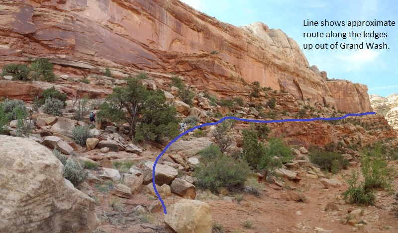
The blue line shows the approximate route along the ledges up out of Grand Wash. Around the point at the end of the blue line is Bear Canyon.
After scrambling up
about 50 feet or so to a
ledge veer right (south)
and travel along the
ledge. About 600 feet
along the ledge look for
an easy scramble up to
the next highest ledge
(wBearRP-01). After
getting up to the next
highest ledge
(wBearRP-01) continue
south along that ledge.
About 400 feet farther
will be an up climb
(wBearRP-02) of about 15
feet to get to the next
highest ledge. The up
climb has plenty of hand
holds and spots for your
feet making it an easy
chore. After getting to
the top of the up climb,
continue south along the
next highest ledge.
About 150 feet farther
the ledges will come to
a wide flat area
(wBearRP-03) on the
ledge as it rounds the
corner to the left
(south east). From this
flat area the ledge
continues south east up
the left (north east)
side of Bear Canyon.
There are good views
down to the Grand Wash
trailhead and over to
Cassidy Arch from here.
Walking along the ledge
on the side of Bear
Canyon offers some good
views since you are high
up on a cliff band.
About 450 feet after
starting along the ledge
on the side of Bear
Canyon you will find a
spot where you can
easily cross over Bear
Canyon along the top of
a slick rock pour off
(wBearRP-04).
Note:
Optionally from the pour
off you could continue
up Bear Canyon about 300
feet to a 15 foot up
climb. Then continue
another 300 feet up Bear
Canyon to a dry fall of
about 30 feet (sBearDryFall).
The dry fall can be
up climbed directly or
up a chute on the left
(south) both of which
are a little sketchy.
After climbing up the
dry fall you can
traverse west back down
canyon along the south
side of Bear canyon and
work your way over to
intersect with the
standard route at point
(wShinobRP-04).
Cross over Bear Canyon
along the top of the
slick rock pour off
(wBearRP-04) and
continue south west
scrambling up to the
shelf on the other side
of Bear Canyon.
Contour southwest along
the shelf for about 300
feet to where a cairned
route starts
(wShinobRP-01). There
are multiple cairned
routes running up along
here so follow what
feels good to you at the
time.
Note:
The cairned route you
are following will lead
to the base of the
pointed rock out
cropping peak but will
not take a direct
route. Keep this in
mind and resist the urge
to go directly toward
the pointy peak.
The route up will travel
a little up into that
ravine, cross over to
the right (north) side
of the ravine then go
farther up into the
ravine where you will
then traverse back
across the ravine along
the bottom side of a
vertical wall (under an
arch) to just under the
outcropping peak you
just noted.
As you follow the
cairned route look ahead
to the southwest and
note a pointed rock
outcropping like peak.
Note a large bowl like
ravine to the right
(north) of the peak.
Follow the cairned route
up into the ravine.
After about 250 feet the
cairned route crosses
over to the north side
of the bowl like ravine
(wShinobRP-02).
Shortly after crossing
over the ravine will be
the start of a use trail
traveling up the ravine
on the north side.
As you continue up the
north side of the
ravine, stay on the
lookout for an arch in
the ravine with a
vertical wall below it.
Then look for a way to
walk over to a ledge
that traverses under the
arch at the base of the
vertical wall back over
to the south side of the
ravine.
As you traverse along
the ledge under the arch
(wShinobRP-03) continue
along the ledge and
follow it about 200 feet
east out to a point.
Then continue around the
point about 50 feet and
look for the bottom of a
chute (wShinobRP-04).
Scramble up the chute
about 40 or 50 feet to a
small landing. Turn
left on the landing and
scramble up another
chute that will top out
in another 30 or 40 feet
(wShinobRP-05).
After getting to the top
of the chutes
(wShinobRP-05), you will
be greeted with slightly
more wide open feeling
spaces. Travel west
along the slick rock
skirting around a bowl
and out to a point about
500 feet from the top
out of the climb up the
chutes. From the point
you will begin to have
good views west over
toward Cassidy Arch.
Walk around the point
(wShinobRP-06) and
continue along the now
very wide ledge to the
south. Shortly after
getting around the
point, look for a well
worn trail starting
through the dirt heading
south and slowly veering
to the south east.
About 0.2 miles along
the dirt trail, you will
transition from a white
dirt and sandstone and
crossing over a red
patch of rock
(wShinobRP-07). The
large canyon system to
the right (south west)
is Shinob Canyon. Also
this is where you start
to get good view of
Fern's Nipple in the
distance.
About 500 feet after
crossing the red area of
dirt and sandstone you
will find the head of a
drainage on the right
(west) which is the top
of the Na-gah fork of
Shinob Canyon (yNa-gahTp).
To drop down the
Na-gah fork of Shinob,
jump to the technical
section below for the
Na-gah fork of Shinob
Canyon.
To continue to
the Timpie or Nighthawk
fork of Shinob Canyon or
to Fern's Nipple,
continue with this
approach description.
From the head of the Na-gah
Fork of Shinob (yNa-gahTp),
contour around the head
of the canyon to the
south west. About 350
feet farther the route
will cross over a small
drainage
(wShinobRP-08). This
small drainage is an
optional drop in for the
fork of the Shinobs you
just passed). After
crossing over the small
drainage, the route
climbs a little while it
continues to follow a
wide large ledge.
About 0.25 miles farther
the route will go around
a point (wShinobRP-09).
From this point you get
good views over toward
the main portions of
Shinob Canyon and a good
view of Fern's Nipple in
the distance. Also
around this point you
will begin to find a
well worn trail going
through the dirt and
slick rock.
About 0.2 miles farther
the route will cross
over a part of the ledge
with a very large
undercut under it
(wShinobRP-10).
About 360 feet after the
undercut ledge, will be
the top of another
drainage which is the
drop in for the Timpie
fork of Shinob Canyon.
Just before getting to
down to the drainage the
route will traverse
across a section of
steep soft sand with a
significant drop down
it. On the other side
of the sand slope you
will be down in the
drainage for the Timpie
fork of Shinob Canyon (yTimpieTp).
To drop down the
Timpie fork of Shinob
Canyon, refer
to the route description
for the Timpie fork of
Shinob Canyon.
To continue to
the Nighthawk fork of
Shinob Canyon or to
Fern's Nipple,
continue with this
approach description.
From the Timpie fork of
Shinob Canyon (yTimpieTp),
continue across the
drainage and up the
other side. The route
will go west then
gradually veer south.
About 300 feet after
crossing the top of the
second fork of Shinob
Canyon, you will need to
start scrambling up a
series of easy sections
(wShinobRP-11) to work
up toward the next
higher level. The
scrambling continues
intermittently for a
little over 200 feet
before meeting up with a
well defined use trail
(wShinobRP-12). This
use trail continues to
climb and is in mostly
white dirt and
sandstone.
After about 400 feet the
use trail tops out and
goes around a point
(wShinobRP-13). This is
also where the trail
starts to travel through
more red dirt and
sandstone rather than
the white you were on.
After going around the
point (wShinobRP-13) the
route starts to descend
again. Follow the use
trial along a ledge for
about 500 feet to where
it crosses over a the
Nighthawk fork of Shinob
Canyon (yNitHwkTp).
This is the top entry
for the Nighthawk fork
of Shinob Canyon.
To drop down the
Nighthawk fork of Shinob
Canyon, refer
to the route description
for the Nighthawk fork
of Shinob Canyon.
To do the side
trip to Fern's Nipple,
refer to the side trip
portion of the approach
route.
The Side Trips:
Side trip
to Fern's Nipple: From
the head of the
Nighthawk fork of Shinob
(yNitHwkTp), go up
south up stream in the
drainage and scramble up
a rock fall debris
area. About 100 feet up
canyon will be a dry
fall of about 12 feet
(wFernNipRP-01). The
climb up the dry fall is
moderately difficult and
feels exposed.
After getting to the top
of the dry fall the
drainage has a subtle
fork. Continue up the
right (southwest) fork.
Continue up the drainage
about 250 feet then
start to look for a
convenient place to
climb out
(wFernNipRP-02).
About 200 feet farther
the route up out of the
drainage tops out
briefly (wFernNipRP-03)
and a cairned route
should be fairly easy to
find here.
After the route levels
off for a moment work
south up the hill aiming
for Fern's Nipple which
should be easy to spot
here. About 150 feet up
the hill will be a
section of sandstone to
scramble and up and over
(wFernNipRP-04).
Shortly after getting up
and over this section
you will be greeted with
a great un-obstructed
view of Fern's Nipple
about 1000 feet away.
About 400 feet farther
will be a flat sandy
area near the base of
the final slope up to
Fern's Nipple
(wFernNipRP-05). From
the flat sandy area
route find the route
that feels the most
comfortable up the slick
rock slope toward Fern's
Nipple.
About 350 feet up the
slope will be a
transition to a much
steeper grade of close
to 45 degrees
(wFernNipRP-06). From
here it is only about
400 feet to the top of
Fern's Nipple and you
will need to route find
your own way up. The
last 50 feet or so
before reaching the top
gets very steep and will
feel very exposed, so
take care here. The
easiest side to go up is
the west side of Fern's
Nipple.
The top of Fern's Nipple
(p-Ferns-Nipple) has a
log book to sign so
enjoy! The views here
are great and if weather
allows makes a great
spot for a snack and to
just take in the views.
Reverse the route to get
back down to the Shinob
Canyon route. Take care
getting down the first
few feet from Fern's
Nipple. You will likely
need to help each other
to get down safely. A
length of webbing can be
helpful for this.
The Canyoneering / Technical Section:
Na-gah
fork of Shinob Canyon:
From the head of the Na-gah
fork (yNa-gahTp), travel
southwest down the wash
leaving the approach
route. As you start
down the drainage there
will be a short section
of sloped slick rock to
scramble down about 10
feet.
About 150 feet down
canyon will be a drop of
about 50 feet down a
series of slick rock
ledges (wNa-gahRP-01).
This drop is easily
bypassed by on the left
(south) side by walking
about 80 feet over to
find an easy down climb
down into a side wash
then continuing down
canyon. When walking
over to the bypass, try
to stay off of any
crypto biotic soil.
Continue about 450 feet
down the sandy wash to
the top of another drop
of about 100 feet
(wNa-gahRP-02). This
drop is also easily
bypassed by walking
about 100 feet LDC
(south) to a chute that
allows you to scramble
back down to the wash
floor. Please try to
stay off the crypto
biotic soil here as
well.
About 200 feet down
canyon will be a third
drop in the canyon
(wNa-gahRP-03). This
drop is about 40 feet
and can be down climbed
over a series of
ledges. Staying
slightly RDC on the way
down provides a
relatively easy path
down the ledges. This
drop can optionally be
bypassed by hiking
around LDC (south) about
150 feet then down a
slope to the canyon
floor.
After getting down the
series of ledges along
the 40 foot drop, walk
down canyon about 50
feet to another drop of
about 20 feet. This
fourth drop is bypassed
by hiking about 50 feet
around the LDC side and
scrambling down the
broken slick rock.
A little over 100 feet
down canyon is the top
of a drop down into a
narrow slot with a
twisted tree growing at
the top of the drop
(wNa-gahRP-04). Start
down the down climb by
squeezing down under the
twisted tree and
chimneying down the
narrow slot. The
chimney is about 20 feet
down to the wash below.
About 20 feet down
canyon is another drop
of about 15 feet down to
some boulder debris.
The 15 foot down climb
is difficult near the
bottom due to the walls
flaring out and having
little to grab. Here it
is recommended to have a
good down climber go
last and provide a hand
line for everyone else.
Optionally there is some
boulder debris just up
canyon that a hand line
can be rigged from if no
one in the group feels
confident about the down
climb.
Continue down canyon
over the boulder debris
in the now narrow
canyon. The canyon here
is narrow and V shaped
for about 30 feet making
it necessary to stem
down canyon rather than
walk. After the 30 foot
stemming section, you
will drop down to a
sandy bottom floor to
walk on.
The sandy floor section
is about 150 feet long
with a down climb in the
middle of it about 12 to
15 feet. The down climb
is stem style and only
moderately difficult.
Rap1 (dNa-gahR1) is
bolted RDC from two
bolted hangers about
chest high. Rap 1 drops
about 60 feet down a
narrow section into a
dark chamber like area
with a pool at the
bottom. The pool at the
bottom could be about
waist deep or a little
more if the canyon was
full. On the other side
of the pool walk down
the narrow canyon about
60 or 70 feet to a ledge
where you will find rap
2.
Rap 2 (dNa-gahR2) is
about 70 feet down
canyon of rap 1 and
drops about 35 feet.
When you get to the
ledge, walk out along
the top of the ledge to
the right about 10 feet
to get over to the
anchors. The anchors
for rap 2 are two bolted
hangers on the ledge
down at foot level.
Rap 3 (dNa-gahR3) is
about 40 feet down
canyon of rap 2. Rap 3
is bolted LDC from two
bolted anchors about
chest high. Rap 3 drops
about 155 feet down a
mostly vertical wall
along a winding crack
into the main Shinob
Canyon. Rap 3 is wide
open with great views so
take time to enjoy it.
At the bottom of rap 3
you are in the main
Shinob Canyon drainage
and are done with the
technical portion of the
route (yNa-gahBt).
The Exit:
Once in
the main drainage for
Shinob Canyon (yNa-gahBt),
turn right (north) and
walk down the large wide
open canyon.
About 0.3 miles down
canyon will be the end
of the Shinob Canyon
where it dumps into
Grand Wash and meets the
road that goes into the
Grand Wash Trailhead.
Turn right (north east)
and follow the road
about 0.3 miles back to
the Grand Wash Trailhead
(tGrandWash).
Downloadable GPX files
available at
BG-Gear Store
(easier than manual entry and a great way to support
Bluugnome).
Waypoint naming convention and map symbol information can be found on the Glossary page.
Elevations are approximate.
BEFORE
manually entering coordinates set your system to WGS84 datum and Lat/Lon hddd.ddddd° coordinate format.
Inconsistent datum's and coordinate formats will result in location errors.
Click to show / expand the list of waypoints below........
| Shinob 1 - Drive to Trailhead |
- extGrandWash
Lat/Lon (WGS84): N 38.25622
W -111.23287
Elev: 5,580 Feet
Exit off of the scenic drive to a dirt road into Grand Wash.
- tGrandWash
Lat/Lon (WGS84): N 38.26373
W -111.21570
Elev: 5,425 Feet
Parking area at the Grand Wash trailhead.
|
| Shinob 2 - Approach (along all three canyon tops) |
- tGrandWash
Lat/Lon (WGS84): N 38.26373
W -111.21570
Elev: 5,425 Feet
Parking area at the Grand Wash trailhead.
- tCassidy
Lat/Lon (WGS84): N 38.26586
W -111.21350
Elev: 5,390 Feet
Junction out of Grand Wash for the trailhead to Cassidy Canyon.
- jBearCyn
Lat/Lon (WGS84): N 38.26678
W -111.21316
Elev: 5,400 Feet
This is where the route up to Bear Canyon leaves Grand Wash and starts up the side of the cliff band.
Note: Bear Canyon is labbled as the canyon just east of here on Garmin maps and the canyon just west of hear on National Geographic maps. The one just south west of here is being referred to as Bear Canyon for this route.
- wBearRP-01
Lat/Lon (WGS84): N 38.26514
W -111.21321
Elev: NaN Feet
Look for an easy scramble up to the next highet ledge then continue south along the ledges on the cliff band.
- wBearRP-02
Lat/Lon (WGS84): N 38.26414
W -111.21354
Elev: NaN Feet
Up climb of about 15 feet to get to the next higher ledge. After getting to the top of the up climb, continue south along the ledges.
- wBearRP-03
Lat/Lon (WGS84): N 38.26376
W -111.21385
Elev: 5,560 Feet
The ledges up out of Grand Wsh lead go around a corner here and follow along the north east side of BearCanyon on a wide ledge.
- wBearRP-04
Lat/Lon (WGS84): N 38.26280
W -111.21282
Elev: NaN Feet
Ledge along the side of Bear Canyon gets to a spot where you can easily cross over Bear Canyon along the top of a slick rock pour off.
- wShinobRP-01
Lat/Lon (WGS84): N 38.26249
W -111.21373
Elev: NaN Feet
Start of a cairned route. This area has a few ways you can go with enough cairns that you will eventually start to follow a cairned route no matter which way you travel.
- wShinobRP-02
Lat/Lon (WGS84): N 38.26208
W -111.21443
Elev: 5,760 Feet
Cairned route crosses over the ravine then starts to travel up the north side of it.
- wShinobRP-03
Lat/Lon (WGS84): N 38.26185
W -111.21475
Elev: 5,860 Feet
Ledge traversing under an arch along a ledge at the base of a vertical wall.
- wShinobRP-04
Lat/Lon (WGS84): N 38.26183
W -111.21413
Elev: 5,820 Feet
Start of a scramble up a chute to get up above the ledge you have been on.
- wShinobRP-05
Lat/Lon (WGS84): N 38.26159
W -111.21450
Elev: 5,885 Feet
Top out of the climb up the chutes from the ledge below. Continue west to follow the Shinob route.
- wShinobRP-06
Lat/Lon (WGS84): N 38.26141
W -111.21614
Elev: 5,970 Feet
This is where the route goes around a point then follows a wide ledge to teh south.
- wShinobRP-07
Lat/Lon (WGS84): N 38.25906
W -111.21492
Elev: NaN Feet
Crossing over a red patch of dirt and sandstone as opposed to the white dirt and sandstone you have been on so far.
- yNa-gahTp
Lat/Lon (WGS84): N 38.25845
W -111.21350
Elev: 5,940 Feet
Top entry for the Na-gah Fork of Shinob Canyon.
- wShinobRP-08
Lat/Lon (WGS84): N 38.25756
W -111.21344
Elev: NaN Feet
Route crosses over a small drainage which is and optional drop in for the fork of the Shinobs you just passed.
- wShinobRP-09
Lat/Lon (WGS84): N 38.25594
W -111.21587
Elev: 6,160 Feet
Route goes around a point and presents great views of the main portions of Shinob Canyon and Fern's Nipple.
- wShinobRP-10
Lat/Lon (WGS84): N 38.25466
W -111.21334
Elev: NaN Feet
Route along the ledge crosses over a section of the ledge with a big undercut under it.
- yTimpieTp
Lat/Lon (WGS84): N 38.25397
W -111.21275
Elev: 6,055 Feet
Top entry for the Timpie Fork of Shinob Canyon.
- wShinobRP-11
Lat/Lon (WGS84): N 38.25408
W -111.21381
Elev: NaN Feet
Start to climb up a series of scrambles to get up to the next higher leve to the south.
- wShinobRP-12
Lat/Lon (WGS84): N 38.25365
W -111.21435
Elev: NaN Feet
Start of a well worn use trail.
- wShinobRP-13
Lat/Lon (WGS84): N 38.25278
W -111.21523
Elev: 6,210 Feet
Use trail tops out here and goes around a point. The trail here is also in red dirt and sandstone as opposed to the white dirt you were traveling in.
- yNitHwkTp
Lat/Lon (WGS84): N 38.25172
W -111.21447
Elev: 6,240 Feet
Top entry of the Nighthawk Fork of Shinob Canyon.
|
| Shinob 3 - The Canyon, Na-Gah |
- yNa-gahTp
Lat/Lon (WGS84): N 38.25845
W -111.21350
Elev: 5,940 Feet
Top entry for the Na-gah Fork of Shinob Canyon.
- wNa-gahRP-01
Lat/Lon (WGS84): N 38.25826
W -111.21394
Elev: NaN Feet
Drop of about 50 feet in the wash that is esily bypassed LDC by walking about 80 feet south to find an easy donw clinb into a side wash.
- wNa-gahRP-02
Lat/Lon (WGS84): N 38.25833
W -111.21566
Elev: NaN Feet
Top of a drop of about 100 feet. This drop is also easily bypassed by walking about 100 feet left (south) to the top of a chute that allows a scramble down to the canyon floor.
- wNa-gahRP-03
Lat/Lon (WGS84): N 38.25845
W -111.21638
Elev: 5,785 Feet
The third drop in the canyon and is about 40 feet. Down climb a series of ledges here staying slightly RDC to get down this drop.
This drop can optionally be bypassed by hiking about 150 feet to the left (south) then down a slope to the canyon floor.
- wNa-gahRP-04
Lat/Lon (WGS84): N 38.25855
W -111.21679
Elev: NaN Feet
Top of a narrow slot to down climb with a twisted tree at the top of it. The drop under the tree down the slot is about 20 feet to the wash below.
- dNa-gahR1
Lat/Lon (WGS84): N 38.25878
W -111.21758
Elev: NaN Feet
Rap 1 - Na-gah Fork Shinob. Anchored RDC about chest high from two bolted hangers and drops about 60 feet in a chamber with a pool at the bottom that could get up to about waist deep.
- dNa-gahR2
Lat/Lon (WGS84): N 38.25885
W -111.21783
Elev: NaN Feet
Rap 2 - Na-gah Fork Shinob. Anchored from two bolted hangers at foot level on a ledge and drops about 35 feet.
- dNa-gahR3
Lat/Lon (WGS84): N 38.25893
W -111.21798
Elev: NaN Feet
Rap 3 - Na-gah Fork Shinob. Anchored from two bolted hangers about chest high LDC and drops about 155 feet down a mostly vertical wall into the main drainage for Shinob Canyon.
- yNa-gahBt
Lat/Lon (WGS84): N 38.25907
W -111.21834
Elev: 5,520 Feet
Bottom of the Na-gah fork of Shinob Canyon where it meets the wash in the main portion of Shinob Canyon.
|
| Shinob 4 - The Canyon, Timpie |
- yTimpieTp
Lat/Lon (WGS84): N 38.25397
W -111.21275
Elev: 6,055 Feet
Top entry for the Timpie Fork of Shinob Canyon.
- wTimpieRP-01
Lat/Lon (WGS84): N 38.25415
W -111.21300
Elev: 6,060 Feet
Drop of about 30 feet. Scramble down the drop to the last 6 feet which can be awkward but is a down climb.
- dTimpieR1
Lat/Lon (WGS84): N 38.25443
W -111.21389
Elev: 5,905 Feet
Rap 1 - Timpie fork of Shinob Canyon. Can be anchored from a treeup above the drop on the RDC side or a knot chalk on the LDC side. Rap 1 drops about 15 feet. If using knot chalks be careful of rock quality.
- wTimpieRP-02
Lat/Lon (WGS84): N 38.25452
W -111.21535
Elev: 5,871 Feet
Top of a large drop that is bypassed by scrambling around LDC about 125 feet then down to below the shelf.
- dTimpieR2
Lat/Lon (WGS84): N 38.25452
W -111.21553
Elev: 5,900 Feet
Rap 2 - Timpie fork of Shinob Canyon (the big rap). Rap 2 is anchored from a rock near the top of the drop and drops a total of about 275 feet. The last 50 feet of the rap are down climbable so a shorter rope can be used.
- dTimpieR3
Lat/Lon (WGS84): N 38.25449
W -111.21585
Elev: NaN Feet
Rap 3 - Timpie fork of Shinob Canyon. Anchored from a pinch point between a boulder and the canyon wall and drops about 20 feet. Possibly down climable but may be a bit sketchy.
- yNitHwkbt
Lat/Lon (WGS84): N 38.25464
W -111.21708
Elev: NaN Feet
Rap 6 - Nighthawk fork Shinob Canyon and the end of the Nighthawk fork. At the bottom of the rap you are now in the Timpie fork. Anchored from a deadman and drops right at 200 feet if the anchor webbing was extended far enough. A slightly longer than 200 foot rope is recomended.
- dTimpieR4
Lat/Lon (WGS84): N 38.25476
W -111.21722
Elev: NaN Feet
Rap 4 - Timpie fork Shinob Canyon. On the RDC side of a ledge andchored from a tree root and a bolt and drops about 30 feet. There is a piton part way down the rap.
- yTimpieBt
Lat/Lon (WGS84): N 38.25535
W -111.21824
Elev: 5,520 Feet
Bottom exit of the Timpie fork of Shinob where it meets the main Shinob Canyon.
|
| Shinob 5 - The Canyon, Nighthawk |
- yNitHwkTp
Lat/Lon (WGS84): N 38.25172
W -111.21447
Elev: 6,240 Feet
Top entry of the Nighthawk Fork of Shinob Canyon.
- dNitHwkR1
Lat/Lon (WGS84): N 38.25208
W -111.21491
Elev: 6,107 Feet
Rap 1 - Nighthawk fork of Shinob Canyon. Anchored from a tree about 20 feet back and drops about 80 feet down a slightly sloped wall.
- dNitHwkR2
Lat/Lon (WGS84): N 38.25233
W -111.21568
Elev: NaN Feet
Rap 2 - Nighthawk fork of Shinob. Anchored from a tree on a ledge on the RDC side. Drops about 60 feet down a series of ledges.
- wNitHwkRP-01
Lat/Lon (WGS84): N 38.25255
W -111.21627
Elev: 6,016 Feet
Drop of about 20 feet. Bypassable Rdc or LDC.
- dNitHwkR3
Lat/Lon (WGS84): N 38.25288
W -111.21671
Elev: 5,960 Feet
Rap 3 - Nighthawk Fork of Shinob Canyon. Anchored from a tree or a boulder about 20 feet back and drops about 80 feet down a sloped wall with about 30 feet of free hang mid way down.
- dNitHwkR4
Lat/Lon (WGS84): N 38.25391
W -111.21703
Elev: 1 Feet
Rap 4 - Nighthawk fork of Shinob Canyon. This is between potholes 14 and 15 and drops down into pothole 14. Anchored from a bush about 15 feet back and drops about 12 feet.
- dNitHwkR5
Lat/Lon (WGS84): N 38.25405
W -111.21704
Elev: 5,822 Feet
Rap 5 - Nighthawk fork of Shinob Canyon. This is between potholes 15 and 16 and drops down into pothole 16. Anchored from log wedged in the water course at the top of the drop. Rap 5 drops about 40 feet with the first 15 feet being down climbable.
- yNitHwkbt
Lat/Lon (WGS84): N 38.25464
W -111.21708
Elev: NaN Feet
Rap 6 - Nighthawk fork Shinob Canyon and the end of the Nighthawk fork. At the bottom of the rap you are now in the Timpie fork. Anchored from a deadman and drops right at 200 feet if the anchor webbing was extended far enough. A slightly longer than 200 foot rope is recomended.
- dTimpieR4
Lat/Lon (WGS84): N 38.25476
W -111.21722
Elev: NaN Feet
Rap 4 - Timpie fork Shinob Canyon. On the RDC side of a ledge andchored from a tree root and a bolt and drops about 30 feet. There is a piton part way down the rap.
- yTimpieBt
Lat/Lon (WGS84): N 38.25535
W -111.21824
Elev: 5,520 Feet
Bottom exit of the Timpie fork of Shinob where it meets the main Shinob Canyon.
|
| Shinob 6 - Exit |
- yTimpieBt
Lat/Lon (WGS84): N 38.25535
W -111.21824
Elev: 5,520 Feet
Bottom exit of the Timpie fork of Shinob where it meets the main Shinob Canyon.
- yNa-gahBt
Lat/Lon (WGS84): N 38.25907
W -111.21834
Elev: 5,520 Feet
Bottom of the Na-gah fork of Shinob Canyon where it meets the wash in the main portion of Shinob Canyon.
- tGrandWash
Lat/Lon (WGS84): N 38.26373
W -111.21570
Elev: 5,425 Feet
Parking area at the Grand Wash trailhead.
|
| Shinob 7 - Side Trip to Ferns Nipple |
- yNitHwkTp
Lat/Lon (WGS84): N 38.25172
W -111.21447
Elev: 6,240 Feet
Top entry of the Nighthawk Fork of Shinob Canyon.
- wFernNipRP-01
Lat/Lon (WGS84): N 38.25143
W -111.21413
Elev: NaN Feet
Dry fall of about 12 feet that needs to be up climbed. There are a couple routes to climb up this.
- wFernNipRP-02
Lat/Lon (WGS84): N 38.25075
W -111.21429
Elev: NaN Feet
Start to climb out the right (southwest) side of the drainage here and look for a cairned route.
- wFernNipRP-03
Lat/Lon (WGS84): N 38.25052
W -111.21488
Elev: 6,480 Feet
Climb up out of the drainage tops out briefly and a cairned route should be fairly easy to find here.
- wFernNipRP-04
Lat/Lon (WGS84): N 38.24997
W -111.21520
Elev: NaN Feet
Section of sandstone to climb or scramble up. Go slight left of the point here.
- wFernNipRP-05
Lat/Lon (WGS84): N 38.24927
W -111.21410
Elev: 6,690 Feet
Flat sandy area to cross over before making the final climb up the slope to the top of Fern's Nipple.
- wFernNipRP-06
Lat/Lon (WGS84): N 38.24826
W -111.21381
Elev: NaN Feet
This is where the grade of the slope up to Fern's Nipple gets a lot steeper.
- p-Ferns-Nipple
Lat/Lon (WGS84): N 38.24734
W -111.21301
Elev: 7,065 Feet
Fern's Nipple. Log book but no USGS marker.
|