Canyoneering Route Description
Reef Ramble - 3(4)A IV R
Capitol Reef National Park, Utah
05-19-18, 6 people, 1 Day (Travel time in route 9.5 hours)

Time Required - 9 to 11 hours
Distance - 9.1 miles Total, 0.25 miles Technical
(0.25 miles of technical is approximate as it is intermittent)
Rappels - 5 Rappels, Longest Rappel 110 feet.
Elevation Range - 6790 - 5075 Feet
Shuttle Required - Yes 20.7 Miles Vehicle -
Passenger
Permit Required - Yes
Rappelling and anchor gear, Ropes and or pull cords for rappels up
to 110 feet and 50 feet of 1 inch webbing for sling placement.
Sandtrap for mid route technical section and potshots just incase
potholes scour out in the mid route pothole slot.
Thanks to John Diener for the invite to join in this
adventure. John had a working name of Reef Ramble set aside for this
adventure. After completing the route we all felt the name was perfect for
the route as it is a nice ramble through the reef with a little technical
fun sprinkled in.
The rating of 3(4) is due to the route across the head
to get to the main drainage. It can be tricky and exposed. The
rest of the route is a 3. The R is for the risk factor of crossing the
ledge system.
Reef Ramble is a fun route for the adventurer who wants
to see some remote portions of the reef, use rope to gain access to a
drainage cutting through the reef and play in a some short sections of
technical canyon while mostly enjoying a hike down through the reef.
The route is mostly hiking with a only a few short technical sections. Those
technical sections all add up to maybe about 0.25 miles.
One short technical section mid way through the route
will require a sandtrap as you play through some deep potholes. A couple
potshots should be on hand in case sand scours out of that section. We
found rope grooves in a few spots in this mid section and recent photos have
been spotted on Instagram of a large pothole in this middle section.
It is assumed that some people take the time to make the long hike up from
Notom Road to do this short section of technical canyon. Not sure of
the history or the name others refer to this section as.
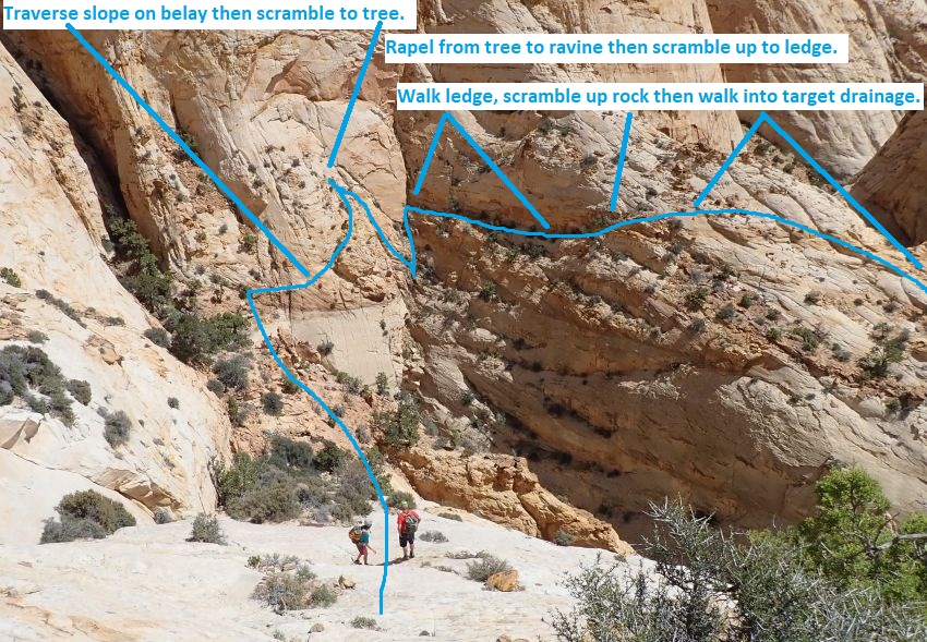
Gaining access to the main drainage that cuts all the
way through the reef involves crossing around the head of a deep canyon and
walking a ledge to get to the target drainage. It is recommended a rope used
to set a belay for everyone crossing the head of the deep canyon as it is
exposed over tall vertical wall. Once across the belayed portion you will
need to scramble up to a small tree, set an anchor and rappel down into the
head of the canyon where you can then scramble up about 20 feet to get to a
ledge. Walking the ledge and scrambling up sloped rock outcroppings allows
access to gentle slopes leading down into the target drainage. This portion
of the route is not well suited for the casual hiker or canyoneer as it is
exposed and extra caution should be exercised. Gaining access to the
main canyon is not for the faint of heart or those not comfortable with easy
but very exposed climbing.
The longest rap on the route is 110 feet and is the
rappel done to gain access to the top of the main drainage cutting all the
way through the reef. The other 4 rappels are 60 feet and under.
If you decide to start from the bottom near Notom Road and go to do only the
mid route technical section you would only need ropes for 60 foot rappels.
An exit vehicle is first set on a short dirt road off
of the Notom Road before driving up to begin the route from the Golden
Throne trail head at the end of Capitol Gorge road.
To get to the Trailhead
Start from the turn off of highway 24 to the Capitol Reef
Visitor Center. This is about 9.7 miles north on highway 24
from the town of Torrey, Utah, which is at the junction of
highways 12 and 24.
From the turn off to the Capitol Reef Visitor Center (vCapReefVisit)
follow the Scenic Drive road about 3.4 miles southeast to the
turn off for Grand Wash (extGrandWash).
Continue about 4.5 miles south on the scenic drive for about 4.5
miles to the turn off for Capitol Gorge (exCapGorgeRd).
Turn left and follow the Capitol gorge road (now a dirt road)
about 2.3 miles to the end at the Golden Throne trailhead
(pkCapGorge2).
To leave the Exit Vehicle / Escape Pod
From the junction of highway 24 and the Notom Road
(exNotom-hwy24) drive south on Notom road for 1.5 miles to the
turn off to BLMroad 0851 (exBlmRd0851).
Turn right onto BLM road 0851 and follow it south as it kind of
parallels the Notom Road.
After about 0.5 miles the road will get rough where only 4x4
vehicles can continue. Park here (pkReefRambleBt).
GPS coordinate information listed at the bottom. For information about waypoint naming and map symbols, refer to the
Glossary page.

Click the links for maps of the route.
Overview of the route and the drive.
Map of the entire route.
Zoomed in map 1 of route.
Zoomed in map 2 of route.
Zoomed in map 3 of route.
Zoomed in map 4 of route.
Super Zoomed Map of the mid route technical section.
The super zoomed map is of the section where we found
rope grooves and pictures on Instagram of the area.
not sure of the history or name others have given this section.
The Approach:
From the parking spot
(pkCapGorge2) Walk to
the northeast end of the
parking area and start
walking up the Golden
Throne trail.
About 0.4 miles farther
the trail crosses over a
drainage
(GoldenThro-01).
About 0.3 miles farther
the trail crosses over
another drainage
(GoldenThro-02).
About 0.4 miles farther
the trail crosses over a
drainage then goes up a
couple switch backs up
the other (west) side
(GoldenThro-03).
About 0.4 miles farther
the trail passes over
sections of slickrock
where cairns may
sometimes be found to
keep you on track
(GoldenThro-04).
About 0.3 miles farther
is a junction in the
trail (GoldenThro-05).
To continue on the Reef
Ramble route veer right
and follow well worn use
trails along the rim of
a drainage.
Note:
To follow the official
Golden Throne trail to
the view point at it's
end (GoldenThro-06),
veer left and walk 200
feet up to the southwest
to a view point on a
knoll.
About 400 feet north
from the junction the
trail jogs left then
right (ReefRmbl01)
passing though a minor
drainage with
vegetation. Work through
the vegetation and
follow use trails
continuing north.
About 0.3 miles farther
the use trails fade away
(ReefRmbl02) as the
route drops into then
follows north up a
drainage.
About 800 feet up the
drainage is a confluence
(ReefRmbl03) where a
minor drainage joins in
from the left (west) and
the main drainage
continues up to the
north into deep canyon.
Walk and scramble up the
steep slope northwest up
between the drainages.
The terrain is steep and
has sections of light
scrambling for about 0.3
miles to the top of the
slope and more level
ground.
At the top of the slope
(ReefRmbl04) up out of
the drainage, veer right
and walk north about 700
feet over to a ravine on
the left (west) side of
a tall sandstone peak.
From the base of a
ravine (ReefRmbl05)
running up the west side
of a tall sandstone
peak, follow north up
the ravine for about 400
feet to just before it
gets more steep and you
can scramble out the
right (east) side.
When you can leave the
ravine (ReefRmbl06)
before it gets more
steep, scramble up the
right (east) side up to
a wide saddle.
From the wide saddle
(ReefRmbl07) walk east
over to where you can
begin to see down into a
couple of canyons to the
east. The canyon you are
trying to access runs
down to the east but
access to that canyon is
blocked by the need to
cross a much deeper
canyon running south
back toward the Golden
Throne trail. Turn left
and walk north
contouring north along
the base of a cliff
wall.
About 350 feet north
along the base of the
cliff fall you will
begin to see
(ReefRmbl08) dirt and
rock filled area and you
can see the slopes
leading northeast down
toward the head of the
large canyon on the
right (east) then begin
down the slopes toward
the head of the canyon.
Route finding down the
steep slope will roughly
follow along side a
ravine running down to
the head of the large
canyon below.
Note:
You will now need to
cross the head of the
large canyon blocking
access to the Reef
Ramble drainage.
Doing so will involve an
easy but very exposed
traverse where belaying
each other is a good
idea. This is not
technical canyon but
since this is the first
place the route becomes
difficult and ropes are
a god idea, I thought
this a good spot to call
the head of the canyon /
route.
 Route to
cross the head of the canyon
blocking access to the main
drainage that goes down
through the Reef.
Route to
cross the head of the canyon
blocking access to the main
drainage that goes down
through the Reef.
The Canyoneering / Technical Section:
On the west side of the
head of the deep canyon
to cross
(ReefRmbl09Blay), set an
anchor from a tree and
use rope to belay the
first person over and up
to large rock debris
pile. That first
person can then sit and
anchor the other end of
the belay rope for those
who follow. Scramble
slash traverse about 80
feet over and up to the
boulder debris with good
features but very
exposed over high
vertical walls.
Note:
The goal is to gain
access to a ledge on the
other (east) side of the
deep canyon that can be
walked to get over to
the head of the Reef
Ramble drainage which
runs down to the east.
The ledge looks like it
may not work out but it
is much easier than it
looks from here. The
hard part is getting to
the ledge which involves
the traverse to boulder
debris, a scramble up to
a tree anchor used to
rap into the head of the
deep canyon and scramble
up to the ledge.
From the boulder pile
(ReefRmbl10Blay)
scramble up and around
the corner and up to a
small tree. Depending on
the route chosen this
can be more scary than
the roped traverse just
finished. The
small tree will be the
anchor for rap 1 on the
route.
Rap 1 (dReefRmbleR1)
anchored from a tree and
use about 110 feet of
rope to drop down into
the ravine at the head
of the deep canyon. Once
down in the ravine
scramble up about 20
feet to get to a wide
ledge on the other
(east) side. Walk that
ledge south about 150
feet to a sloped rock
outcropping along the
ledge.
Easily scrambled up the
rock outcropping
(ReefRmbl11) to gentler
slopes where you can
then walk / scramble
south down to the head
of the Reef Ramble
drainage which continues
down to the east.
Note:
On our visit here
2018-05-19 there was a
cairn between here and
the head of the Reef
Ramble drainage. We did
not see other cairns to
determine what the cairn
was directing people to.
Once at the head of the
Reef Ramble drainage
(ReefRmbl20) walk
northeast down canyon.
About 0.25 miles father
is the upper end
(ReefRmbl21) of 900 foot
long narrow section with
a short open spot mid
way through. A few easy
stem / bridges over
small pools and a few
easy 10 to 12 foot stem
downclimbs.
About 800 feet farther
the canyon opens up
again (ReefRmbl22) after
900 foot long narrow
section.
About 150 feet farther
is a short slot
(ReefRmbl23) with a
couple potholes and a
large shelf. Both are
easily bypassed by going
up and over on the RDC
side then down a short
ravine back into the
main drainage.
Interesting tall
mushroom shaped rock in
the LDC side ravine
after the bypass.
About 400 feet farther
are a couple of potholes
(ReefRmbl24) easily
bypassed on the RDC
side.
About 100 feet farther
is the top end
(ReefRmbl25) of 100 foot
long slot with some
drops. Can be bypassed
by going way up on the
LDC side then walking
steep slopes back to the
canyon floor.
About 150 feet farther
is the second rap on the
route.
Rap 2 (dReefRmbleR2)
anchored from the root
of a small shrub and
drops about 50 feet down
steeply sloped
slickrock. This drop
could be downclimbed but
would be sketchy and is
much safer using a rope.
About 450 feet farther
is the top (ReefRmbl26)
of boulder debris with
downclimb of about 20
feet to a long very wide
pool to stem over. This
section can be bypassed
by scrambling up steep
slopes on the RDC (east)
side then walking a ramp
system back to the
canyon floor about 300
feet down canyon.
About 750 feet farther
is the top end
(ReefRmbl27) of 300 foot
long slot that starts as
wide trough then ends
with a moderate stem
over a long pool.
About 0.3 miles farther
is a bypass (ReefRmbl28)
of a ravine dropping in
in on LDC side by
walking wide slickrock
ledge on the RDC side.
About 0.4 miles farther
is a drop (ReefRmbl29)
of about 30 feet
bypassed by carefully
traversing sloped
slickrock on the LDC
side then scrambling
back to the wash below.
About 400 feet farther
is a long pool
(ReefRmbl30) that can be
bypassed if desired by
going up and over on the
LDC side then scrambling
steep slopes back to the
wash below.
About 0.35 miles farther
the wash begins to
narrow (ReefRmbl31) and
get pretty as it
approaches a sharp right
hand bend about 600 feet
down canyon.
Note:
This is the start of the
mid route technical
section that we found
rope grooves in and
later found pictures of
on instagram. I
do not know what other
people have done this
portion of the route or
know what they may have
named it.
About 700 feet farther
is rap 3 on the route or
rap 1 if you hike in
from the bottom to enjoy
this mid route technical
section.
Rap 3 (dReefRmbleR3)
anchored from a large
rock on the LDC ledge
and drops about 60 feet
down beyond the first
large pothole. At the
bottom of the rap you
are in the second
pothole with an easy
scramble up out of about
6 feet but could be
deeper if sand scours
out. A partner
assistable drop of about
10 feet drops down into
the 3rd pothole. From
the 3rd pothole it is a
6 foot partner assist
out to begin rap 4.
Note:
The first pothole
bypassed by the LDC rap
is about 12 feet deep
and sand filled so it
can be deeper.
Rap 4 (dReefRmbleR4)
exits the deep slot
portion of this section
and is anchored using a
sandtrap from the 3
pothole and drops about
55 feet down vertical
wall to open wash below.
About 170 feet farther
is the top (ReefRmbl32)
of a moderately
difficult crack
downclimb of about 20
feet to bypass a shelf
in the canyon.
Continuing down canyon
slowly becomes narrow
going into wide V-slot
narrows with easy
galumphing.
A little over 200 feet
down canyon of the down
climb is rap 5.
Rap 5 (dReefRmbleR5)
anchored from a small
bush head high and about
25 feet back and drops
about 25 feet down
vertical wall.
About 200 feet Farther
is a left hand bend
(ReefRmbl33) in the
canyon with a fin
dividing the wash from a
ravine in a way that
makes it appear the
canyon splits. Down
canyon from here is a
series of open and
closed sections with
short easy downclimbs
and some easy galumphing
for about 1000 feet to
where it opens to wide
wash again.
About 800 feet farther
the canyon opens
(ReefRmbl34) to wide
wash after 1000 foot
long section of easy
downclimbs and
galumphing.
1000 feet farther is a
steep rubble filled
ravine (ReefRmbl35)
drops in from LDC and
the canyon is getting
more scenic with
colorful red rock.
About 500 feet farther
is a low angle rubble
filled ravine
(ReefRmbl36) drops in
from LDC.
Note:
The walls on the LDC
side just down canyon of
here look like they can
easily be scrambled up
to the next higher
ledge.
About 750 feet farther a
large major drainage
joins (ReefRmbl37) in
from RDC.
About 0.4 miles farther
is a shelf (ReefRmbl38)
of about 30 feet tall
where you can scramble
down a weakness on the
LDC side to dirt slopes
to the floor below. The
1000 feet of wash just
below this shelf is
pretty as it cuts
through a red and ledgy
rock layer.
About 1000 feet farther
the canyon opens up
(ReefRmbl39) to wider
wash after passing
through a 1000 foot long
section of pretty, red,
ledgy rock layers.
About 1.2 miles farther
you will begin to notice
signs of a road
traveling up the wash
begin (ReefRmbl40) to
show up and get more
defined as you walk down
the wash.
About 800 feet farther
the wash crosses
(ReefRmbl41) a park
boundary sign and an
open fence.
About 0.5 miles farther
a large wash joins
(ReefRmbl42) in from
LDC.
About 800 feet farther
leave wash (ReefRmbl43)
and walk use trails and
dirt road back to the
exit car (pkReefRambleBt)
about 350 feet away.
Downloadable GPX files
available at
BG-Gear Store
(easier than manual entry and a great way to support
Bluugnome).
Waypoint naming convention and map symbol information can be found on the Glossary page.
Elevations are approximate.
BEFORE
manually entering coordinates set your system to WGS84 datum and Lat/Lon hddd.ddddd° coordinate format.
Inconsistent datum's and coordinate formats will result in location errors.
Click to show / expand the list of waypoints below........
| Reef Ramble (1) - Drive in to Trailhead |
- vCapReefVisit
Lat/Lon (WGS84): N 38.29111
W -111.26180
Elev: 5,208 Feet
Capitol Reef Visitor Center.
- extGrandWash
Lat/Lon (WGS84): N 38.25622
W -111.23287
Elev: 5,580 Feet
Exit off of the scenic drive to a dirt road into Grand Wash.
- exCapGorgeRd
Lat/Lon (WGS84): N 38.20802
W -111.19523
Elev: NaN Feet
Exit off of the Scenic Drive onto the Capitol Gorge road. Capitol Gorge Road goes off to the east and turns from dirt to pavement a little over 200 feet down the road just past a large parking area. Pleasant Creek Road continues south and also turns to dirt just past this exit.
- pkCapGorge2
Lat/Lon (WGS84): N 38.20960
W -111.16914
Elev: NaN Feet
|
| Reef Ramble (2) - Drive in to set exit vehicle |
- exNotom-hwy24
Lat/Lon (WGS84): N 38.28351
W -111.12851
Elev: NaN Feet
- exBlmRd0851
Lat/Lon (WGS84): N 38.26332
W -111.12825
Elev: NaN Feet
Exit off of Notom Road to dirt BLM road 0851. On some maps this is called the Back Road to Notom.
- pkReefRambleBt
Lat/Lon (WGS84): N 38.25706
W -111.12579
Elev: 5,075 Feet
Park vehicle here for the exit of the Reef Ramble route. 4WD can drive farther into this road, drop into the wash and follow up the wash to set the exit vehicle farther up. Most vehicles will stop and park here.
|
| Reef Ramble (3) - Approach |
- pkCapGorge2
Lat/Lon (WGS84): N 38.20960
W -111.16914
Elev: NaN Feet
- tGoldenThrone
Lat/Lon (WGS84): N 38.20961
W -111.16954
Elev: NaN Feet
Golden Throne trailhead.
- GoldenThro-01
Lat/Lon (WGS84): N 38.21060
W -111.17363
Elev: NaN Feet
Trail crosses over a drainage.
- GoldenThro-02
Lat/Lon (WGS84): N 38.21134
W -111.17597
Elev: NaN Feet
Trail crosses over a drainage.
- GoldenThro-03
Lat/Lon (WGS84): N 38.21230
W -111.17945
Elev: NaN Feet
Trail crosses over a drainage then goes up a couple switch backs up the other (west) side.
- GoldenThro-04
Lat/Lon (WGS84): N 38.21309
W -111.18280
Elev: NaN Feet
Trail passes over sections of slickrock where cairnsmay sometimes be found to keep you on track.
- GoldenThro-05
Lat/Lon (WGS84): N 38.21481
W -111.18673
Elev: NaN Feet
Junction in the trail.
To follow the official Golden Throne trail to the view point at it's end, veer left and walk 200 feet up to the southwest to a view point on a knoll.
To continue on the Reef Ramble route veer right and follow well worn use trails along the rim of a drainage.
- ReefRmbl01
Lat/Lon (WGS84): N 38.21579
W -111.18672
Elev: NaN Feet
Trail jogs left then right passing though a minor drainage with vegetation. Work through the vegetation and follow use trails continuing north.
- ReefRmbl02
Lat/Lon (WGS84): N 38.21929
W -111.18910
Elev: NaN Feet
Use trails fade away as route drops into then follows north up a drainage.
- ReefRmbl03
Lat/Lon (WGS84): N 38.22111
W -111.19061
Elev: NaN Feet
Confluence where a minor drainage joins in from the left (west) and the main drainage continues up to the north into deep canyon. Walk and scramble up the steep slope northwest up between the drainages. The terrain is steep and has sections of light scrambling for about 0.3 miles to the top of the slope and more level ground.
- ReefRmbl04
Lat/Lon (WGS84): N 38.22310
W -111.19490
Elev: 6,680 Feet
Top of the slope up out of the drainage. Veer right and walk north about 700 feet over to a ravine on the left (west) side of a tall sandstone peak.
- ReefRmbl05
Lat/Lon (WGS84): N 38.22507
W -111.19452
Elev: NaN Feet
Base of a ravine running up the west side of a tall sandstone peak. Follow north up the ravine for about 400 feet to just before it gets more steep and you can scramble out the right (east) side.
- ReefRmbl06
Lat/Lon (WGS84): N 38.22618
W -111.19470
Elev: NaN Feet
Leave the ravine here before it gets more steep and scramble up the right (east) side up to a wide saddle.
- ReefRmbl07
Lat/Lon (WGS84): N 38.22631
W -111.19428
Elev: 6,790 Feet
From this wide saddle walk east over to where you can begin to see down into a couple of canyons to the east. The canyon you are trying to access runs down to the east but access to that canyon is blocked by the need to cross a much deeper canyon running south back toward the Golden Throne trail. Turn left and walk north contouring north along the base of a cliff wall.
- ReefRmbl08
Lat/Lon (WGS84): N 38.22720
W -111.19411
Elev: 6,780 Feet
Contour north along the base of the cliff a short distance into a dirt and rock filled area and you can see the slopes leading northeast down toward the head of the large canyon on the right (east) then begin down the slopes toward the head of the canyon. Route finding down the steep slope will roughly follow along side a ravine running down to the head of the large canyon below.
- ReefRmbl09Blay
Lat/Lon (WGS84): N 38.22894
W -111.19376
Elev: NaN Feet
On the west side of the head of the deep canyon to cross (ReefRmbl09Blay), set an anchor from a tree and use rope to belay the first person over and up to large rock debris pile. That first person can then sit and anchor the other end of the belay rope for those who follow. Scramble slash traverse about 80 feet over and up to the boulder debris with good features but very exposed over high vertical walls.
Note: The goal is to gain access to a ledge on the other (east) side of the deep canyon that can be walked to get over to the head of the Reef Ramble drainage which runs down to the east. The ledge looks like it may not work out but it is much easier than it looks from here. The hard part is getting to the ledge which involves the traverse to boulder debris, a scramble up to a tree anchor used to rap into the head of the deep canyon and scramble up to the ledge.
|
| Reef Ramble (4) - Route through the Reef |
- ReefRmbl09Blay
Lat/Lon (WGS84): N 38.22894
W -111.19376
Elev: NaN Feet
On the west side of the head of the deep canyon to cross (ReefRmbl09Blay), set an anchor from a tree and use rope to belay the first person over and up to large rock debris pile. That first person can then sit and anchor the other end of the belay rope for those who follow. Scramble slash traverse about 80 feet over and up to the boulder debris with good features but very exposed over high vertical walls.
Note: The goal is to gain access to a ledge on the other (east) side of the deep canyon that can be walked to get over to the head of the Reef Ramble drainage which runs down to the east. The ledge looks like it may not work out but it is much easier than it looks from here. The hard part is getting to the ledge which involves the traverse to boulder debris, a scramble up to a tree anchor used to rap into the head of the deep canyon and scramble up to the ledge.
- ReefRmbl10Blay
Lat/Lon (WGS84): N 38.22903
W -111.19350
Elev: NaN Feet
Boulder pile where the first person across can sit down to anchor the rope for those who follow. After getting across, scramble up and around the corner and up to a small tree. Depending on the route chosen this can be more scary than the roped traverse just finished.
- dReefRmbleR1
Lat/Lon (WGS84): N 38.22918
W -111.19353
Elev: NaN Feet
Rap 1 - Reef Ramble. Anchored from a tree and use about 110 feet of rope to drop down into the ravine at the head of the deep canyon. Once down in the ravine scramble up about 20 feet to get to a wide ledge on the other (east) side. Walk that ledge south about 150 feet to a sloped rock outcropping along the ledge.
- ReefRmbl11
Lat/Lon (WGS84): N 38.22885
W -111.19322
Elev: NaN Feet
Sloped rock outcropping along the ledge that is easily scrambled up to gentler slopes where you can then walk / scramble south down to the head of the Reef Ramble drainage which continues down to the east.
Note: On our visit here 2018-05-19 there was a cairn between here and the head of the Reef Ramble drainage. We did not see other cairns to determine what the carin was directing people to.
- ReefRmbl20
Lat/Lon (WGS84): N 38.22826
W -111.19287
Elev: 6,600 Feet
Head of the long Reef Ramble Drainage.
- ReefRmbl21
Lat/Lon (WGS84): N 38.22993
W -111.18898
Elev: NaN Feet
Upper end of 900 foot long narrow section with a short open spot mid way through. A few easy stem / bridges over small pools and a few easy 10 to 12 foot stem downclimbs.
- ReefRmbl22
Lat/Lon (WGS84): N 38.23150
W -111.18660
Elev: NaN Feet
Opens up again after 900 foot long narrow section.
- ReefRmbl23
Lat/Lon (WGS84): N 38.23190
W -111.18637
Elev: NaN Feet
Short slot with a couple potholes and a large shelf. Both are easily bypassed by going up and over on the RDC side then down a short ravine back into the main drainage. Interesting tall mushroom shaped rock in the LDC side ravine after the bypass.
- ReefRmbl24
Lat/Lon (WGS84): N 38.23253
W -111.18557
Elev: NaN Feet
Couple of potholes easily bypassed on the RDC side.
- ReefRmbl25
Lat/Lon (WGS84): N 38.23280
W -111.18549
Elev: NaN Feet
Top end of 100 foot long slot with some drops. Can be bypassed by going way up on the LDC side then walking steep slopes back to the canyon floor.
- dReefRmbleR2
Lat/Lon (WGS84): N 38.23311
W -111.18518
Elev: NaN Feet
Rap 2 - Reef Ramble. Anchored from the root of a small shrub and drops about 50 feet down steeply sloped slickrock. This drop could be downclimbed but would be sketchy and is much safer using a rope.
- ReefRmbl26
Lat/Lon (WGS84): N 38.23416
W -111.18449
Elev: NaN Feet
Top of boulder debris with downclimb of about 20 feet to a long very wide pool to stem over. This section can be bypassed by scrambling up steep slopes on the RDC (east) side then walking a ramp system back to the canyon floor about 300 feet down canyon.
- ReefRmbl27
Lat/Lon (WGS84): N 38.23550
W -111.18443
Elev: NaN Feet
Top end of 300 foot long slot that starts as wide trough then ends with a moderate stem over a long pool.
- ReefRmbl28
Lat/Lon (WGS84): N 38.23888
W -111.18053
Elev: NaN Feet
Bypass ravine dropping in in on LDC side by walking wide slickrock ledge on the RDC side.
- ReefRmbl29
Lat/Lon (WGS84): N 38.24165
W -111.17502
Elev: NaN Feet
Drop of about 30 feet bypassed by carefully traversing sloped slickrock on the LDC side then scrambling back to the wash below.
- ReefRmbl30
Lat/Lon (WGS84): N 38.24275
W -111.17449
Elev: NaN Feet
Long pool that can be bypassed if desired by going up and over on the LDC side then scrambling steep slopes back to the wash below.
- ReefRmbl31
Lat/Lon (WGS84): N 38.24576
W -111.16960
Elev: NaN Feet
Wash begins to narrow and get pretty as it approaches a sharp right hand bend about 600 feet down canyon.
- dReefRmbleR3
Lat/Lon (WGS84): N 38.24545
W -111.16771
Elev: NaN Feet
Rap 3 - Reef Ramble. Anchored from a large rock on the LDC ledge and drops about 60 feet down beyond the first large pothole. At the bottom of the rap you are in the second pothole with an easy scramble up out of about 6 feet but could be deeper if sand scours out. A partner assistable drop of about 10 feet drops down into the 3rd pothole. From the 3rd pothole it is a 6 foot partner assist out to begin rap 4.
Note: The first pothole bypassed by the LDC rap is about 12 feet deep and sand filled so it can be deeper.
- dReefRmbleR4
Lat/Lon (WGS84): N 38.24537
W -111.16792
Elev: NaN Feet
Rap 4 - Reef Ramble. Anchored using a sandtrap from the 3 pothole and drops about 55 feet down vertical wall to open wash below.
- ReefRmbl32
Lat/Lon (WGS84): N 38.24507
W -111.16839
Elev: NaN Feet
Top of a moderately difficult crack downclimb of about 20 feet to bypass a shelf in the canyon. Continuing down canyon slowly becomes narrow going into wide V-slot narrows with easy galumphing.
- dReefRmbleR5
Lat/Lon (WGS84): N 38.24449
W -111.16860
Elev: NaN Feet
Rap 5 - Reef Ramble. Anchored from a small bush head high and about 25 feet back and drops about 25 feet down vertical wall.
- ReefRmbl33
Lat/Lon (WGS84): N 38.24404
W -111.16854
Elev: NaN Feet
Left hand bend in the canyon with a fin dividing the wash from a ravine in a way that makes it appear the canyon splits. Down canyon from here is a series of open and closed sections with short easy downclimbs and some easy galumphing for about 1000 feet to where it opens to wide wash again.
- ReefRmbl34
Lat/Lon (WGS84): N 38.24477
W -111.16557
Elev: NaN Feet
Opens to wide wash after 1000 foot long section of easy downclimbs and galumphing.
- ReefRmbl35
Lat/Lon (WGS84): N 38.24536
W -111.16281
Elev: NaN Feet
Steep rubble filled ravine drops in from LDC and the canyon is getting more scenic with colorful red rock.
- ReefRmbl36
Lat/Lon (WGS84): N 38.24583
W -111.16095
Elev: NaN Feet
Low angle rubble filled ravine drops in from LDC.
Note: The walls on the LDC side just down canyon of here look like they can easily be scrambled up to the next higher ledge.
- ReefRmbl37
Lat/Lon (WGS84): N 38.24472
W -111.16035
Elev: NaN Feet
Large major drainage joins in from RDC.
- ReefRmbl38
Lat/Lon (WGS84): N 38.24677
W -111.15458
Elev: NaN Feet
Shelf of about 30 feet tall where you can scramble down a weakness on the LDC side to dirt slopes to the floor below. The 1000 feet of wash just below this shelf is pretty as it cuts through a red and ledgy rock layer.
- ReefRmbl39
Lat/Lon (WGS84): N 38.24818
W -111.15251
Elev: NaN Feet
Canyon opens up to wider wash after passing through a 1000 foot long section of pretty, red, ledgy rock layers.
- ReefRmbl40
Lat/Lon (WGS84): N 38.25034
W -111.13536
Elev: NaN Feet
Signs of a road traveling up the wash begin to show up and get more defined as you walk down the wash.
- ReefRmbl41
Lat/Lon (WGS84): N 38.25075
W -111.13251
Elev: NaN Feet
Wash crosses a park boundary sign and an open fence.
- ReefRmbl42
Lat/Lon (WGS84): N 38.25603
W -111.12903
Elev: NaN Feet
Large wash joins in from LDC.
- ReefRmbl43
Lat/Lon (WGS84): N 38.25609
W -111.12652
Elev: NaN Feet
Leave wash and walk use trails and dirt road back to the exit car.
- pkReefRambleBt
Lat/Lon (WGS84): N 38.25706
W -111.12579
Elev: 5,075 Feet
Park vehicle here for the exit of the Reef Ramble route. 4WD can drive farther into this road, drop into the wash and follow up the wash to set the exit vehicle farther up. Most vehicles will stop and park here.
|