Canyoneering Route Description
Pandora's Box - 4A (B) IV R
Capitol Reef National Park, Utah.
06-12-11, 7 people, 1 Day (Travel time in route 12.75 hours)

10-22-16, 5 people, 1 Day (Travel time in route 14 hours)
12-18-2021, 5 people, 1 Day (Travel Time in route 12.75 hours) -
Using long exit down Spring Canyon.
Time Required - 11 to 14 hours
Distance using Upstream Exit option - 10.5 miles Total, 1.5 miles Technical
Distance using Downstream Exit option - 13.9 miles Total, 1.5 miles Technical
Rappels - 7 Rappels, Longest Rappel 150 feet.
Elevation Range - 6515 - 7640 Feet
Shuttle Required -Optional (3.5 miles for
Downstream Exit option) Vehicle - Passenger
(if you are careful)
Permit Required - Yes
Rappelling and anchor gear, Ropes and or pull cords for rappels up
to 150 feet and 100 feet of 1 inch webbing for sling placement.
Optionally a 170 foot rope can
be used to get past a 20 foot
ledge at the bottom of rap 7
(the final rap). The ledge
is easy to scramble down from so
the 150 foot rope is still a
good option.
A compass or GPS is recommended to have along for part of the
approach route.
In full water conditions there is intermittent water through
the canyon that is mostly waist deep. There may also be a
couple short mandatory swims.
During warm and hot weather wet suits are generally not needed.
During cooler times a wetsuit for the waist down can be useful as
most water is only waist deep. When cold out you could bring
wetsuits for the upper body but remember this will add to the bulk
of gear to carry for this long route. Another option is to
stuff your shirts in dry bags while you deal with a couple short
swims then put them back on after crossing and drying off. A
brief moment of cold water may be more desirable to some than
lugging a large wetsuit.
A trip through Pandora's Box leaves you feeling like an ant
navigating a huge maze through fracture zones in the sandstone. The
lower section is convoluted with narrow sections and short wide
spots that make a clear route description difficult. Over all,
Pandora's Box is a big day adventure and well worth it.
The first 2.2 miles of the approach route follows an old cattle
trail up onto Meeks Mesa. Once up on the mesa you will
navigate through rolling desert to your destination. The
rolling desert has few landmarks that can be used and the tilt of
the terrain tends to make you wander in a direction you did not
intend to go. A compass may be a
good tool here to keep you on track. Better yet a GPS would be
very useful here. If using the short exit a GPS would also be
good to have along to navigate back to the cattle trail down off the
mesa.
Pandoras's Box Canyon has multiple skinny spot where large people my
have difficulty. Those 200 pounds and larger should understand
they will need to work harder in a few skinny sections than their
little friends. In a couple of spots large people will need to
stem up over skinny spots where they simply do not fit low. We
were able to get a 240 pound guy through Pandora's but it did take
some effort.
Pandora's Box involves a few sections of high stemming. People
should be ok with the idea of needing to do some high stemming
before deciding to do this route. The high stemming portions
in Pandora's Box are short and only needed to get you over skinny
sections. The longest and highest section of stemming is in a slot
just before reaching the confluence with the Left (south) fork of
Pandora's and is optional. In this optional slot you will stem
up to about 25 feet off the deck. The optional slot can be
bypassed on the RDC side by climbing up a ramp and ledges then
following along the RDC canyon wall over to and down a ravine back
into the canyon at the confluence of the right ad left forks.
The short sections of stemming is what gives Pandora's the R rating.
If you choose to bypass the above mentioned optional slot, the
sections of high stemming are very short and go almost un-noticed as
you go over the skinny spots.
Pandora's Box is given a rating of A (B) for water since the range
of water exposure can vary from low water providing only a few spots
to wade up to full water conditions with significant sections of
wading and a couple possible short swims.
Pandora's Box is rated a 4 in technical difficulty due to anchoring
challenges. One anchors in particular is difficult to get to making
rigging and inspection difficult. Multiple anchors in Pandora's Box
require good anchoring skills to set up and or evaluate properly.
The Pandora's Box route has significant elevation gain.
The approach route to the head has almost 1100 feet of gain starting at 6515 feet and climbs to over 7600 feet
onto Meeks Mesa. If you use the upstream exit option the
exit route adds almost another 1100 feet of gain starting from about 6540 up to over
7600 feet again. The downstream exit has very little elevation
gain but adds extra miles.
With either exit option it adds up to a big day.
The lower portion of Pandora's Box can be very slow as you navigate
through the narrows. If you feel you are moving fast and
making good time early in the day, don't get too relaxed as the time
commitment is still ahead.
Note / Warning - Exit Options:
Please read this note about exit options for Pandora's Box.
The Capitol Reef rangers contacted me asking for an update in the
information for the Pandora's Box route. They would like
people to be aware there are two exit options for Pandora's Box.
After the Pandora's Box drainage ends and dumps into Spring Canyon
there are two ways to exit, an Upstream Exit option
OR a Downstream Exit option.
The Upstream Exit option is to turn left and walk west up Spring canyon
about 2 miles then climb up an
unmarked route up onto the
the mesa top,
walk across the mesa then back down to the start point of the route.
The total distance of the Upstream Exit option is 5.6 miles but involves an
exit climb / scramble out that has proven very difficult to route find for some
parties. Especially if exiting in the dark.
If you plan to use the Upstream Exit option, be aware that some parties have
had severe difficulty locating and navigating the climb up to the mesa top. The
climb up to the mesa top on the Upstream Exit option is difficult to
accurately describe in written or verbal form. Good route finding
and scrambling skills are required for the climb up onto Meeks
Mesa. Darkness can make this route extremely difficult or
impossible. The climb out is strongly discouraged during dim or
dark hours.
The Downstream Exit option is to turn right and walk 6.2 miles to southeast
down Spring Canyon then 2.8 miles west up Chimney Rock Canyon to the
Chimney Rock trailhead. The total distance for the Downstream
Exit option
is 9 miles but involves no difficult route finding. The
confluence of Spring and Chimney Rock Canyons also has signage
pointing to the Chimney Rock Trailhead.
I have not personally done the Downstream Exit option. As a courtesy
to the Notional Park Service I am
passing along what the park service would like people to know about
their options.
If you find yourself exiting the Pandora's Drainage with little
daylight left consider using the Downstream Exit option. The
Downstream Exit option may take more time but does not have a difficult climb
and is easy to follow. If you are not confident in your
scrambling or route finding skills you also may want to consider the
Downstream Exit option rather you have daylight or not. Using the
Upstream Exit option in the dark or with poor route finding skills
could end up taking considerably more time and effort than the long
exit or possibly end with a call to SAR.
If you use the Downstream Exit option you will need to set a shuttle
vehicle prior to your route at the Chimney Rock Trailhead. The
Chimney Rock Trailhead is 3.5 miles east of the Pandora's Box
Trailhead on highway 24. If you planned to use the Upstream Exit
option
but change your mind due to darkness or other circumstances you can
still use the long exit option but will need to find a way back to
the Pandora's Box Trailhead to your vehicles. You can walk the
road 3.5 miles or hitchhike. The rangers at Capitol Reef
National Park have told me that hitchhiking within the park is legal
and want people to know they are allowed to hitch hike if they need
a ride between trailheads. It is better to have a late night
exiting because you decided to use the Downstream Exit option than it
is to follow the Upstream Exit option in darkness and go epic after getting
lost.
Also of note the park rangers do not want to shut routes down.
It is acceptable to use either the upstream or downstream exit for
Pandora's Box. Both are acceptable routes as far as the park
service is concerned. The park service does however want people to
be aware there have been route finding issues on the the Upstream
Exit option making the Downstream Exit option more desirable in
some cases. Feel free to contact the Capitol Reef National
Park (435) 425-3791 if you have questions.
To get to the Trailhead
From the junction of highways 12 and 24, drive east on highway
24 toward Capitol Reef for 3.3 miles to a turn off on the left
for a dirt road (extPandora).
OR
From the visitor center in Capitol Reef, drive 6.5 miles west on
highway 24 to a turn off on the right for a dirt road (extPandora).
The turn off from highway 24 (extPandora) is a dirt road leading
into a large open flat desert area. This area is frequently
used for camping. Most passenger cars should have little issue
here except for a few rocks to navigate around just after
getting off the highway.
After turning off the highway veer left (north west) and follow
the dirt road about 750 feet to a very large clear area (pkPandora).
To leave the Exit Vehicle / Escape Pod
No exit vehicle is needed if you plan to use the Upstream Exit
option. This would be done as a loop route.
If you intend to use the Downstream Exit option you will need to
set an exit vehicle at the Chimney Rock Trailhead. To do this
start from the Pandora's Box Trailhead and drive 3.5 miles east
on highway 24 to the Chimney Rock Trailhead and leave the exit
vehicle there.
GPS coordinate information listed at the bottom. For information about waypoint naming and map symbols, refer to the
Glossary page.

Click the links for maps of the route.
Map of entire route with
Upstream Exit.
Map of entire route with
Downstream Exit.
Map of the approach and tech section.
Map of the technical section
and exit..
The Approach:
From the parking area (pkPandora) look for and follow a trail
leading north up through the hills at the base of the cliff band.
About 0.2 miles up the trail is the start (wPandoraRP-01) of a section of boulders
to navigate your way through. The trail will weave through these
boulders and be less noticeable in some spots but is overall easy to
follow.
About 0.3 from the trailhead, the trail will top out (wPandoraRP-02)
on the large wide open bench above the parking area. After getting
up onto the bench turn left (northeast) and walk the very wide bench
look for well used use trails forming. The use trails has a
few spots that fade away but is well traveled and easy to follow.
About 0.8 miles along the bench, the trail will pass by a collection
of petrified wood (wPandoraRP-03) next to the trail. Some of these
pieces are quite large and pretty.
About 0.4 miles farther the trail gradually sweeps right
to travel north (wPandoraRP-04) along the west end of the
cliff band you have been next to.
About 0.3 miles farther, the trail will intersect with a small
drainage (wPandoraRP-05). When you get to the drainage it
looks like the trail meets it then goes up or down it. Cross over
the drainage and start up the slope on the other side where a faint
path can be seen going east up the left side
of the large ravine that ramps up to the east to the top of the mesa.
About 0.2 miles up the ravine is the start (wPandoraRP-06) of some switch backs.
The switchbacks cut up through sandstone and cross over to the right
(southish) side of the ravine and continues up toward the mesa top.
As the route traverses and climbs up the ravine from here, the path
is a bit more difficult to follow because it travels over slick rock
making a well worn path less visible. Keep an eye out
for the occasional cairn and remember this is still
part of an old cattle trail. It is amazing to think cattle
traveled up and down this route. After about 300 feet the trail becomes well defined
again and easy to follow.
A little over 500 feet farther, the trail tops out on top of Meeks Mesa
in an area known as Sunrise Point.
Note:
If you have a little extra time when you top out
on the mesa, take a moment to turn right (south) and walk about 60
feet to where you can look south back toward highway
24. The area here is known as Sunrise Point an offers a scenic
treat worth taking a moment for.
From the top out on Meeks Mesa / Sunrise Point (tMeekTrailTop), turn left and
route find north-ish across
rolling desert on a bearing of 13 degrees true north (not magnetic).
There are no landmarks or well defined use trails making a GPS helpful as the
tilt of the terrain can lead you off course unknowingly.
Navigation Note:
From the top out on the mesa (Sunrise Point) it is important to stay
on course to get to a drainage at the intended location. With
there being no landmarks or well defined use trails, a GPS or strict
navigation by compass can be very useful. If not
using GPS or compass you may get to the drainage upstream or
downstream of the intended location. Upstream of the intended
location the drainage is shallow and may be easily crossed with out
knowing it making further navigation difficult.
About 0.45 miles from Sunrise Point the route drops into a drainage (wPandoraRP-07)
that runs down to the right (east). To continue to the right
(north) fork of Pandora's Box, cross over the drainage, go up the
slope on the other side and continue north.
Note:
Following east down this drainage would lead to the left
(south) fork of Pandora’s Box
and is not the fork covered here. An alternate route to the
Right (north) fork of Pandora's Box would be to follow this drainage
down to the left fork of then rim walk around to the head of the
left fork.
About 800 feet north you will drop into the drainage (wPandoraRP-08)
leading down to the right (north) fork of Pandora's Box. Turn
right and travel east down this drainage. Depending on where you
dropped into this drainage you may encounter a couple drops in the
wash of about 10 feet each to scramble down. About 1000 feet down
the drainage the slickrock slot begins to form at the head of the
right (north) fork (yPandoraRF-Tp).
The Canyoneering / Technical Section:
From the
head of the right (north) fork of Pandora's Box where a deep slot
begins to form (yPandoraRF-Tp) do not follow down into the slot.
Instead walk along the RDC (south) side for about 450 feet to where
you can easily scramble down into the canyon just downstream of a
tree (wPandoraRP-09).
Just down canyon of the entry is an easy down climb of about 15 feet in a
narrow slot to a series of two potholes, each about waist deep if full,
with a short narrow slot between them. On the other side of the
second pool is rap 1.
Rap 1 (dPandoraR1-3) is anchored from a log jammed between the walls and drops about 65 feet
down a mostly vertical wall in a narrow chute.
After rap 1 is a pothole that can be waist deep if full then a sloped
downclimb of about 10 feet to a small sand
filled pothole with rap 2 on the other side.
Rap 2 is anchored from a log wedged between the walls about 20 feet back
and drops about 40 feet down a mostly vertical wall with
an awkward over hanging start.. Extending the anchor webbing for
rap 2 will reduce rope grooving but also make the start of the rap more
awkward. An extended anchor with the rap ring jut over the edge
and a courtesy loop can be a good solution here.
Rap 3 is about 40 feet down canyon of rap 2, is anchored from a dead man anchor about 15 feet back
and drops about 30 feet down a sloped wall.
Note:
Raps 2 and 3 can be combined
if there are insufficient anchor materials for rap 3, but will add rope
pull issues and should be avoided if possible.
About 40 feet after rap 3 the walls become skinny where you will need to
stem / climb up about 10 feet off the deck over choke stones. On
the other side of the choke stones is a drop of of 15 to 20 feet that
can be downclimbed elevator style but will be difficult as the RDC wall
flares. Optionally a handline can be set from one of the choke
stones to aid in the downclimb.
About 50 feet down canyon between narrow walls is a downclimb of about 25 feet
down a deep, dark, narrow twisted
flute. Just after is one more downclimb of about 10 feet followed
by a tight section about 20 feet long where most people will need to stem
up about 15 feet off the deck to get over. About 50 feet farther the canyon opens up (wPandoraRP-10).
walk down the wide canyon
about 450 feet to a rock boulder debris area (wPandoraRP-11) on the LDC
(north) side.
When you get to the boulder debris area (wPandoraRP-11) area stay to the
LDC (north) side where you can scramble / downclimb the rock pile then
down a narrow chimney downclimb of about 10 feet next to the LDC wall.
From the bottom of the boulder debris area, walk down canyon about about
100 feet to ravine / ramp going up the RDC side (wPandoraRP-12) where
you can decide to go through or bypass the optional high stemming slot.
Note:
Optionally you can bypass the boulder debris area on the RDC side to
an
optional rappel of about 35 feet to the bottom of the boulder debris
area. Downclimbing through the boulders is faster, easier and more
fun than setting up the optional rappel.
From the bottom of the ravine / ramp going up the RDC side
(wPandoraRP-12) you can decide to go through or bypass the optional high
stemming slot about 350 feet long. Continuing down the water
course the canyon becomes too
skinny for on the ground travel. The first 100 feet
will require most people to stem up about
20 feet off the deck. The remaining 250 feet can be traveled along the floor for small people but
larger people will still need to stem over a few tighter parts.
After the high stemming slot walk about 250 feet down wide canyon to
where the left (south) fork of Pandora's Box joins in from the RDC side
(jPandoraLF-RF).
Note - Bypass of the optional high stemming slot.
To
bypass the optional high stemming slot do not continue down canyon past
the ravine / ramp. Instead scramble / climb up the ravine to get
to a large shelf on the RDC side of the canyon. When you get up to
the shelf stay to the far right over the top of a ravine
(wPandoraRP-12a) that can be scrambled down into the wide open wash of
the left (south) fork of Pandora's Box. Walk the wash down to the
confluence of the Pandora's forks (jPandoraLF-RF).
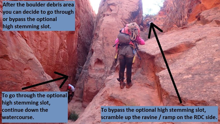 To go through the optional high stemming slot, continue down the watercourse.
To bypass the optional high stemming slot, go up the ravine / ramp on the RDC side.
From the confluence, walk down the wide wash about 0.25 the start of
another
narrow section that is only about 50 feet long with a log jam at the
entry to climb over (wPandoraRP-13).
After the short narrow slot walk open flat sand for about 400 feet
passing a large ravine / drainage on the LDC side and down to the start of another narrows
just after another side drainage on the RDC side (wPandoraRP-14).
Just after the start of this slot (wPandoraRP-14) you will need to stem up
to walk over the top of some log debris then to a very photogenic subway
like area. Part way into the subway like feature, down climb /
chimney about 15 feet down into the tight slot below to get to the top
of rap 4.
Rap 4 (dPandoraR4) is
anchored from a choice of logs or choke stones 15 feet back and drops about 30
feet from the anchor down a mostly vertical slot.
Getting down to the top of the rap is awkward since it is about 15 feet
down into a tight crack. Larger people should not be first or last
here as they will have trouble reaching the anchor or rope due to tight
quarters. The start of the rap is very awkward and it may be a
good idea to lower packs if possible.
From the bottom of rap 4 walk a sandy floor to between narrow walls with
one spot where most people will need to stem up about 10 feet and
galumph down canyon about 30 feet over a skinny spot. Over the
next 500 feet the canyon is a series of narrow / skinny sections and
short wide spots.
Near the end of a very skinny section a couple hundred feet long, is a
downclimb of 8 to 10 feet to a chamber like feature (wPandoraRP-15) then
a wide open sandy area on the other side. Large people may have some
issues with this skinny downclimb. In full water conditions the
water at the bottom of the chamber will be a swim for about 30 feet to
an easy sandy exit to a short wide sandy section with a large side
ravine on the LDC side.
Just past the large RDC side ravine is another narrows about 100 feet
long with easy sand walking between shoulder width walls to another
short wide sandy area with smaller cross joints on both sides.
Next is another skinny section with a drop (wPandoraRP-16) of about 15
feet shortly after entering the slot. This drop is easily downclimbed
for all but the last 5 feet where assistance is helpful. A fixed
webbing handline can be set using a choke stone at the top of the drop
and used to handline / downclimb the drop. The first person down can
assist the remainder with the final 5 feet. Optionally this drop can be
rappelled but would be very awkward as it is very skinny. At the
bottom of this drop the canyon is deep but wider and in full water
conditions will be a pool almost waist deep.
Note / Warning:
Large barrel chested people will not
fit down this skinny down climb. Large people will need to stem up
over this drop and stem down canyon about 25 feet beyond this drop to
where they can stem back down to the canyon floor. Stemming up and
over will require stemming about 35 feet off the deck.
The next 500 feet of canyon is about 300 feet of fun twisting
narrow walls where there is one spot most people will need to stem up
about 6 feet to get over a skinny spot about 15 feet long then a wide
corridor about 200 feet long to walk.
Near the end of the corridor is a sharp left right kink as you enter
another narrow section (wPandoraRP-17). This narrow section is a
little over 300 feet long but has a few surprises. The walls are a little more
twisty, wavy and tighter. Larger people will fit ok but be
significantly slower than smaller people.
This narrow section can have waist deep water in full conditions and has
3 downclimbs of 5 to 8 feet each that all are best done as partner
assists. You may find anchor webbing on logs at these drops.
However the rope is best used as a handline to assist with downclimbing
since rappelling these short skinny drops would be more awkward and than
downclimbing. A couple of the downclimbs are difficult due to the
very skinny start. At the end of this narrow section is rap 5 that
drops down into a large subway like feature.
Rap 5(dPandoraR5) at the end of a long narrow section, anchored from a
log and drops about 8 feet into a wide subway like section.
Starting over the rap can be extremely awkward rather it is rappelled or
downclimbed due to the geometry of the skinny crack leading to the
overhanging drop. Optionally this drop can also be downclimbed but
a partner assist is recommended due to the awkwardness.
At the bottom of rap 5 is a short large subway like chamber and the canyon opens up briefly
again.
Note:
The skinny slot above the drop forms a tight S curve that can easily
trap and or break an arm during a downclimb. Be very cautious if
downclimbing this drop.
About 250 feet farther is a rock fall
debris area a short distance into another narrow section. Rap 6
starts from the top of this boulder debris area.
Rap 6 (dPandoraR6-7), is anchored from a small tree / bush about 8 feet
overhead on the RDC side and drops about 50 feet down a slot along a
vertical wall.
Rap 7 is right at the bottom of rap 6, is anchored from from a flake on
the LDC side and a rock embedded in the floor and drops about 150 feet down a mostly vertical wall with a ledge
part way down. The 150 feet of rope will get you down to a ledge
20 feet from the bottom where you can walk around to the bottom. If you
have more rope you can rappel the additional 20 feet to the canyon floor
and not need to scramble around.
Note:
There are multiple features and cracks that can catch
your rope during the pull. Pay close attention to rope placement,
keep twists out of the rope and rappel single strand. A pull line
longer than 150 feet may also be helpful so you can step back far enough
to get a better angle for the pull.
After rap 7 is wide canyon full of huge boulders to
scramble over and through for about 700 feet to where the boulders fade
away and the canyon turns left (wPandoraRP-18) to travel north toward Spring Canyon.
Continue north for about 0.2 miles to get to the end of the Pandora’s Box
drainage
(yPandoraBt) where it dumps into Spring Canyon.
The Downstream Exit Option:
If you do not feel confident with your route finding or scrambling
skills or plan to be exiting in or near darkness, the Downstream Exit
option is likely the best choice for an exit. The Downstream Exit
option is about 3.4 miles longer but involves very easy route finding
and little to no elevation gain.
I have not personally done the Downstream Exit option and am passing on information
from the Capitol Reef National Park rangers.
To follow the Downstream Exit Option:
Once in Spring Canyon (yPandoraBt), turn right (east) and walk down
stream in the Spring Canyon Drainage. Walk 6.2 miles down to the
confluence of Chimney Rock Canyon and Spring Canyon (jChimney-Spng).
At this point Spring Canyon has turned south where it joins into
Chimney Rock Canyon. There is signage pointing you west up Chimney Rock Canyon toward the
trailhead. Follow west up Chimney Rock Canyon about 2.8 miles to
the Chimney Rock Trailhead (tChimneyRock) where you have left your exit
vehicle.
If you had originally planned to use the Upstream Exit option but
changed your mind and followed the Downstream Exit option instead
you will not have an exit vehicle here. Simply turn right and
walk northwest about 3.5 miles along highway 24 back to the
trailhead where you car is.
The Upstream Exit Option:
Warning:
If you do not feel confident with your route finding or scrambling
skills the Upstream Exit may not be an appropriate choice. Also if you
finish the Pandora's Box drainage and arrive at Spring Canyon with very
little daylight left, the Upstream Exit option again my not be an
appropriate choice. Darkness can make the Upstream Exit option very difficult
or impossible even with good route finding and scrambling skills.
Once in Spring Canyon (yPandoraBt), turn left (west) and start
walking up stream in the huge wide wash of Spring Canyon with great
scenery.
About 1 mile up Spring Canyon is a dry fall
(wPandoraRP-20) which is easily bypassed on either side.
About 0.2 miles farther is the lower
end (wPandoraRP-21) of a sandstone slot about 350 feet long that is
easily bypassed on the LUC/RDC (south) side. About 250 feet up
stream of this slot is a drop of about 15 feet to walk around.
About 0.4 miles farther us a drainage (wPandoraRP-22) joins in from
RUC (north) and drops down from a large obvious inset in the canyon
wall on the right (north) side. This is the first obvious inset /
drainage on the north wall as you walk up from Pandora's Box and is
about 750 feet down stream of scramble exit up to Meeks Mesa begins.
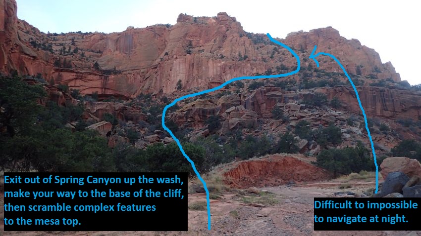
About 750 feet farther a drainage joins Spring Canyon from the
LUC (south) side. This is where you begin the scramble exit out of
Spring Canyon up to Meeks Mesa. Looking up and this drainage and a
bit left the scramble out route can be seen.
 This is what will show as the caption. It can be as long or short as you like.
The text will wrap and the border will expand down to accommodate.
This is what will show as the caption. It can be as long or short as you like.
The text will wrap and the border will expand down to accommodate.
Note:
From Spring Canyon it is about 0.3 miles and 700 feet of
elevation gain to get up to the top of Meeks Mesa.
Unfortunately there is no easy way to describe the best route up
through the maze of steep dirt and sandstone. Good route finding skills are
required to navigate the scrambling / upclimbing route to the mesa
top.
Walk south up the drainage a little over 200 feet to boulder debris
(wPandoraRP-23). Scramble up the boulder debris and at the
same time contour up the right (west) side making your way up the
slope to the west.
About 200 feet up, the slope turns from mostly boulders to a steep
mostly dirt slope (wPandoraRP-24). Continue west contouring across
the slope for about 500 feet. When it begins to feel like the route
is cresting out, veer left (southwest) toward the base of the cliff.
Path gets to the base of the steep cliff band (wPandoraRP-25) and
turns to all slick rock and boulders to scramble, upclimb and
navigate through. At this spot look for a ramp / crack running up
the north to begin the scrambling portion of the route. You may find
cairns along the way but do not count on them being there.
This is the challenging portion of the mesa exit route, good luck
and have fun.
Note:
From this point you are about 450 feet from the top out
of the mesa with about 340 feet of elevation gain to go.
After
topping out on Meeks Mesa (wPandoraRP-26), route-find
due south for 1 mile back to sunrise point where you will follow
down the cattle trail used on approach down off the mesa and back to
your car.
A compass or GPS is
helpful to keep you headed in the right direction toward sunrise
point. Please stay off the crypto!
About 0.3 miles across the mesa you will be crossing over the drainage (wPandoraRP-27) leading
down to the Right Fork of Pandora’s Box. The drainage is so wide and open over
the rolling desert here that you may not even realize you are
crossing over a drainage at all.
Another 0.2 miles south, you will be
crossing over the drainage (wPandoraRP-28) leading down to the Left
Fork of Pandora’s Box. This drainage is also wide open in the
rolling desert and will likely go un-noticed. If you happen to be a
few hundred feet too far to the left (east), the drainage will be a
bit deeper and definitely noticeable.
Continue south another 0.4
miles south across the mesa to where the Meeks Mesa Trail starts
back down the approach ravine (tMeekTrailTop). The start down the
trail is a little difficult to find. Your sense of direction seems
to naturally lead you over to the cliff edge before reaching the
trail. If you get to the cliff edge and do not find the trail, you
likely need to walk along the rim a couple hundred feet farther
south than you expected.
From the top of the Meeks Mesa Trail (tMeekTrailTop),
follow the trail back down the ravine and around the large bench /
ledge about 2.2 miles back to the parking spot and your vehicle.
Downloadable GPX files
available at
BG-Gear Store
(easier than manual entry and a great way to support
Bluugnome).
Waypoint naming convention and map symbol information can be found on the Glossary page.
Elevations are approximate.
BEFORE
manually entering coordinates set your system to WGS84 datum and Lat/Lon hddd.ddddd° coordinate format.
Inconsistent datum's and coordinate formats will result in location errors.
Click to show / expand the list of waypoints below........
| Pandora 1 - Drive to Trailhead |
- extPandora
Lat/Lon (WGS84): N 38.32618
W -111.36428
Elev: NaN Feet
Turn off for the Pandora's Box route. This is a dirt road into a wide open flat area that is comonly used to camp.
- pkPandora
Lat/Lon (WGS84): N 38.32778
W -111.36547
Elev: 6,515 Feet
Start of the trail up to Pandora's Box from a large wide open parking / camping area just off the highway. Look for and follow a trail leading north up through the hills at the base of the cliff band.
|
| Pandora 2 - Approach |
- pkPandora
Lat/Lon (WGS84): N 38.32778
W -111.36547
Elev: 6,515 Feet
Start of the trail up to Pandora's Box from a large wide open parking / camping area just off the highway. Look for and follow a trail leading north up through the hills at the base of the cliff band.
- wPandoraRP-01
Lat/Lon (WGS84): N 38.32945
W -111.36424
Elev: NaN Feet
Trail weaves through some boulders here. The trail will weave through these boulders and be less noticeable in some spots but is overall easy to follow.
- wPandoraRP-02
Lat/Lon (WGS84): N 38.33019
W -111.36337
Elev: 6,800 Feet
Route tops out on the large wide open bench above the parking area. Turn left (northeast) and walk the very wide bench looking for well used use trails forming. The use trails has a few spots that fade away but is well traveled and easy to follow.
- wPandoraRP-03
Lat/Lon (WGS84): N 38.33699
W -111.37361
Elev: 7,000 Feet
Some very nice and some large pieces of petrified wood along the trail.
- wPandoraRP-04
Lat/Lon (WGS84): N 38.34158
W -111.37612
Elev: 7,100 Feet
Trail gradually sweeps right to travel north along the west end of the cliff band you have been next to.
- wPandoraRP-05
Lat/Lon (WGS84): N 38.34524
W -111.37221
Elev: 7,170 Feet
Trail meets and crosses a small drainage. When you get to the drainage it looks like the trail meets it then goes up or down it. Cross over the drainage and start up the slope on the other side where a faint path can be seen going east up the left side of the large ravine that ramps up to the east to the top of the mesa.
- wPandoraRP-06
Lat/Lon (WGS84): N 38.34395
W -111.37012
Elev: NaN Feet
Start of some switch backs. The switchbacks cut up through sandstone and cross over to the right (southish) side of the ravine and continues up toward the mesa top. As the route traverses and climbs up the ravine from here, the path is a bit more difficult to follow because it travels over slick rock making a well worn path less visible. Keep an eye out for the occasional cairn and remember this is still part of an old cattle trail. It is amazing to think cattle traveled up and down this route. After about 300 feet the trail becomes well defined again and easy to follow.
- tMeekTrailTop
Lat/Lon (WGS84): N 38.34294
W -111.36880
Elev: 7,570 Feet
Top out of the cattle trail up to the top of Meeks Mesa (Sunrise Point). Turn left and route find north-ish across rolling desert on a bearing of 13 degrees true north (not magnetic). There are no landmarks or well defined use trails making a GPS helpful as the tilt of the terrain can lead you off course unknowingly.
Navigation Note:
From the top out on the mesa (Sunrise Point) it is important to stay on course to get to a drainage at the intended location. With there being no landmarks or well defined use trails a GPS or strict navigation by compass can be very useful. If not using GPS or compass you may get to the drainage upstream or downstream of the intended location. Upstream of the intended location the drainage is shallow and may be easily crossed with out knowing it making further navigation difficult.
For a good scenic view take a moment to walk south about 60 feet to where you can see down toward the town of Torrey.
- wPandoraRP-07
Lat/Lon (WGS84): N 38.34920
W -111.36691
Elev: 7,555 Feet
Approach route crosses a drainage that runs down to the right (east). To continue to the right fork of Pandora's Box cross over the drainage and continue north. Following east down this drainage will lead to the left fork of Pandora’s Box.
- wPandoraRP-08
Lat/Lon (WGS84): N 38.35133
W -111.36600
Elev: 7,513 Feet
In the drainage leading down to right fork of Pandora's Box. Turn right and travel east down this drainage. Depending on where you dropped into this drainage you may encounter a couple drops in the wash of about 10 feet each to scramble down. About 1000 feet down the drainage the slickrock slot begins to form at the head of the right (north) fork.
- yPandoraRF-Tp
Lat/Lon (WGS84): N 38.35200
W -111.36269
Elev: 7,412 Feet
Head of the right (north) fork of Pandora's Box where a deep slot begins to form. To drop in do not follow down into the slot. Instead walk along the RDC (south) side for about 450 feet to where you can easily scramble down into the canyon just downstream of a tree.
- wPandoraRP-09
Lat/Lon (WGS84): N 38.35177
W -111.36116
Elev: 7,385 Feet
Top entry for the Right Fork of Pandora's Box. This is a shallow easy spot to walk down into the drainage just before it gets deep and narrow. Just down canyon of the entry is an easy down climb of about 15 feet in a narrow slot to a series of two potholes, each about waist deep if full, with a short narrow slot between them. On the other side of the second pool is rap 1.
|
| Pandora 3 - The Canyon |
- wPandoraRP-09
Lat/Lon (WGS84): N 38.35177
W -111.36116
Elev: 7,385 Feet
Top entry for the Right Fork of Pandora's Box. This is a shallow easy spot to walk down into the drainage just before it gets deep and narrow. Just down canyon of the entry is an easy down climb of about 15 feet in a narrow slot to a series of two potholes, each about waist deep if full, with a short narrow slot between them. On the other side of the second pool is rap 1.
- dPandoraR1-3
Lat/Lon (WGS84): N 38.35161
W -111.36041
Elev: NaN Feet
Raps 1 - 3, Pandora's Box.
Rap 1 anchored from a log jammed between the walls and drops about 65 feet down a mostly vertical wall in a narrow chute. After rap 1 is a pothole that can be waist deep if full then a sloped downclimb of about 10 feet to a small sand filled pothole with rap 2 on the other side.
Rap 2 anchored from a log wedged between the walls about 20 feet back and drops about 40 feet down a mostly vertical wall with an awkward over hanging start.. Extending the anchor webbing for rap 2 will reduce rope grooving but also make the start of the rap more awkward. An extended anchor with the rap ring jut over the edge and a courtesy loop can be a good solution here.
Rap 3 is about 40 feet down canyon of rap 2, is anchored from a dead man anchor about 15 feet back and drops about 30 feet down a sloped wall.
About 40 feet after rap 3 the walls become skinny where you will need to stem / climb up about 10 feet off the deck over choke stones. On the other side of the choke stones is a drop of of 15 to 20 feet that can be downclimbed elevator style but will be difficult as the RDC wall flares. Optionally a handline can be set from one of the choke stones to aid in the downclimb.
About 50 feet down canyon between narrow walls is a downclimb of about 25 feet down a deep, dark, narrow twisted flute. Just after is one more downclimb of about 10 feet followed by a tight section about 20 feet long where most people will need to stem up about 15 feet off the deck to get over. About 50 feet farther the canyon opens up.
.
- wPandoraRP-10
Lat/Lon (WGS84): N 38.35149
W -111.35994
Elev: NaN Feet
Canyon opens up. Walk down the wide canyon about 450 feet to a rock boulder debris area on the LDC (north) side.
- wPandoraRP-11
Lat/Lon (WGS84): N 38.35123
W -111.35835
Elev: NaN Feet
Boulder debris area, stay to the LDC (north) side where you can scramble / downclimb the rock pile then down a narrow chimney downclimb of about 10 feet next to the LDC wall. From the bottom of the boulder debris area, walk down canyon about about 100 feet to ravine / ramp going up the RDC side where you can decide to go through or bypass the optional high stemming slot.
Note:
Optionally you can bypass the boulder debris area on the RDC side to an optional rappel of about 35 feet to the bottom of the boulder debris area. Downclimbing through the boulders is faster, easier and more fun than setting up the optional rappel.
- wPandoraRP-12
Lat/Lon (WGS84): N 38.35114
W -111.35800
Elev: NaN Feet
Bottom of the ravine / ramp going up the RDC side where you can decide to go through or bypass the optional high stemming slot about 350 feet long. Continuing down the water course the canyon becomes too skinny for on the ground travel. The first 100 feet will require most people to stem up about 20 feet off the deck. The remaining 250 feet can be traveled along the floor for small people but larger people will still need to stem over a few tighter parts. After the high stemming slot walk about 250 feet down wide canyon to where the left (south) fork of Pandora's Box joins in from the RDC side.
Note:
To bypass the optional high stemming slot do not continue down canyon past the ravine / ramp. Instead scramble / climb up the ravine to get to a large shelf on the RDC side of the canyon. When you get up to the shelf stay to the far right over to the top of a ravine that can be scrambled down into the wide open wash of the left (south) fork of Pandora's Box.
- jPandoraLF-RF
Lat/Lon (WGS84): N 38.35078
W -111.35564
Elev: 7,120 Feet
Confluence of the Left and Right Forks of Pandora's Box. Walk down the wide wash about 0.25 the start of another narrow section.
- wPandoraRP-13
Lat/Lon (WGS84): N 38.34962
W -111.35140
Elev: NaN Feet
Start of another narrow section that is only about 50 feet long with a log jam at the entry to climb over. After the short narrow slot walk open flat sand for about 400 feet passing a large ravine / drainage on the LDC side and down to the start of another narrows just after another side drainage on the RDC side.
- wPandoraRP-14
Lat/Lon (WGS84): N 38.35011
W -111.35027
Elev: 7,053 Feet
Start of another narrow slot where near the start you will need to stem up to walk over the top of some log debris then to a very photogenic subway like area. Part way into the subway like feature, down climb / chimney about 15 feet down into the tight slot below to get to the top of rap 4.
- dPandoraR4
Lat/Lon (WGS84): N 38.35038
W -111.34989
Elev: NaN Feet
Rap 4 - Pandora's Box. A nchored from a choice of logs or choke stones 15 feet back and drops about 30 feet from the anchor down a mostly vertical slot. Getting down to the top of the rap is awkward since it is about 15 feet down into a tight crack. Larger people should not be first or last here as they will have trouble reaching the anchor or rope due to tight quarters. The start of the rap is very awkward and it may be a good idea to lower packs if possible.
From the bottom of rap 4 walk a sandy floor to between narrow walls with one spot where most people will need to stem up about 10 feet and galumph down canyon about 30 feet over a skinny spot. Over the next 500 feet the canyon is a series of narrow / skinny sections and short wide spots.
- wPandoraRP-15
Lat/Lon (WGS84): N 38.35115
W -111.34812
Elev: NaN Feet
Downclimb of 8 to 10 feet into a chamber like area near the end of a very skinny section a couple hundred feet long, Large people may have some issues with this skinny downclimb. In full water conditions the water at the bottom of the chamber will be a swim for about 30 feet to an easy sandy exit to short wide sandy section with a large side ravine on the LDC side.
Just past the large RDC side ravine is another narrows about 100 feet long with easy sand walking between shoulder width walls to another short wide sandy area with smaller cross joints on both sides.
- wPandoraRP-16
Lat/Lon (WGS84): N 38.35165
W -111.34786
Elev: NaN Feet
Start of kinny section with a drop of about 15 feet shortly after entering the slot. This drop is easily downclimbed for all but the last 5 feet where assistance is helpful. A fixed webbing handline can be set using a choke stone at the top of the drop and used to handline / downclimb the drop. The first person down can assist the remainder with the final 5 feet. Optionally this drop can be rappelled but would be very awkward as it is very skinny. At the bottom of this drop the canyon is deep but wider and in full water conditions will be a pool almost waist deep.
Note / Warning:
Large barrel chested people will not fit down this skinny down climb. Large people will need to stem up over this drop and stem down canyon about 25 feet beyond this drop to where they can stem back down to the canyon floor. Stemming up and over will require stemming about 35 feet off the deck.
The next 500 feet of canyon is about 300 feet of fun twisting narrow walls where there is one spot most people will need to stem up about 6 feet to get over a skinny spot about 15 feet long then a wide corridor about 200 feet long to walk.
- wPandoraRP-17
Lat/Lon (WGS84): N 38.35190
W -111.34616
Elev: NaN Feet
Start of another narrow section after a long corridor. This narrow section is a little over 300 feet long but has a few surprises. The walls are a little more twisty, wavy and tighter. Larger people will fit ok but be significantly slower than smaller people.
This narrow section can have waist deep water in full conditions and has 3 downclimbs of 5 to 8 feet each that all are best done as partner assists. You may find anchor webbing on logs at these drops. However the rope is best used as a handline to assist with downclimbing since rappelling these short skinny drops would be more awkward and than downclimbing. A couple of the downclimbs are difficult due to the very skinny start. At the end of this narrow section is rap 5 that drops down into a large subway like feature.
- dPandoraR5
Lat/Lon (WGS84): N 38.35172
W -111.34506
Elev: NaN Feet
Rap 5 - Pandoras Box. At the end of a long narrow section, anchored from a log and drops about 8 feet into a wide subway like section. Starting over the rap can be extremely awkward rather it is rappelled or downclimbed due to the geometry of the skinny crack leading to the overhanging drop. Optionally this drop can also be downclimbed but a partner assist is recommended due to the awkwardness. At the bottom of rap 5 is a short large subway like chamber and the canyon opens up briefly again.
Note:
The skinny slot above the drop forms a tight S curve that can easily trap and or break an arm during a downclimb. Be very cautious if downclimbing this drop.
- dPandoraR6-7
Lat/Lon (WGS84): N 38.35167
W -111.34426
Elev: 6,950 Feet
Raps 6 and 7 - Pandora's Box.
Rap 6, anchored from a small tree / bush about 8 feet overhead on the RDC side and drops about 50 feet down a slot along a vertical wall.
Rap 7 is right at the bottom of rap 6, is anchored from from a flake on the LDC side and a rock embedded in the floor and drops about 150 feet down a mostly vertical wall with a ledge part way down. The 150 feet of rope will get you down to a ledge 20 feet from the bottom where you can walk around to the bottom. If you have more rope you can rappel the additional 20 feet to the canyon floor and not need to scramble around.
After rap 7 is wide canyon full of huge boulders to scramble over and through for about 700 feet to where the boulders fade away.
Note:
There are multiple features and cracks that can catch your rope during the pull. Pay close attention to rope placement, keep twists out of the rope and rappel single strand. A pull line longer than 150 feet may also be helpful so you can step back far enough to get a better angle for the pull.
- wPandoraRP-18
Lat/Lon (WGS84): N 38.35152
W -111.34182
Elev: NaN Feet
Boulders fade away and the canyon turns left to travel north toward Spring Canyon.
Continue north for about 0.2 miles to get to the end of the Pandora’s Box drainage where it dumps into Spring Canyon.
- yPandoraBt
Lat/Lon (WGS84): N 38.35468
W -111.34013
Elev: 6,550 Feet
Bottom exit of Pandora's Box where it dumps into Spring Canyon.
|
| Pandora 4 - Downstream Exit |
- yPandoraBt
Lat/Lon (WGS84): N 38.35468
W -111.34013
Elev: 6,550 Feet
Bottom exit of Pandora's Box where it dumps into Spring Canyon.
- jChimney-Spng
Lat/Lon (WGS84): N 38.32428
W -111.26421
Elev: NaN Feet
Junction where Chimney Rock Canyon meets Spring Canyon. The Chimeny Rock Trailhead is about 2.8 miles west of here up Chimney Rock Canyon.
- tChimneyRock
Lat/Lon (WGS84): N 38.31570
W -111.30397
Elev: 6,055 Feet
Chimeny Rock Trailhead. Paved parking and a pit toilet.
|
| Pandora 5 - Upstream Exit |
- yPandoraBt
Lat/Lon (WGS84): N 38.35468
W -111.34013
Elev: 6,550 Feet
Bottom exit of Pandora's Box where it dumps into Spring Canyon.
- wPandoraRP-20
Lat/Lon (WGS84): N 38.35814
W -111.35171
Elev: 6,640 Feet
Dry fall which is easily bypassed on either side.
- wPandoraRP-21
Lat/Lon (WGS84): N 38.35763
W -111.35432
Elev: NaN Feet
Lower end of a sandstone slot about 350 feet long that is easily bypassed on the LUC/RDC (south) side. About 250 feet up stream of this slot is a drop of about 15 feet to walk around.
- wPandoraRP-22
Lat/Lon (WGS84): N 38.35991
W -111.36234
Elev: 6,760 Feet
Drainage joins in from RUC (north) and drops down from a large obvious inset in the canyon wall on the right (north) side. This is the first obvious inset / drainage on the north wall as you walk up from Pandora's Box and is about 750 feet down stream of scramble exit up to Meeks Mesa begins.
- jPandoraExit
Lat/Lon (WGS84): N 38.35932
W -111.36457
Elev: 6,780 Feet
Drainage joins Spring Canyon from the LUC (south) side. This is where you begin the scramble exit out of Spring Canyon up to Meeks Mesa. Walk south up the drainage a little over 200 feet to boulder debris.
Note:
From Spring Canyon it is about 0.3 miles and 700 feet of elevation gain to get up to the top of Meeks Mesa. Unfortunately there is no easy way to describe the best route up through the maze of steep dirt and sandstone. Good route finding skills are required to navigate the scrambling / upclimbing route to the mesa top.
- wPandoraRP-23
Lat/Lon (WGS84): N 38.35880
W -111.36494
Elev: NaN Feet
Start of a boulder debris area. Scramble up the boulder debris and at the same time contour up the right (west) side making your way up the slope to the west.
- wPandoraRP-24
Lat/Lon (WGS84): N 38.35835
W -111.36537
Elev: 6,890 Feet
About 200 feet up, the slope turns from mostly boulders to a steep mostly dirt slope. Continue west contouring across the slope for about 500 feet. When it begins to feel like the route is cresting out, veer left (southwest) toward the base of the cliff.
- wPandoraRP-25
Lat/Lon (WGS84): N 38.35795
W -111.36744
Elev: NaN Feet
Path gets to the base of the steep cliff band and turns to all slick rock and boulders to scramble, upclimb and navigate through. At this spot look for a ramp / crack running up the north to begin the scrambling portion of the route. You may find cairns along the way but do not count on them being there. This is the challenging portion of the mesa exit route, good luck and have fun.
Note:
From this point you are about 450 feet from the top out of the mesa with about 340 feet of elevation gain to go.
- wPandoraRP-26
Lat/Lon (WGS84): N 38.35671
W -111.36769
Elev: 7,485 Feet
Top out on Meeks Mesa after climbing up out of Spring Canyon. Route-find due south for 1 mile back to sunrise point where you will follow down the cattle trail used on approach down off the mesa and back to your car. A compass or GPS is helpful to keep you headed in the right direction toward sunrise point. Please stay off the crypto!
- wPandoraRP-27
Lat/Lon (WGS84): N 38.35212
W -111.36901
Elev: 7,640 Feet
Exit crosses over the drainage (wPandoraRP-27) leading down to the Right Fork of Pandora’s Box. The drainage is so wide and open over the rolling desert here that you may not even realize you are crossing over a drainage at all.
- wPandoraRP-28
Lat/Lon (WGS84): N 38.34867
W -111.36869
Elev: NaN Feet
Exit route crosses over the drainage leading down to the Left Fork of Pandora's Box. Depending on the bearing you traveled, the drainage will likely be wide over rolling desert and likely go un-noticed.
- tMeekTrailTop
Lat/Lon (WGS84): N 38.34294
W -111.36880
Elev: 7,570 Feet
Top out of the cattle trail up to the top of Meeks Mesa (Sunrise Point). Turn left and route find north-ish across rolling desert on a bearing of 13 degrees true north (not magnetic). There are no landmarks or well defined use trails making a GPS helpful as the tilt of the terrain can lead you off course unknowingly.
Navigation Note:
From the top out on the mesa (Sunrise Point) it is important to stay on course to get to a drainage at the intended location. With there being no landmarks or well defined use trails a GPS or strict navigation by compass can be very useful. If not using GPS or compass you may get to the drainage upstream or downstream of the intended location. Upstream of the intended location the drainage is shallow and may be easily crossed with out knowing it making further navigation difficult.
For a good scenic view take a moment to walk south about 60 feet to where you can see down toward the town of Torrey.
- wPandoraRP-06
Lat/Lon (WGS84): N 38.34395
W -111.37012
Elev: NaN Feet
Start of some switch backs. The switchbacks cut up through sandstone and cross over to the right (southish) side of the ravine and continues up toward the mesa top. As the route traverses and climbs up the ravine from here, the path is a bit more difficult to follow because it travels over slick rock making a well worn path less visible. Keep an eye out for the occasional cairn and remember this is still part of an old cattle trail. It is amazing to think cattle traveled up and down this route. After about 300 feet the trail becomes well defined again and easy to follow.
- wPandoraRP-05
Lat/Lon (WGS84): N 38.34524
W -111.37221
Elev: 7,170 Feet
Trail meets and crosses a small drainage. When you get to the drainage it looks like the trail meets it then goes up or down it. Cross over the drainage and start up the slope on the other side where a faint path can be seen going east up the left side of the large ravine that ramps up to the east to the top of the mesa.
- wPandoraRP-04
Lat/Lon (WGS84): N 38.34158
W -111.37612
Elev: 7,100 Feet
Trail gradually sweeps right to travel north along the west end of the cliff band you have been next to.
- wPandoraRP-03
Lat/Lon (WGS84): N 38.33699
W -111.37361
Elev: 7,000 Feet
Some very nice and some large pieces of petrified wood along the trail.
- wPandoraRP-02
Lat/Lon (WGS84): N 38.33019
W -111.36337
Elev: 6,800 Feet
Route tops out on the large wide open bench above the parking area. Turn left (northeast) and walk the very wide bench looking for well used use trails forming. The use trails has a few spots that fade away but is well traveled and easy to follow.
- wPandoraRP-01
Lat/Lon (WGS84): N 38.32945
W -111.36424
Elev: NaN Feet
Trail weaves through some boulders here. The trail will weave through these boulders and be less noticeable in some spots but is overall easy to follow.
- pkPandora
Lat/Lon (WGS84): N 38.32778
W -111.36547
Elev: 6,515 Feet
Start of the trail up to Pandora's Box from a large wide open parking / camping area just off the highway. Look for and follow a trail leading north up through the hills at the base of the cliff band.
|