Canyoneering Route Description
A-Door-Able Canyon - 3A III (IV)
Capitol Reef National Park, Utah
09-18-16, 4 people, 1 Day (Travel time in route 5.5 hours)
 Camp to camp in Spring Canyon
Time Required - 8 to 9 hours car to car. or 5
to 6 hours camp to camp if camped in spring canyon
Distance - 9 miles Total, 0.3 miles Technical
Rappels - 4 Rappels, Longest Rappel 280 feet.
Final rap is longest and webbing must be extended to make length
only 280 feet.
Elevation Range - 5920 - 6610 Feet
Shuttle Required - No
Vehicle - Passenger
Permit Required - Yes
Rappelling and anchor gear, Ropes and or pull cords for rappels up
to 280 feet and 70 feet of 1 inch webbing for sling placement.
Wet suits may be needed in cooler months and after recent rains
filling a few short sections.
A-Door-Able Canyon is a unique canyon with a few unique
features worth the visit! The door in the canyon is like no other feature
I have come across.
There are a few small portions of A-Door-Able Canyon
that can hold water forcing swims or chest deep wades. On our visit we were
able to avoid all water but it looks like there will be times in this canyon
where that is not possible.
The approach to A-Door-Able Canyon is off the beaten
path with little signs of previous passage. A GPS or good map reading skills
are required for this route. Thanks to John D. for inviting us to join in
on checking this place out.
On the exit down Spring Canyon you will need to turn
and go up Chimney Rock Canyon back to highway 24. It is worth
mentioning that it can be easy to pass this junction even though it is
marked with a wooden sign. If you mistakenly pass the junction you would be
walking for many miles before reaching a road or well traveled area. Be
alert during the exit and be sure to go up Chimney Rock Canyon.
On our visit in 2016 we bypassed the first 60 feet of
canyon by scrambling to the canyon floor down a rock nose then shortly down
canyon we came across a deep, wide silo with a 20 foot drop right on the
other side. We decided to scramble back up to the rim and go down canyon to
rap in beyond the silo which is about 230 feet down canyon from the head. At
the bottom of rap 1 from the rim you will be just down canyon of a huge
doorway just up canyon. This huge doorway is a hole that has blown out of
the down canyon end of a massively deep pothole. You can walk up and into
the doorway for a scenic treat unlike any I have encountered. This very
unique feature is the name sake of A-Door-Able Canyon. While trying to come
up with names for the place Tracy Kwan mentioned A-Door-Able and we all
instantly loved it.
To get to the Trailhead
From the junction of highways 12 and 24, drive east on highway
24 toward Capitol Reef for 6.8 miles to a turn off on the left
for Chimney Rock Trail.
OR
From the visitor center in Capitol Reef, drive 3 miles east on
highway 24 to a turn off on the right for Chimney Rock Trail.
The turn off is paved and runs a couple hundred feet to the
parking area at the Chimney Rock Trailhead (tChimneyRock).
To leave the Exit Vehicle / Escape Pod
No exit vehicle is needed. This is done as a loop route.
GPS coordinate information listed at the bottom. For information about waypoint naming and map symbols, refer to the
Glossary page.

Click the links for maps of the route.
Map of the entire route.
Map zoomed in.
Map of the technical section.
The Approach:
From the parking lot (tChimneyRock)
follow the Chimney Rock
trail northeast about
150 feet to where a
small trail branches off
(wSmokStakRP-01) to the
left (northwest).
To go to Stone Dagger or
A-Door-Able canyons,
continue northeast on
the main trail.
About 0.5 miles down the
trail is a trail
junction (jChim-Sprg-cyn)
on the Chimney Rock Loop
Trail. To go to
Stone Dagger or
A-Door-Able canyons
follow the trail
northeast and not the
trail to the south
leading to Chimney Rock.
About 350 feet east the
trail will cross a
drainage then continue
east and roughly follow
along a drainage below
also going east.
About 0.9 miles farther
is a spot on the Chimney
Rock Loop Trail where
use trails leave
(jChim-SprgCyn2) the
main trail and drop
north down into the
large drainage about 90
feet away. To go
to Stone Dagger or
A-Door-Able Canyons,
leave the main trail and
follow use trails about
90 feet down into the
major drainage below.
Once in the main
drainage below
(wSmokStakRP-21)
continue east down the
wash.
About 0.27 miles farther
a large side canyon
joins in from the north
(wSmokStakRP-20).
Continue east down the
wash.
About 0.55 miles farther
is the bottom exit of
Smokestack Canyon (ySmokStak-Bt)
on the left (northish),
continue east in the
wash.
About 0.3 miles farther
a side canyon joins in
(ChimRkCyn30) from the
north with two large
cottonwood trees just
west of where the side
canyon joins in.
Continue east down the
wash.
About 0.3 miles farther
is a confluence where
Chimney Rock Canyon
meets Spring Canyon with
wooden signs posted.
To go to Stone Dagger or
A-Door-Able canyons go
north up Spring Canyon.
About 0.5 miles north up
Spring Canyon is a large
drainage (jA-Door-Able)
on the right (northeast)
side of Spring Canyon.
Leave Spring Canyon and
go northeast up this
large drainage.
About 250 feet up the
drainage is the bottom
of a rubble filled
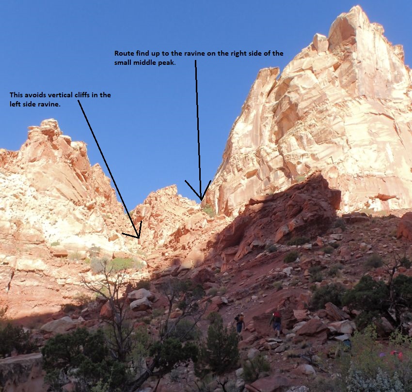
ravine (A-Door01)
leaving the drainage
going up to the
northwest. Note a small
peak in the center of
the ravine and routefind
up the slopes to the
right of that peak. As
you get higher up the
slopes, you will be
going into a smaller
ravine going up the
right side of the center
peak. There are a couple
spots with exposed 4th
class scrambling for a
short distance.
 Note a small
peak in the center of the ravine and routefind up the slopes to the right of
that peak. As you get higher up the slopes, you will be going into a smaller
ravine going up the right side of the center peak. There are a couple spots with
exposed 4th class scrambling for a short distance.
Note a small
peak in the center of the ravine and routefind up the slopes to the right of
that peak. As you get higher up the slopes, you will be going into a smaller
ravine going up the right side of the center peak. There are a couple spots with
exposed 4th class scrambling for a short distance.
Shortly up the slopes on the right of
the ravine the rock gets steeper (A-Door02) requiring more hands and feet
in places. Staying far right seems to be the best route but effort is required
to route find through this convoluted area. There is one spot you will need to
climb 4th class up about 10 feet to continue up.
A few hundred feet farther
is the top out of the small
ravine (A-Door03) on the
right of the peak. Veer left
and scramble down steep
slickrock to the main ravine
below.
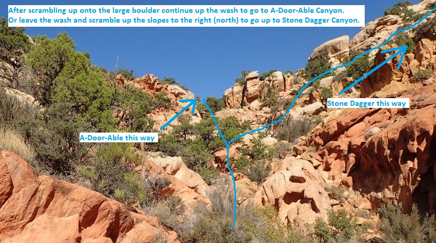
Once down in the main ravine
(A-Door04), scramble and
boulder hop northwest up the
ravine.
About 500 feet farther up
the ravine is a very large
boulder in the ravine with
ledges on the left to help
scramble up over it. From
the top of the boulder
(A-Door05) you can see the
ravine is getting wider and
the grade becomes more
gentle.
To go to A-Door-Able Canyon
continue northwest up the
wash about 375 feet to a
brief top out in the ravine.
Note:
If
you were going to Stone
Dagger Canyon you would
continue northwest about 150
feet farther up the ravine
then leave the ravine to the
right (north) scrambling up
a series of ledges.
 To continue to
A-Door-Able Canyon continue northwest up the wash about 375 feet to a brief top
out in the ravine.
To continue to
A-Door-Able Canyon continue northwest up the wash about 375 feet to a brief top
out in the ravine.
Once at the brief top
out of the ravine
(A-Door06), continue
northwest about 500 feet
down then up to the next
high point.
At the next highest
point (A-Door07),
continue northwest about
300 feet down to a wide
where a couple drainages
come together.
At the wide confluence
(A-Door08), continue up
the wash up to the
northwest.
About 750 feet farther
the wash begins to get
steep (A-Door09).
Scramble up steep
slickrock on the right
(northeast) side.
About 500 feet farther
is a wide saddle
(A-Door10Sdle). Drop
down to the northwest to
the drainage below.
About 300 feet down the
wash scramble up to the
shelf (A-Door11) on the
left (southwest) side.
Once on the shelf
continue northwest
roughly following the
drainage for about 400
feet.
As the shelf you are
following widens
(A-Door12) and where you
can turn left and
contour around to the
west toward A-Door-Able
Canyon. Continue west
following down a minor
drainage beginning to
form.
About 600 feet farther
the minor drainage meets
(A-Door13) a larger
drainage. Turn left and
follow the wash down to
the west.
About 200 feet farther
is a pour off with a few
potholes (A-Door14)
where you can easily
scramble down into the
larger drainage below.
Follow southish down the
large drainage a
vegetated section near a
confluence.
At short vegetated
section (A-Door15Veg) by
a confluence continue
down canyon in sandy
wash walking.
About 150 feet farther
is the head of
A-Door-Able Canyon (yA-Door-AbleTp)
where a slot forms.
The Canyoneering / Technical Section:
From the head
where the slot forms (yA-Door-AbleTp)
is a drop of about 25
feet. To get to rap 1
walk the RDC rim about
230 feet down canyon
where you can rap from a
rock to the canyon
floor.
Note:
On our visit in 2016
we bypassed the first 60
feet of canyon by
scrambling to the canyon
floor down a rock nose
next to the crack on the
RDC side. Shortly down
canyon we came across a
deep, wide silo with a
20 foot drop right on
the other side. We
decided to scramble back
up to the rim and go
down canyon to rap in
beyond the silo which is
about 230 feet down
canyon from the head.
If you want you can
easily scramble into the
canyon by going down
steep slope next to a
crack (A-Door16Rim).
Rap 1 (dA-Door-R1) is
anchored from a large
rock on the rim about 30
feet back from the rim
and uses about 100 feet
of rope travel to get
down into the canyon
floor. At the bottom of
the rap go up canyon to
see a very interesting
feature.
At the bottom of rap 1
from the rim is
the lower end of what
was bypassed by walking
the rim to rap 1.
What was bypassed was a
deep wide silo with a 20
foot drop on the other
side to what once was a
monster deep pothole but
the down canyon wall has
blown out creating a
huge door way like
feature. If you rap down
from the rim at rap 1
you will land right
below this door
(A-Door-Able) in the
canyon and can walk up
and into it. This
feature is very unique
and worth the visit.
About 150 feet down
canyon is a drop of
about 15 feet (A-Door17)
that can be done as a
very challenging partner
assist where 2 or 3
people at the bottom is
recommended. The drop
starts with a super
tight crack right at the
top that opens up to
wide open air below with
zero features to
downclimb on. Getting a
few people down with
meat anchor first they
can then walk up the
slopped ramp at the
bottom and reach up to
assist the last person
down. Once at the bottom
look straight up
overhead to see light
coming through an arch.
Shortly down canyon is
skinny section a little
over 100 feet long with
very smooth polished
walls.
At the down canyon end
of the skinny section is
downclimb (A-Door18) of
about 8 feet down a
narrow crack to a pool
below and open corridor
down canyon. Rap 2
is about 160 feet down
canyon.
Rap 2 (dA-Door-R2) is
anchored from an arch
low on the LDC side and
drops about 15 feet to
more sandy corridor to
walk for about 250 feet
with one pinch to
galumph over along the
way.
About 250 feet down
canyon is the start of
(A-Door19) a deep skinny
section with an easy
downclimb of 6 to 8 feet
under log debris.
Continue through the
skinny section about 50
feet to the next rap.
Rap 3 (dA-Door-R3) is
anchored from log wedged
between the walls and
drops 8 to 10 feet which
could also be partner
assisted. Optionally the
drop can be anchored
using log debris about
50 feet back.
Just after the rap is a
pool that would be a
swimmer of about 25 feet
long if full. We were
able to climb log debris
to get over the pool.
Just after is a brief
open spot.
Just after the open spot
is a drop (A-Door20) of
about 8 feet that can
easily be partner
assisted just after a
brief open spot.
The final rap is about
150 feet down canyon.
Rap 4 (dA-Door-R4) is
anchored from deadman
anchor in the last
pothole before the drop
and drops about 280
feet. The 280 feet is
with extending the
anchor webbing as far
out as comfortable. If
anchor material flashes
out with flooding you
may need to farm rocks
from up canyon like we
did.
Walk about 450 feet out
to the end of the
drainage where it dumps
into Spring Canyon (yA-Door-AbleBt).
The Exit:
Once in
Spring Canyon (yA-Door-AbleBt)
turn left and walk
southwest then south
down Spring canyon about
1.5 miles to the
confluence where Chimney
Rock Canyon meets Spring
Canyon with wooden signs
posted (jChimney-Spng). Go west
up Chimney Rock Canyon.
Warning:
When exiting from Stone
Dagger, A-Door-Able, or Pandoras
Box Canyons, it is easy
to walk right by this
junction on the hike out
and accidentally
continue walking
aimlessly south down
Spring Canyon. Even with
the wooded signs posted
I have seen people just
walk by and never see
the sign.
About 1.4 miles up
Chimney Rock Canyon a
use trail goes up out of
the drainage and up to
the trail above
(wSmokStakRP-21).
Walk up use trails to
the main trail on the
south side of the wash.
Once on the main trail
(jChim-SprgCyn2) follow
the trail west about 0.8
miles to a trail
junction.
From the trail junction
(jChim-SprgCyn1) follow
the trail going west
about 0.5 miles to the
Chimney Rock Parking
area (tChimneyRock).
Downloadable GPX files
available at
BG-Gear Store
(easier than manual entry and a great way to support
Bluugnome).
Waypoint naming convention and map symbol information can be found on the Glossary page.
Elevations are approximate.
BEFORE
manually entering coordinates set your system to WGS84 datum and Lat/Lon hddd.ddddd° coordinate format.
Inconsistent datum's and coordinate formats will result in location errors.
Click to show / expand the list of waypoints below........
| A-Door-Able (1) - Approach |
- tChimneyRock
Lat/Lon (WGS84): N 38.31570
W -111.30397
Elev: 6,055 Feet
Chimeny Rock Trailhead. Paved parking and a pit toilet.
- wSmokStakRP-01
Lat/Lon (WGS84): N 38.31602
W -111.30372
Elev: NaN Feet
Small trail branches off to the left (northwest).
To go to the top of Smokestck Canyon, leave the main trail and walk northwest following the smaller trail over to a draiange about 400 feet away.
To go to Stone Dagger or A-Door-Able canyons, continue northeast on the main trail.
- jChim-SprgCyn1
Lat/Lon (WGS84): N 38.31756
W -111.29826
Elev: 6,300 Feet
Trail junction on the Chimney Rock Loop Trail.
To go to Stone Dagger or A-Door-Able canyons follow the trail northeast and not the trail to the south leading to Chimney Rock. About 350 feet east the trail will cross a drainage then continue east and roughly follow along a drainage below also going east.
On the hike back out to the parking area Follow the trail west about 0.5 miles back to the parking lot.
- wSmokStakRP-21
Lat/Lon (WGS84): N 38.31766
W -111.28491
Elev: NaN Feet
Use trail goes up out of the draianage and up to the trail above.
To go to Stone Dagger or A-Door-Able canyons continue east down the wash.
To go to the Chimney Rock parking area walk up use trails to the main trail on the south side of the wash.
- wSmokStakRP-20
Lat/Lon (WGS84): N 38.31922
W -111.28163
Elev: NaN Feet
Large side canyon joins in from the north. To got to Stone Dagger or A-Door-Able canyons continue east in the wash.
- ySmokStak-Bt
Lat/Lon (WGS84): N 38.32288
W -111.27389
Elev: 6,000 Feet
Bottom exit of Smokestack Canyon where it dumps into Chimney Rock Canyon.
To go to the Chimney Rock parking area turn right (south) and walk up stream in Chimney Rock Canyon.
To go to Stone Dagger or A-Door-Able canyons continue east in the wash.
- ChimRkCyn30
Lat/Lon (WGS84): N 38.32407
W -111.26967
Elev: NaN Feet
Side canyon joins in from the north with two large cottonwood trees just west of where the side canyon joins in.
- jChimney-Spng
Lat/Lon (WGS84): N 38.32428
W -111.26421
Elev: 5,920 Feet
Confluence where Chimney Rock Canyon meets Spring Canyon with wooden signs posted.
To go to Stone Dagger or A-Door-Able canyons go north up Spring Canyon.
To go to the Chimney Rock parking area go west up Chimney Rock Canyon.
Warning: when exiting from Stone Dagger, A-Door-Able, or Pandoras Box Canyons, it is easy to walk right by this junction on the hike out and accidentally continue walking aimlessly south down Spring Canyon. Even with the wooded signs posted I have seen people just walk by and never see the sign.
- jA-Door-Able
Lat/Lon (WGS84): N 38.33168
W -111.26385
Elev: NaN Feet
Large drainage on the northeast side of Spring Canyon. To go to A-Door-Able or Stone Dagger Canyons go northeast up this large drainage.
To go to the Chimney Rock parking area travel south down Spring Canyon.
- A-Door01
Lat/Lon (WGS84): N 38.33233
W -111.26348
Elev: NaN Feet
Bottom of a rubble filled ravine leaving the drainage going up to the northwest. Note a small peak in the center of the ravine and routefind up the slopes to the right of that peak. As you get higher up the slopes, you will be going into a smaller ravine going up the right side of the center peak. There are a couple spots with exposed 4th class scrambling for a short distance.
On exit from Stone Dagger, turn right and walk south about 250 feet back into Spring Canyon.
- A-Door02
Lat/Lon (WGS84): N 38.33272
W -111.26378
Elev: NaN Feet
Rock gets steeper requiring more hands and feet in places. Staying far right seems to be the best route but effort is required to route find through this convoluted area. There is one spot you will need to climb 4th class up about 10 feet to continue up.
- A-Door03
Lat/Lon (WGS84): N 38.33336
W -111.26464
Elev: NaN Feet
Top out of the small ravine on the right of the peak. Veer left and scramble down steep slickrock to the main ravine below.
On exit from Stone Dagger, scramble down the slopes about 500 feet down into a larger drainage with a couple of 4th class scrambles on the way.
- A-Door04
Lat/Lon (WGS84): N 38.33309
W -111.26537
Elev: NaN Feet
Down in the main ravine. Scramble and boulder hop northwest up the ravine.
On exit from Stone Dagger, scramble up to the right (northish) up a boulder filled slope to the top of a side ravine.
- A-Door05
Lat/Lon (WGS84): N 38.33379
W -111.26687
Elev: NaN Feet
A very large boulder in the ravine with ledges on the left to help scramble up over it. From the top of the boulder you can see the ravine is getting wider and the grade becomes more gentle.
To go to Stone Dagger Canyon continue northwest about 150 feet farther up the ravine then leave the ravine to the right (north) scrambling up a series of ledges.
To go to A-Door-Able Canyon continue northwest up the wash about 375 feet to a brief top out in the ravine.
On exit from Stone Dagger, downclimb the boulder and continue down the ravine.
- jStoneDagger
Lat/Lon (WGS84): N 38.33412
W -111.26729
Elev: 6,420 Feet
Leave the drainage and begin routefinding north up a series of ledge. On our visit the route up the ledges had the occasional cairn but they may not remain, so they should not be depended on. On exit, turn left and go southeast down the wash a short distance to a large boulder.
- A-Door06
Lat/Lon (WGS84): N 38.33451
W -111.26782
Elev: NaN Feet
Brief top out of the ravine. Continue northwest about 500 feet down then up to the next high point.
- A-Door07
Lat/Lon (WGS84): N 38.33535
W -111.26933
Elev: 6,545 Feet
Brief top out. Continue northwest about 300 feet down to a wide where a couple drainages come together.
- A-Door08
Lat/Lon (WGS84): N 38.33606
W -111.27003
Elev: NaN Feet
Wide area where a couple drainages cross. Continue up the wash up to the northwest.
- A-Door09
Lat/Lon (WGS84): N 38.33772
W -111.27151
Elev: NaN Feet
Wash begins to get steep. Scramble up steep slickrock on the right (northeast) side.
- A-Door10Sdle
Lat/Lon (WGS84): N 38.33865
W -111.27271
Elev: 6,610 Feet
Wide saddle. Drop down to the northwest to the drainage below.
- A-Door11
Lat/Lon (WGS84): N 38.33911
W -111.27357
Elev: NaN Feet
Instead of following down the wash, scramble up to the shelf on the left (southwest) side. Once on the shelf continue northwest roughly following the drainage for about 400 feet.
- A-Door12
Lat/Lon (WGS84): N 38.33986
W -111.27463
Elev: NaN Feet
Shelf you are following widens and where you can turn left and contour around to the west toward A-Door-Able Canyon. Continue west following down a minor drainage beginning to form.
- A-Door13
Lat/Lon (WGS84): N 38.33989
W -111.27650
Elev: NaN Feet
Minor drainage meets a larger drainage. Turn left and follow the wash down to the west.
- A-Door14
Lat/Lon (WGS84): N 38.33975
W -111.27709
Elev: NaN Feet
Pour off with a few potholes where you can easily scramble down into the larger drainage below. Follow southish down the large drainage.
- A-Door15Veg
Lat/Lon (WGS84): N 38.33961
W -111.27727
Elev: NaN Feet
Short vegetated section by a confluence followed by sandy wash walking.
- yA-Door-AbleTp
Lat/Lon (WGS84): N 38.33932
W -111.27763
Elev: 6,470 Feet
Top of A-Door-Able canyon where a slot forms with a drop of about 25 feet. To get to rap 1 walk the RDC rim about 230 feet down canyon where you can rap from a rock to the canyon floor.
Note: On our visit in 2016 we bypassed the first 60 feet of canyon by scrambling to the canyon floor down a rock nose next to the crack on the RDC side. Shortly down canyon we came across a deep, wide silo with a 20 foot drop right on the other side. We decided to scramble back up to the rim and go down canyon to rap in beyond the silo which is about 230 feet down canyon from the head.
|
| A-Door-Able (2) - The Canyon |
- yA-Door-AbleTp
Lat/Lon (WGS84): N 38.33932
W -111.27763
Elev: 6,470 Feet
Top of A-Door-Able canyon where a slot forms with a drop of about 25 feet. To get to rap 1 walk the RDC rim about 230 feet down canyon where you can rap from a rock to the canyon floor.
Note: On our visit in 2016 we bypassed the first 60 feet of canyon by scrambling to the canyon floor down a rock nose next to the crack on the RDC side. Shortly down canyon we came across a deep, wide silo with a 20 foot drop right on the other side. We decided to scramble back up to the rim and go down canyon to rap in beyond the silo which is about 230 feet down canyon from the head.
- A-Door16Rim
Lat/Lon (WGS84): N 38.33917
W -111.27771
Elev: NaN Feet
Crack to cross over while traveling the RDC rim down to rap 1. Optionally you can scramble down to the canyon floor down a rock nose but if you do you will soon encounter a wide, deep silo with a 20 foot drop on the other side.
- dA-Door-R1
Lat/Lon (WGS84): N 38.33867
W -111.27791
Elev: NaN Feet
Rap 1 - A-Door-Able Canyon. Anchored from a large rock on the rim about 30 feet back from the rim and uses about 100 feet of rope travel to get down into the canyon floor. At the bottom of the rap go up canyon to see a very interesting feature.
- A-Door-Able
Lat/Lon (WGS84): N 38.33876
W -111.27786
Elev: NaN Feet
A deep wide silo with a 20 foot drop on the other side to what once was a monster deep pothole but the down canyon wall has blown out creating a huge door way like feature. If you rap down from the rim at rap 1 you will land right below this door in the canyon and can walk up and into it. This feature is very unique and worth the visit.
- A-Door17
Lat/Lon (WGS84): N 38.33833
W -111.27772
Elev: NaN Feet
Drop of about 15 feet that can be done as a very challenging partner assist where 2 or 3 people at the bottom is recommended. The drop starts with a super tight crack right at the top that opens up to wide open air below with zero features to downclimb on. Getting a few people down with meat anchor first they can then walk up the slopped ramp at the bottom and reach up to assist the last person down. Once at the bottom look straight up overhead to see light coming through an arch.
Shortly down canyon is skinny section a little over 100 feet long with very smooth polished walls.
- A-Door18
Lat/Lon (WGS84): N 38.33802
W -111.27742
Elev: NaN Feet
Down canyon end of a skinny sectionand a downclimb of about 8 feet down a narrow crack to a pool below and open corridor down canyon.
- dA-Door-R2
Lat/Lon (WGS84): N 38.33763
W -111.27719
Elev: NaN Feet
Rap 2 - A-Door-Able Canyon. Anchored from an arch low on the LDC side and drops about 15 feet to more sandy corridor to walk for about 250 feet with one pinch to galumph over along the way.
- A-Door19
Lat/Lon (WGS84): N 38.33704
W -111.27694
Elev: NaN Feet
Start of a deep skinny section with an easy downclimb of 6 to 8 feet under log debris. Continue through the skinny section about 50 feet to the next rap.
- dA-Door-R3
Lat/Lon (WGS84): N 38.33698
W -111.27675
Elev: NaN Feet
Rap 3 - A-Door-Able Canyon. Anchored from log wedged between the walls and drops 8 to 10 feet which could also be partner assisted. Optionally the drop can be anchored using log debris about 50 feet back.
Just after the rap is a pool that would be a swimmer of about 25 feet long if full. We were able to climb log debris to get over the pool. Just after is a brief open spot.
- A-Door20
Lat/Lon (WGS84): N 38.33669
W -111.27661
Elev: NaN Feet
Drop of about 8 feet that can easily be partner assisted just after a brief open spot.
- dA-Door-R4
Lat/Lon (WGS84): N 38.33634
W -111.27681
Elev: NaN Feet
Rap 4 - A-Door-Able Canyon. Anchored from deadman anchor in the last pothole before the drop and drops about 280 feet. The 280 feet is with extending the anchor webbing as far out as comfortable. If anchor material flashes out with flooding you may need to farm rocks from up canyon like we did.
- yA-Door-AbleBt
Lat/Lon (WGS84): N 38.33524
W -111.27760
Elev: 6,035 Feet
Bottom of A-Door-Able Canyon where it dumps into Spring Canyon.
|
| A-Door-Able (3) - Exit |
- yA-Door-AbleBt
Lat/Lon (WGS84): N 38.33524
W -111.27760
Elev: 6,035 Feet
Bottom of A-Door-Able Canyon where it dumps into Spring Canyon.
- jA-Door-Able
Lat/Lon (WGS84): N 38.33168
W -111.26385
Elev: NaN Feet
Large drainage on the northeast side of Spring Canyon. To go to A-Door-Able or Stone Dagger Canyons go northeast up this large drainage.
To go to the Chimney Rock parking area travel south down Spring Canyon.
- jChimney-Spng
Lat/Lon (WGS84): N 38.32428
W -111.26421
Elev: 5,920 Feet
Confluence where Chimney Rock Canyon meets Spring Canyon with wooden signs posted.
To go to Stone Dagger or A-Door-Able canyons go north up Spring Canyon.
To go to the Chimney Rock parking area go west up Chimney Rock Canyon.
Warning: when exiting from Stone Dagger, A-Door-Able, or Pandoras Box Canyons, it is easy to walk right by this junction on the hike out and accidentally continue walking aimlessly south down Spring Canyon. Even with the wooded signs posted I have seen people just walk by and never see the sign.
- ChimRkCyn30
Lat/Lon (WGS84): N 38.32407
W -111.26967
Elev: NaN Feet
Side canyon joins in from the north with two large cottonwood trees just west of where the side canyon joins in.
- ySmokStak-Bt
Lat/Lon (WGS84): N 38.32288
W -111.27389
Elev: 6,000 Feet
Bottom exit of Smokestack Canyon where it dumps into Chimney Rock Canyon.
To go to the Chimney Rock parking area turn right (south) and walk up stream in Chimney Rock Canyon.
To go to Stone Dagger or A-Door-Able canyons continue east in the wash.
- wSmokStakRP-20
Lat/Lon (WGS84): N 38.31922
W -111.28163
Elev: NaN Feet
Large side canyon joins in from the north. To got to Stone Dagger or A-Door-Able canyons continue east in the wash.
- wSmokStakRP-21
Lat/Lon (WGS84): N 38.31766
W -111.28491
Elev: NaN Feet
Use trail goes up out of the draianage and up to the trail above.
To go to Stone Dagger or A-Door-Able canyons continue east down the wash.
To go to the Chimney Rock parking area walk up use trails to the main trail on the south side of the wash.
- jChim-SprgCyn1
Lat/Lon (WGS84): N 38.31756
W -111.29826
Elev: 6,300 Feet
Trail junction on the Chimney Rock Loop Trail.
To go to Stone Dagger or A-Door-Able canyons follow the trail northeast and not the trail to the south leading to Chimney Rock. About 350 feet east the trail will cross a drainage then continue east and roughly follow along a drainage below also going east.
On the hike back out to the parking area Follow the trail west about 0.5 miles back to the parking lot.
- tChimneyRock
Lat/Lon (WGS84): N 38.31570
W -111.30397
Elev: 6,055 Feet
Chimeny Rock Trailhead. Paved parking and a pit toilet.
|