Canyoneering Route Description
Icebox Canyon North Entry - 3B III (IV)
Zion National Park, Utah.
11-04-2007, 3 people, 1 Day (Travel time in route 14.15 hours)

08-13-2016, 5 people, 1 Day (Travel time in route 13.6 hours)
Time Required - 12 to 15 hours
Distance - 13 miles Total, 2.93 miles Technical
Rappels - 7 Rappels, Longest Rappel 150 feet.
Elevation Range - 6960 - 5050 Feet
Shuttle Required -No Vehicle - Passenger
Permit Required - Yes
Rappelling and anchor gear, Ropes and or pull cords for rappels up
to 150 feet and 70 feet of 1 inch webbing for sling placement. Wet
suits should be included in cool temps.
Icebox Canyon is not a technical show piece once down in the canyon
proper but is a scenic show piece! This place is beautiful!
The scenery starts from the view looking down canyon while on the
entry raps. The canyon continues to visually delight all the
way to the end with, streaked walls, trough water falls, colored
walls that look like oil paintings and more. If you like
pretty places you should check out Icebox Canyon.
There are a couple spots where you will likely need to swim (one of
them being about 100 feet long). In warm to moderate temps a
wet suit is not needed as there are only a couple swims and you will
dry quickly. Bring a dry bag though to keep your stuff dry.
With a bit of work you can stem over the long pool and only get wet
to your knees in the entire canyon, but plan on likely swimming.
The North Pass Entry to Icebox canyon starts down a sloped trough
like area which slowly gets more and more steep. There are
bolts placed along the way but the upper stations you will likely
walk past unless there is snow and ice. The raps for the north
pass entry are labeled and written up with the assumption you will
bypass some of these rap stations. With this in mind, realize
your entry rap count may differ if you choose differently.
One of the rappels on the North Entry is more of a hand line to
protect a 90 feet steep slope where you traverse a lot. A fall
here would result in a pendulum tumble. Be careful.
To get to the Trailhead
From I15 exit the turn off for the Kolob Canyon section of Zion
National Park. Drive about 3.6 miles past the visitor center to
the Lee Pass trailhead for western end of the La Verkin Creek
trail and park there (tLeePass ) to start the
route.
To leave the Exit Vehicle / Escape Pod
No exit vehicle is needed. This is done as a loop route.
GPS coordinate information listed at the bottom. For information about waypoint naming and map symbols, refer to the
Glossary page.

Click the links for maps of the route.
Map of the entire route.
Map of the technical section and approach.
The Approach:
From the Lee Pass / La Verkin Creek trailhead (tLeePass)
follow the trail south.
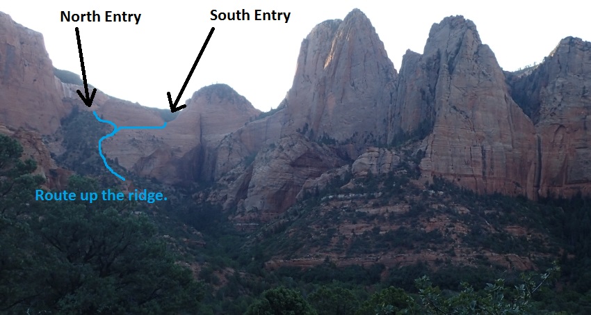 As you hike in on the trail look east to see this view. You
will hike up the drainage then get up to the ridge with the blue route
line on it and work your way up to the respective entry. Note that
this route description only covers the north entry thus far.
As you hike in on the trail look east to see this view. You
will hike up the drainage then get up to the ridge with the blue route
line on it and work your way up to the respective entry. Note that
this route description only covers the north entry thus far.
About 1 mile from the trailhead, the trail drops down into and
crosses a wash (jIceboxCyn). To go to Icebox Canyon turn left (east)
to leave the trail and follow down this drainage a little over 200
feet to where it Tees into another drainage (wIceboxRP-01).
About 210 feet farther is another drainage (wIceboxRP-1). Turn left
to travel north up this drainage. Follow up this drainage as
it goes from north and slowly curves to go northeast.
About 0.67 miles farther is where the drainage begins to travel
mostly east (wIceboxRP-02). Continue east upstream staying in
the main wash avoiding many side minor drainages on both sides.
Sections of the drainage are very overgrown with vegetation and are
bush whacky. You may find various uses trails on either side
that assist in avoiding some of the thick vegetation.
About 0.5 miles farther is a huge boulder broken off of the side
wall of the canyon (wIceboxRP-03). When we were there Aug. 2016 it
looked fairly fresh but not sure. Continue east up the
drainage.
About 300 feet farther is a fork in the wash (wIceboxRP-04) where
you can see a large vertical slickrock wall a short distance up the
left fork. Walk a few feet up the left fork toward the vertical
slickrock wall then note a dirt sloped going up to the right. Walk
up the dirt slope following formed use trails going up to the
following along the base of the slickrock wall.
About 500 feet along the use trails will be a spot (wIceboxRP-05)
where you can scramble up about 10 feet to get to dirt slopes above
going northeast. Climb / scramble up onto the sloped dirt
above then make your way northeast up the thickly vegetated slope.
Once up on the vegetated slope route find your way northeast up onto
the follow up a wide steep vegetated ridge. About 0.25 miles
up the steep ridge you will have good view of two saddles / passes
for entry into Icebox Canyon. The gentle trough shaped saddle
to the right is the south entry and the saddle to the left is the
north entry.
When you get about 475 feet from the top of the ridge
(wIceboxRP-06), you can continue up the crest of the ridge or take
an easier route over toward open slickrock aiming over toward the
south entry.
When you get to an the open slickrock area (wIceboxRP-07) To go to
the north pass entry make your way up a dirt and rock slope about
350 feet to the pass on the left. To go to the south pass entry
contour right to head south toward the smooth trough like pass.
When you get up to the North Pass Entry (yIceBoxTpNorth) enjoy the
views. The slick rock pass for the North Pass Entry to Ice Box Canyon is a big
contrast from the steep sandy vegetation filled ridge climbed to get
here. The contrast makes this entry something worth
seeing. And the views back the way you came are awesome too.
The Canyon / Technical Section:
At the top of
the North Pass Entry (yIceBoxTpNorth)
is a wide trough like slope that descends to the east. There is a
single bolted chain anchor on the LDC side but the trough is not
steep enough to need it unless there were ice and snow. Walk down
the slope.
About 320 feet down from the saddle is a single bolted hanger
(dICeBox-N-Rb) where the slope is gentle and you can walk past this
bolt station. There is a very old single blotted bent piece of metal
anchor about half way between here and the head of the entry.
A short distance down the slope is another optional rap station with
a single bolted hanger (dICeBox-N-Rc). The slope here begins to get
significantly steeper and you can walk it still. However some
parties may decide to set a rappel here. Travel down the slope from
here will likely be best done as a crab walk in a few places.
A short distance later is a flat ledge with an two bolted hangers
which I will call rap 1. Remember depending on conditions
(snow or ice) or comfort level of the party this may not be the
first rappel as different decisions will be made.
Rap 1 (dIceBox-N-R1) is anchored double bolted hangers on a small
ledge where the slope becomes more steep. The rap from here is more
of a hand line to protect a steep slope walk / traverse. From here
look down and way over to the right to find a medium sized pine tree
on a ledge. You will use about 90 feet of rope to get over to the
pine tree for the next rappel. This can be an awkward rappel as you
are traversing a lot and a fall will result in a pendulum tumble.
Rap 2 (dIceBox-N-R2) anchored from a pine tree on a ledge and drops
about 120 feet down to a ledge large enough for 2 to 3 people where
the next rappel is. The rap starts sloped then goes vertical about
half way down.
Rap 3 (dIceBox-N-R3) anchored from 3 bolted hangers on a ledge large
enough for 2 to 3 people and drops about 150 feet to the canyon
floor. At the bottom of rap 3 you are on the canyon floor.
Follow south down the drainage.
About 0.32 miles down canyon is a side canyon (wIceboxRP-08) joining
in from RDC (west). The side canyon is a fun place to upclimb
if you enjoy stemming / galumphing. On our visit Aug. 2016 we
upclimbed 300 to 400 feet up the canyon to where we could see a
couple of upclimbs we did not want to take the time to go up. This
side canyon is worth some looking around if you have time.
About 180 feet down canyon is another side canyon (wIceboxRP-09)
joining in from the LDC (east) side. To get into this side
canyon you would need to climb up a 20 foot vertical wall.
Almost 200 feet down canyon is rap 4.
Rap 4
(dIceBoxR4) is anchored RDC from 2 bolted hangers and involves
traversing a ledge if you want to try to avoid a pool and uses about
50 feet of rope to traverse the RDC ledge and avoid the pool. If
one were to slip or decide to just rap straight down off the
anchors, the rap would drop down into a pool of water in a slot.
Shortly after rap 4
is a very narrow section of the canyon where you will downclimb to a
pool and have a short swim or avoid swimming by walking a ledge on
the RDC side about a foot under the water. About 0.2 miles
farther is rap 5.
Rap 5 (dIceBoxR5) is anchored from a very old single bolt with no
hanger drops about 10 feet into a narrow slot filled with water
where you will likely need to swim about 100 feet. With a lot
of effort you can stem the walls and avoid the water getting wet
only up to your knees but this is a challenge. This rap can be
downclimbed by taller people.
About 1000 feet down canyon of rap 5 is a huge rock fall
area (wIceboxRP-10) to climb over.
Just after the rock fall area is a side canyon (wIceboxRP-11) that
joins in from the LDC (east) side. You can access the canyon
by going up a sloped ramp where you can then bridge / galumph a
short distance up canyon before reaching a large boulder that would
be difficult to safely upclimb.
About 300 feet down canyon is a spring feed pool to bypass on the
RDC side.
Another 500 feet down canyon is the start of a deep slot
(wIceboxRP-12) which is bypassed on very large wide ledge system on
the RDC side. The slot is bypassed since it is full of log
debris and would be difficult to get through. There is also a
large alcove up on the RDC side here to go look at. Walk the
ledge about 400 feet to the next rap.
Rap 6 (dIceBoxR6) is anchored from a single bolted hanger on the RDC
wall and drops about 30 feet down a vertical wall to a large dirt
and rock ledge. Walk in the down canyon direction and route find
your way down to the canyon floor working through vegetated dirt
slopes.
Shortly after getting down to the canyon floor is a huge boulder
debris field which can be a little awkward scrambling through.
Just after the boulder debris is an area well worth taking the time
to look around. There are two trough falls that are very
beautiful.
The top of the first Trough Fall (wIceboxRP-13) is worth the view.
Bypass this first fall and walk the LDC (east) side ridge down into
the bottom of the first trough and to the top of the second trough.
When you get to the bottom of the ridge you will be at the top of
the second trough fall and at the next rap.
Rap 7 (dIceBoxR7) anchored from a tree and drops about 150 feet down
a mostly vertical wall. Before dropping down this rap take a moment
to walk up into the first trough for a scenic treat. The
bottom of the rap is sloped so you could use less rope and walk down
the slope a bit.
From the bottom of rap 7 walk down the trough then scramble your way
down into the main canyon again.
About 400 feet farther down canyon is a drop of a bout 8 feet
(wIceboxRP-14) along the RDC wall. A very aggressive partner
assist can be used to get everyone to the bottom or optionally you
can rig a rappel from a small tree a little ways back.
The rest of the canyon is easy travel to where the Kolob Arch Trail
starts marking the end of the technical canyon (yIceBoxBt). A
short hike on the trail to the right (west) will get you to where you can
view the Kolob Arch.
The Exit:
To exit follow the Kolob Arch trail south about 0.5 miles to the
junction with the La Verkin Creek Trail (jKolobArchTrl ).
From the junction to the La Verkin Creek trail (jKolobArchTrl ) turn
right (south west) and follow the La Verkin Creek trail south west.
From here the trail roughly follows La Verkin Creek.
About 1.8 miles from the junction the trail gets very close to La Verkin Creek
providing a scenic spot to take a break and easily enjoy the water
(sLaVrknCk1).
About 1.1
miles farther is Camp Site 3 (lLaVrknCmp3) where the trail turns right
to head north following along Timber Creek.
About 3.4 miles past camp site 3 is
the La Verkin Creek trailhead / Lee Pass (tLeePass) where your
journey comes to an end back where you started.
Downloadable GPX files
available at
BG-Gear Store
(easier than manual entry and a great way to support
Bluugnome).
Waypoint naming convention and map symbol information can be found on the Glossary page.
Elevations are approximate.
BEFORE
manually entering coordinates set your system to WGS84 datum and Lat/Lon hddd.ddddd° coordinate format.
Inconsistent datum's and coordinate formats will result in location errors.
Click to show / expand the list of waypoints below........
| Icebox North Entry (1) - Approach |
- tLeePass
Lat/Lon (WGS84): N 37.45215
W -113.19120
Elev: 6,070 Feet
Lee Pass TH. Western end of trail the La Verkin Creek trail.
- jIceboxCyn
Lat/Lon (WGS84): N 37.43911
W -113.19128
Elev: NaN Feet
Trail drops down into and crosses a wash here. To go to Icebox Canyon turn left (east) to leave the trail and follow down this drainage a little over 200 feet to where it Tees into another drainage.
- wIceboxRP-01
Lat/Lon (WGS84): N 37.43864
W -113.19103
Elev: 5,562 Feet
The wash from the trail intersects with another drainage here. Turn left to travel north up this drainage. Follow up this drainage as it goes from north and slowly curves to go northeast.
- wIceboxRP-02
Lat/Lon (WGS84): N 37.44444
W -113.18260
Elev: NaN Feet
Somewhat arbitrary point as there is no landmark here. This is about where the drainage begins to head mostly east. Travel east upstream staying in the main wash avoiding many side minor drainages on both sides.
Sections of the drainage are very overgrown with vegetation and are bush whacky. You may find various uses trails on either side that assist in avoiding some of the thick vegetation.
- wIceboxRP-03
Lat/Lon (WGS84): N 37.44516
W -113.17385
Elev: 5,795 Feet
Huge boulder broken off of the side wall of the canyon. When we were there Aug. 2016 it looked fairly fresh but not sure. Continue east up the drainage.
- wIceboxRP-04
Lat/Lon (WGS84): N 37.44540
W -113.17280
Elev: NaN Feet
A fork in the wash where you can see a large vertical slickrock wall a short distance up the left fork. Walk a few feet up the left fork toward the vertical slickrock wall then note a dirt sloped going up to the right. Walk up the dirt slope following formed use trails going up to the following along the base of the slickrock wall. About 500 feet along the use trails will be a spot to climb / scramble up about 10 feet.
- wIceboxRP-05
Lat/Lon (WGS84): N 37.44448
W -113.17153
Elev: NaN Feet
A spot where you can scramble up about 10 feet to get to dirt slopes above going northeast. Climb / scramble up onto the sloped dirt above then make your way northeast up the thickly vegetated slope.
Once up on the vegetated slope route find your way northeast up onto the follow up a wide steep vegetated ridge.
- wIceboxRP-06
Lat/Lon (WGS84): N 37.44710
W -113.16797
Elev: 6,620 Feet
As you get closer to the top of the ridge you can see both entry passes to Icebox canyon. The gentle trough shaped saddle to the right is the south entry and the saddle to the left is the north entry. When you get about 475 feet from the top of the ridge, you can continue up the crest of the ridge or take an easier route over toward open slickrock aiming over toward the south entry.
- wIceboxRP-07
Lat/Lon (WGS84): N 37.44637
W -113.16673
Elev: 6,760 Feet
Open slickrock area just below the entry points for Icebox Canyon. To go to the north pass entry make your way up a dirt and rock slope about 350 feet to the pass on the left. To go to the south pass entry contour right to head south toward the smooth trough like pass.
- yIceBoxTpNorth
Lat/Lon (WGS84): N 37.44708
W -113.16568
Elev: 6,960 Feet
Top of North Pass Entry for Icebox Canyon. A wide trough like slope that descends to the east. Tehre is a single bolted chain anchor on the LDC side but the trough is not steep enough to need it unless there were ice and snow. Walk down the slope.
|
| Icebox North Entry (2) - The Canyon, |
- yIceBoxTpNorth
Lat/Lon (WGS84): N 37.44708
W -113.16568
Elev: 6,960 Feet
Top of North Pass Entry for Icebox Canyon. A wide trough like slope that descends to the east. Tehre is a single bolted chain anchor on the LDC side but the trough is not steep enough to need it unless there were ice and snow. Walk down the slope.
- dICeBox-N-Rb
Lat/Lon (WGS84): N 37.44708
W -113.16459
Elev: 0 Feet
Optional rap station about 320 feet down from the head of the North Pass Entry. This is a single bolted hanger where the slope is gentle and you can walk past this bolt station. There is a very old single bolted bent piece of metal anchor about half way between here and the head of the entry.
- dICeBox-N-Rc
Lat/Lon (WGS84): N 37.44704
W -113.16432
Elev: 6,720 Feet
Approximate location of another optional rap station with a single bolted hanger. The slope here begins to get significantly steeper and you can walk it still. However some parties may decide to set a rappel here. Travel down the slope from here will likely be best done as a crab walk in a few places.
- dIceBox-N-R1
Lat/Lon (WGS84): N 37.44705
W -113.16407
Elev: NaN Feet
Rap 1 - Icebox Canyon North Entry. Anchored from double bolted hangers on a small ledge where the slope becomes more steep. The rap from here is more of a hand line to protect a steep slope walk / traverse. From here look down and way over to the right to find a medium sized pine tree on a ledge. You will use about 90 feet of rope to get over to the pine tree for the next rappel. This can be an awkward rappel as you are traversing a lot and a fall will result in a pendulum tumble.
- dIceBox-N-R2
Lat/Lon (WGS84): N 37.44685
W -113.16385
Elev: NaN Feet
Rap 2 - Icebox Canyon North Entry. Anchored from a pine tree on a ledge and drops about 120 feet down to a ledge large enough for 2 to 3 people where the next rappel is. The rap starts sloped then goes vertical about half way down.
- dIceBox-N-R3
Lat/Lon (WGS84): N 37.44683
W -113.16361
Elev: 0 Feet
Rap 3 - Icebox Canyon North Entry. Anchored from 3 bolted hangers on a ledge large enough for 2 to 3 people and drops about 150 feet to the canyon floor.
- wIceboxRP-08
Lat/Lon (WGS84): N 37.44280
W -113.16064
Elev: NaN Feet
A side canyon comes in from the RDC (west) side and is a fun place to upclimb if you enjoy stemming / galumphing. On our visit Aug. 2016 we upclimbed 300 to 400 feet up the canyon to where we could see a couple of upclimbs we did not want to take the time to go up. This side canyon is worth some looking around if you have time.
- wIceboxRP-09
Lat/Lon (WGS84): N 37.44239
W -113.16031
Elev: NaN Feet
Another side canyon joins in from LDC (east). To get into this side canyon you would need to climb up a 20 foot vertical wall.
- dIceBoxR4
Lat/Lon (WGS84): N 37.44203
W -113.15998
Elev: NaN Feet
Rap 4 - Icebox Canyon. Anchored RDC from 2 bolted hangers and involves traversing a ledge if you want to try to avoid a pool and uses about 50 feet of rope to traverse the RDC ledge and avoid the pool.
- dIceBoxR5
Lat/Lon (WGS84): N 37.43965
W -113.15854
Elev: NaN Feet
Rap 5 - Icebox Canyon. Anchored from a very old single bolt with no hanger drops about 10 feet into a narrow slot filled with water where you will likely need to swim about 100 feet. With a lot of effort you can stem the walls and avoid the water getting wet only up to your knees but this is a challenge. This rap can be downclimbed by taller people.
- wIceboxRP-10
Lat/Lon (WGS84): N 37.43642
W -113.15654
Elev: NaN Feet
Rock fall area to climb over.
- wIceboxRP-11
Lat/Lon (WGS84): N 37.43548
W -113.15581
Elev: 6,157 Feet
Side canyon that joins in from the LDC (east) side. You can access the canyon by going up a sloped ramp where you can then bridge / galumph a short distance up canyon before reaching a large boulder that would be difficult to safely upclimb.
About 300 feet down canyon is a spring feed pool to bypass on the RDC side.
- wIceboxRP-12
Lat/Lon (WGS84): N 37.43327
W -113.15452
Elev: NaN Feet
Start of a deep slot (wIceboxRP-12) which is bypassed on very large wide ledge system on the RDC side. The slot is bypassed since it is full of log debris and would be difficult to get through. There is also a large alcove up on the RDC side here to go look at. Walk the ledge about 400 feet to the next rap.
- dIceBoxR6
Lat/Lon (WGS84): N 37.43220
W -113.15392
Elev: 6,000 Feet
Rap 6 - Icebox Canyon. Anchored from a single bolted hanger on the RDC wall and drops about 30 feet down a vertical wall to a large dirt and rock ledge. Walk in the down canyon direction and route find your way down to the canyon floor working through vegetated dirt slopes.
Shortly after getting down to the canyon floor is a huge boulder debris field which can be a little awkward scrambling through. Just after the boulder debris is an area well worth taking the time to look around. There are two trough falls that are very beautiful.
- wIceboxRP-13
Lat/Lon (WGS84): N 37.43075
W -113.15301
Elev: NaN Feet
Top of the first of two trough falls. These are huge trough shaped waterways with spring fed trickliing waterfalls. This area is well worth the time to look around and spend some time in. Bypass this first fall and walk the LDC (east) side ridge down into the bottom of the first trough and to the top of the second trough.
- dIceBoxR7
Lat/Lon (WGS84): N 37.43031
W -113.15236
Elev: NaN Feet
Rap 7 - Icebox Canyon at the top of the second trough fall. Anchored from a tree and drops about 150 feet down a mostly vertical wall. Before dropping down this rap take a moment to walk up into the first trough for a scenic treat. The bottom of the rap is sloped so you could use less rope and walk down the slope a bit.
From the bottom of rap 7 walk down the trough then scramble your way down into the main canyon again.
- wIceboxRP-14
Lat/Lon (WGS84): N 37.42925
W -113.15119
Elev: NaN Feet
Drop of about 8 feet along the RDC wall. A very aggressive partner assist can be used to get everyone to the bottom or optionally you can rig a rappel from a small tree a little ways back.
- yIceBoxBt
Lat/Lon (WGS84): N 37.42275
W -113.15212
Elev: 5,350 Feet
Bottom of the Ice Box Canyon where it meets the Kolob Arch trail. A short walk up the trail to the right (west) will get you to a point where you can view Kolob Arch.
|
| Icebox North Entry (3) - Exit |
- yIceBoxBt
Lat/Lon (WGS84): N 37.42275
W -113.15212
Elev: 5,350 Feet
Bottom of the Ice Box Canyon where it meets the Kolob Arch trail. A short walk up the trail to the right (west) will get you to a point where you can view Kolob Arch.
- jKolobArchTrl
Lat/Lon (WGS84): N 37.41582
W -113.15119
Elev: 5,250 Feet
Junction where the Kolob Arch trail meets the La Verkin Creek trail. To go back to Lee Pass after getting out of Icebox Canyon, turn right and follow the La Verkin Creek Trail southwest.
- lLaVrknCmp5
Lat/Lon (WGS84): N 37.41024
W -113.16998
Elev: 5,112 Feet
Cunction to camp site 5
- lLaVrknCmp4
Lat/Lon (WGS84): N 37.40706
W -113.17576
Elev: 5,100 Feet
Junction to Camp Site 4
- sLaVrknCk1
Lat/Lon (WGS84): N 37.40576
W -113.17896
Elev: 5,050 Feet
Trail gets close to La Verkin Creek. Nice scenic place to take a break by the water. To go back to Lee Pass TH, continue southwest.
- lLaVrknCmp3
Lat/Lon (WGS84): N 37.40738
W -113.19666
Elev: 5,435 Feet
Camp site 3 where the trail turns right to head north following along Timber Creek back to the Lee Pass TH.
- lLaVrknCmp2
Lat/Lon (WGS84): N 37.41651
W -113.19188
Elev: 5,445 Feet
Camp site 2 on the Laverkin Creek Trail.
- lLaVrknCmp1
Lat/Lon (WGS84): N 37.42246
W -113.19630
Elev: 5,440 Feet
Camp site 1 on the La Verkin Creek Trail.
- jIceboxCyn
Lat/Lon (WGS84): N 37.43911
W -113.19128
Elev: NaN Feet
Trail drops down into and crosses a wash here. To go to Icebox Canyon turn left (east) to leave the trail and follow down this drainage a little over 200 feet to where it Tees into another drainage.
- tLeePass
Lat/Lon (WGS84): N 37.45215
W -113.19120
Elev: 6,070 Feet
Lee Pass TH. Western end of trail the La Verkin Creek trail.
|