Canyoneering Route Description
Dothraki Canyon - 3A II (III)
Hildale / Short Creek, Utah
Near
Zion National Park
09-15-18, 4 people, 1 Day (Travel time in route 8.7 hours)

Time Required - 7 to 9 hours
Distance via Squirrel Canyon TH - 4 miles Total,
0.8 miles Technical
Distance via Maxwell Park
- 3.5 miles Total, 0.8 miles Technical
Rappels - 14 Rappels, Longest Rappel 180 feet.
Some raps can be downclimbed potentially reducing rap count
Elevation Range - 5170 - 7090 Feet
Shuttle Required - No from Squirrel Canyon TH. 1.6 Miles
if from Maxwell Park Vehicle - Passenger
Permit Required - No
Rappelling and anchor gear, Ropes and or pull cords for rappels up
to 180 feet and 80 feet of 1 inch webbing for sling placement.
Dothraki Canyon is a great day out with great views on
the approach, scenic narrows, fun downclimbs and multiple rappels. Dothraki
Canyon may be a good alternative canyon if you find the near by Water Canyon
over crowded. Dothraki Canyon is not recommended during the hottest part of
summer as there is little water and may be quite warm. Dothraki is very much
worth the visit.
The skinniest part of the canyon is between raps 3 and
4 where some light stemming is required to get over some tight spots and
avoid getting your feet wet in a few spots. Even large barrel chested people
will be able to fit through the smallest part with moderate effort. There
have already been a couple of guys over 230 pounds fit through fine.
The last 7 of the 14 rappels are packed into the last
450 feet of canyon and stack up pretty close to one another. A few of the
raps can be downclimbed. Depending on your downclimbing skills you may have
fewer than 15 rappels.
There are two ways to approach Dothraki Canyon, from
the Squirrel Canyon TH or from Maxwell Park. The approach from the Squirrel
Canyon Trailhead requires no shuttle, is a little longer, and has sections
of steep sand and loose rock to go up. The approach from Maxwell Park
requires a shuttle of about 1.6 miles, is a little shorter, and has a few
short sections to climb that are guesstimated to be rated as 5.7 to 5.8.
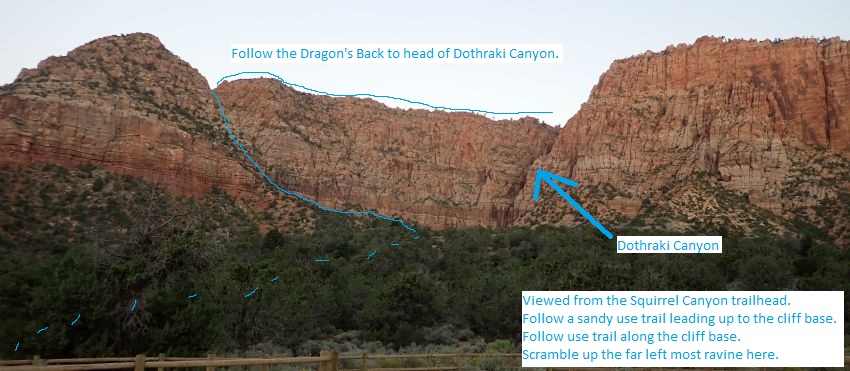
Approach from Squirrel Canyon trailhead:
The route description here is for the approach from Squirrel Canyon TH. This
approach has about 600 feet of elevation gain up semi steep sandy road and
use trails to the cliff band then follows up a ravine through the cliff band
gaining an additional 450 feet with a few sections of very steep sand and
loose rock. Take your time while navigating this section. Once at the top of
the ravine you will be on a ridge known locally as the Dragon's Back which
you then scramble and walk all the way up to the head of the canyon with
great views over the area. The route up the ravine to the Dragon's Back has
a couple of portions that are difficult to describe in words. Be ready to do
a little route finding in a couple short sections, but overall the route is
pretty intuitive.
Approach from Maxwell Park:
I have
not done the Maxwell Park approach yet so I can not offer first hand
knowledge about the climbing sections. The route was pointed out to me from
Maxwell Park and I was told there are 2 or 3 sections of about 15 feet each
that require climbing.
Both approach routes join on the ridge (known as the Dragon's Back) then
follow the ridge to the head of the canyon. The Dragon's Back has no trails
and involves sections of steep but easy scrambling and offer awesome views
over the Hildale / Short Creek area. Looking up along the Dragon's Back is
pretty special as well.
The head of the left fork of Dothraki Canyon
is passed while on approach to the right fork. I have not done that fork but
was told it has 3 rappels and is not as good as the right fork described
here.
Thanks to Worth Bistline and Charlie Barlow for sharing this
fun route. Taylor Bistline had been looking at this slot for years and got
Charlie and Worth interested in it. The first couple times Worth and Charlie
decided to go check the place out Taylor was busy and the trip postponed.
Taylor was unable to join Worth and Charlie on the first decent on 07-14-18.
In the interest of making this a quick fun day out for those who what to go
through Dothraki most of the drops are bolted as natural anchor options at
some of these drops can be tricky.
Worth had this to say for the
reason behind the name Dothraki Canyon:
"... many of the locals call the
approach, “dragon back ridge.” The creek in the canyon I’ve heard called
“Horse Creek,” but I haven’t found records of either. We got creative and
combined dragons and horses. Lol. Or, Game of Thrones people, the Dothraki,
who are expert horseman and resemble the native Americans in many respects.
Hence, Dothraki Canyon."
To get to the Trailhead
From the junction of highways 9 and 59 in Hurricane Utah, drive
about 21.8 miles to the turn of for Utah Avenue in the city of
Hildale Utah (extUtahAve).
Hildale is on the border of Utah and Arizona. On the Utah side
of the border the city is Hildale and the highway number is 59.
On the Arizona side of the border the city is Colorado City and
the highway number is 389.
Turn left (east) onto Utah Avenue. Follow Utah Avenue 2.1 miles
to where the street sweeps left (north) and becomes Canyon
Street (extCanyonSt).
Continue north on Canyon Street 0.8 miles to Water Canyon Road (ExtWaterCynRd).
Turn right on Water Canyon Road which is dirt. Follow Water
Canyon Road 0.8 miles to a fork in the road (wWaterCynDP-01) and
stay right at the fork. Another 0.2 miles will be another fork
(wWaterCynDP-02) turn right and park at the Squirrel Canyon TH.
If doing the Maxwell Canyon approach leave the exit vehicle here
at Squirrel Canyon trailhead then......
Drive 1.6 miles south
back down the Water Canyon road back to Canyon Street.
Turn right (west) onto Canyon Street and follow it west about
0.5 miles to Maxwell Canyon.
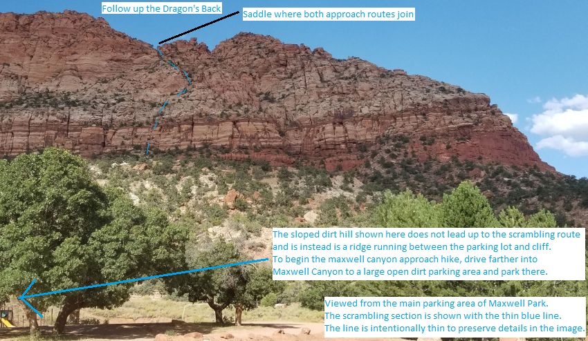
The scramble route on the cliffs above is best viewed from the
main parking area in Maxwell Canyon but the approach hike begins
at the far end of the park in a large open dirt lot.
To leave the Exit Vehicle / Escape Pod
Park the exit vehicle at the Squirrel Canyon trailhead
regardless of the approach used.
GPS coordinate information listed at the bottom. For information about waypoint naming and map symbols, refer to the
Glossary page.

Click the links for maps of the route.
Map of the drive into the route.
Map of the entire route.
Map of first part of approach from Squirrel Canyon TH.
Map of the technical section.
The Approach -
From Maxwell Park:
I have
not done the Maxwell Park approach yet so I can not offer first hand
knowledge about the climbing sections. The route was pointed out to me from
Maxwell Park and I was told there are 2 or 3 sections of about 15 feet each
that require climbing.
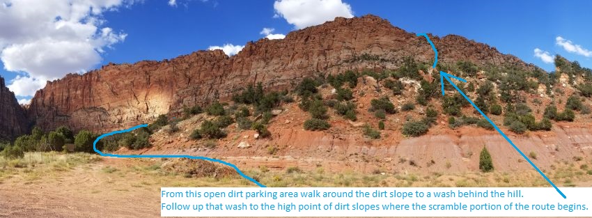
The scrambling / climb portion of the Maxwell approach
is best seen from the parking area in the main part of the park. The line
drawn shows the route. However the tall dirt hills up from the main parking
lot do not lead up to the cliffs but are a false peak between the parking
lot and cliffs. The best way to approach from Maxwell Park is to drive
farther into the park to a large open dirt parking lot. From there hike
north up around a dirt ridge and into a wash on the other side. That wash is
then followed up which leads up to the high point of dirt slopes at the
cliff base, which is where the scrambling begins. I have not done this route
but have been given the details provided by those who have done it.
 View from main
parking area in Maxwell Canyon. Scramble route best viewed here but
route begins from farther into the park at large open dirt lot.
View from main
parking area in Maxwell Canyon. Scramble route best viewed here but
route begins from farther into the park at large open dirt lot.
 View from large
dirt lot where the approach begins.
View from large
dirt lot where the approach begins.
I have not done this
route so there are no
other details to offer
at this time.
Approach - From
Squirrel Canyon
trailhead:
From the Squirrel
Canyon trailhead (pkSquirrelTH)
walk south down the road
about 200 feet to where
a sandy use trail / ATV
trail leaves the road
(Dothraki01) and travels
west up a sandy hill.
About 400 feet up the
slope the trail joins a
wider sandy road.
Continue west up the
slope following the
sandy road up the hill
for about 0.3 miles to a
gentle left bend in the
road.
 View from main
parking area in Maxwell Canyon. Scramble route best viewed here but
route begins from farther into the park at large open dirt lot.
View from main
parking area in Maxwell Canyon. Scramble route best viewed here but
route begins from farther into the park at large open dirt lot.
From the gently swept
left turn in the steep
sandy road and a brief
level spot (Dothraki02),
continue west up the
steep sandy road.
About 500 feet farther
is a wide turn out in
the road (Dothraki03).
Continue up the sandy
road from here as it
slowly gets more narrow.
About 1000 feet farther
the sandy road becomes
too narrow for ATVs and
is more of a use trail
(Dothraki04). Continue
west up the sandy ridge
to the base of the
cliffs.
Note:
On the exit
this is where a small
use trail meets up with
this main trail on the
ridge. To exit turn left
and follow east down the
sand ridge back to the
Squirrel Canyon TH.
About 300 feet farther
the sandy ridge meets
the cliff band
(Dothraki05). Turn left
and go southeast along
intermittent use trail
and light scrambling
roughly following the
base of the cliff.
About 300 feet farther
along the cliff band is
the route crosses over a
minor drainage
(Dothraki06). Continue
following use trail and
light scrambling
southeast along the
cliff base for about 200
feet to the far side of
a major ravine running
southwest up the cliffs.
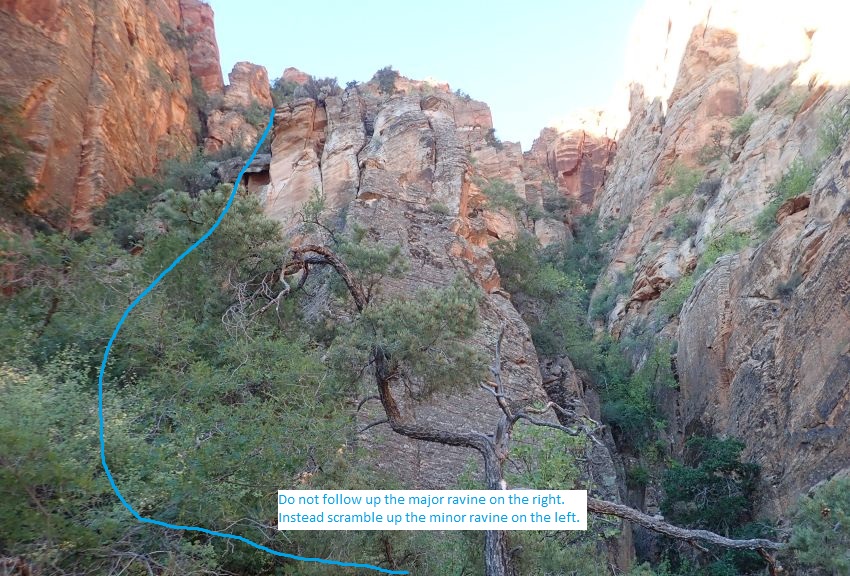
About 200 feet farther
you will be on the far
south side of a ravine
running southwest up the
cliffs (Dothraki07). As
you look southwest up
the ravine notice that
there is a major / large
ravine on the right and
a smaller ravine on the
left running parallel to
the large ravine. Start
up the far left
(southeast) side of the
minor ravine roughly
following the left wall
for about 250 feet to
the base of what looks
like a large monolith
rock in the ravine.
Starting up into this
ravine is steep but well
featured and easy to
travel scrambling.
Note: As you go up the
ravine to the base of
the monolith stay left
following up along the
base of the left wall
until you are cliffed
out at the base of the
monolith. You want to go
all the way up to the
base of the monolith and
not try to cut out
early. There are a few
spots where you can go
to the right but they
will lead to difficult
terrain.
Note: A couple
sections of this portion
of the ravine are very
steep and loose sand and
you will need to use
hands and feet to get up
these.
 View from main
parking area in Maxwell Canyon. Scramble route best viewed here but
route begins from farther into the park at large open dirt lot.
View from main
parking area in Maxwell Canyon. Scramble route best viewed here but
route begins from farther into the park at large open dirt lot.
Once at the base of what
looks like a monolith
blocking progress up the
ravine (Dothraki08)
scramble right
(northwest) following
chunky rock and dirt up
along the base of a
cliff for about 60 feet
to get over to where you
can go around a corner
and begin to scramble up
to the left (southwest)
going up a rocky ridge.
Note:
This 60 foot section has
some very loose rock and
a mix of live and dead
vegetation. Pay close
attention here as some
of the rock may break
away and not all the
vegetation is strong
enough to support you.
Once out near the crest
of a ridge (Dothraki09),
turn left (southwest)
and begin scrambling up
the ridge following an
easy to walk and
scramble route to the
right (northish) of the
ridge and not directly
on the crest. After
about 50 feet you can
easily scramble up
toward the crest of the
ridge.
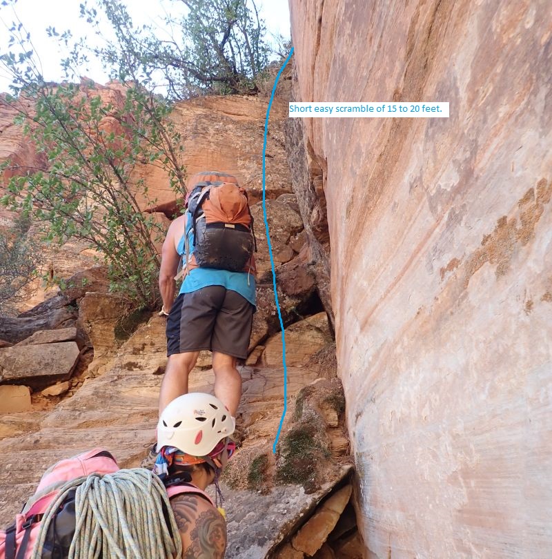
As you get close to the
crest of the ridge
(Dothraki10) you will
see an easy scramble up
of about 15 feet gentle
angle and well featured.
You can go farther south
and go up but it leads
to more difficult
scrambling.
 View from main
parking area in Maxwell Canyon. Scramble route best viewed here but
route begins from farther into the park at large open dirt lot.
View from main
parking area in Maxwell Canyon. Scramble route best viewed here but
route begins from farther into the park at large open dirt lot.
After
getting up this scramble
follow up steep but much
easier terrain with one
more minor scramble up
for about 300 feet to
the crest of the
Dragon's Back.
Once on the crest of the
Dragon's Back
(Dothraki11), walk and
scramble about 140 feet
over and down to a
saddle.
The large saddle
(Dothraki12) continue
northwest up the ridge
by scrambling up the
slick rock directly up
from the crest of the
saddle. The scramble up
looks intimidating and
difficult but is
straight forward and
pretty easy.
Note:
The approach up from
Maxwell Canyon gets to
the ridge here where
both approach routes
join.
About 500 feet along the
ridge is a minor high
point (Dothraki13) along
the Dragon's Back. From
here you have a great
view looking up along
the Dragon's Back you
will be traveling. It
looks like it will be a
lot of scrambling work
but travels a lot easier
than it looks. Continue
northwest along the
crest of the ridge with
a mix of scrambling and
walking.
About 0.5 miles along
the Dragon's Back is
short semi level section
(Dothraki14). Kind of an
arbitrary point as you
will just be following
the ridge.
About 1000 feet farther
along the ridge is a
saddle slightly left of
the crest of the ridge
(Dothraki15) where
travel is easier with
less scrambling. Travel
from here slowly gets
wider and is more
walking and no
scrambling.
About 1200 feet farther
is a semi level open
area (jDothrLF) where
you can walk southeast
down into the top of the
left fork of Dothraki
Canyon.
Note:
I have not done the
left fork of
Dothraki but have been
told it is not as good
as the main / right
fork. There are 3
raps in the left fork
where the last one drops
down from a ledge into
the main canyon.
To continue to the
main canyon / right fork
continue northwest up
the gently sloped dirt
and rock about 300 feet
then veer right and walk
northeast another 300
feet over to the head of
Dothraki Canyon.
The Canyoneering / Technical Section:
From the head of
Dothraki Canyon (yDothrakiTp)
walk down canyon walking
along sloped slickrock
on the LDC (northeast)
side for about 250 feet
to a tree for rap 1.
Rap 1 (dDothrakiR01)
anchored from a tree and
drops about 95 feet down
the LDC wall to the
canyon floor. Top of the
rap is sloped then gives
way to a vertical wall
with some free hang on
the way down.
After rap 1 are several
downclimbs as the canyon
drops rapidly between
narrow walls sometimes
about shoulder width
apart. One of these
downclimbs can be tricky
over the sloped, sand
covered slick rock where
partner assist or hand
line may be a good idea.
Rap 2 (dDothrakiR02) is
on a ledge on the LDC
side anchored from 2
bolted hangers about
head high and drops
about 150 feet down the
vertical LDC wall.
Optionally boulders at
your feet can be used as
the anchor. As you lean
out on rope at the top
of the rap you have
great views down the
long narrow canyon.
After rap 2 walk down
canyon about 200 feet
between shoulder width
walls to rap 3.
Rap 3 (dDothrakiR03) is
anchored from 2 bolted
hangers on the RDC wall
and drops about 30 feet
through a narrow crack.
You will need to lean
out over the narrow
crack to reach the
anchor. Alternately a
knot chalk anchor can be
used and the rappel done
in the down canyon
direction on the LDC
side.
After rap 3 is a
downclimb of about 8
feet followed by the
skinny section of the
canyon. The skinny
section requires some
light stemming to get
over a few spots and
avoid getting your feet
wet in a couple spots.
The skinniest spot is
still wide enough for
even the large guys to
fit and is only a few
feet long.
Rap 4 (dDothrakiR04) is
anchored from bolted
hangers on the RDC side
and drops about 55 feet
down through narrow
crack.
Down canyon of rap 4 is
some flat walking
narrows and another
skinny section but not
as skinny as the section
up canyon. There is one
short drop between
narrow walls where you
can stem down canyon
over a choke stone
between narrow walls to
avoid possibly deep
water below. Then the
canyon becomes wider and
offers a long section of
flat easy walking with
trees and tall walls.
About 1000 feet down
canyon of rap 4 is where
the left fork drops into
the main / right fork
from a ledge about 60
feet up on the RDC side
(jDothrakiConf) and is
easily overlooked while
traveling down the main
canyon. If you keep an
eye up on the ledge you
may be able to see
webbing tied to a tree
that was used to rap
down from the left fork.
About 500 feet farther
is a short narrow
section (Dothraki16)
about 150 feet long just
before rap 5. Just
before reaching rap 5 is
a drop of about 15 feet
which is bypassed going
around on the LDC side
to a more gentle slope.
Rap 5 (dDothrakiR05) is
anchored from 2 bolted
hangers on the LDC side
and drops about 70 feet
down vertical wall. A
safety tether is a good
idea here as the rap
station is exposed.
After rap 5 is more flat
walking with a couple
minor scrambles before
reaching rap 6.
Rap 6 (dDothrakiR06) is
anchored from 2 bolted
hangers where the canyon
makes a short jog to the
left and drops about 20
feet down vertical wall.
At the bottom of the rap
can be water and will
usually avoidable but
may get your feet wet if
there is a lot of water.
Down canyon is a couple
short easy downclimbs in
narrow canyon to the
next rap about 100 feet
down canyon.
Rap 7 (dDothrakiR07)
is anchored LDC from 2
bolted hangers and drops
about 60 feet down to a
narrow section.
Just after rap 7 is a
couple stem style
downclimbs of about 12
foot each that are well
featured but may be a
little wide for some
people who may want a
meat anchor. Rap 8
is about 300 feet down
canyon.
Rap 8 (dDothrakiR08) is
anchored from a tree
head high where the
canyon makes a short
right jog and drops
about 40 feet. Shortly
down canyon is the next
rap.
Rap 9 (dDothrakiR09) is
anchored LDC from bolted
hangers and drops about
35 feet down sloped
rock. Rap 9 could be
downclimbed but would be
a little spicy at the
top. Shortly down canyon
is the next rap.
Rap 10 (dDothrakiR10) is
anchored LDC from bolted
hangers and drops about
12 feet. Rap 10 can be
downclimbed as a wide
stem with slick walls
near the bottom. Shortly
down canyon is the next
rap.
Rap 11 (dDothrakiR11) is
anchored LDC from 2
bolted hangers and drops
about 25 feet. Shortly
down canyon is the next
rap.
Rap 12 (dDothrakiR12) is
anchored LDC from bushes
and drops about 25 feet
and can be downclimbed
but could be spicy about
midway down as you
transition out of a
chute / crack. The
anchor for rap 12 may be
hard to find as it is
from a bush at the top
of some rocks and you
need to look up there
for it. Shortly down
canyon is the next rap.
Rap 13 (dDothrakiR13) is
anchored from a log at
the top and drops about
15 feet. Rap 13 can be
downclimbed as a stem
style downclimb but
slick walls may make it
difficult. Optionally
you can bypass rap 13 by
going up and over on the
LDC side and scrambling
down a sloped ledge. The
log anchor is dependent
on some large rocks that
felt a little loose so
it may disappear one
day. Be prepared to find
another anchor or just
downclimb. Shortly down
canyon is the next rap.
Rap 14 (dDothrakiR14) is
anchored LDC from 2
bolted hangers and drops
about 180 feet over rock
ledges, boulders and
some bushes to fight
over. There is a second
anchor slung from a rock
if you want to break
this rappel into two.
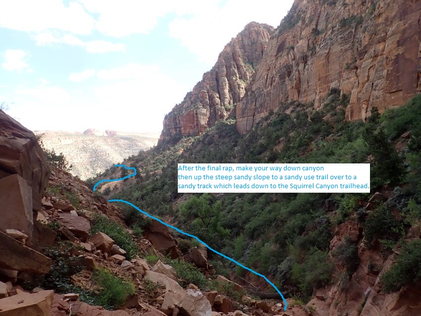
After getting to the
bottom of the last rap
(Dothraki17) look down
canyon and note a use
trail in the sand high
on the bank on the RDC
side. To exit you will
continue down canyon to
where you can claw your
way up steep sand slope
to get to that use trail
then follow that use
trail over to the sand
ridge with a trail /
road running down to the
Squirrel Canyon TH. This
is the same sand ridge
used if you approached
the canyon from the
Squirrel Canyon TH.
A rubble filled slope to
scramble down about 200
feet down canyon of the
final rap is marked as
the end of the technical
canyon (yDothrakiBt).
 View from main
parking area in Maxwell Canyon. Scramble route best viewed here but
route begins from farther into the park at large open dirt lot.
View from main
parking area in Maxwell Canyon. Scramble route best viewed here but
route begins from farther into the park at large open dirt lot.
The Exit:
From the
end of the canyon (yDothrakiBt
) walk down canyon with
a couple short drops for
about 250 feet to where
you can claw your way up
the sand slope on the
RDC side.
Leave the drainage
(Dothraki18) and claw
your way up the steep
sand bank on the RDC
side up to the use trail
above.
Abut 400 feet farther
the use trail crosses
over a minor drainage.
Follow the use trail
southeast about 200 feet
over to the large sand
ridge with a larger use
trail.
Once on the larger use
trail (Dothraki04) turn
left and follow east
down the sand ridge back
to the Squirrel Canyon
TH.
Downloadable GPX files
available at
BG-Gear Store
(easier than manual entry and a great way to support
Bluugnome).
Waypoint naming convention and map symbol information can be found on the Glossary page.
Elevations are approximate.
BEFORE
manually entering coordinates set your system to WGS84 datum and Lat/Lon hddd.ddddd° coordinate format.
Inconsistent datum's and coordinate formats will result in location errors.
Click to show / expand the list of waypoints below........
| Dothraki (1) - Drive in to Trailhead |
- extUtahAve
Lat/Lon (WGS84): N 37.00351
W -113.00152
Elev: NaN Feet
Hwy 59 and Utah Ave.
- extCanyonSt
Lat/Lon (WGS84): N 37.00361
W -112.96330
Elev: NaN Feet
Canyon St and Utah Ave
- ExtWaterCynRd
Lat/Lon (WGS84): N 37.01456
W -112.96230
Elev: NaN Feet
Turn off for Water Canyon road.
- wWaterCynDP-01
Lat/Lon (WGS84): N 37.02268
W -112.95406
Elev: NaN Feet
Fork in the dirt road stay right on the drive in to Water Canyon.
- Dothraki01
Lat/Lon (WGS84): N 37.02575
W -112.95369
Elev: 5,160 Feet
Sandy use trail / ATV trail leaves the road and travels west up a sandy hill. About 400 feet up the slope the trail joins a wider sandy road. Continue west up the slope following the sandy road up the hill for about 0.3 miles to a gentle left bend in the road.
- wWaterCynDP-02
Lat/Lon (WGS84): N 37.02609
W -112.95330
Elev: NaN Feet
Fork in the dirt road stay left on the drive in to Water Canyon or if doing Dothraki Canyon turn right and park at the Squirrel Canyon TH.
- pkSquirrelTH
Lat/Lon (WGS84): N 37.02629
W -112.95283
Elev: 5,170 Feet
|
| Dothraki (2) - Approach from Squirrel to where approach routes join |
- pkSquirrelTH
Lat/Lon (WGS84): N 37.02629
W -112.95283
Elev: 5,170 Feet
- wWaterCynDP-02
Lat/Lon (WGS84): N 37.02609
W -112.95330
Elev: NaN Feet
Fork in the dirt road stay left on the drive in to Water Canyon or if doing Dothraki Canyon turn right and park at the Squirrel Canyon TH.
- Dothraki01
Lat/Lon (WGS84): N 37.02575
W -112.95369
Elev: 5,160 Feet
Sandy use trail / ATV trail leaves the road and travels west up a sandy hill. About 400 feet up the slope the trail joins a wider sandy road. Continue west up the slope following the sandy road up the hill for about 0.3 miles to a gentle left bend in the road.
- Dothraki02
Lat/Lon (WGS84): N 37.02740
W -112.95827
Elev: NaN Feet
Gently sweeped left turn in the steep sandy road and a brief level spot. Continue west up the steep sandy road.
- Dothraki03
Lat/Lon (WGS84): N 37.02730
W -112.96002
Elev: NaN Feet
Wide turn out in the road. Continue up the sandy road from here as it slowly gets more narrow.
- Dothraki04
Lat/Lon (WGS84): N 37.02639
W -112.96335
Elev: NaN Feet
Sandy road becomes too narrow for ATVs and is more of a use trail. Continue west up the sandy ridge to the base of the cliffs. On the exit this is where a small use trail meets up with this main trail on the ridge. To exit turn left and follow east down the sand ridge back to the Squirrel Canyon TH.
- Dothraki05
Lat/Lon (WGS84): N 37.02620
W -112.96440
Elev: 5,780 Feet
Sandy ridge meets the cliff band. Turn left and go southeast along intermittent use trail and light scrambling roughly following the base of the cliff.
- Dothraki06
Lat/Lon (WGS84): N 37.02556
W -112.96370
Elev: NaN Feet
Route crosses over a minor drainage. Continue following use trail and light scrambling southeast along the cliff base for about 200 feet to the far side of a major ravine running southwest up the cliffs.
- Dothraki07
Lat/Lon (WGS84): N 37.02530
W -112.96313
Elev: 5,810 Feet
Far south side of a ravine running southwest up the cliffs. As you look southwest up the ravine notice that there is a major / large ravine on the right and a smaller ravine on the left running parallel to the large ravine. Start up the far left (southeast) side of the minor ravine roughly following the left wall for about 250 feet to the base of what looks like a large monolith rock in the ravine. Starting up into this ravine is steep but well featured and easy to travel scrambling.
Note: As you go up the ravine to the base of the monolith stay left following up along the base of the left wall until you are cliffed out at the base of the monolith. You want to go all the way up to the base of the monolith and not try to cut out early. There are a few spots where you can go to the right but they will lead to difficult terrain.
Note: A couple sections of this portion of the ravine are very steep and loose sand and you will need to use hands and feet to get up these.
- Dothraki08
Lat/Lon (WGS84): N 37.02470
W -112.96345
Elev: NaN Feet
Base of what looks like a monolith blocking progress up the ravine. From here scramble right (northwest) following chunky rock and dirt up along the base of a cliff for about 60 feet to get over to where you can go around a corner and begin to scramble up to the left (southwest) going up a rocky ridge.
Note: This 60 foot section has some very loose rock and a mix of live and dead vegetation. Pay close attention here as some of the rock may break away and not all the vegetation is strong enough to support you.
- Dothraki09
Lat/Lon (WGS84): N 37.02481
W -112.96356
Elev: NaN Feet
Crest of a ridge. Turn left (southwest) and begin scrambling up the ridge following an easy to walk and scramble route to the right (northish) of the ridge and not directly on the crest. After about 50 feet you can easily scramble up toward the crest of the ridge.
- Dothraki10
Lat/Lon (WGS84): N 37.02477
W -112.96373
Elev: NaN Feet
As you get close to the crest of the ridge here you will see an easy scramble up of about 15 feet gentle angle and well featured. You can go farther south and go up but it leads to more difficult scrambling. After getting up this scramble follow up steep but much easier terrain with one more minor scramble up for about 300 feet to the crest of the Dragon's Back.
- Dothraki11
Lat/Lon (WGS84): N 37.02394
W -112.96399
Elev: 6,290 Feet
On the crest of the Dragon's Back. Walk and scramble about 140 feet over and down to a saddle.
- Dothraki12
Lat/Lon (WGS84): N 37.02406
W -112.96445
Elev: 6,280 Feet
Saddle on Dragon's Back. Continue northwest up the ridge by scrambling up the slick rock directly up from the drest of the saddle. The scramble up looks intimidating and difficult but is straight forward and pretty easy.
Note: The approach up from Maxwell Canyon gets to the ridge here where both approach routes join.
|
| Dothraki (3) - Approach Second Half |
- Dothraki12
Lat/Lon (WGS84): N 37.02406
W -112.96445
Elev: 6,280 Feet
Saddle on Dragon's Back. Continue northwest up the ridge by scrambling up the slick rock directly up from the drest of the saddle. The scramble up looks intimidating and difficult but is straight forward and pretty easy.
Note: The approach up from Maxwell Canyon gets to the ridge here where both approach routes join.
- Dothraki13
Lat/Lon (WGS84): N 37.02518
W -112.96523
Elev: 6,450 Feet
Minor high point along the Dragon's Back. From here you have a great view looking up along the Dragon's Back you will be traveling. It looks like it will be a lot of scrambling work but travels a lot easier than it looks. Continue northwest along the crest of the ridge with a mix of scrambling and walking.
- Dothraki14
Lat/Lon (WGS84): N 37.03076
W -112.96967
Elev: NaN Feet
Short semi level section on the ridge. Kind of an arbitrary point as you will just be following the ridge.
- Dothraki15
Lat/Lon (WGS84): N 37.03292
W -112.97236
Elev: NaN Feet
Saddle slightly left of the crest of the ridge where travel is easier with less scrambling. Travel from here slowly gets wider and is more walking and no scrambling.
- jDothrLF
Lat/Lon (WGS84): N 37.03529
W -112.97467
Elev: 7,030 Feet
Semi level open area where you can walk southeast down into the top of the left fork of Dothraki Canyon. To continue to the main canyon / right fork continue northwest up the gently sloped dirt and rock about 300 feet then veer right and walk northeast another 300 feet over to the head of Dothraki Canyon.
- yDothrakiTp
Lat/Lon (WGS84): N 37.03674
W -112.97429
Elev: 7,090 Feet
Top of Dothraki Canyon (main draiange / right fork). Walk down canyon walking along sloped slickrock on the LDC (northeast) side for about 250 feet to a tree for rap 1.
|
| Dothraki (4) - The Canyon |
- yDothrakiTp
Lat/Lon (WGS84): N 37.03674
W -112.97429
Elev: 7,090 Feet
Top of Dothraki Canyon (main draiange / right fork). Walk down canyon walking along sloped slickrock on the LDC (northeast) side for about 250 feet to a tree for rap 1.
- dDothrakiR01
Lat/Lon (WGS84): N 37.03621
W -112.97362
Elev: 7,049 Feet
Rap 1 - Dothraki Canyon. Anchored from a tree and drops about 95 feet down the LDC wall to the canyon floor. Top of the rap is sloped then gives way to a vertical wall with some free hang on the way down.
After rap 1 are several downclimbs as the canyon drops rapidly between narrow walls sometimes about shoulder width apart. One of these downclimbs can be tricky over the sloped, sand covered slick rock where partner assist or hand line may be a good idea.
- dDothrakiR02
Lat/Lon (WGS84): N 37.03533
W -112.97289
Elev: NaN Feet
Rap 2 - Dothraki Canyon. On a ledge on the LDC side anchored from 2 bolted hangers about head high and drops about 150 feet down the vertical LDC wall. Optionally boulders at your feet can be used as the anchor. As you lean out on rope at the top of the rap you have great views down the long narrow canyon. After rap 2 walk down canyon about 200 feet between shoulder width walls to rap 3.
- dDothrakiR03
Lat/Lon (WGS84): N 37.03484
W -112.97248
Elev: NaN Feet
Rap 3 - Dothraki Canyon. Anchored from 2 bolted hangers on the RDC wall and drops about 30 feet through a narrow crack. You will need to lean out over the narrow crack to reach the anchor. Alternately a knot chalk anchor can be used and the rappel done in the down canyon direction on the LDC side.
After rap 3 is a downclimb of about 8 feet followed by the skinny section of the canyon. The skinny section requires some light stemming to get over a few spots and avoid getting your feet wet in a couple spots. The skinniest spot is still wide enough for even the large guys to fit and is only a few feet long.
- dDothrakiR04
Lat/Lon (WGS84): N 37.03420
W -112.97170
Elev: NaN Feet
Rap 4 - Dothraki Canyon. Anchored from bolted hangers on the RDC side and drops about 55 feet down through narrow crack.
Down canyon of rap 4 is some flat walking narrows and another skinny section but not as skinny as the section up canyon. There is one short drop between narrow walls where you can stem down canyon over a choke stone between narrow walls to avoid possibly deep water below. Then the canyon becomes wider and offers a long section of flat easy walking with trees and tall walls.
- jDothrakiConf
Lat/Lon (WGS84): N 37.03205
W -112.96967
Elev: NaN Feet
Confluence where the two forks join. The left fork drops into the main / right fork from a ledge about 60 feet up on the RDC side and is easily overlooked while traveling down the main canyon. If you keep an eye up on the ledge you may be able to see webbing tied to a tree that was used to rap down from the left fork.
- Dothraki16
Lat/Lon (WGS84): N 37.03110
W -112.96854
Elev: NaN Feet
A short narrow section about 150 feet long just before rap 5. Just before reaching rap 5 is a drop of about 15 feet which is bypassed going around on the LDC side to a more gentle slope.
- dDothrakiR05
Lat/Lon (WGS84): N 37.03081
W -112.96814
Elev: NaN Feet
Rap 5 - Dothraki Canyon. Anchored from 2 bolted hangers on the LDC side and drops about 70 feet down vertical wall. A safety tether is a good idea here as the rap station is exposed.
After rap 5 is more flat walking with a couple minor scrambles before reaching rap 6.
- dDothrakiR06
Lat/Lon (WGS84): N 37.03041
W -112.96780
Elev: NaN Feet
Rap 6 - Dothraki Canyon. Anchored from 2 bolted hangers where the canyon makes a short jog to the left and drops about 20 feet down vertical wall. At the bottom of the rap can be water and will usually avoidable but may get your feet wet if there is a lot of water.
Down canyon is a couple short easy downclimbs in narrow canyon to the next rap about 100 feet down canyon.
- dDothrakiR07
Lat/Lon (WGS84): N 37.03013
W -112.96749
Elev: NaN Feet
Rap 7 - Dothraki Canyon. Anchored LDC from 2 bolted hangers and drops about 60 feet down to a narrow section.
Just after rap 7 is a couple stem style downclimbs of about 12 foot each that are well featured but may be a little wide for some people who may want a meat anchor.
- dDothrakiR08
Lat/Lon (WGS84): N 37.02946
W -112.96675
Elev: NaN Feet
Rap 8 - Dothraki Canyon. Anchored from a tree head high where the canyon makes a short right jog and drops about 40 feet. Shortly down canyon is the next rap.
- dDothrakiR09
Lat/Lon (WGS84): N 37.02931
W -112.96657
Elev: NaN Feet
Rap 9 - Dothraki Canyon. Anchored LDC from bolted hangers and drops about 35 feet down sloped rock. Rap 9 could be downclimbed but would be a little spicy at the top. Shortly down canyon is the next rap.
- dDothrakiR10
Lat/Lon (WGS84): N 37.02916
W -112.96642
Elev: NaN Feet
Rap 10 - Dothraki Canyon. Anchored LDC from bolted hangers and drops about 12 feet. Rap 10 can be downclimbed as a wide stem with slick walls near the bottom. Shortly down canyon is the next rap.
- dDothrakiR11
Lat/Lon (WGS84): N 37.02900
W -112.96624
Elev: NaN Feet
Rap 11 - Dothraki Canyon. Anchored LDC from 2 bolted hangers and drops about 25 feet. Shortly down canyon is the next rap.
- dDothrakiR12
Lat/Lon (WGS84): N 37.02889
W -112.96603
Elev: NaN Feet
Rap 12 - Dothraki Canyon. Anchored LDC from bushes and drops about 25 feet and can be downclimbed but could be spicy about midway down as you transition out of a chute / crack. The anchor for rap 12 may be hard to find as it is from a bush at the top of some rocks and you need to look up there for it. Shortly down canyon is the next rap.
- dDothrakiR13
Lat/Lon (WGS84): N 37.02878
W -112.96584
Elev: NaN Feet
Rap 13 - Dothraki Canyon. Anchored from a log at the top and drops about 15 feet. Rap 13 can be downclimbed as a stem style downclimb but slick walls may make it difficult. Optionally you can bypass rap 13 by going up and over on the LDC side and scrambling down a sloped ledge. The log anchor is dependent on some large rocks that felt a little loose so it may disappear one day. Be prepared to find another anchor or just downclimb. Shortly down canyon is the next rap.
- dDothrakiR14
Lat/Lon (WGS84): N 37.02867
W -112.96565
Elev: NaN Feet
Rap 15 - Dothraki Canyon. Anchored LDC from 2 bolted hangers and drops about 180 feet over rock ledges, boulders and some bushes to fight over. There is a second anchor slung from a rock if you want to break this rappel into two.
- Dothraki17
Lat/Lon (WGS84): N 37.02856
W -112.96558
Elev: NaN Feet
From the bottom of the last rap look down canyon and note a use trail in the sand high on the bank on the RDC side. To exit you will continue down canyon to where you can claw your way up steep sand slope to get to that use trail then follow that use trail over to the sand ridge with a trail / road running down to the Squirrel Canyon TH. This is the same sand ridge used if you approached the canyon from the Squirrel Canyon TH.
- yDothrakiBt
Lat/Lon (WGS84): N 37.02820
W -112.96528
Elev: 5,700 Feet
Bottom of Dothraki Canyon. This is just after a rubble filled slope to scramble down about 200 feet down canyon of the final rap. Walk down canyon with a couple short drops for about 250 feet to where you can claw your way up the sand slope on the RDC side.
|
| Dothraki (5) - Exit |
- yDothrakiBt
Lat/Lon (WGS84): N 37.02820
W -112.96528
Elev: 5,700 Feet
Bottom of Dothraki Canyon. This is just after a rubble filled slope to scramble down about 200 feet down canyon of the final rap. Walk down canyon with a couple short drops for about 250 feet to where you can claw your way up the sand slope on the RDC side.
- Dothraki18
Lat/Lon (WGS84): N 37.02782
W -112.96462
Elev: NaN Feet
Leave the drainage here and claw your way up the steep sand bank on the RDC side up to the use trail above.
- Dothraki19
Lat/Lon (WGS84): N 37.02664
W -112.96404
Elev: NaN Feet
Sand trail crosses over a minor drainage here. Follow the use trail southeast about 200 feet over to the large sand ridge with a larger use trail.
- Dothraki04
Lat/Lon (WGS84): N 37.02639
W -112.96335
Elev: NaN Feet
Sandy road becomes too narrow for ATVs and is more of a use trail. Continue west up the sandy ridge to the base of the cliffs. On the exit this is where a small use trail meets up with this main trail on the ridge. To exit turn left and follow east down the sand ridge back to the Squirrel Canyon TH.
- Dothraki03
Lat/Lon (WGS84): N 37.02730
W -112.96002
Elev: NaN Feet
Wide turn out in the road. Continue up the sandy road from here as it slowly gets more narrow.
- Dothraki02
Lat/Lon (WGS84): N 37.02740
W -112.95827
Elev: NaN Feet
Gently sweeped left turn in the steep sandy road and a brief level spot. Continue west up the steep sandy road.
- Dothraki01
Lat/Lon (WGS84): N 37.02575
W -112.95369
Elev: 5,160 Feet
Sandy use trail / ATV trail leaves the road and travels west up a sandy hill. About 400 feet up the slope the trail joins a wider sandy road. Continue west up the slope following the sandy road up the hill for about 0.3 miles to a gentle left bend in the road.
- pkSquirrelTH
Lat/Lon (WGS84): N 37.02629
W -112.95283
Elev: 5,170 Feet
|