Canyoneering Route Description
Who Knew Canyon - 3A(B) II
North Wash, Utah
03-23-19, 13 people, 1 Day (Travel time in route 7 hours)
 time includes both Who Knew and Ponderosa Canyons.
Time Required - 3 to 4 hours
Distance - 5.1 miles Total, 0.6 miles Technical
Rappels - 2 Rappels, Longest Rappel 80 feet.
Elevation Range - 4420 - 5080 Feet
Shuttle Required - No Vehicle -
Passenger
Permit Required - No
Rappelling and anchor gear, Ropes and or pull cords for rappels up
to 80 feet and 30 feet of 1 inch webbing for sling placement.
Wetsuits may be a good idea if there has been recent rains and cool
weather. If dry conditions and warmer weather, wetsuits should be
left at the car. Most water is avoidable but there is a chance you
will need to or accidentally slip into water.
Who Knew qualifies more as a hike with ropes than as a true
canyon route but does offer a few short bursts of fun. If you happen to be
in the area and want to have a lazy day with at least a little fun, this may
might fit the bill. If looking for an awesome canyoneering route, save
your energy for something more rewarding.
When we went to check see what was in the canyon we
found an anchor already set at one of the rappels so we knew we were not the
first. Since we did not expect much fun on this route we were also
doubtful others took the time to visit it in the past. When we found
an anchor already in place, someone exclaimed Who Knew which we all kept
repeating for a while. With no other ideas for a name we stuck with
Who Knew Canyon.
Note:
The approach route described
here goes up along the northwest rim of Sandthrax Canyon. Optionally you
could route find along the southeast rim instead.
Warning:
Do not accidentally drop into Sandthrax Canyon during the approach or exit.
Sandthrax Canyon is a difficult canyon involving high stemming, anchor
challenges and an off-width upclimb generally reported to be rated 5.11c.
Sandthrax Canyon should only be descended by those who understand the risks
and difficulties of such a place. The canyon route described here is an easy
route but passes by the top of Sandthrax Canyon during the approach and the
exit. Do not let bad navigation, accident or curiosity lead you down into
Sandthrax Canyon. There have been people who have mistakenly dropped into
Sandthrax Canyon while seeking other nearby canyons. The results are
dangerous.
The pictures from 2019 are from a route combining both
Who Knew and Ponderosa Canyons following a route between the two not
described in either of the routes here. The route between the two was from
the bottom of Who Knew, we went down Butler Canyon about half mile then
found a weakness to scramble up out of Butler and find our way to the head
of Ponderosa. If you also want to combine the routes, a better and shorter
way to do this would be to follow the exit for Who Knew up to the top of
Sandthrax Canyon, then route find from the top of Sandthrax Canyon about 0.5
miles south to the top of Ponderosa Canyon.
To get to the Trailhead
From the junction of highways 276 and 95, travel south east on
95 for 2.2 miles to a dirt road on the left (north east) leading
into the Sandthrax primitive camp area (lSandthraxCmp).
Turn left into the camp area then continue east through
Sandthrax camp to park to begin your route.
Warning: Halfway through the Sandthrax
Camp area is a short section of deep soft sand. Evaluate
your vehicles ability to cross this sand before driving in.
If there is ANY doubt, do not drive through. Instead park
the car and walk the remaining 400 feet to the east end of camp.
It is not worth getting stuck in sand just to avoid walking an
extra 400 feet.
To leave the Exit Vehicle / Escape Pod
No exit vehicle is needed. This is done as a loop route.
GPS coordinate information listed at the bottom. For information about waypoint naming and map symbols, refer to the
Glossary page.

Click the links for maps of the route.
Map of the entire route.
Zoomed in map of tech section with approach and exit routes near canyon.
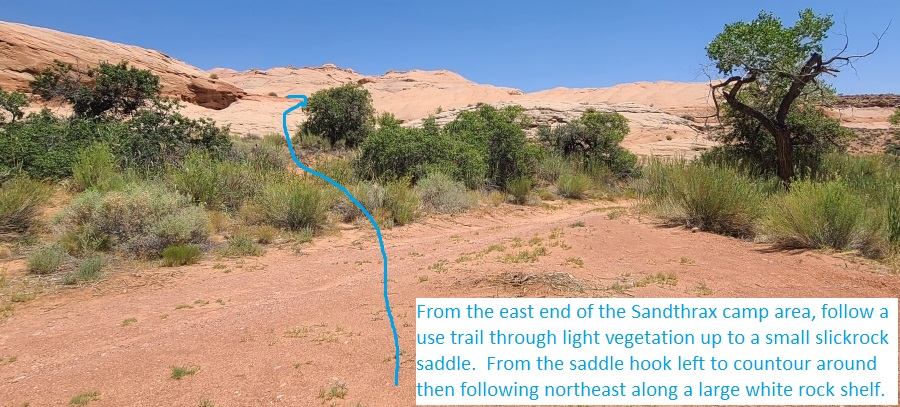
The Approach:
From From the Sandthrax
camp area (lSandthraxCmp)
walk to the east end of
the Sandthrax camp area,
follow a use trail
through light vegetation
up to a small slickrock
saddle (Sandthrax01).
From the saddle hook
left to contour around
then following northeast
along a large white rock
shelf.
At the end of the white
slickrock shelf
(Sandthrax02) scramble
up to the left going up
moderately steep
slickrock about 400 feet
to where you can turn
right and begin
route-finding northeast
roughly following the
rim of Sandthrax Canyon
on your right
(southeast). There is no
one best way through
this area but the aim is
to route find about 0.6
miles northeast roughly
following the rim of
Sandthrax.
About 0.4 miles along
the rim is a short
narrow ledge to walk
(Sandthrax03) or
you can cross lower
dropping down then up
through a shallow bowl. There is no one
best way through this
route but each time I
have followed this route
we always pass through
this spot. Continue northeast about
0.25 miles to where you
can walk down to the
head of Sandthrax
Canyon.
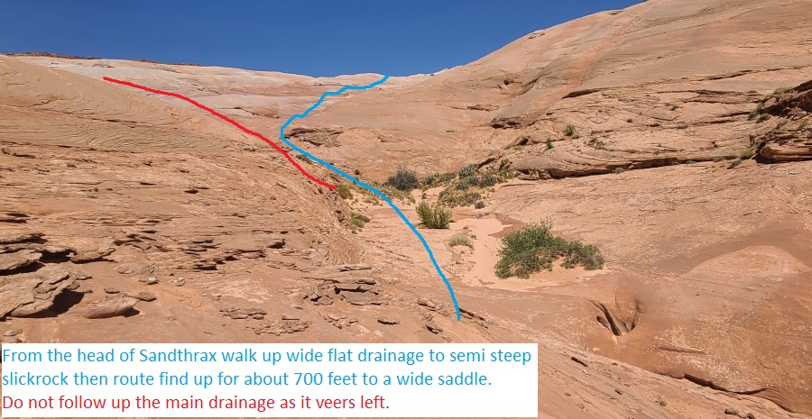
When you get to the head
of Sandthrax (ySandthraxTp)
walk northeast up the
wide flat drainage up
from Sandthrax.
About 200 feet up the
flat Sandthrax drainage
meets semi steep
slickrock (WhoKnew01).
Route find up to the
northeast for about 700
feet to a wide saddle.
Do not follow up the
main drainage as it
veers left (northwest).
From the saddle
(WhoKnew02) walk left
(northwest) about 700
feet up the nose to the
dirt mesa top.
Once on the dirt mesa
top (WhoKnew03) turn
right and walk north
roughly following the
rim.
About 0.75 miles farther
scramble east off the
rim down a rubble pile
weakness (WhoKnew04).
About 250 feet down the
slopes is the top of the
Who Knew drainage
(WhoKnew05). Continue
south-ish wide open
slick rock and shallow
canyon for about 800
feet bypassing a couple
minor drops before
reaching the top of the
canyon (yWhoKnewTp).
The Canyoneering / Technical Section:
From top of Who
Knew Canyon (yWhoKnewTp)
where deeper slot forms,
continue about 170 feet
down canyon bridging
over a couple potholes
then down steeper slot
with galumphing, light
stemming and couple easy
stem style down climbs
of 8 to 10 feet before
the canyon opens up to a
large ledge.
The large ledge
(WhoKnew06) is at the
start of a 125 foot long
slot that can easily be
walked around on the LDC
(east) side then back in
canyon. Playing through
the slot starts with a
drop of about 20 feet
that starts off
moderately sloped and
gradually gets steeper.
In dry conditions the
first drop could be
downclimbed by some but
is best done on handline
with someone above
providing meat anchor.
The remainder of this
slot has 3 easy stem
style downclimbs of 8, 6
then 5 feet followed by
a few potholes to bridge
over to avoid water if
full. One of the
potholes is a semi wide
but is relatively easy
to bridge over.
Where the canyon opens
again is where you would
walk back in canyon
(WhoKnew07) if you
bypassed the slot above.
Down canyon is a series
of large potholes in
very shallow canyon that
are easy to walk around
on the LDC side.
Shortly after is a wide
cross joint and where a
the next slot forms
(WhoKnew08) with easy
galumphing and a couple
short easy downclimbs
down to the first rap.
Portions of this slot
can hold waist deep
water when full.
Rap (dWhoKnewR1)
anchored LDC using a
rock in a solution
pocket about head high
and drops 30 feet.
Continue walking wash
down canyon as the walls
open up to wide wash.
About 350 feet farther
is a shelf (WhoKnew09)
in the wash with loose
overhanging rock. Bypass
RDC scrambling down
rubble slopes.
About 500 feet farther
is a shelf (WhoKnew10)
to get down by bridging
through a short sloped
slot.
A short distance farther
is the start of the next
slot (WhoKnew11) is a
slide of about 15 feet
to a muddy pool that if
full would be a wade of
about 20 feet long
before reaching the next
rap.
Rap 2 (dWhoKnewR2)
anchored using a pinch
point at the top of a
short downclimb about 20
feet back and uses about
80 feet of rope and has
a vertical drop of about
60 feet.
Continue walking for
about 1200 feet to the
end of the wash and into
Butler Canyon (yWhoKnewBt).
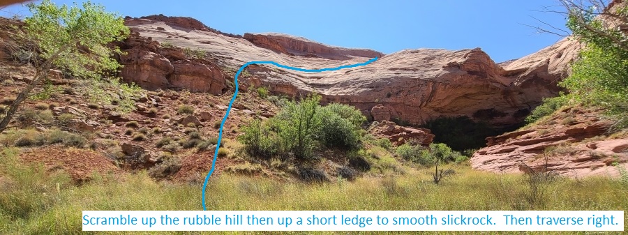
The Exit:
From the
end of Who Knew Canyon (yWhoKnewBt)
turn right and walk
south down Butler Canyon
about 350 feet going
just past a side canyon
on the RDC (west) side.
Just past the side
canyon is the bottom of
a rubble filled hill
(WhoKnew12) on the south
side of a side canyon.
Scramble west up the
rubble hill then up a
short ledge to smooth
slickrock.
Once up on smooth
slickrock (WhoKnew13)
veer right walking north
traversing across a
shallow trough then
continue up to a
slickrock ridge and
follow the ridge west up
toward a large
outcropping.
Once at the base of the
outcropping (WhoKnew14)
contour right (north)
around the base of the
outcropping then wrap
around to continue up to
the west.
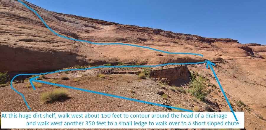
About 300 feet farther
is a huge dirt shelf
(WhoKnew15), walk west
about 150 feet to
contour around the head
of a drainage and walk
west another 350 feet to
a small ledge to walk
across to a short sloped
chute.
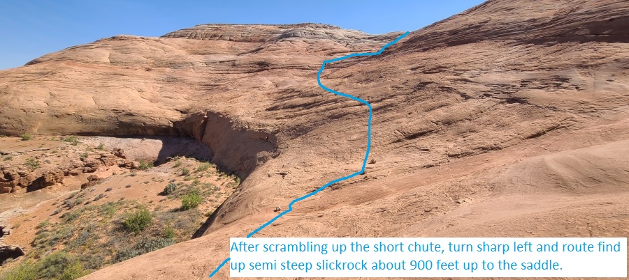
Scramble up the short
chute (WhoKnew16) to
open slickrock then turn
sharp left and route
find (southwest) up semi
steep slickrock about
900 feet up to the
saddle above Sandthrax.
The saddle is the same
one you were at on the
approach.
From the saddle
(WhoKnew02) walk
southwest down semi
steep slickrock down
toward the top of
Sandthrax.
About 200 feet before
the top of Sandthrax
will be flat wash to
walk to the top of the
Sandthrax Slot.
From the top of
Sandthrax (ySandthraxTp)
reverse the approach
route by route finding
southwest along the
north rim of Sandthrax
about 0.75 miles back to
the Sandthrax camp area
(lSandthraxCmp).
(DO NOT drop down into
Sandthrax Canyon).
Downloadable GPX files
available at
BG-Gear Store
(easier than manual entry and a great way to support
Bluugnome).
Waypoint naming convention and map symbol information can be found on the Glossary page.
Elevations are approximate.
BEFORE
manually entering coordinates set your system to WGS84 datum and Lat/Lon hddd.ddddd° coordinate format.
Inconsistent datum's and coordinate formats will result in location errors.
Click to show / expand the list of waypoints below........
| Who Knew Canyon (1) - Approach |
- lSandthraxCmp
Lat/Lon (WGS84): N 38.01645
W -110.53319
Elev: 4,460 Feet
Sandthrax Camp primative camp area.
- Sandthrax01
Lat/Lon (WGS84): N 38.01559
W -110.53028
Elev: NaN Feet
From the east end of the Sandthrax camp area, follow a use trail through light vegetation up to a small slickrock saddle here. From the saddle hook left to contour around then following northeast along a large white rock shelf.
- Sandthrax02
Lat/Lon (WGS84): N 38.01624
W -110.52881
Elev: NaN Feet
At the end of the white slickrock shelf scramble up to the left going up moderately steep slickrock about 400 feet to where you can turn right and begin route-finding northeast roughly following the rim of Sandthrax Canyon on your right (southeast). There is no one best way through this area but the aim is to route find about 0.6 miles northeast roughly following the rim of Sandthrax.
- Sandthrax03
Lat/Lon (WGS84): N 38.02057
W -110.52488
Elev: NaN Feet
Short narrow ledge to walk or you can cross lower dropping down then up through a shallow bowl. There is no one best way through this route but each time I have followed this route we always pass through this spot. Continue northeast about 0.25 miles to where you can walk down to the head of Sandthrax Canyon.
- ySandthraxTp
Lat/Lon (WGS84): N 38.02198
W -110.52064
Elev: 4,790 Feet
Top entry for Sandthrax Canyon in a large flat area at the top of a narrow slot.
To drop into Sandthrax, walk southwest down toward the slot.
To go to Who Knew Canyon, walk northeast up the wide flat drainage up from Sandthrax.
To continue the exit from Who Knew Canyon reverse the approach route by route finding southwest along the north rim of Sandthrax about 0.75 miles back to the Sandthrax camp area. (DO NOT drop down into Sandthrax Canyon)
- WhoKnew01
Lat/Lon (WGS84): N 38.02249
W -110.52035
Elev: NaN Feet
Wide flat drainage above Sandthrax meets semi steep slickrock. Route find up to the northeast for about 700 feet to a wide saddle. Do not follow up the main drainage as it veers left (northwest).
- WhoKnew02
Lat/Lon (WGS84): N 38.02389
W -110.51859
Elev: 4,970 Feet
Saddle at the very top of the Sandthrax drainage.
To go to Who Knew, walk left (northwest) up the nose about 700 feet to the dirt mesa top.
To exit from Who Knew, walk southwest down semi steep slickrock down toward the top of Sandthrax.
- WhoKnew03
Lat/Lon (WGS84): N 38.02577
W -110.51957
Elev: 5,034 Feet
Once at the mesa top in rolling desert, turn right and walk north roughly following the rim.
- WhoKnew04
Lat/Lon (WGS84): N 38.03482
W -110.51373
Elev: 5,080 Feet
Scramble east off the rim down a rubble pile weakness.
- WhoKnew05
Lat/Lon (WGS84): N 38.03446
W -110.51310
Elev: 5,010 Feet
Top of the Who Knew drainage. Continue south-ish wide open slick rock and shallow canyon for about 800 feet bypassing a couple minor drops.
- yWhoKnewTp
Lat/Lon (WGS84): N 38.03243
W -110.51341
Elev: 4,860 Feet
Top of Who Knew where deeper slot forms. Continue about 170 feet down canyon bridging over a couple potholes then down steeper slot with galumphing, light stemming and couple easy stem style down climbs of 8 to 10 feet before the canyon opens up to a large ledge.
|
| Who Knew Canyon (2) - The Canyon |
- yWhoKnewTp
Lat/Lon (WGS84): N 38.03243
W -110.51341
Elev: 4,860 Feet
Top of Who Knew where deeper slot forms. Continue about 170 feet down canyon bridging over a couple potholes then down steeper slot with galumphing, light stemming and couple easy stem style down climbs of 8 to 10 feet before the canyon opens up to a large ledge.
- WhoKnew06
Lat/Lon (WGS84): N 38.03194
W -110.51338
Elev: NaN Feet
Large ledge at the start of a 125 foot long slot that can easily be walked around on the LDC (east) side then back in canyon. Playing through the slot starts with a drop of about 20 feet that starts off moderately sloped and gradually gets steeper. In dry conditions the first drop could be downclimbed by some but is best done on handline with someone above providing meat anchor. The remainder of this slot has 3 easy stem style downclimbs of 8, 6 then 5 feet followed by a few potholes to bridge over to avoid water if full. One of the potholes is a semi wide but is relatively easy to bridge over.
- WhoKnew07
Lat/Lon (WGS84): N 38.03160
W -110.51349
Elev: NaN Feet
Open spot where you would walk back in canyon if you bypassed the slot above. Down canyon is a series of large potholes in very shallow canyon that are easy to walk around on the LDC side.
- WhoKnew08
Lat/Lon (WGS84): N 38.03098
W -110.51393
Elev: NaN Feet
Wide cross joint and where a the next slot forms with easy galumphing and a couple short easy downclimbs down to the first rap. Portions of this slot can hold waist deep water when full.
- dWhoKnewR1
Lat/Lon (WGS84): N 38.03061
W -110.51416
Elev: NaN Feet
Rap 1 - Who Knew. Anchored LDC using a rock in a solution pocket about head high and drops 30 feet. Continue walking wash down canyon as the walls open up to wide wash.
- WhoKnew09
Lat/Lon (WGS84): N 38.02965
W -110.51418
Elev: NaN Feet
Shelf in the wash with loose overhanging rock. Bypass RDC scrambling down rubble slopes.
- WhoKnew10
Lat/Lon (WGS84): N 38.02845
W -110.51480
Elev: NaN Feet
Shelf to get down by bridging through a short sloped slot.
- WhoKnew11
Lat/Lon (WGS84): N 38.02808
W -110.51465
Elev: NaN Feet
At the start of this next slot is a slide of about 15 feet to a muddy pool that if full would be a wade of about 20 feet long.
- dWhoKnewR2
Lat/Lon (WGS84): N 38.02793
W -110.51450
Elev: NaN Feet
Rap 2 - Who Knew. Anchored using a pinch point at the top of a short downclimb about 20 feet back and uses about 80 feet of rope and has a vertical drop of about 60 feet.
Continue walking for about 1200 feet to the end of the wash and into Butler Canyon.
- yWhoKnewBt
Lat/Lon (WGS84): N 38.02544
W -110.51245
Elev: 4,430 Feet
Bottom of Who Knew Canyon where it dumps into Butler Canyon. To exit turn right and walk south down Butler about 350 feet going just past a side canyon on the RDC (west) side.
|
| Who Knew Canyon (3) - Exit |
- yWhoKnewBt
Lat/Lon (WGS84): N 38.02544
W -110.51245
Elev: 4,430 Feet
Bottom of Who Knew Canyon where it dumps into Butler Canyon. To exit turn right and walk south down Butler about 350 feet going just past a side canyon on the RDC (west) side.
- WhoKnew12
Lat/Lon (WGS84): N 38.02438
W -110.51301
Elev: 4,420 Feet
Bottom of a rubble filled hill on the south side of a side canyon. Scramble west up the rubble hill then up a short ledge to smooth slickrock.
- WhoKnew13
Lat/Lon (WGS84): N 38.02407
W -110.51381
Elev: NaN Feet
Once up on smooth slickrock here veer right walking north traversing across a shallow trough then continue up to a slickrock ridge and follow the ridge west up toward a large outcropping.
- WhoKnew14
Lat/Lon (WGS84): N 38.02455
W -110.51537
Elev: NaN Feet
Once at the base of the outcropping here contour right (north) around the base of the outcropping then wrap around to continue up to the west.
- WhoKnew15
Lat/Lon (WGS84): N 38.02456
W -110.51640
Elev: NaN Feet
At this huge dirt shelf, walk west about 150 feet to contour around the head of a drainage and walk west another 350 feet to a small ledge to walk across to a short sloped chute.
- WhoKnew16
Lat/Lon (WGS84): N 38.02585
W -110.51666
Elev: NaN Feet
Scramble up the short chute to open slickrock then turn sharp left and route find (southwest) up semi steep slickrock about 900 feet up to the saddle above Sandthrax. The saddle is the same one you were at on the approach.
- WhoKnew02
Lat/Lon (WGS84): N 38.02389
W -110.51859
Elev: 4,970 Feet
Saddle at the very top of the Sandthrax drainage.
To go to Who Knew, walk left (northwest) up the nose about 700 feet to the dirt mesa top.
To exit from Who Knew, walk southwest down semi steep slickrock down toward the top of Sandthrax.
- WhoKnew01
Lat/Lon (WGS84): N 38.02249
W -110.52035
Elev: NaN Feet
Wide flat drainage above Sandthrax meets semi steep slickrock. Route find up to the northeast for about 700 feet to a wide saddle. Do not follow up the main drainage as it veers left (northwest).
- ySandthraxTp
Lat/Lon (WGS84): N 38.02198
W -110.52064
Elev: 4,790 Feet
Top entry for Sandthrax Canyon in a large flat area at the top of a narrow slot.
To drop into Sandthrax, walk southwest down toward the slot.
To go to Who Knew Canyon, walk northeast up the wide flat drainage up from Sandthrax.
To continue the exit from Who Knew Canyon reverse the approach route by route finding southwest along the north rim of Sandthrax about 0.75 miles back to the Sandthrax camp area. (DO NOT drop down into Sandthrax Canyon)
- Sandthrax03
Lat/Lon (WGS84): N 38.02057
W -110.52488
Elev: NaN Feet
Short narrow ledge to walk or you can cross lower dropping down then up through a shallow bowl. There is no one best way through this route but each time I have followed this route we always pass through this spot. Continue northeast about 0.25 miles to where you can walk down to the head of Sandthrax Canyon.
- Sandthrax02
Lat/Lon (WGS84): N 38.01624
W -110.52881
Elev: NaN Feet
At the end of the white slickrock shelf scramble up to the left going up moderately steep slickrock about 400 feet to where you can turn right and begin route-finding northeast roughly following the rim of Sandthrax Canyon on your right (southeast). There is no one best way through this area but the aim is to route find about 0.6 miles northeast roughly following the rim of Sandthrax.
- Sandthrax01
Lat/Lon (WGS84): N 38.01559
W -110.53028
Elev: NaN Feet
From the east end of the Sandthrax camp area, follow a use trail through light vegetation up to a small slickrock saddle here. From the saddle hook left to contour around then following northeast along a large white rock shelf.
- lSandthraxCmp
Lat/Lon (WGS84): N 38.01645
W -110.53319
Elev: 4,460 Feet
Sandthrax Camp primative camp area.
|