Canyoneering Route Description
Sandthrax Canyon - 4A III X
North Wash, Utah
12-30-17, 10 people, 1 Day (Travel time in route 5.5 hours)

Time Required - 4 to 7 hours
Distance - 1.7 miles Total, 0.4 miles Technical
Rappels - 2 Rappels, Longest Rappel 30 feet.
This is an advanced X canyon. Do not under estimate. See
General comments.
Elevation Range - 4460 - 4780 Feet
Shuttle Required - No Miles Vehicle - Passenger
Permit Required - No
Rappelling and anchor gear, Ropes and or pull cords for rappels up
to 30 feet and 30 feet of 1 inch webbing just in case.
The recommended gear for the crux upclimb is a couple number 6 cams
for the first part then a Trango Big Bro 4 for the top portion (a
Big Bro 3 can be used but is pretty maxed out). A good idea is to
have a 40ish foot dynamic rope to belay the first up the upclimb. A
couple etriers may also prove helpful.
Sandthrax Canyon is a short canyon rated as an X canyon due
to high stemming and the risks associated with that. The crux of Sandthrax
Canyon is an off-width upclimb of about 15 feet that starts from 20 feet off the
deck. If you fall, you will likely also fall down what you climbed and the
additional 20 feet below the start ledge. The crux upclimb is generally reported
to be about a 5.10 off-width upclimb and very awkward at that. I tagged along
with a group
with solid skills and was fortunate enough to have a top haul up the upclimb.
Tall people have been able to dynamically lunge over the
top of the crux but this is generally a bad idea as you will be 60 or more
feet off the deck and will need mad skills to lunge over the awkward
semi-featureless top. People have also been able to toss packs or bags up
into the crux to use as a belay for the first person. Doing a toss of some
sort still requires good of-width climbing skills.
Any way you slice it, the crux is not an obstacle to
take lightly. There have been people not able to bass the crux and get stuck
in canyon. Other parties have accidentally dropped into Sandthrax not
knowing where they were which has equally bad outcomes.
Do not descend Sandthrax Canyon if you do not have
people on your team with solid off-width climbing skills and the proper
equipment to protect the climb. The crux upclimb is out of reach for the
skills of many canyoneers.
A couple years prior to my first full trip through
Sandthrax, Malia and I decided to look at Sandthrax during Freeze Fest but
had no intentions of tackling the crux or full canyon. We called our
adventure the Double Ended Halfthrax Sampler. We descended the first 600-ish
feet (leaving a rope set for the upper rappel) then retreated back up
canyon. Then we hiked around to the bottom and upclimbed Sandthrax to the
top of the Crux upclimb (it looks scary from the top too). On the way up the
bottom is a 20 foot tall silo that with effort I was able to stem up leading
to more stemming up to the top of the crux. If you have solid
stemming skills, want to test your ability and just want to lay eyes on the
crux, the Double Ended Halfthrax Sampler may be just the ticket!
Thanks to Tom C. for allowing me to jump on his trip
with an already large group size and me still having knee issues due to
recent surgery. Also thanks to Braden and Jim for teaming up to work
the crux of Sandthrax. They put in a lot of effort teaming up to get past
the crux then providing belay and pack hauling for those who followed.
To get to the Trailhead
From the junction of highways 276 and 95, travel south east on
95 for 2.2 miles to a dirt road on the left (north east) leading
into the Sandthrax primitive camp area (lSandthraxCmp).
Turn left into the camp area then continue east through
Sandthrax camp to park to begin your route.
Warning: Halfway through the Sandthrax
Camp area is a short section of deep soft sand. Evaluate
your vehicles ability to cross this sand before driving in.
If there is ANY doubt, do not drive through. Instead park
the car and walk the remaining 400 feet to the east end of camp.
It is not worth getting stuck in sand just to avoid walking an
extra 400 feet.
To leave the Exit Vehicle / Escape Pod
No exit vehicle is needed. This is done as a loop route.
GPS coordinate information listed at the bottom. For information about waypoint naming and map symbols, refer to the
Glossary page.

Click the links for maps of the route.
Map of the entire route.
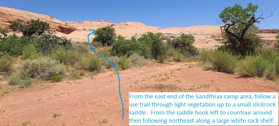
The Approach:
From From the Sandthrax
camp area (lSandthraxCmp)
walk to the east end of
the Sandthrax camp area,
follow a use trail
through light vegetation
up to a small slickrock
saddle (Sandthrax01).
From the saddle hook
left to contour around
then following northeast
along a large white rock
shelf.
At the end of the white
slickrock shelf
(Sandthrax02) scramble
up to the left going up
moderately steep
slickrock about 400 feet
to where you can turn
right and begin
route-finding northeast
roughly following the
rim of Sandthrax Canyon
on your right
(southeast). There is no
one best way through
this area but the aim is
to route find about 0.6
miles northeast roughly
following the rim of
Sandthrax.
About 0.4 miles along the
rim is a short narrow ledge
to walk (Sandthrax03) or you
can cross lower dropping
down then up through a
shallow bowl. There is no
one best way through this
route but each time I have
followed this route we
always pass through this
spot. Continue northeast
about 0.25 miles to where
you can walk down to the
head of Sandthrax Canyon (ySandthraxTp).
The Canyoneering / Technical Section:
From the head of
Sandthrax Canyon (ySandthraxTp)
go down a moderately
challenging downclimb of
about 15 feet then
continue galumphing down
canyon a little over 200
feet to rap 1.
Rap 1 (dSandthraxR1)
anchored LDC from a
pinch point between a
boulder and the canyon
wall and drops about 30
feet down an almost
vertical wall. Continue
galumphing and low
stemming gradually
descending down through
sculpted walls.
Shortly down canyon is a
sharp right-left jog in
the canyon and a partner
assitable downclimb
(Sandthrax04) of about
15 feet. Shortly after
is a skinny spot
followed by an easy
downclimb of about 8
feet. Down canyon
is a short section of
high stemming and as the
canyon becomes very
skinny it is best to go
high not low.
Shortly after is an
elevator down climb
(Sandthrax05) of about
20 feet into a silo like
feature. We found a
handline left here but
staying in the crack
makes the handline
un-needed. Near the
bottom of the downclimb
is a upclimb of about 8
feet up a nose on the
LDC side with an awkward
transition or you can
continue down lower then
climb up about 10 feet
farther down canyon
between tight walls. If
you can make the awkward
transition, staying high
will use less energy.
Continuing down canyon
is moderately easy
stemming to about 40
feet off the deck.
A little over 300 feet
down canyon you can see
a void (Sandthrax06)
below (that looks like
ground but is not) with
a narrow but easy stem
style downclimb into the
void. Downclimb down to
the void and continue
stemming down canyon
once down. It is
possible for tall people
to go very high over
this spot and come down
later but will need to
negotiate down a bombay
like feature.
About 200 feet down
canyon is a silo
(Sandthrax07) where all
but the tallest people
will need to go down
about 15 feet to cross
at a narrow spot by a
scoop / ledge on the LDC
side then stem up at an
angle to go back up
about 15 feet again.
About 100 feet farther
is another silo
(Sandthrax08) to cross
by stemming down about
15 feet and crossing
where narrow by scoops /
ledges on both sides.
Taller people can cross
a little higher using
the scoop on the LDC
side while shorter
people can go a few feet
lower and use the scoop
on the RDC side. Going
back up after crossing
this silo is a little
more difficult / awkward
than the last one.
Shortly after are a few
chock stones large
enough to take a break
on (Sandthrax09) after
crossing a silo. From
the chock stones
continue down canyon
stemming between skinny
walls about 80 feet to
another silo.
This next silo
(Sandthrax10) is where
you will be about 60
feet off the deck that
is overall an awkward
crossing and more
menacing then the
previous silos. Very
tall people can stay
high crossing without
going up or down much.
Most people will need to
drop down about 12 feet
down to a ledge on the
RDC side to cross into
an awkward stem to then
stem up about 20 feet.
After one person is
across they can stem up
and wedge in to belay
those who follow.
Note:
In 2017 there
was a bolted hanger and
piton on the up canyon
end and a bolted hanger
on the down canyon end
of this silo. I assume
these will soon be
removed by the community
as this is a bolt free
area. So do not count on
these being here.
Immediately after this
silo is a stem /
elevator downclimb of
about 60 feet into the
hole for the crux of
Sandthrax Canyon. The
bottom of the downclimb
is at a ledge on the LDC
side still about 20 feet
off the deck large
enough for about 2
people. That ledge is
where you begin
strategizing your plan
for getting up the crux
upclimb.
The Sandthrax Crux
(Sandthrax11Crx) starts
from a ledge on the LDC
side at the bottom of
the upclimb and is about
20 feet off the deck
with twisted winding
walls with protrusions
sure to beat you up if
you fall in. To start
the upclimb, you stem
over the hole and
awkwardly get into an
off-width crack on the
RDC side. The 15 foot
upclimb has the bottom
very slightly over
hanging with a flat
smooth outward flaring
LDC wall and a smooth
RDC wall that prevents
full on stemming making
it an off-width upclimb.
About 2/3 of the way up,
the crack narrows more
and becomes more
difficult. Due to the
slight overhang of the
first part, if you fell
you would also drop down
into the 20 foot hole
below the start ledge.
Note: Recommended
gear is a couple number
6 cams for the first
part then a Trango Big
Bro 4 for the top
portion (a Big Bro 3 can
be used but is pretty
maxed out).
After the crux, continue
down canyon with
moderately difficult
stemming slowly sweeping
down then back up again
as you go past a huge
and pretty conchoidal
fracture along the LDC
wall. About 300
feet down canyon is is
rap 2.
Rap 2 (dSandthraxR2)
anchored RDC up high
from a small bridge in a
solution pocket and
drops about 20 feet.
Note: This rap can be up
and down climbed by
bridging over the drop
then stemming the
vertical section about 8
feet down canyon.
Bridging the drop puts
you in a position to
fall 40 feet or so if
you slip. Upclimbing for
some reason feels less
dangerous than
downclimbing.
Note:
In 2017 we found a piton
anchor which may be
removed in the future.
Walk down canyon about
150 feet to a short
section of easy
galumphing / stemming
with a few not very wide
silos with good features
making them easy to stem
over. About 100 feet of
stemming leads to a stem
style downclimb at the
end and the last of the
technical section (ySandthraxBt).
The Exit:
From the
end of the technical
section (ySandthraxBt)
the canyon opens up
after a stem down climb
of about 20 feet. To
exit walk the wide wash
about 0.3 miles back to
the Sandthrax camp area
(lSandthraxCmp).
Downloadable GPX files
available at
BG-Gear Store
(easier than manual entry and a great way to support
Bluugnome).
Waypoint naming convention and map symbol information can be found on the Glossary page.
Elevations are approximate.
BEFORE
manually entering coordinates set your system to WGS84 datum and Lat/Lon hddd.ddddd° coordinate format.
Inconsistent datum's and coordinate formats will result in location errors.
Click to show / expand the list of waypoints below........
| Sandthrax (1) - Approach |
- lSandthraxCmp
Lat/Lon (WGS84): N 38.01645
W -110.53319
Elev: 4,460 Feet
Sandthrax Camp primative camp area.
- Sandthrax01
Lat/Lon (WGS84): N 38.01559
W -110.53028
Elev: NaN Feet
From the east end of the Sandthrax camp area, follow a use trail through light vegetation up to a small slickrock saddle here. From the saddle hook left to contour around then following northeast along a large white rock shelf.
- Sandthrax02
Lat/Lon (WGS84): N 38.01624
W -110.52881
Elev: NaN Feet
At the end of the white slickrock shelf scramble up to the left going up moderately steep slickrock about 400 feet to where you can turn right and begin route-finding northeast roughly following the rim of Sandthrax Canyon on your right (southeast). There is no one best way through this area but the aim is to route find about 0.6 miles northeast roughly following the rim of Sandthrax.
- Sandthrax03
Lat/Lon (WGS84): N 38.02057
W -110.52488
Elev: 4,780 Feet
Short narrow ledge to walk or you can cross lower dropping down then up through a shallow bowl. There is no one best way through this route but each time I have followed this route we always pass through this spot. Continue northeast about 0.25 miles to where you can walk down to the head of Sandthrax Canyon.
- ySandthraxTp
Lat/Lon (WGS84): N 38.02198
W -110.52064
Elev: 4,790 Feet
Top entry for Sandthrax Canyon in a large flat area at the top of a narrow slot.
To drop into Sandthrax, go down a moderately challenging downclimb of about 15 feet then continue galumphing down canyon.
To go to Who Knew Canyon, walk northeast up the wide flat drainage up from Sandthrax.
To continue the exit from Who Knew Canyon reverse the approach route by route finding southwest along the north rim of Sandthrax about 0.75 miles back to the Sandthrax camp area. (DO NOT drop down into Sandthrax Canyon)
|
| Sandthrax (2) - Canyon and Exit |
- ySandthraxTp
Lat/Lon (WGS84): N 38.02198
W -110.52064
Elev: 4,790 Feet
Top entry for Sandthrax Canyon in a large flat area at the top of a narrow slot.
To drop into Sandthrax, go down a moderately challenging downclimb of about 15 feet then continue galumphing down canyon.
To go to Who Knew Canyon, walk northeast up the wide flat drainage up from Sandthrax.
To continue the exit from Who Knew Canyon reverse the approach route by route finding southwest along the north rim of Sandthrax about 0.75 miles back to the Sandthrax camp area. (DO NOT drop down into Sandthrax Canyon)
- dSandthraxR1
Lat/Lon (WGS84): N 38.02167
W -110.52133
Elev: NaN Feet
Rap 1 - Sandthrax. Anchored LDC from a pinch point between a boulder and the canyon wall and drops about 30 feet down an almost vertical wall. Continue galumphing and low stemming gradually descending down through sculpted walls.
- Sandthrax04
Lat/Lon (WGS84): N 38.02167
W -110.52158
Elev: NaN Feet
Sharp right-left jog in the canyon and a partner assitable downclimb of about 15 feet. Shortly after is a skinny spot followed by an easy downclimb of about 8 feet. Down canyon is a short section of high stemming and as the canyon becomes very skinny it is best to go high not low.
- Sandthrax05
Lat/Lon (WGS84): N 38.02152
W -110.52192
Elev: NaN Feet
Elevator down climb of about 20 feet into a silo like feature. We found a handline left here but staying in the crack makes the handline un-needed. Near the bottom of the downclimb is a upclimb of about 8 feet up a nose on the LDC side with an awkward transition or you can continue down lower then climb up about 10 feet farther down canyon between tight walls. If you can make the awkward transition, staying high will use less energy.
Continuing down canyon is moderately easy stemming to about 40 feet off the deck.
- Sandthrax06
Lat/Lon (WGS84): N 38.02087
W -110.52294
Elev: NaN Feet
Can see a void below (that looks like ground but is not) with a narrow but easy stem style downclimb into the void. Downclimb down to the void and continue stemming down canyon once down. It is possible for tall people to go very high over this spot and come down later but will need to negotiate down a bombay like feature.
- Sandthrax07
Lat/Lon (WGS84): N 38.02044
W -110.52338
Elev: NaN Feet
Silo where all but the tallest people will need to go down about 15 feet to cross at a narrow spot by a scoop / ledge on the LDC side then stem up at an angle to go back up about 15 feet again.
- Sandthrax08
Lat/Lon (WGS84): N 38.02021
W -110.52362
Elev: NaN Feet
Another silo to cross by stemming down about 15 feet and crossing where narrow by scoops / ledges on both sides. Taller people can cross a little higher using the scoop on the LDC side while shorter people can go a few feet lower and use the scoop on the RDC side. Going back up after crossing this silo is a little more difficult / awkward than the last one.
- Sandthrax09
Lat/Lon (WGS84): N 38.02006
W -110.52385
Elev: NaN Feet
A few chock stones large enough to take a break on after crossing a silo. From the chock stones continue down canyon stemming between skinny walls about 80 feet to another silo.
- Sandthrax10
Lat/Lon (WGS84): N 38.01993
W -110.52405
Elev: NaN Feet
Silo where you will be about 60 feet off the deck that is overall an awkward crossing and more menacing then the previous silos. Very tall people can stay high crossing without going up or down much. Most people will need to drop down about 12 feet down to a ledge on the RDC side to cross into an awkward stem to then stem up about 20 feet. After one person is across they can stem up and wedge in to belay those who follow.
Note: In 2017 there was a bolted hanger and piton on the up canyon end and a bolted hanger on the down canyon end of this silo. I assume these will soon be removed by the community as this is a bolt free area. So do not count on these being here.
Immediately after this silo is a stem / elevator downclimb of about 60 feet into the hole for the crux of Sandthrax Canyon. The bottom of the downclimb is at a ledge on the LDC side still about 20 feet off the deck large enough for about 2 people. That ledge is where you begin strategizing your plan for getting up the crux upclimb.
- Sandthrax11Crx
Lat/Lon (WGS84): N 38.01978
W -110.52437
Elev: NaN Feet
Sandthrax Crux starts from a ledge on the LDC side at the bottom of the upclimb is about 20 feet off the deck with twisted winding walls with protrusions sure to beat you up if you fall in. To start the upclimb, you stem over the hole and awkwardly get into an off-width crack on the RDC side. The 15 foot upclimb has the bottom very slightly over hanging with a flat smooth outward flaring LDC wall and a smooth RDC wall that prevents full on stemming making it an off-width upclimb. About 2/3 of the way up, the crack narrows more and becomes more difficult. Due to the slight overhang of the first part, if you fell you would also drop down into the 20 foot hole below the start ledge.
Note: Recommended gear is a couple number 6 cams for the first part then a Trango Big Bro 4 for the top portion (a Big Bro 3 can be used but is pretty maxxed out).
After the crux, continue down canyon with moderately difficult stemming slowly sweeping down then back up again as you go past a huge and pretty conchoidal fracture along the LDC wall.
- dSandthraxR2
Lat/Lon (WGS84): N 38.01923
W -110.52519
Elev: NaN Feet
Rap 2 - Sandthrax Canyon. Anchored RDC up high from a small bridge in a solution pocket and drops about 20 feet.
Note: This rap can be up and down climbed by bridging over the drop then stemming the vertical section about 8 feet down canyon. Bridging the drop puts you in a position to fall 40 feet or so if you slip. Upclimbing for some reason feels less dangerous than downclimbing.
Note: In 2017 we found a piton anchor which may be removed in the future.
Walk down canyon about 150 feet to a short section of easy galumphing / stemming with a few not very wide silos with good features making them easy to stem over. About 100 feet of stemming leads to a stem style downclimb at the end and the last of the technical section.
- ySandthraxBt
Lat/Lon (WGS84): N 38.01847
W -110.52616
Elev: 4,535 Feet
Bottom of the Sandthrax route where the canyon opens up after a stem down climb of about 20 feet. To exit walk the wide wash about 0.3 miles back to the Sandthrax camp area.
- lSandthraxCmp
Lat/Lon (WGS84): N 38.01645
W -110.53319
Elev: 4,460 Feet
Sandthrax Camp primative camp area.
|