Canyoneering Route Description
Chamber of the Basilisk - 3A I
Goblin Valley State Park, Utah
2012-09-16, 2 people, 1 Day (Travel time in route 2.5 hours)
 -- time includes a lot of wandering around.
2016-03-06, 2 people, 1 Day (Travel time in route 2.5 hours)
-- time includes a lot of wandering around.
Time Required - 1 to 2 hours
Distance - 1.75 miles Total, 450 feet Technical
Rappels - 1 Rappels, Longest Rappel 100 feet.
Elevation Range - 5010 - 4840 Feet
Shuttle Required - No Vehicle -
Passenger
Permit Required - Yes
Rappelling and anchor gear, Ropes and or pull cords for rappels up
to 100 feet and 20 feet of 1 inch webbing for sling placement.
Chamber of the Basilisk qualifies as more of a hike
with ropes. The entire route is non-technical except for the one
rappel down into the chamber. This chamber is very scenic and worth
the visit. If you are there at a time of day with good lighting you
may be able to get awesome pictures from down in the chamber.
The Chamber of the Basilisk is in Goblin Valley State
park and is accessed from the main parking area where everyone hikes around
to go play around in the goblins. From the parking area you will make your
way to a small white dome you can see about 0.3 miles to the southeast. From
the dome, route find your way east up through the maze of hoodoos and
goblins to the top of Chamber of the Basilisk. Rap down into the chamber.
From the chamber you will climb up a rubble pile to get out to the back
(east) side of the range. The exit route just walks open desert north then
east around the range and back to the parking spot.
The first 2 times I did Chamber of the Basilisk it was
difficult to find a simple easy to follow route into Chamber of the Basilisk
so there was a lot of wandering around in the maze of goblins. However,
wondering around this area is pretty fun, so its not a big deal to wander
around a bit. Written directions will be very difficult to properly convey
the best route from the trailhead up to Chamber of the Basilisk. The
approach portion of this route description has a lot of pictures which
should make navigating your way through this maze relatively easy. Even with
pictures this can be a complicated place to navigate so be prepared for some
head scratching and fun scrambling around.
My first two trips took about 2.5 hours each time since
we were not in a hurry and we wandered around a lot looking for the place.
Most groups will likely take about 1.5 to 2 hours at a slow pace.
A permit is required and can be obtained on the drive
in at the front gate / visitor center for Goblin Valley State Park. There is
also an entrance fee for Goblin Valley which was $7 when I was there.
The length of the rap is under 100 feet. Unfortunately
I forgot to take an accurate measurement both times I was there! Uhg!.
Rather than guestimate how much shorter than 100 feet the rap is I prefer to
slightly over rate the length so no one gets there with too short a rope.
this is why I call the rap 100 feet knowing it may be a bit shorter.
To get to the Trailhead
From the junction of Highways 24 and 95 in Hanksville Utah,
drive north on Highway 24 about 19.5 miles to a turn off on the
left (west) onto Temple Mountain Road (exGoblinValley).
The signs marking this turn for Goblin Valley State park are
large and easy to see.
Turn left to go to Goblin Valley State Park and drive 5.15 miles
to a left (south) turn onto Goblin Valley Road (exGoblinVlyRd).
In 6.5 miles you will be at the entrance for Goblin Valley State
Park (GoblinVlyGate). This is where you can stop in the
visitor center to pick up a permit.
0.5 miles after the entrance / visitor center is a tee in Goblin
Valley Road (GobliTee). Turn left and drive 0.7 miles to
the a large parking lot where you will start the route (tGoblinVly).
To leave the Exit Vehicle / Escape Pod
No exit vehicle is needed. This is done as a loop route.
GPS coordinate information listed at the bottom. For information about waypoint naming and map symbols, refer to the
Glossary page.

Click the links for maps of the route.
Map of the drive into the route.
Map of the entire route.
Map of the approach (zoomed in).
The Approach:
The route starts where
stairs drop down from
the parking lot next to
some covered picnic
tables (tGoblinVly).
Before leaving the
trailhead to go to
Chamber of the Basilisk
take a look at the hills
about 0.4 miles to the
southeast. Note the
tallest wide white peak
then look to the right
and note the second
tallest white peak. Look
closely and notice a
small white capped dome
down in the reddish
brown hills below and
slightly right of the
second tallest white
peak. To begin the route
walk down the stairs
then route find your way
southeast toward the
small white capped dome.
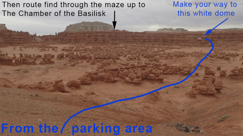 First make your way to the small white dome.
As you drop down and
walk the valley floor
toward the white dome
you will loose sight of
it due to rolling
terrain. About
0.24 miles for the
parking lot the route
goes over a small mound
(BasiliskRP01). Continue
southeast about 300 feet
to a wash cutting
through the reddish
brown rock band. The
reddish brown rock band
will likely block your
view of the white dome
in this area.
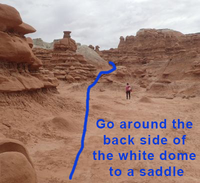 Go around the back (south)
side of the dome then up to
a small saddle.
Go around the back (south)
side of the dome then up to
a small saddle.
When you get to where
the wash cuts through
the reddish brown cliff
band (BasiliskRP02) you
can see the white capped
dome again. Walk about
400 feet southeast to
the white capped dome
then route find your way
around the right (south)
side of the dome to a
saddle at the base of
the dome.
From the saddle behind
the white dome
(BasiliskRP03) look east
and note a very tall
goblin spire about 300
feet away. Note a
cave like hole down low
and left of the tall
spire. Route find
your way east over two
the cave like hole then
around to the right of
it and scramble a few
feet up to a notch.
 Walk past the cave like hole
then
up to a small notch to pass
through.
Walk past the cave like hole
then
up to a small notch to pass
through.
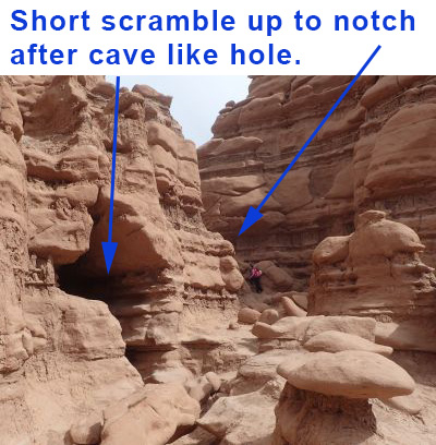 Walk past the cave like hole
then
up to a small notch to pass
through.
Walk past the cave like hole
then
up to a small notch to pass
through.
From the notch
(BasiliskRP04) after the
cave like hole, walk
east up what can loosely
be called a wash for a
little over 200 feet to
where the wash goes
through a small pass by
the base of a series of
tall hoodoo / goblins in
a row.
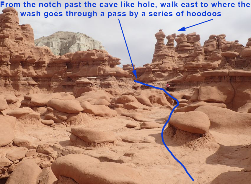 A short distance from
the notch note a series
of tall hoodoos and make
your way over to a pass
near the base of them.
A short distance from
the notch note a series
of tall hoodoos and make
your way over to a pass
near the base of them.
When you get to the pass
near the base of the
tall hoodoos
(BasiliskRP05) look east
where the route opens up
into a wide open flat
valley like area. Walk
about 200 feet northeast
over to where you can
scramble up into the
hoodoos (BasiliskRP06).
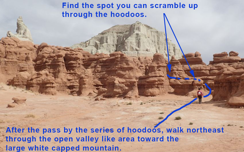 Walk across the open
valley like area to where
you can scramble up into the
hoodoos as shown.
Walk across the open
valley like area to where
you can scramble up into the
hoodoos as shown.
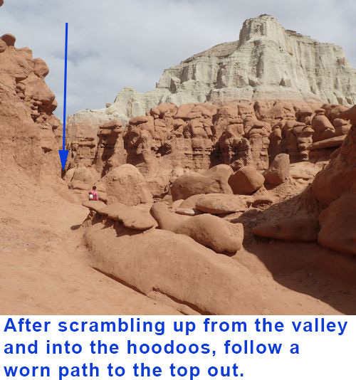
When you scramble up
into the hoodoos
(BasiliskRP06) you will
find a worn path to
follow up to the top
out.
From where the path tops
out (yBasiliskTp) you
are ready to descend to
the rappel in point for
Chamber of the Basilisk.
The Canyoneering / Technical Section:
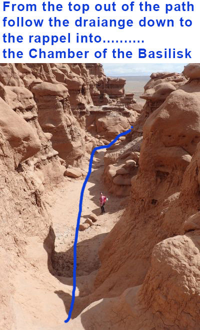
From the top out
of the path (yBasiliskTp)
drop down the other side
walking down the hill
and following a drainage
down to the southeast.
Make your way down the
drainage to the spot to
rappel into the chamber
about 180 feet away.
This drainage has some
walking and some
scrambling over large
boulders and as you get
closer to the rappel you
will duck and go under
some boulders.
Rap 1 (dBasilisk-R1) is
anchored from rocks
protruding from the
ground and drops about
100 feet mostly free
hanging down into a huge
chamber. At the bottom
of the rappel you are in
a huge chamber with
holes in the side.
To exit, scramble about
80 feet up the slope out
of the chamber.
The Exit:
After
scrambling up out of the
chamber you will be on
the other side of the
hills facing out
(yBasiliskBt) toward
open desert.
Follow use trails east
down the slopes then
north to follow along
the base of the cliff
side.
About 0.5 miles north is
the northern end of the
cliff base
(BasiliskRP07). From
here follow use trails
to the left (west) going
back toward the parking
area.
About 700 feet west the
use trails will leave
the wash (BasiliskRP09)
and follow use trails up
the RUC (north) side of
the wash. Follow the use
trails through hills
back to the parking
area.
About 0.3 miles farther
you will be at the
northern end of the
parking lot
(BasiliskRP10).
Find your car to
complete the route.
Downloadable GPX files
available at
BG-Gear Store
(easier than manual entry and a great way to support
Bluugnome).
Waypoint naming convention and map symbol information can be found on the Glossary page.
Elevations are approximate.
BEFORE
manually entering coordinates set your system to WGS84 datum and Lat/Lon hddd.ddddd° coordinate format.
Inconsistent datum's and coordinate formats will result in location errors.
Click to show / expand the list of waypoints below........
| Chamber of the Basilisk (1) - Drive in to Trailhead |
- exGoblinValley
Lat/Lon (WGS84): N 38.63072
W -110.56675
Elev: NaN Feet
Exit for Temple Mountain Road off highway 24. This is also the turn off for Goblin Valley State Park..
- exGoblinVlyRd
Lat/Lon (WGS84): N 38.65338
W -110.65455
Elev: NaN Feet
Exit where Goblin Valley Raod leaves Temple Mountain Road and goes west to Goblin Valley State Park.
- GoblinVlyGate
Lat/Lon (WGS84): N 38.57811
W -110.70756
Elev: 0 Feet
Entrance to Goblin Valley State Park. Visitor center and fee entrance gate here.
- GobliTee
Lat/Lon (WGS84): N 38.57164
W -110.70899
Elev: 0 Feet
Tee in the Gobblin Valley Road. Turn left (southeast) at the tee to go to the main parking area.
- tGoblinVly
Lat/Lon (WGS84): N 38.56412
W -110.70323
Elev: 4,965 Feet
The is where the trail starts down some stairs by covered tables near the parking area and drops down into the goblins.
Before leaving the trailhead to go to Chamber of the Basilisk take a look at the hills about 0.4 miles to the southeast. Note the tallest wide white peak then look to the right and not the second tallest white peak. Look closely and notice a small white capped dome down in the reddish brown hills below and slightly right of the second talles white peak. To begin the route walk down the stairs then route find your way southeast toward the small white capped dome.
|
| Chamber of the Basilisk (2) - Approach and Canyon |
- tGoblinVly
Lat/Lon (WGS84): N 38.56412
W -110.70323
Elev: 4,965 Feet
The is where the trail starts down some stairs by covered tables near the parking area and drops down into the goblins.
Before leaving the trailhead to go to Chamber of the Basilisk take a look at the hills about 0.4 miles to the southeast. Note the tallest wide white peak then look to the right and not the second tallest white peak. Look closely and notice a small white capped dome down in the reddish brown hills below and slightly right of the second talles white peak. To begin the route walk down the stairs then route find your way southeast toward the small white capped dome.
- BasiliskRP01
Lat/Lon (WGS84): N 38.56177
W -110.70026
Elev: NaN Feet
The route over toward Chamber of the Basilisk goes over a small mound here. Continue southeast about 300 feet to a wash cutting through the reddish brown rock band. The reddish brown rock band will likely block your view of the white dome in this area.
- BasiliskRP02
Lat/Lon (WGS84): N 38.56123
W -110.69956
Elev: NaN Feet
This is where washes cut through part of the reddish brown rock band. From here you can see the white capped dome you could see from the parking lot. Walk about 400 feet southeast to the white capped dome. As you get to the dome route find your way around the right (south) side of the dome to a saddle at the base of the dome.
- BasiliskRP03
Lat/Lon (WGS84): N 38.56071
W -110.69834
Elev: NaN Feet
A saddle on back (southeast) side of the white dome. From the saddle look east and note a very tall goblin spire about 300 feet away. Note a cave like hole down low and left of the tall spire. Route find your way east over two the cave like hole then around to the right of it and scramble a few feet up to a saddle / notch.
- BasiliskRP04
Lat/Lon (WGS84): N 38.56135
W -110.69787
Elev: 4,975 Feet
Notch to scramble up to just after passing a small cave like hole. From this notch walk east up what can loosely be called a wash for a little over 200 feet to where the wash goes through a small pass by the base of a series of tall hoodoo / goblins in a row.
- BasiliskRP05
Lat/Lon (WGS84): N 38.56141
W -110.69712
Elev: NaN Feet
Wash goes through a small pass by the base of a series of tall hoodoo / goblins in a row. On the other side of this pass the wash opens up into a wide open flat valley like area. Walk about 200 feet northeast over to where you can scramble up into the hoodoos. It is difficult to describe this in writting, use pictures and or GPS.
- BasiliskRP06
Lat/Lon (WGS84): N 38.56168
W -110.69648
Elev: 5,019 Feet
Spot on the northeast side of a wide valley like area to scramble up 6 or 8 feet to walk up a path through the hoodoos. Walk about 70 feet up the path to where it tops out.
- yBasiliskTp
Lat/Lon (WGS84): N 38.56186
W -110.69641
Elev: 5,009 Feet
Path up out of the valley tops out here. Drop down the other side walking down the hill and following another wash like spot down to the southeast. Make your way down the drainage to the spot to rappel into the chamber about 180 feet away. This drainage has some walking and some scrambling over large boulders and as you get closer to the rappel you will duck and gounder some boulders.
- dBasilisk-R1
Lat/Lon (WGS84): N 38.56152
W -110.69587
Elev: 4,947 Feet
Rap 1 - Chamber of the Basilisk anchored from rocks protruding from the ground and drops about 100 feet mostly free hanging down into a huge chamber. At the bottom of rappel you are in a huge chamber with holes in the side. Scramble about 80 feet up the slope out of the chamber.
- yBasiliskBt
Lat/Lon (WGS84): N 38.56142
W -110.69506
Elev: 4,900 Feet
Exit of the Chamber of the Basilisk. After scrambling up out of the chamber follow use trails east down the slopes then north to follow along the base of the clif side.
|
| Chamber of the Basilisk (3) - Exit |
- yBasiliskBt
Lat/Lon (WGS84): N 38.56142
W -110.69506
Elev: 4,900 Feet
Exit of the Chamber of the Basilisk. After scrambling up out of the chamber follow use trails east down the slopes then north to follow along the base of the clif side.
- BasiliskRP07
Lat/Lon (WGS84): N 38.56829
W -110.69379
Elev: NaN Feet
Northern end of the cliff base. From here follow use trails to the left (west) going back toward the parking area.
- BasiliskRP08
Lat/Lon (WGS84): N 38.56879
W -110.69733
Elev: NaN Feet
Fork in the wash. Follow southwest up the left fork to contiue back to the parking area.
- BasiliskRP09
Lat/Lon (WGS84): N 38.56723
W -110.69850
Elev: NaN Feet
Leave the wash here and follow use trails up the RUC (north) side of the wash. Follow the use trails through hills back to the parking area.
- BasiliskRP10
Lat/Lon (WGS84): N 38.56519
W -110.70271
Elev: NaN Feet
Trails meat teh eastern end of the Goblin Valley parking area here.
- tGoblinVly
Lat/Lon (WGS84): N 38.56412
W -110.70323
Elev: 4,965 Feet
The is where the trail starts down some stairs by covered tables near the parking area and drops down into the goblins.
Before leaving the trailhead to go to Chamber of the Basilisk take a look at the hills about 0.4 miles to the southeast. Note the tallest wide white peak then look to the right and not the second tallest white peak. Look closely and notice a small white capped dome down in the reddish brown hills below and slightly right of the second talles white peak. To begin the route walk down the stairs then route find your way southeast toward the small white capped dome.
|