Canyoneering Route Description
Stone Dagger Canyon - 3A IV (V)
Capitol Reef National Park, Utah
09-17-16, 5 people, 1 Day (Travel time in route 12.15 hours)
 Cap to canyon to a camp in Spring Canyon
Time Required - 11 to 12 hours car to car. or
8 to 9 hours camp to camp if camped in spring canyon
Distance - 12.2 miles Total, 0.8 miles Technical
Rappels - 4 Rappels, Longest Rappel 140 feet.
Will need 180 foot of rope due to anchor set back from drop.
Elevation Range - 5920 - 7070 Feet
Shuttle Required - No Vehicle - Passenger
Permit Required - Yes
Rappelling and anchor gear, Ropes and or pull cords for rappels up
to 180 feet and 70 feet of 1 inch webbing for sling placement.
Actual larges drop is 140 but the anchor is set back about 40 feet
so 180 feet of rope should be on hand.
Stone Dagger is a great trip for those wanting to get
farther out into the back country of Capitol Reef National Park with a little
technical challenge added to a long day of off trail hiking with scenic views.
The approach to Stone Dagger Canyon is off the beaten path with little signs of
previous passage. A GPS or good map reading skills are required for this route.
Thanks to John D. for inviting us to join in on checking this place out.
There was water on our visit but all water was
avoidable with easy galumphing or stemming.
Stone Dagger was named after a large boulder near the
end of the canyon wedge between the walls with a pointed bottom. We all
joked about it looking like it was a huge dagger poised to fall on anyone
who dared pass under it. I forget who actually uttered the words Stone
Dagger first.
To get to the Trailhead
From the junction of highways 12 and 24, drive east on highway
24 toward Capitol Reef for 6.8 miles to a turn off on the left
for Chimney Rock Trail.
OR
From the visitor center in Capitol Reef, drive 3 miles east on
highway 24 to a turn off on the right for Chimney Rock Trail.
The turn off is paved and runs a couple hundred feet to the
parking area at the Chimney Rock Trailhead (tChimneyRock).
To leave the Exit Vehicle / Escape Pod
No exit vehicle is needed. This is done as a loop route.
GPS coordinate information listed at the bottom. For information about waypoint naming and map symbols, refer to the
Glossary page.

Click the links for maps of the route.
Map of the entire route.
Map zoomed in of later part of approach.
Map of the technical section.
The Approach:
From the parking lot (tChimneyRock)
follow the Chimney Rock
trail northeast about
150 feet to where a
small trail branches off
(wSmokStakRP-01) to the
left (northwest).
To go to Stone Dagger or
A-Door-Able canyons,
continue northeast on
the main trail.
About 0.5 miles down the
trail is a trail
junction (jChim-Sprg-cyn)
on the Chimney Rock Loop
Trail. To go to
Stone Dagger or
A-Door-Able canyons
follow the trail
northeast and not the
trail to the south
leading to Chimney Rock.
About 350 feet east the
trail will cross a
drainage then continue
east and roughly follow
along a drainage below
also going east.
About 0.9 miles farther
is a spot on the Chimney
Rock Loop Trail where
use trails leave
(jChim-SprgCyn2) the
main trail and drop
north down into the
large drainage about 90
feet away. To go
to Stone Dagger or
A-Door-Able Canyons,
leave the main trail and
follow use trails about
90 feet down into the
major drainage below.
Once in the main
drainage below
(wSmokStakRP-21)
continue east down the
wash.
About 0.27 miles farther
a large side canyon
joins in from the north
(wSmokStakRP-20).
Continue east down the
wash.
About 0.55 miles farther
is the bottom exit of
Smokestack Canyon (ySmokStak-Bt)
on the left (northish),
continue east in the
wash.
About 0.3 miles farther
a side canyon joins in
(ChimRkCyn30) from the
north with two large
cottonwood trees just
west of where the side
canyon joins in.
Continue east down the
wash.
About 0.3 miles farther
is a confluence where
Chimney Rock Canyon
meets Spring Canyon with
wooden signs posted.
To go to Stone Dagger or
A-Door-Able canyons go
north up Spring Canyon.
About 0.5 miles north up
Spring Canyon is a large
drainage (jA-Door-Able)
on the right (northeast)
side of Spring Canyon.
Leave Spring Canyon and
go northeast up this
large drainage.
About 250 feet up the
drainage is the bottom
of a rubble filled
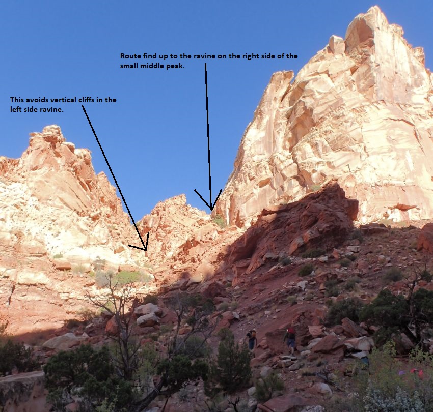
ravine (A-Door01)
leaving the drainage
going up to the
northwest. Note a small
peak in the center of
the ravine and routefind
up the slopes to the
right of that peak. As
you get higher up the
slopes, you will be
going into a smaller
ravine going up the
right side of the center
peak. There are a couple
spots with exposed 4th
class scrambling for a
short distance.
 Note a small
peak in the center of the ravine and routefind up the slopes to the right of
that peak. As you get higher up the slopes, you will be going into a smaller
ravine going up the right side of the center peak. There are a couple spots with
exposed 4th class scrambling for a short distance.
Note a small
peak in the center of the ravine and routefind up the slopes to the right of
that peak. As you get higher up the slopes, you will be going into a smaller
ravine going up the right side of the center peak. There are a couple spots with
exposed 4th class scrambling for a short distance.
Shortly up the slopes on the right of
the ravine the rock gets steeper (A-Door02) requiring more hands and feet
in places. Staying far right seems to be the best route but effort is required
to route find through this convoluted area. There is one spot you will need to
climb 4th class up about 10 feet to continue up.
A few hundred feet farther
is the top out of the small
ravine (A-Door03) on the
right of the peak. Veer left
and scramble down steep
slickrock to the main ravine
below.
Once down in the main ravine
(A-Door04), scramble and
boulder hop northwest up the
ravine.
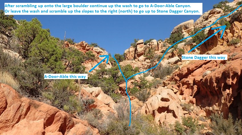
About 500 feet farther up
the ravine is a very large
boulder in the ravine with
ledges on the left to help
scramble up over it. From
the top of the boulder
(A-Door05) you can see the
ravine is getting wider and
the grade becomes more
gentle. To go to Stone
Dagger Canyon continue
northwest about 150 feet
farther up the ravine then
leave the ravine to the
right (north) scrambling up
a series of ledges.
Note:
If
you were going to
A-Door-Able Canyon, you
would continue northwest up
the wash about 375 feet to a
brief top out in the ravine.
 About 150 feet up canyon
of the boulder (jStoneDagger),
leave the drainage and
begin routefinding north
up a series of ledge. On
our visit the route up
the ledges had the
occasional cairn but
they may not remain, so
they should not be
depended on.
About 150 feet up canyon
of the boulder (jStoneDagger),
leave the drainage and
begin routefinding north
up a series of ledge. On
our visit the route up
the ledges had the
occasional cairn but
they may not remain, so
they should not be
depended on.
About 150 feet up canyon
of the boulder (jStoneDagger),
leave the drainage and
begin routefinding north
up a series of ledge. On
our visit the route up
the ledges had the
occasional cairn but
they may not remain, so
they should not be
depended on.
About 200 feet up the
ledges the route gets to
a long section of
scrambling up steep with
slickrock (StoneD01)
where good route finding
is needed.
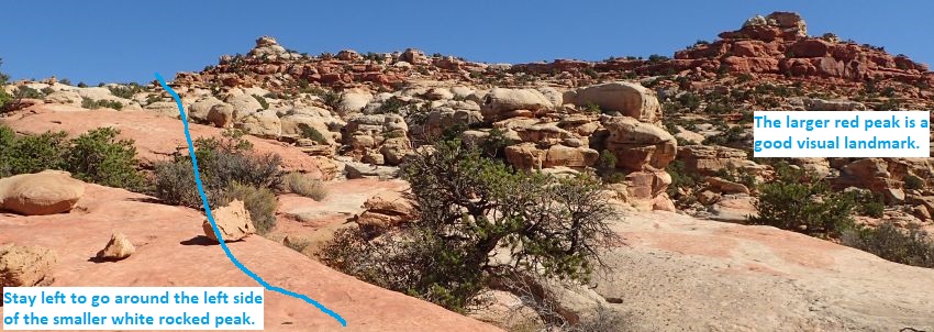
About 500 feet farther
the route begins to
become a little less
steep (StoneD02). From
here you begin to see a
red rock peak about 0.3
miles to the northeast.
Visually follow the
ridge line running left
(west) down from the red
peak to a smaller peak /
outcropping of more
yellow rock. Travel
north to go around the
left (west) side of that
smaller peak /
outcropping.
 Depending on
your route through this section you may come across a 3 legged rock
(StoneD03-3Legs) making for a fun place to hang out for a short break and
admire a large rock you can crawl under that is held up by 3 rock legs.
Depending on
your route through this section you may come across a 3 legged rock
(StoneD03-3Legs) making for a fun place to hang out for a short break and
admire a large rock you can crawl under that is held up by 3 rock legs.
A few hundred feet
farther the route
traverses around the
left (west) side of the
smaller rock outcropping
(StoneD04) noted earlier
for navigation.
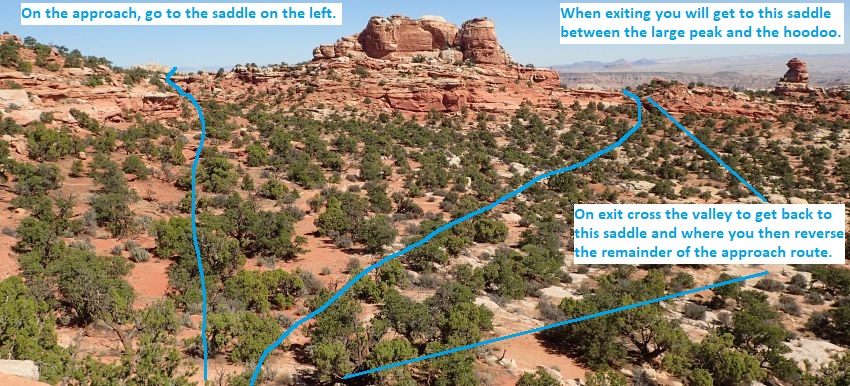
Continue north about 500
feet to a small saddle.
At the small saddle
(StoneD05-Sdle) there
are views into a small
valley like area to the
north. Take note of what
this area looks like as
you will cross this same
point on the exit route
from the canyon.
To go to Stone Dagger
Canyon, drop north down
the slope toward the
valley and veer left
(northwest) to contour
over to a saddle left of
of a large rock hill.
Note and remember the
large hoodoo directly
across the valley to the
northeast, you will be
on that ridge on the
exit from Stone Dagger
Canyon.
 To get up to
the saddle on the left it is easier to stay high and traverse rock
ledges to avoid the cliffs just below the saddle.
To get up to
the saddle on the left it is easier to stay high and traverse rock
ledges to avoid the cliffs just below the saddle.
Once on the next saddle
(StoneD06-Sdle) continue
northwest contouring
around the top of a
drainage then over to
the left (west) side of
a large rock outcropping
about 1000 feet away.
From the large
outcropping
(StoneD07-OutCr)
continue northwest about
0.4 miles to drop down
into the top of Stone
Dagger Canyon. While
traveling toward the
head of the canyon,
continue to make solid
effort to veer left as
the lay of the land
makes you want to veer
right. Conscious effort
is needed to stay left
so you do not
automatically start
wandering off to the
right.
About 0.4 miles farther
the route drops down
into the drainage at the
top of Stone Dagger
Canyon (yStoneDaggerTp).
This drop in is about
150 feet down canyon of
a large shelf in the
wash.
The Canyoneering / Technical Section:
From the drop in
at the top of Stone
Dagger (yStoneDaggerTp)
walk east down canyon
and around a cross joint
pothole on the RDC side
where a short scramble
and a downclimb of about
8 feet gets you back
into the canyon. A
little over 100 feet
down canyon is rap 1.
Rap 1 (dStoneD-R1)
anchored LDC from a
small arch and drops
about 35 feet.
Optionally you can walk
a ledge on the RDC side
to bypass the rap but it
is a bit spicy.
About 80 feet down
canyon is a gently
sloped downclimb
(StoneD08) of about 20
feet. About 60
feet down canyon is rap
2.
Rap 2 (dStoneD-R2) is
anchored from a rock
under a large boulder at
the top of a crack and
drops about 50 feet down
into a deep chamber like
area. Getting started on
this rap is a little
awkward as you get on
rope, worm your way
through the crack over a
large choke stone over
into free hang in a
crack / chamber like
area.
About 50 feet down
canyon is a pretty slot
section (StoneD09) to go
down through starting
with gently sloped
downclimb through swirly
section to a pothole
that can be bridged
over, another gently
sloped downclimb leads
to log and boulder
debris where you can
worm through a hole
under the boulder or go
over boulder and stem
down. After the boulder
is sandy wash walking.
About 150 feet down
canyon is a drop
(StoneD10-PAsst) of
about 12 feet with the
last 5 to 6 feet being
vertical. A partner
assist get the group
down quick and easy with
only the last person
downclimbing with
assistance from below.
The next 900 feet is
mostly easy walking in
long corridor with the
occasional spot to
galumph over water or
debris.
About 900 feet farther
are large boulders
(StoneD11) near end of
vegetated section with 2
easy sloped downclimbs
of about 8 to 10 feet
each. About 150
feet down canyon is rap
3.
Rap 3 (dStoneD-R3)
anchored from a small
tree about 40 feet back
from the lip then drops
about 140 feet with a
large ledge mid way
down. After the rap is
easy walking in long
corridor with a couple
short easy downclimbs
mixed in. A little
over 600 feet down
canyon is rap 4.
Rap 4 (dStoneD-R4)
anchored from tree on
the RDC side and drops
about 35 feet.
Shortly after rap 4 are
some boulders (StoneD12)
where you can easily go
over the first one but
are forced to go under
the second boulder.
While going under the
second boulder we had
mud on ground below and
the boulder overhead is
low forcing us to stem /
galumph in a very
awkward head first
sideways stem. After
getting under the
boulder is easy walking
again in sandy corridor.
About 900 feet farther
is the start of
(StoneD13Veg) a
vegetated section that
is a little thick in
spots.
About 275 feet farther
is the start (StoneD14)
of 150 foot long slot
after a vegetated area.
In this slot travel is
best about 10 feet off
the deck where there are
good features to easily
stem / galumph down
canyon to go over small
pools and log debris.
Shortly after is the
start (StoneD15) of
another slot about 100
feet long. At the start
of this slot is a
downclimb of about 12
feet that is wide and
reachy which can be
leaned out and bridged
over from the RDC side
start the downclimb.
Just after is another
downclimb of about 15
feet that is made
awkward by the need to
get over a large choke
stone. At the bottom of
the second downclimb is
a long pool that when
filled with water can be
stem / galumphed over.
Shortly after is an easy
sloped downclimb
(StoneD16-Dagg) through
winding walls to slot
where a huge boulder
with a pointed bottom
hangs between the walls
and you need to pass
under it. This boulder
is the name sake of the
canyon as it reminded us
of a large Stone Dagger
poised to fall on anyone
who dared pass under it.
About 100 feet farther
is a downclimb
(StoneD17) of about 10
feet that marks the end
of the Stone Dagger slot
and where a small side
drainage drops in on the
RDC side. Continue down
canyon about 200 feet to
where the walls on the
RDC allow you to
scramble up out of the
canyon.
About 200 feet farther
are ledges (yStoneDaggerBt)
on the RDC (south) wall
allowing an easy
scramble up out of the
canyon about 200 feet
down canyon of the small
side drainage.
Begin scrambling up the
ledges out of Stone
Dagger.
The Exit:
From the
bottom of Stone Dagger (yStoneDaggerBt)
scramble up the ledges
on the RDC side.
After scrambling up,
route find your way
right (west) over toward
the side drainage then
go southwest up along
the side of the the side
drainage.
A little more than 400
feet after getting up
out of Stone Dagger walk
into the drainage then
scramble up over two
shelves (StoneD18) then
continue up the drainage
another 150 feet.
About 150 feet after the
shelves (StoneD19) look
southwest up the
drainage and note a
large hoodoo like
structure and a large
sandstone peak about
0.65 miles away. Route
find your way over to
the saddle between the
hoodoo and sandstone
peak. Travel is easier
if you contour up out of
the drainage and roughly
follow it.
Once up on the saddle
(StoneD20Sdle), continue
the exit by traveling
south down through a
small valley and up to a
saddle on the other
side. The hoodoo is the
same hoodoo you saw
across a small valley on
the approach hike into
Stone Dagger. To
continue the exit,
reverse the approach
route almost due south
contouring along the
slope toward the base of
a small peak.
Note:
It is possible to follow
down the shallow
drainage to the
southwest but it soon
becomes rough and
difficult to travel with
a lot of scrambling.
About 600 feet farther
you will once again be
traversing under a rock
outcropping (StoneD04).
Continue south about 0.3
miles to the top of the
ledges.
From the top of the
shelves (StoneD02),
continue south route
finding and scrambling
down ledges for about
700 feet to the ravine /
wash below
(jStoneDagger).
Once in the ravine /
wash (jStoneDagger) turn
left and go southeast
down the wash a short
distance to a large
boulder.
At the large boulder
(A-Door05) downclimb the
boulder and continue
down the ravine.
About 500 feet down the
ravine (A-Door04)
scramble up to the right
(northish) up a boulder
filled slope to the top
of a side ravine.
At the top of the side
ravine (A-Door03)
scramble down the slopes
about 500 feet down into
a larger drainage with a
couple of 4th class
scrambles on the way.
Once down in the large
drainage (A-Door01) turn
right and walk south
about 250 feet back into
Spring Canyon.
Once in Spring Canyon (jA-Door-Able)
travel south down Spring
Canyon.
About 0.5 miles down
Spring Canyon is a
confluence where Chimney
Rock Canyon meets Spring
Canyon with wooden signs
posted (jChimney-Spng). Go west
up Chimney Rock Canyon.
Warning:
When exiting from Stone
Dagger, A-Door-Able, or Pandoras
Box Canyons, it is easy
to walk right by this
junction on the hike out
and accidentally
continue walking
aimlessly south down
Spring Canyon. Even with
the wooded signs posted
I have seen people just
walk by and never see
the sign.
About 1.4 miles up
Chimney Rock Canyon a
use trail goes up out of
the drainage and up to
the trail above
(wSmokStakRP-21).
Walk up use trails to
the main trail on the
south side of the wash.
Once on the main trail
(jChim-SprgCyn2) follow
the trail west about 0.8
miles to a trail
junction.
From the trail junction
(jChim-SprgCyn1) follow
the trail going west
about 0.5 miles to the
Chimney Rock Parking
area (tChimneyRock).
Downloadable GPX files
available at
BG-Gear Store
(easier than manual entry and a great way to support
Bluugnome).
Waypoint naming convention and map symbol information can be found on the Glossary page.
Elevations are approximate.
BEFORE
manually entering coordinates set your system to WGS84 datum and Lat/Lon hddd.ddddd° coordinate format.
Inconsistent datum's and coordinate formats will result in location errors.
Click to show / expand the list of waypoints below........
| Stone Dagger (1) - Approach |
- tChimneyRock
Lat/Lon (WGS84): N 38.31570
W -111.30397
Elev: 6,055 Feet
Chimeny Rock Trailhead. Paved parking and a pit toilet.
- wSmokStakRP-01
Lat/Lon (WGS84): N 38.31602
W -111.30372
Elev: NaN Feet
Small trail branches off to the left (northwest).
To go to the top of Smokestck Canyon, leave the main trail and walk northwest following the smaller trail over to a draiange about 400 feet away.
To go to Stone Dagger or A-Door-Able canyons, continue northeast on the main trail.
- jChim-SprgCyn1
Lat/Lon (WGS84): N 38.31756
W -111.29826
Elev: 6,300 Feet
Trail junction on the Chimney Rock Loop Trail.
To go to Stone Dagger or A-Door-Able canyons follow the trail northeast and not the trail to the south leading to Chimney Rock. About 350 feet east the trail will cross a drainage then continue east and roughly follow along a drainage below also going east.
On the hike back out to the parking area Follow the trail west about 0.5 miles back to the parking lot.
- jChim-SprgCyn2
Lat/Lon (WGS84): N 38.31741
W -111.28488
Elev: NaN Feet
Spot on the Chimney Rock Loop Trail where use trails leave the main trail and drop north down into the large drainage about 90 feet away.
To go to Stone Dagger or A-Door-Able Canyons, leave the main trail and follow use trails about 90 feet down into the major drainage below.
- wSmokStakRP-21
Lat/Lon (WGS84): N 38.31766
W -111.28491
Elev: NaN Feet
Use trail goes up out of the draianage and up to the trail above.
To go to Stone Dagger or A-Door-Able canyons continue east down the wash.
To go to the Chimney Rock parking area walk up use trails to the main trail on the south side of the wash.
- wSmokStakRP-20
Lat/Lon (WGS84): N 38.31922
W -111.28163
Elev: NaN Feet
Large side canyon joins in from the north. To got to Stone Dagger or A-Door-Able canyons continue east in the wash.
- ySmokStak-Bt
Lat/Lon (WGS84): N 38.32288
W -111.27389
Elev: 6,000 Feet
Bottom exit of Smokestack Canyon where it dumps into Chimney Rock Canyon.
To go to the Chimney Rock parking area turn right (south) and walk up stream in Chimney Rock Canyon.
To go to Stone Dagger or A-Door-Able canyons continue east in the wash.
- ChimRkCyn30
Lat/Lon (WGS84): N 38.32407
W -111.26967
Elev: NaN Feet
Side canyon joins in from the north with two large cottonwood trees just west of where the side canyon joins in.
- jChimney-Spng
Lat/Lon (WGS84): N 38.32428
W -111.26421
Elev: 5,920 Feet
Confluence where Chimney Rock Canyon meets Spring Canyon with wooden signs posted.
To go to Stone Dagger or A-Door-Able canyons go north up Spring Canyon.
To go to the Chimney Rock parking area go west up Chimney Rock Canyon.
Warning: when exiting from Stone Dagger, A-Door-Able, or Pandoras Box Canyons, it is easy to walk right by this junction on the hike out and accidentally continue walking aimlessly south down Spring Canyon. Even with the wooded signs posted I have seen people just walk by and never see the sign.
- jA-Door-Able
Lat/Lon (WGS84): N 38.33168
W -111.26385
Elev: NaN Feet
Large drainage on the northeast side of Spring Canyon. To go to A-Door-Able or Stone Dagger Canyons go northeast up this large drainage.
To go to the Chimney Rock parking area travel south down Spring Canyon.
- A-Door01
Lat/Lon (WGS84): N 38.33233
W -111.26348
Elev: NaN Feet
Bottom of a rubble filled ravine leaving the drainage going up to the northwest. Note a small peak in the center of the ravine and routefind up the slopes to the right of that peak. As you get higher up the slopes, you will be going into a smaller ravine going up the right side of the center peak. There are a couple spots with exposed 4th class scrambling for a short distance.
On exit from Stone Dagger, turn right and walk south about 250 feet back into Spring Canyon.
- A-Door02
Lat/Lon (WGS84): N 38.33272
W -111.26378
Elev: NaN Feet
Rock gets steeper requiring more hands and feet in places. Staying far right seems to be the best route but effort is required to route find through this convoluted area. There is one spot you will need to climb 4th class up about 10 feet to continue up.
- A-Door03
Lat/Lon (WGS84): N 38.33336
W -111.26464
Elev: NaN Feet
Top out of the small ravine on the right of the peak. Veer left and scramble down steep slickrock to the main ravine below.
On exit from Stone Dagger, scramble down the slopes about 500 feet down into a larger drainage with a couple of 4th class scrambles on the way.
- A-Door04
Lat/Lon (WGS84): N 38.33309
W -111.26537
Elev: NaN Feet
Down in the main ravine. Scramble and boulder hop northwest up the ravine.
On exit from Stone Dagger, scramble up to the right (northish) up a boulder filled slope to the top of a side ravine.
- A-Door05
Lat/Lon (WGS84): N 38.33379
W -111.26687
Elev: NaN Feet
A very large boulder in the ravine with ledges on the left to help scramble up over it. From the top of the boulder you can see the ravine is getting wider and the grade becomes more gentle.
To go to Stone Dagger Canyon continue northwest about 150 feet farther up the ravine then leave the ravine to the right (north) scrambling up a series of ledges.
To go to A-Door-Able Canyon continue northwest up the wash about 375 feet to a brief top out in the ravine.
On exit from Stone Dagger, downclimb the boulder and continue down the ravine.
- jStoneDagger
Lat/Lon (WGS84): N 38.33412
W -111.26729
Elev: 6,420 Feet
Leave the drainage and begin routefinding north up a series of ledge. On our visit the route up the ledges had the occasional cairn but they may not remain, so they should not be depended on. On exit, turn left and go southeast down the wash a short distance to a large boulder.
- StoneD01
Lat/Lon (WGS84): N 38.33459
W -111.26700
Elev: NaN Feet
Route gets to a long section of scrambling up steep with slickrock where good route finding is needed.
- StoneD02
Lat/Lon (WGS84): N 38.33595
W -111.26671
Elev: NaN Feet
Route begins to become a little less steep. From here you begin to see a red rock peak about 0.3 miles to the northeast. Visually follow the ridge line running left (west) down from the red peak to a smaller peak / outcropping of more yellow rock. Travel north to go around the left (west) side of that smaller peak / outcropping. On exit, continue south route finding and scrambling down ledges for about 700 feet to the ravine / wash below.
- StoneD03-3Legs
Lat/Lon (WGS84): N 38.33845
W -111.26635
Elev: NaN Feet
A 3 legged rock here is a fun place to hang out for a short break and admire a large rock you can crawl under that is held up by 3 rock legs.
- StoneD04
Lat/Lon (WGS84): N 38.34079
W -111.26649
Elev: NaN Feet
Route traverses around the left (west) side of the smaller rock outcropping noted earlier for navigation. Continue north about 500 feet to a small saddle. On exit, continue south about 0.3 miles to the top of the ledges.
- StoneD05-Sdle
Lat/Lon (WGS84): N 38.34232
W -111.26657
Elev: 7,015 Feet
Saddle with views into a small valley like area to the north. Take note of what this area looks like as you will cross this same point on the exit route from the canyon.
To go to Stone Dagger Canyon, drop north down the slope toward the valley and veer left (northwest) to contour over to a saddle left of of a large rock hill. Note and remeber the large hoodoo directly across the valley to the northeast, you will be on that ridge on the exit from the canyon.
On the exit, reverse the approach route almost due south contouring along the slope toward the base of a small peak. Note: On exit it is possible to follow down the shallow drainage to the southwest but it soon becomes rough and difficult to travel with a lot of scrambling.
- StoneD06-Sdle
Lat/Lon (WGS84): N 38.34608
W -111.26831
Elev: 7,070 Feet
Saddle where you will need to contour up the left side to get up over a rock shelf just before getting to the saddle. From this saddle continue northwest contouring around the top of a drainage then over to the left (west) side of a large rock outcropping about 1000 feet away.
- StoneD07-OutCr
Lat/Lon (WGS84): N 38.34852
W -111.27014
Elev: NaN Feet
Spot just left (west) of a large rock outcropping. Continue northwest about 0.4 miles to drop down into the top of Stone Dagger Canyon. While traveling toward the head of the canyon, continue to make solid effort to veer left as the lay of the land makes you want to veer right. Conscious effort is needed to stay left so you do not automatically start wandering off to the right.
- yStoneDaggerTp
Lat/Lon (WGS84): N 38.35387
W -111.27102
Elev: 6,775 Feet
Top of Stone Dagger Canyon. This drop in is aouot 150 feet down canyon of a large shelf in the wash. Walk east down canyon and around a cross joint pothole on the RDC side where a short scramble and a downclimb of about 8 feet gets you back into the canyon.
|
| Stone Dagger (2) - Canyon |
- yStoneDaggerTp
Lat/Lon (WGS84): N 38.35387
W -111.27102
Elev: 6,775 Feet
Top of Stone Dagger Canyon. This drop in is aouot 150 feet down canyon of a large shelf in the wash. Walk east down canyon and around a cross joint pothole on the RDC side where a short scramble and a downclimb of about 8 feet gets you back into the canyon.
- dStoneD-R1
Lat/Lon (WGS84): N 38.35359
W -111.27065
Elev: NaN Feet
Rap 1 - Stone Dagger Canyon. Anchored LDC from a small arch and drops about 35 feet. Optionally you can walk a ledge on the RDC side to bypass the rap but it is a bit spicy.
- StoneD08
Lat/Lon (WGS84): N 38.35348
W -111.27040
Elev: NaN Feet
Gently sloped downclimb of about 20 feet.
- dStoneD-R2
Lat/Lon (WGS84): N 38.35340
W -111.27021
Elev: NaN Feet
Rap 2 - Stone Dagger Canyon. Anchored from a rock under a large boulder at the top of a crack and drops about 50 feet down into a deep chamber like area. Getting started on this rap is a little awkward as you get on rope, worm your way through the crack over a large choke stone over into free hang in a crack / chamber like area.
- StoneD09
Lat/Lon (WGS84): N 38.35333
W -111.27003
Elev: NaN Feet
Pretty slot section to go down through starting with gently sloped downclimb through swirly section to a pothole that can be bridged over, another gently sloped downclimb leads to log and boulder debris where you can worm through a hole under the boulder or go over boulder and stem down. After the boulder is sandy wash walking.
- StoneD10-PAsst
Lat/Lon (WGS84): N 38.35320
W -111.26955
Elev: NaN Feet
Drop of about 12 feet with the last 5 to 6 feet being vertical. A partner assist get the group down quick and easy with only the last person downclimbing with assistance from below. The next 900 feet is mostly easy walking in long corridor with the occasional spot to galumph over water or debris.
- StoneD11
Lat/Lon (WGS84): N 38.35374
W -111.26658
Elev: NaN Feet
Large boulders near end of vegetated section with 2 easy sloped downclimbs of about 8 to 10 feet each.
- dStoneD-R3
Lat/Lon (WGS84): N 38.35384
W -111.26598
Elev: NaN Feet
Rap 3 - Stone Dagger Canyon. Anchored from a small tree about 40 feet back from the lip then drops about 140 feet with a large ledge mid way down. After the rap is easy walking in long corridor with a couple short easy downclimbs mixed in.
- dStoneD-R4
Lat/Lon (WGS84): N 38.35321
W -111.26409
Elev: NaN Feet
Rap 4 - Stone Dagger Canyon. Anchored from tree on the RDC side and drops about 35 feet.
- StoneD12
Lat/Lon (WGS84): N 38.35321
W -111.26385
Elev: NaN Feet
Some boulders where you can easily go over the first one but are forced to go under the second boulder. While going under the second boulder we had mud on ground below and the boulder overhead is low forcing us to stem / galumph in a very awkward head first sideways stem. After getting under the boulder is easy walking again in sandy corridor.
- StoneD13Veg
Lat/Lon (WGS84): N 38.35388
W -111.26076
Elev: NaN Feet
Start of a vegetated section that is a little thick in spots.
- StoneD14
Lat/Lon (WGS84): N 38.35427
W -111.25995
Elev: NaN Feet
Start of 150 foot long slot after a vegetated area. In this slot travel is best about 10 feet off the deck where there are good features to easily stem / galumph down canyon to go over small pools and log debris.
- StoneD15
Lat/Lon (WGS84): N 38.35452
W -111.25935
Elev: NaN Feet
Start of another slot about 100 feet long. At the start of this slot is a downclimb of about 12 feet that is wide and reachy which can be leaned out and bridged over from the RDC side start the downclimb. Just after is another downclimb of about 15 feet that is made awkward by the need to get over a large choke stone. At the bottom of the second downclimb is a long pool that when filled with water can be stem / galumphed over.
- StoneD16-Dagg
Lat/Lon (WGS84): N 38.35466
W -111.25894
Elev: NaN Feet
Easy sloped downclimb through winding walls to slot where a huge boulder with a pointed bottom hangs between the walls and you need to pass under it. This boulder is the name sake of the canyon as it reminded us of a large Stone Dagger poised to fall on anyone who dared pass under it.
- StoneD17
Lat/Lon (WGS84): N 38.35469
W -111.25855
Elev: NaN Feet
Downclimb of about 10 feet that marks the end of the Stone Dagger slot and where a small side drainage drops in on the RDC side. Continue down canyon about 200 feet to where the walls on the RDC allow you to scramble up out of the canyon.
- yStoneDaggerBt
Lat/Lon (WGS84): N 38.35496
W -111.25787
Elev: 6,190 Feet
Lower end of Stone Dagger Canyon. Ledges on the RDC (south) wall allowing an easy scramble up out of the canyon about 200 feet down canyon of the small side drainage. After scrambling up, route find your way right (west) over toward the side drainage then go southwest up along the side of the the side drainage.
|
| Stone Dagger (3) - Exit |
- yStoneDaggerBt
Lat/Lon (WGS84): N 38.35496
W -111.25787
Elev: 6,190 Feet
Lower end of Stone Dagger Canyon. Ledges on the RDC (south) wall allowing an easy scramble up out of the canyon about 200 feet down canyon of the small side drainage. After scrambling up, route find your way right (west) over toward the side drainage then go southwest up along the side of the the side drainage.
- StoneD18
Lat/Lon (WGS84): N 38.35404
W -111.25870
Elev: NaN Feet
Walk into the drainage then scramble up over two shelves then continue up the drainage about another 150 feet.
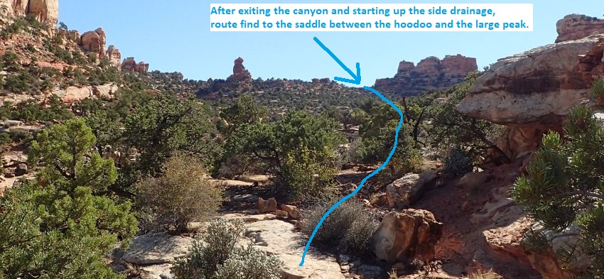
- StoneD19
Lat/Lon (WGS84): N 38.35369
W -111.25891
Elev: NaN Feet
Look southwest up the drainage and note a large hoodoo like structure and a large sandstone peak about 0.65 miles away. Route find your way over to the saddle between the hoodoo and sandstone peak. Travel is easier if you contour up out of the drainage and roughly follow it.
- StoneD20Sdle
Lat/Lon (WGS84): N 38.34578
W -111.26499
Elev: 6,990 Feet
Saddle between the sandstone peak and large hoodoo. Continue the exit by traveling south down through a small valley and up to a saddle on the other side. The hoodoo is the same hoodoo you saw across a small valley on the approach hike into Stone Dagger.
- StoneD05-Sdle
Lat/Lon (WGS84): N 38.34232
W -111.26657
Elev: 7,015 Feet
Saddle with views into a small valley like area to the north. Take note of what this area looks like as you will cross this same point on the exit route from the canyon.
To go to Stone Dagger Canyon, drop north down the slope toward the valley and veer left (northwest) to contour over to a saddle left of of a large rock hill. Note and remeber the large hoodoo directly across the valley to the northeast, you will be on that ridge on the exit from the canyon.
On the exit, reverse the approach route almost due south contouring along the slope toward the base of a small peak. Note: On exit it is possible to follow down the shallow drainage to the southwest but it soon becomes rough and difficult to travel with a lot of scrambling.
- StoneD04
Lat/Lon (WGS84): N 38.34079
W -111.26649
Elev: NaN Feet
Route traverses around the left (west) side of the smaller rock outcropping noted earlier for navigation. Continue north about 500 feet to a small saddle. On exit, continue south about 0.3 miles to the top of the ledges.
- StoneD02
Lat/Lon (WGS84): N 38.33595
W -111.26671
Elev: NaN Feet
Route begins to become a little less steep. From here you begin to see a red rock peak about 0.3 miles to the northeast. Visually follow the ridge line running left (west) down from the red peak to a smaller peak / outcropping of more yellow rock. Travel north to go around the left (west) side of that smaller peak / outcropping. On exit, continue south route finding and scrambling down ledges for about 700 feet to the ravine / wash below.
- StoneD01
Lat/Lon (WGS84): N 38.33459
W -111.26700
Elev: NaN Feet
Route gets to a long section of scrambling up steep with slickrock where good route finding is needed.
- jStoneDagger
Lat/Lon (WGS84): N 38.33412
W -111.26729
Elev: 6,420 Feet
Leave the drainage and begin routefinding north up a series of ledge. On our visit the route up the ledges had the occasional cairn but they may not remain, so they should not be depended on. On exit, turn left and go southeast down the wash a short distance to a large boulder.
- A-Door05
Lat/Lon (WGS84): N 38.33379
W -111.26687
Elev: NaN Feet
A very large boulder in the ravine with ledges on the left to help scramble up over it. From the top of the boulder you can see the ravine is getting wider and the grade becomes more gentle.
To go to Stone Dagger Canyon continue northwest about 150 feet farther up the ravine then leave the ravine to the right (north) scrambling up a series of ledges.
To go to A-Door-Able Canyon continue northwest up the wash about 375 feet to a brief top out in the ravine.
On exit from Stone Dagger, downclimb the boulder and continue down the ravine.
- A-Door04
Lat/Lon (WGS84): N 38.33309
W -111.26537
Elev: NaN Feet
Down in the main ravine. Scramble and boulder hop northwest up the ravine.
On exit from Stone Dagger, scramble up to the right (northish) up a boulder filled slope to the top of a side ravine.
- A-Door03
Lat/Lon (WGS84): N 38.33336
W -111.26464
Elev: NaN Feet
Top out of the small ravine on the right of the peak. Veer left and scramble down steep slickrock to the main ravine below.
On exit from Stone Dagger, scramble down the slopes about 500 feet down into a larger drainage with a couple of 4th class scrambles on the way.
- A-Door02
Lat/Lon (WGS84): N 38.33272
W -111.26378
Elev: NaN Feet
Rock gets steeper requiring more hands and feet in places. Staying far right seems to be the best route but effort is required to route find through this convoluted area. There is one spot you will need to climb 4th class up about 10 feet to continue up.
- A-Door01
Lat/Lon (WGS84): N 38.33233
W -111.26348
Elev: NaN Feet
Bottom of a rubble filled ravine leaving the drainage going up to the northwest. Note a small peak in the center of the ravine and routefind up the slopes to the right of that peak. As you get higher up the slopes, you will be going into a smaller ravine going up the right side of the center peak. There are a couple spots with exposed 4th class scrambling for a short distance.
On exit from Stone Dagger, turn right and walk south about 250 feet back into Spring Canyon.
- jA-Door-Able
Lat/Lon (WGS84): N 38.33168
W -111.26385
Elev: NaN Feet
Large drainage on the northeast side of Spring Canyon. To go to A-Door-Able or Stone Dagger Canyons go northeast up this large drainage.
To go to the Chimney Rock parking area travel south down Spring Canyon.
- jChimney-Spng
Lat/Lon (WGS84): N 38.32428
W -111.26421
Elev: 5,920 Feet
Confluence where Chimney Rock Canyon meets Spring Canyon with wooden signs posted.
To go to Stone Dagger or A-Door-Able canyons go north up Spring Canyon.
To go to the Chimney Rock parking area go west up Chimney Rock Canyon.
Warning: when exiting from Stone Dagger, A-Door-Able, or Pandoras Box Canyons, it is easy to walk right by this junction on the hike out and accidentally continue walking aimlessly south down Spring Canyon. Even with the wooded signs posted I have seen people just walk by and never see the sign.
- ChimRkCyn30
Lat/Lon (WGS84): N 38.32407
W -111.26967
Elev: NaN Feet
Side canyon joins in from the north with two large cottonwood trees just west of where the side canyon joins in.
- ySmokStak-Bt
Lat/Lon (WGS84): N 38.32288
W -111.27389
Elev: 6,000 Feet
Bottom exit of Smokestack Canyon where it dumps into Chimney Rock Canyon.
To go to the Chimney Rock parking area turn right (south) and walk up stream in Chimney Rock Canyon.
To go to Stone Dagger or A-Door-Able canyons continue east in the wash.
- wSmokStakRP-20
Lat/Lon (WGS84): N 38.31922
W -111.28163
Elev: NaN Feet
Large side canyon joins in from the north. To got to Stone Dagger or A-Door-Able canyons continue east in the wash.
- wSmokStakRP-21
Lat/Lon (WGS84): N 38.31766
W -111.28491
Elev: NaN Feet
Use trail goes up out of the draianage and up to the trail above.
To go to Stone Dagger or A-Door-Able canyons continue east down the wash.
To go to the Chimney Rock parking area walk up use trails to the main trail on the south side of the wash.
- jChim-SprgCyn2
Lat/Lon (WGS84): N 38.31741
W -111.28488
Elev: NaN Feet
Spot on the Chimney Rock Loop Trail where use trails leave the main trail and drop north down into the large drainage about 90 feet away.
To go to Stone Dagger or A-Door-Able Canyons, leave the main trail and follow use trails about 90 feet down into the major drainage below.
- jChim-SprgCyn1
Lat/Lon (WGS84): N 38.31756
W -111.29826
Elev: 6,300 Feet
Trail junction on the Chimney Rock Loop Trail.
To go to Stone Dagger or A-Door-Able canyons follow the trail northeast and not the trail to the south leading to Chimney Rock. About 350 feet east the trail will cross a drainage then continue east and roughly follow along a drainage below also going east.
On the hike back out to the parking area Follow the trail west about 0.5 miles back to the parking lot.
- tChimneyRock
Lat/Lon (WGS84): N 38.31570
W -111.30397
Elev: 6,055 Feet
Chimeny Rock Trailhead. Paved parking and a pit toilet.
|