Canyoneering Route Description
Stem School Canyon - 3A II
Capitol Reef National Park, Utah
05-18-18, 3 people, 1 Day (Travel time in route 3.5 hours)

Time Required - 3 to 5 hours
Distance - 1.5 miles Total, 0.6 miles Technical
Rappels - 4 Rappels, Longest Rappel 140 feet
but you will need 150 feet of rope.
Elevation Range - 5180 - 5600 Feet
Shuttle Required - No Vehicle - Passenger
Permit Required - Yes
Rappelling and anchor gear, Ropes and or pull cords for rappels up
to 150 feet and 50 feet of 1 inch webbing for sling placement. Wet
suits not needed but there is one pool where it is very likely you
will need to swim for about 20 feet if you can not stem over it.
Stem School is a little slot I had wanted to go look at for
a long time but never really got around to it. After Arch Nemesis we had time to
kill and John said he had also noticed the slot and was interested in joining me
and Tracy to check it out.
On the approach you will
find sections with crypto biotic soil. Please try to avoid the crypto and
follow any trails already forming or water runnels to avoid crushing crypto.
sometimes it is unavoidable but please try.
As expected Stem
School is not stellar but does work well for a short day close to the road with only a few
hours of commitment. The first rappel is interesting as you rappel down to
then over a hanging pothole sitting part way down a tall vertical wall. A few
down climbs, few rappels and some short stem sections add to the fun of Stem
School.
We could not think of a good name and I originally had
some school themed name to stay in keeping with Old School Canyon a short
distance away. After looking back on the days events John suggested the name
Stem School and it seemed to fit. There is a long pool that can be a deep
wade / swim but can be stemmed over. Ok, stemmed over by tall people. John
went over with relative ease. I made it most of the way before feeling
pretty stretched out but was able to pull it off (sometimes feeling like I
was doing an iron cross as my feet flailed looking for purchase). Tracy
being 5 foot 1 was just not tall enough to pull it off. John waded out and
gave her feet assistance for her to finish it off. This very memorable
moment from the route is why the name Stem School.
Note:
Groups descending this canyon
later sometimes refer to it as Dinner Mint or Cobra Canyon.
To get to the Trailhead
Start from the turn off of highway 24 to the Capitol Reef
Visitor Center. This is about 9.7 miles north on highway 24
from the town of Torrey, Utah, which is at the junction of
highways 12 and 24.
From the turn off to the Capitol Reef Visitor Center (vCapReefVisit)
drive south on highway 24 for about 1.6 miles to a small dirt
area on the left (northwest) side of the road (pkStemSchool).
This parking spot will be about 0.75 miles after passing the
Grand Wash trailhead.
To leave the Exit Vehicle / Escape Pod
No exit vehicle is needed. This is done as a loop route.
GPS coordinate information listed at the bottom. For information about waypoint naming and map symbols, refer to the
Glossary page.

Click the links for maps of the route.
Map of the entire route.
The Approach:
From the parking spot (pkStemSchool)
walk northeast along
highway 24 for about
1000 feet to where Stem
School meets the highway
on the right (south)
side of the road.
 This is what will show as the caption. It can be as long or short as you like.
The text will wrap and the border will expand down to accommodate.
This is what will show as the caption. It can be as long or short as you like.
The text will wrap and the border will expand down to accommodate.
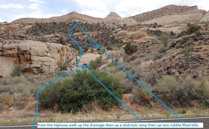
From where the Stem
School drainage meets
the road (jStemSchoolBt)
walk south up Stem
School about 200 feet
from the road to a
sloped slickrock ramp on
the LUC (east) side.
Scramble up the
slickrock ramp
(StemSchool01) up to the
dirt rim above. After
getting up to the open
dirt above continue
south about 220 feet to
the base of
(StemSchool02) a rubble
filled slope to walk up.
As you walk to the hill,
try to avoid crypto
where possible and use
any trails you find
already forming.
From the top of the
rubble filled hill
(StemSchool03) walk
south about 60 feet to
the base of
(StemSchool04) the next
rubble filled hill and
continue south up the
hill.
From the top of the
second rubble filled
hill (StemSchool05) walk
south toward the left
(east) side of the
sandstone peak to a spot
about 350 feet away
where you can scramble
up the steep slickrock.
Note:
The terrain to the
right (west) looks like
it will be more gentle
but you would be forced
to make a sketchy climb
at some point. Ask me
how i know this.
 This is what will show as the caption. It can be as long or short as you like.
The text will wrap and the border will expand down to accommodate.
This is what will show as the caption. It can be as long or short as you like.
The text will wrap and the border will expand down to accommodate.
When you get to the spot
where it is possible to
scramble up
(StemSchool06) steep
slickrock at the base of
a sandstone peak. Most
groups will need to
partner assist each
other up a short section
near the start of the
upclimb, while the rest
of the way up is easy
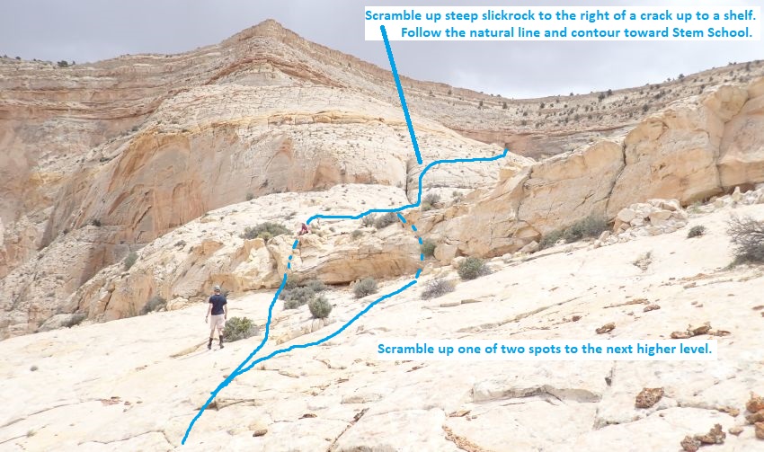
scrambling up. Once up
the steep part, walk a
little over 200 feet to
where you can easily
scramble up to the next
higher level. There are
two spots you can use
about 100 feet apart and
either works.
Once up to the next
higher level
(StemSchool07a) or
(StemSchool07b), walk
south about 500 feet to
the base of steep
slickrock and to the
right (west) side of a
crack / chute running up
 This is what will show as the caption. It can be as long or short as you like.
The text will wrap and the border will expand down to accommodate.
This is what will show as the caption. It can be as long or short as you like.
The text will wrap and the border will expand down to accommodate.
From the base of the
steep slickrock
(StemSchool08) scramble
up along the right
(west) side of the
crack. As it levels off
veer right (west) and
follow the natural line
a little over 500 feet
to where you can look
down (StemSchool09) into
Stem School.
Carefully walk /
scramble down steep
slickrock down into Stem
School (yStemSchoolTp).
The Canyoneering / Technical Section:
Once in Stem
School (yStemSchoolTp),
walk along the LDC side
for about 250 feet to
rap 1.
Rap 1 (dStemSchoolR1) is
anchored slightly LDC of
water course from a
small shrub or large
rock about 10 feet back
and drops about 140 feet
down a vertical wall
with a hanging pot hole
to cross part way down -
using about 150 feet of
rope. From the
bottom of the rap are a
few easy stem / galumph
downclimbs of 8 to 10
feet in narrow slot for
about 200 feet before
the walls widen out to
easy walking in
vegetated wash.
Almost 800 feet farther
is a confluence
(StemSchool10) with
another fork of Stem
School dropping in from
the LDC (southwest)
side. Continue down
canyon bridging over a
pool or scrambling the
sloped RDC wall to
bypass.
About 200 feet farther
is bowl / ravine
(StemSchool11) on the
RDC (east) side where
you could likely enter
or exit the canyon
scrambling moderately
sloped slickrock.
Continue down canyon
about 200 feet to rap 2.
Rap 2 (dStemSchoolR2) is
anchored on the LDC side
from a tree and uses
about 80 feet of rope as
it goes over to then
slowly rolls off
vertical down onto the
top of a large choke
stone. From the choke
stone, stem / elevator
down about 15 feet to
just above a pool where
you can easily stem over
the pool.
Note:
Rap 2 drops down to
the choke stone to
bypass a pothole at the
start of the slot here.
Optionally you can
anchor from the start of
the slot and play
through the pothole.
Bypassing allows one to
keep dry.
Shortly down canyon is a
long pool to stem over
(StemSchool12) that gets
wide near the end. Tall
people can get over this
pool with some effort
while shorter people
will likely need to
cross in chest deep to
swim depth water for
abut 30 feet. Just after
is one more pool to
easily stem over.
About 300 feet farther a
chute drops in from the
LDC (StemSchool13) where
you could scramble down
into canyon if you
walked the LDC ledges
from rap 2 to bypass the
rap and a couple pools.
A little less than 100
feet down canyon is rap
3.
Rap 3 (dStemSchoolR3) is
anchored from a tree
about 25 feet back and
drops about 40 feet
slightly overhanging.
Walk open wash about 220
feet to the next rap.
Rap 4 (dStemSchoolR4) is
anchored from a tree up
on the LDC side uses
about 60 feet of rope
with a vertical drop of
about 25 feet.
Note:
The tree in the
water course is weak and
does not feel secure
which is why the tree
over on the LDC side was
used.
About 400 feet farther
is a drop of about 25
feet (StemSchool14) that
can be downclimbed
directly, bypassed RDC
down a short rubble
filled ravine or
bypassed farther RDC
down slickrock ledges.
Walk the wash about 150
feet to where the canyon
walls begin to open up (yStemSchoolBt).
The Exit:
From
where the canyon opens
up (yStemSchoolBt) walk
another 150 feet back
out to the highway then
turn left and walk about
1000 feet back to the
car parking spot
(pkStemSchool).
Downloadable GPX files
available at
BG-Gear Store
(easier than manual entry and a great way to support
Bluugnome).
Waypoint naming convention and map symbol information can be found on the Glossary page.
Elevations are approximate.
BEFORE
manually entering coordinates set your system to WGS84 datum and Lat/Lon hddd.ddddd° coordinate format.
Inconsistent datum's and coordinate formats will result in location errors.
Click to show / expand the list of waypoints below........
| Stem School (1) - Approach |
- pkStemSchool
Lat/Lon (WGS84): N 38.28063
W -111.17947
Elev: 5,200 Feet
Dirt parking spot on northwest side of road. Park here to start Stem School or Beaver Bay Canyons.
To go to Stem School canyon walk northeast along hyw 24 for about 1000 feet to where Stem School meets the highway on the right (south) side of the road.
- jStemSchoolBt
Lat/Lon (WGS84): N 38.28277
W -111.17742
Elev: 5,180 Feet
Stem School drainage meets the highway here. On approach walk south up Stem School about 200 feet from the road to a sloped slickrock ramp on the LUC (east) side. On exit turn left to walk southwest along hyw 24 about 1000 feet to the car parking spot.
- StemSchool01
Lat/Lon (WGS84): N 38.28218
W -111.17721
Elev: NaN Feet
Slickrock ramp running up the LUC (east) side where you can easily scramble up to the dirt rim above. After getting up to the open dirt above continue south about 220 feet to the base of a rubble filled slope to walk up. As you walk to the hill, try to avoid crypto where possible and use any trails you find already forming.
- StemSchool02
Lat/Lon (WGS84): N 38.28159
W -111.17693
Elev: NaN Feet
Base of a rubble filled hill. Continue south up the hill.
- StemSchool03
Lat/Lon (WGS84): N 38.28114
W -111.17705
Elev: NaN Feet
Top of a rubble filled hill. Walk south about 60 feet to the base of the next rubble filled hill.
- StemSchool04
Lat/Lon (WGS84): N 38.28099
W -111.17693
Elev: NaN Feet
Base of a rubble filled hill. Continue south up the rubble filled hill.
- StemSchool05
Lat/Lon (WGS84): N 38.28047
W -111.17669
Elev: NaN Feet
Top of a rubble filled hill. Walk south toward the left (east) side of the sandstone peak to a spot about 350 feet away to where you can scramble up the steep slickrock.
Note: The terrain to the right (west) looks like it will be more gentle but you would be forced to make a sketchy climb at some point. Ask me how i know this.
- StemSchool06
Lat/Lon (WGS84): N 38.27954
W -111.17629
Elev: NaN Feet
Spot where you can scramble up steep slickrock at the base of a sandstone peak. Most groups will need to partner assist each other up a short section near the start of the upclimb, while the rest of the way up is easy scrambling up. Once up the steep part, walk a little over 200 feet to where you can easily scramable up to the next higher level. There are two spots you can use about 100 feet apart and either works.
- StemSchool07a
Lat/Lon (WGS84): N 38.27902
W -111.17616
Elev: NaN Feet
One of two spots where you can scramble up to the next higher level. Once up to the next level, walk south about 500 feet to the base of steep slickrock and to the right (west) side of a crack / chute running up the slickrock.
- StemSchool07b
Lat/Lon (WGS84): N 38.27873
W -111.17587
Elev: NaN Feet
One of two spots where you can scramble up to the next higher level.
- StemSchool08
Lat/Lon (WGS84): N 38.27760
W -111.17568
Elev: NaN Feet
Base of steep slickrock just right (west) of a crack / chute running up the the slickrock. Scramble up the steep slickrock along the right (west) side of the crack. As it levels off veer right (west) and follow the natural line a little over 500 feet to where you can look down into Stem School.
- StemSchool09
Lat/Lon (WGS84): N 38.27618
W -111.17622
Elev: NaN Feet
You can look down into Stem School and carefully walk / scramble down steep slickrock down into Stem School.
- yStemSchoolTp
Lat/Lon (WGS84): N 38.27598
W -111.17637
Elev: 5,600 Feet
Top of Stem School Canyon where the route scrambles down to the canyon floor. Walk along the LDC side for about 250 feet to rap 1.
|
| Stem School (2) - Canyon and Exit |
- yStemSchoolTp
Lat/Lon (WGS84): N 38.27598
W -111.17637
Elev: 5,600 Feet
Top of Stem School Canyon where the route scrambles down to the canyon floor. Walk along the LDC side for about 250 feet to rap 1.
- dStemSchoolR1
Lat/Lon (WGS84): N 38.27660
W -111.17665
Elev: NaN Feet
Rap1 - Stem School. Anchored slightly LDC of water course from a small shrub or large rock about 10 feet back and drops about 140 feet down a vertical wall with a hanging pot hole to cross part way down - using about 150 feet of rope. From the bottom of the rap are a few easy stem / galumph downclimbs of 8 to 10 feet in narrow slot for about 200 feet before the walls widen out to easy walking in vegetated wash.
- StemSchool10
Lat/Lon (WGS84): N 38.27824
W -111.17820
Elev: NaN Feet
Confluence with another fork of Stem School dropping in from the LDC (southwest) side. Continue down canyon bridging over a pool or scrambling the sloped RDC wall to bypass.
- StemSchool11
Lat/Lon (WGS84): N 38.27870
W -111.17774
Elev: NaN Feet
Bowl / ravine on the RDC (east) side where you could likely enter or exit the canyon scrambling moderately sloped slickrock.
- dStemSchoolR2
Lat/Lon (WGS84): N 38.27932
W -111.17810
Elev: NaN Feet
Rap 2 - Stem School Canyon. Anchored on the LDC side from a tree and uses about 80 feet of rope as it goes over to then slowly rolls off vertical down onto the top of a large choke stone. From the choke stone, stem / elevator down about 15 feet to just above a pool where you can easily stem over the pool.
Note: Rap 2 drops down to the choke stone to bypass a pothole at the start of the slot here. Optionally you can anchor from the start of the slot and play through the pothole. Bypassing allows one to keep dry.
- StemSchool12
Lat/Lon (WGS84): N 38.27966
W -111.17817
Elev: NaN Feet
Long pool to stem over that gets wide near the end. Tall people can get over this pool with some effort while shorter people will likely need to cross in chest deep to swim depth water for abut 30 feet. Just after is one more pool to easily stem over.
- StemSchool13
Lat/Lon (WGS84): N 38.28047
W -111.17803
Elev: NaN Feet
Chute drops in from the LDC where you could scramble down into canyon if you walked the LDC ledges from rap 2 to bypass the rap and a couple pools.
- dStemSchoolR3
Lat/Lon (WGS84): N 38.28066
W -111.17775
Elev: NaN Feet
Rap 3 - Stem School. Anchored from a tree about 25 feet back and drops about 40 feet slightly overhanging. Walk open wash about 220 feet to the next rap.
- dStemSchoolR4
Lat/Lon (WGS84): N 38.28115
W -111.17769
Elev: NaN Feet
Rap 4 - Stem School. Anchored from a tree up on the LDC side uses about 60 feet of rope with a vertical drop of about 25 feet.
Note: The tree in the water course is weak and does not feel secure which is why the tree over on the LDC side was used.
- StemSchool14
Lat/Lon (WGS84): N 38.28198
W -111.17740
Elev: NaN Feet
Drop of about 25 feet that can be downclimbed directly, bypassed RDC down a short rubble filled ravine or bypassed farther RDC down slickrock ledges. Walk the wash about 300 feet out to the highway.
- yStemSchoolBt
Lat/Lon (WGS84): N 38.28244
W -111.17733
Elev: 5,190 Feet
Where the canyon walls end and open wash continues out the highway. On approach walk about 80 feet up canyon to a slickrock ramp on the LDC side to scramble up. On exit walk about 120 feet to the highway.
- jStemSchoolBt
Lat/Lon (WGS84): N 38.28277
W -111.17742
Elev: 5,180 Feet
Stem School drainage meets the highway here. On approach walk south up Stem School about 200 feet from the road to a sloped slickrock ramp on the LUC (east) side. On exit turn left to walk southwest along hyw 24 about 1000 feet to the car parking spot.
- pkStemSchool
Lat/Lon (WGS84): N 38.28063
W -111.17947
Elev: 5,200 Feet
Dirt parking spot on northwest side of road. Park here to start Stem School or Beaver Bay Canyons.
To go to Stem School canyon walk northeast along hyw 24 for about 1000 feet to where Stem School meets the highway on the right (south) side of the road.
|